
Order Total (1 Item Items):
Shipping Destination:

Emmanuel Bowen (247 results)
Skip to main search results
Product Type
- All Product Types
- Books (5)
- Magazines & Periodicals
- Comics
- Sheet Music
- Art, Prints & Posters (17)
- Photographs
- Maps (225)
-
Manuscripts &
Paper Collectibles
Condition
- All Conditions
- New
- Used
Binding
Collectible Attributes
- First Edition (1)
- Signed
- Dust Jacket
- Seller-Supplied Images (245)
- Not Printed On Demand
Free Shipping
Seller Location
Seller Rating
-
[Llanvelling-Llanfair-Tregynon-Newtown-Llanbadarn Fynydd] - The Road from Chester to Cardiff
Publication Date: 1753
Map
Condition: Good. Llanvelling-Llanfair-Tregynon-Newtown-Llanbadarn Fynydd OWEN/BOWEN road map 1753. Antique copperplate road strip map; John Owen & Emmanuel Bowen (1753). 12.5 x 19.0cm, 5 x 7.5 inches. Condition: Good. The image shown may have been taken from a different example of this map than that which is offered for sale. The map you will receive is in good condition but there may be minor variations in the condition from that shown in the image. This sheet is printed on both sides of the page. Plate number 165 is shown. Plate number 166: [Llanbadarn Fynydd-Builth Wells-Brecon] is printed on the reverse side. The printing on the reverse side may show through to the front to some extent. The Road from Chester to Cardiff: plate 3 of 5: Tregynon-Newtown.
-
[Llanbadarn Fynydd-Builth Wells-Brecon] - The Road from Chester to Cardiff
Publication Date: 1753
Map
Condition: Good. Llanbadarn Fynydd-Builth Wells-Brecon road map by J. OWEN & E. BOWEN 1753. Antique copperplate road strip map; John Owen & Emmanuel Bowen (1753). 12.5 x 19.0cm, 5 x 7.5 inches. Condition: Good. The image shown may have been taken from a different example of this map than that which is offered for sale. The map you will receive is in good condition but there may be minor variations in the condition from that shown in the image. This sheet is printed on both sides of the page. Plate number 166 is shown. Plate number 165: [Llanvelling-Llanfair-Tregynon-Newtown-Llanbadarn Fynydd] is printed on the reverse side. The printing on the reverse side may show through to the front to some extent. The Road from Chester to Cardiff: plate 4 of 5: Llanbadarn Fynydd-Brecon.
-
[Bala-Betws Gwerfil Goch-Ruthin-Holywell] - The Road from St. Davids to Holywell
Publication Date: 1753
Map
Condition: Good. Bala-Betws Gwerfil Goch-Ruthin-Holywell road map by J. OWEN & E. BOWEN 1753. Antique copperplate road strip map; John Owen & Emmanuel Bowen (1753). 12.5 x 19.0cm, 5 x 7.5 inches. Condition: Good. The image shown may have been taken from a different example of this map than that which is offered for sale. The map you will receive is in good condition but there may be minor variations in the condition from that shown in the image. This sheet is printed on both sides of the page. Plate number 175 is shown. Plate number 176: The Road from Exeter to Barnstable. Exeter is printed on the reverse side. The printing on the reverse side may show through to the front to some extent. The Road from St. Davids to Holywell: plate 5 of 5: Bala-Ruthin-Holywell.
-
Condition: Good. The Road from Exeter to Barnstable. Exeter 1753 old antique print picture. Antique copperplate print; John Owen & Emmanuel Bowen (1753). 12.5 x 19.0cm, 5 x 7.5 inches. Condition: Good. The image shown may have been taken from a different example of this print than that which is offered for sale. The print you will receive is in good condition but there may be minor variations in the condition from that shown in the image. This sheet is printed on both sides of the page. Plate number 176 is shown. Plate number 175: [Bala-Betws Gwerfil Goch-Ruthin-Holywell] is printed on the reverse side. The printing on the reverse side may show through to the front to some extent. The Road from Exeter to Barnstable: plate 1 of 3: The Road from Exeter to Barnstable. Exeter.
-
[Llandaff-St Nicholas-Cowbridge-Corntown-Aberavon-Briton Ferry] - The Road from London to St. Davids
Publication Date: 1753
Map
Condition: Good. Llandaff-Cowbridge-Corntown-Aberavon-Briton Ferry OWEN/BOWEN road map 1753. Antique copperplate road strip map; John Owen & Emmanuel Bowen (1753). 12.5 x 19.0cm, 5 x 7.5 inches. Condition: Good. The image shown may have been taken from a different example of this map than that which is offered for sale. The map you will receive is in good condition but there may be minor variations in the condition from that shown in the image. This sheet is printed on both sides of the page. Plate number 38 is shown. Plate number 37: [Monmouth-Newchurch-Newport-Cardiff] is printed on the reverse side. The printing on the reverse side may show through to the front to some extent. The Road from London to St. Davids: plate 7 of 9: Llandough-St Nicholas-Cowbridge-Corntown-Port Talbot.
-
[Leeming-Richmond-Barnard Castle. Ferrybridge-Pontefract-Wakefield] - The Road from Ferribridg to Borobridg
Publication Date: 1753
Map
Condition: Good. Leeming-Richmond-Barnard Castle. Ferrybridge-Wakefield OWEN/BOWEN road map 1753. Antique copperplate road strip map; John Owen & Emmanuel Bowen (1753). 12.5 x 19.0cm, 5 x 7.5 inches. Condition: Good. The image shown may have been taken from a different example of this map than that which is offered for sale. The map you will receive is in good condition but there may be minor variations in the condition from that shown in the image. This sheet is printed on both sides of the page. Plate number 258 is shown. Plate number 257: [Ferrybridge/Knottingley-Brotherton-Micklefield-Aberford-Wetherby-Bor oughbridge-Ripon] is printed on the reverse side. The printing on the reverse side may show through to the front to some extent. The Road from Ferribridg to Borobridg: plate 3 of 3: Leeming-Richmond-Barnard Castle-Ferrybridge-Wakefield.
-
[Llandovery-Abermarlais-Carmarthen] - The Road from Prestain to Carmarthen
Publication Date: 1753
Map
Condition: Good. Llandovery-Abermarlais-Carmarthen road strip map by J. OWEN & E. BOWEN 1753. Antique copperplate road strip map; John Owen & Emmanuel Bowen (1753). 12.5 x 19.0cm, 5 x 7.5 inches. Condition: Good. The image shown may have been taken from a different example of this map than that which is offered for sale. The map you will receive is in good condition but there may be minor variations in the condition from that shown in the image. This sheet is printed on both sides of the page. Plate number 226 is shown. Plate number 225: [Presteigne-New Radnor-Builth Wells] is printed on the reverse side. The printing on the reverse side may show through to the front to some extent. The Road from Prestain to Carmarthen: plate 3 of 3: Llandovery-Carmarthen.
-
[Ferrybridge/Knottingley-Brotherton-Micklefield-Aberford-Wetherby-Boroughbridge-Ripon] - The Road from Ferribridg to Borobridg
Publication Date: 1753
Map
Condition: Good. Knottingley-Brotherton-Aberford-Wetherby-Boroughbridge-Ripon OWEN/BOWEN map 1753. Antique copperplate road strip map; John Owen & Emmanuel Bowen (1753). 12.5 x 19.0cm, 5 x 7.5 inches. Condition: Good. The image shown may have been taken from a different example of this map than that which is offered for sale. The map you will receive is in good condition but there may be minor variations in the condition from that shown in the image. This sheet is printed on both sides of the page. Plate number 257 is shown. Plate number 258: [Leeming-Richmond-Barnard Castle. Ferrybridge-Pontefract-Wakefield] is printed on the reverse side. The printing on the reverse side may show through to the front to some extent. The Road from Ferribridg to Borobridg: plate 2 of 3: Ferrybridge-Brotherton-Aberford-Boroughbridge-Ripon.
-
[Stilton-Peterborough-Crowland-Spalding-Surfleet] - The Road from London to Boston, commencing at Stilton
Publication Date: 1753
Map
Condition: Good. Stilton-Peterborough-Crowland-Spalding-Surfleet road map by OWEN & BOWEN 1753. Antique copperplate road strip map; John Owen & Emmanuel Bowen (1753). 12.5 x 19.0cm, 5 x 7.5 inches. Condition: Good. The image shown may have been taken from a different example of this map than that which is offered for sale. The map you will receive is in good condition but there may be minor variations in the condition from that shown in the image. This sheet is printed on both sides of the page. Plate number 88 is shown. Plate number 87: The Road from London to Boston, commencing at Stilton. The Description of London - continued is printed on the reverse side. The printing on the reverse side may show through to the front to some extent. The Road from London to Boston, commencing at Stilton: plate 2 of 3: Stilton-Peterborough-Crowland-Spalding-Surfleet.
-
[Monmouth-Newchurch-Newport-Cardiff] - The Road from London to St. Davids
Publication Date: 1753
Map
Condition: Good. Monmouth-Newchurch-Newport-Cardiff road strip map by J. OWEN & E. BOWEN 1753. Antique copperplate road strip map; John Owen & Emmanuel Bowen (1753). 12.5 x 19.0cm, 5 x 7.5 inches. Condition: Good. The image shown may have been taken from a different example of this map than that which is offered for sale. The map you will receive is in good condition but there may be minor variations in the condition from that shown in the image. This sheet is printed on both sides of the page. Plate number 37 is shown. Plate number 38: [Llandaff-St Nicholas-Cowbridge-Corntown-Aberavon-Briton Ferry] is printed on the reverse side. The printing on the reverse side may show through to the front to some extent. The Road from London to St. Davids: plate 6 of 9: Monmouth-Newchurch-Newport-Cardiff.
-
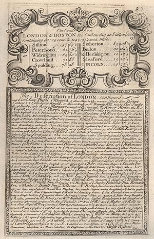
The Road from London to Boston, commencing at Stilton. The Description of London - continued
Publication Date: 1753
Art / Print / Poster
Condition: Good. Road from London to Boston starting at Stilton. Description of London contd 1753. Antique copperplate print; John Owen & Emmanuel Bowen (1753). 12.5 x 19.0cm, 5 x 7.5 inches. Condition: Good. The image shown may have been taken from a different example of this print than that which is offered for sale. The print you will receive is in good condition but there may be minor variations in the condition from that shown in the image. This sheet is printed on both sides of the page. Plate number 87 is shown. Plate number 88: [Stilton-Peterborough-Crowland-Spalding-Surfleet] is printed on the reverse side. The printing on the reverse side may show through to the front to some extent. The Road from London to Boston, commencing at Stilton: plate 1 of 3: The Road from London to Boston, commencing at Stilton. The Description of London - continued.
-
[Presteigne-New Radnor-Builth Wells] - The Road from Prestain to Carmarthen
Publication Date: 1753
Map
Condition: Good. Presteigne-New Radnor-Builth Wells road strip map by J. OWEN & E. BOWEN 1753. Antique copperplate road strip map; John Owen & Emmanuel Bowen (1753). 12.5 x 19.0cm, 5 x 7.5 inches. Condition: Good. The image shown may have been taken from a different example of this map than that which is offered for sale. The map you will receive is in good condition but there may be minor variations in the condition from that shown in the image. This sheet is printed on both sides of the page. Plate number 225 is shown. Plate number 226: [Llandovery-Abermarlais-Carmarthen] is printed on the reverse side. The printing on the reverse side may show through to the front to some extent. The Road from Prestain to Carmarthen: plate 2 of 3: Presteigne-New Radnor-Builth Wells.
-
Condition: Good. Andover-Amesbury-Warminster road strip map by J. OWEN & E. BOWEN 1753 old. Antique copperplate road strip map; John Owen & Emmanuel Bowen (1753). 12.5 x 19.0cm, 5 x 7.5 inches. Condition: Good. The image shown may have been taken from a different example of this map than that which is offered for sale. The map you will receive is in good condition but there may be minor variations in the condition from that shown in the image. This sheet is printed on both sides of the page. Plate number 78 is shown. Plate number 77: The Road from London to Barnstable. The Description of London - continued is printed on the reverse side. The printing on the reverse side may show through to the front to some extent. The Road from London to Barnstable: plate 2 of 7: Andover-Amesbury-Warminster.
-
Condition: Good. Bridgwater-Willett-Dulverton road strip map by J. OWEN & E. BOWEN 1753 old. Antique copperplate road strip map; John Owen & Emmanuel Bowen (1753). 12.5 x 19.0cm, 5 x 7.5 inches. Condition: Good. The image shown may have been taken from a different example of this map than that which is offered for sale. The map you will receive is in good condition but there may be minor variations in the condition from that shown in the image. This sheet is printed on both sides of the page. Plate number 80 is shown. Plate number 79: [Maiden Bradley-Bruton-Alford-East Lydford-Bridgwater] is printed on the reverse side. The printing on the reverse side may show through to the front to some extent. The Road from London to Barnstable: plate 4 of 7: Bridgwater-Willett-Dulverton.
-
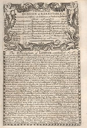
The Road from London to Barnstable. The Description of London - continued
Publication Date: 1753
Art / Print / Poster
Condition: Good. The Road from London to Barnstable. The Description of London - continued 1753. Antique copperplate print; John Owen & Emmanuel Bowen (1753). 12.5 x 19.0cm, 5 x 7.5 inches. Condition: Good. The image shown may have been taken from a different example of this print than that which is offered for sale. The print you will receive is in good condition but there may be minor variations in the condition from that shown in the image. This sheet is printed on both sides of the page. Plate number 77 is shown. Plate number 78: [Andover-Amesbury-Warminster] is printed on the reverse side. The printing on the reverse side may show through to the front to some extent. The Road from London to Barnstable: plate 1 of 7: The Road from London to Barnstable. The Description of London - continued.
-
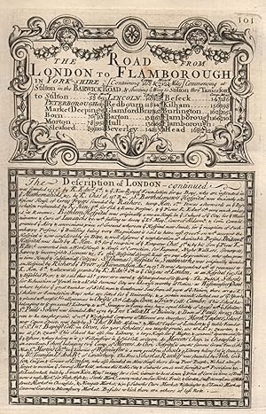
The Road from London to Flamborough. The Description of London - continued
Publication Date: 1753
Art / Print / Poster
Condition: Good. The Road from London to Flamborough. The Description of London - continued 1753. Antique copperplate print; John Owen & Emmanuel Bowen (1753). 12.5 x 19.0cm, 5 x 7.5 inches. Condition: Good. The image shown may have been taken from a different example of this print than that which is offered for sale. The print you will receive is in good condition but there may be minor variations in the condition from that shown in the image. This sheet is printed on both sides of the page. Plate number 101 is shown. Plate number 102: [Tempsford-Eaton-St Neots-Stilton-Peterborough] is printed on the reverse side. The printing on the reverse side may show through to the front to some extent. The Road from London to Flamborough: plate 1 of 5: The Road from London to Flamborough. The Description of London - continued.
-
[Tempsford-Eaton-St Neots-Stilton-Peterborough] - The Road from London to Flamborough
Publication Date: 1753
Map
Condition: Good. Tempsford-Eaton-St Neots-Stilton-Peterborough road map by OWEN & BOWEN 1753. Antique copperplate road strip map; John Owen & Emmanuel Bowen (1753). 12.5 x 19.0cm, 5 x 7.5 inches. Condition: Good. The image shown may have been taken from a different example of this map than that which is offered for sale. The map you will receive is in good condition but there may be minor variations in the condition from that shown in the image. This sheet is printed on both sides of the page. Plate number 102 is shown. Plate number 101: The Road from London to Flamborough. The Description of London - continued is printed on the reverse side. The printing on the reverse side may show through to the front to some extent. The Road from London to Flamborough: plate 2 of 5: Eton-Stilton-Peterborough.
-
[Maiden Bradley-Bruton-Alford-East Lydford-Bridgwater] - The Road from London to Barnstable
Publication Date: 1753
Map
Condition: Good. Maiden Bradley-Bruton-Alford-East Lydford-Bridgwater OWEN/BOWEN road map 1753. Antique copperplate road strip map; John Owen & Emmanuel Bowen (1753). 12.5 x 19.0cm, 5 x 7.5 inches. Condition: Good. The image shown may have been taken from a different example of this map than that which is offered for sale. The map you will receive is in good condition but there may be minor variations in the condition from that shown in the image. This sheet is printed on both sides of the page. Plate number 79 is shown. Plate number 80: [Bridgwater-Willett-Dulverton] is printed on the reverse side. The printing on the reverse side may show through to the front to some extent. The Road from London to Barnstable: plate 3 of 7: Maiden Bradley-Bruton-Alford-Bridgwater.
-
[Jedburgh-Kelso-Carham-Berwick upon Tweed] - The Road from Carlisle to Barwick
Publication Date: 1753
Map
Condition: Good. Jedburgh-Kelso-Carham-Berwick upon Tweed road map by J. OWEN & E. BOWEN 1753. Antique copperplate road strip map; John Owen & Emmanuel Bowen (1753). 12.5 x 19.0cm, 5 x 7.5 inches. Condition: Good. The image shown may have been taken from a different example of this map than that which is offered for sale. The map you will receive is in good condition but there may be minor variations in the condition from that shown in the image. This sheet is printed on both sides of the page. Plate number 162 is shown. Plate number 161: [Carlisle-Blackford-Kirklinton-Kershopefoot] is printed on the reverse side. The printing on the reverse side may show through to the front to some extent. The Road from Carlisle to Barwick: plate 3 of 3: Jedburgh-Kelso-Carham-Berwick upon Tweed.
-
[Haydon Bridge-Haltwhistle-Warwick Bridge-Carlisle] - The Road from Tinmouth com. Northumb to Carlisle in Cumberland
Publication Date: 1753
Map
Condition: Good. Haydon Bridge-Haltwhistle-Warwick Bridge-Carlisle road map by OWEN & BOWEN 1753. Antique copperplate road strip map; John Owen & Emmanuel Bowen (1753). 12.5 x 19.0cm, 5 x 7.5 inches. Condition: Good. The image shown may have been taken from a different example of this map than that which is offered for sale. The map you will receive is in good condition but there may be minor variations in the condition from that shown in the image. This sheet is printed on both sides of the page. Plate number 232 is shown. Plate number 231: [Tynemouth-Newcastle upon Tyne-Ovington-Hexham] is printed on the reverse side. The printing on the reverse side may show through to the front to some extent. The Road from Tinmouth com. Northumb to Carlisle in Cumberland: plate 3 of 3: Haydon Bridge-Haltwhistle-Warwick Bridge-Carlisle.
-
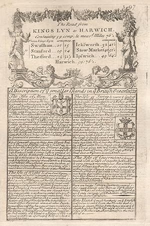
The Road from Kings Lyn to Harwich. A Description of ye smaller Islandsin ye British Ocean
Publication Date: 1753
Art / Print / Poster
Condition: Good. The Road from Kings Lyn to Harwich. Yye smaller Islandsin ye British Ocean 1753. Antique copperplate print; John Owen & Emmanuel Bowen (1753). 12.5 x 19.0cm, 5 x 7.5 inches. Condition: Good. The image shown may have been taken from a different example of this print than that which is offered for sale. The print you will receive is in good condition but there may be minor variations in the condition from that shown in the image. This sheet is printed on both sides of the page. Plate number 197 is shown. Plate number 198: [King's Lynn-Narborough-Swaffham-Thetford] is printed on the reverse side. The printing on the reverse side may show through to the front to some extent. The Road from Kings Lyn to Harwich: plate 1 of 3: The Road from Kings Lyn to Harwich. A Description of ye smaller Islandsin ye British Ocean.
-
[King's Lynn-Narborough-Swaffham-Thetford] - The Road from Kings Lyn to Harwich
Publication Date: 1753
Map
Condition: Good. King's Lynn-Narborough-Swaffham-Thetford road map by J. OWEN & E. BOWEN 1753. Antique copperplate road strip map; John Owen & Emmanuel Bowen (1753). 12.5 x 19.0cm, 5 x 7.5 inches. Condition: Good. The image shown may have been taken from a different example of this map than that which is offered for sale. The map you will receive is in good condition but there may be minor variations in the condition from that shown in the image. This sheet is printed on both sides of the page. Plate number 198 is shown. Plate number 197: The Road from Kings Lyn to Harwich. A Description of ye smaller Islandsin ye British Ocean is printed on the reverse side. The printing on the reverse side may show through to the front to some extent. The Road from Kings Lyn to Harwich: plate 2 of 3: King's Lynn-Narborough-Swaffham-Thetford.
-
[Tynemouth-Newcastle upon Tyne-Ovington-Hexham] - The Road from Tinmouth com. Northumb to Carlisle in Cumberland
Publication Date: 1753
Map
Condition: Good. Tynemouth-Newcastle upon Tyne-Ovington-Hexham road map by OWEN & BOWEN 1753. Antique copperplate road strip map; John Owen & Emmanuel Bowen (1753). 12.5 x 19.0cm, 5 x 7.5 inches. Condition: Good. The image shown may have been taken from a different example of this map than that which is offered for sale. The map you will receive is in good condition but there may be minor variations in the condition from that shown in the image. This sheet is printed on both sides of the page. Plate number 231 is shown. Plate number 232: [Haydon Bridge-Haltwhistle-Warwick Bridge-Carlisle] is printed on the reverse side. The printing on the reverse side may show through to the front to some extent. The Road from Tinmouth com. Northumb to Carlisle in Cumberland: plate 2 of 3: Tynemouth-Newcastle upon Tyne-Ovington-Hexham.
-
[Carlisle-Blackford-Kirklinton-Kershopefoot] - The Road from Carlisle to Barwick
Publication Date: 1753
Map
Condition: Good. Carlisle-Blackford-Kirklinton-Kershopefoot road map by OWEN & BOWEN 1753. Antique copperplate road strip map; John Owen & Emmanuel Bowen (1753). 12.5 x 19.0cm, 5 x 7.5 inches. Condition: Good. The image shown may have been taken from a different example of this map than that which is offered for sale. The map you will receive is in good condition but there may be minor variations in the condition from that shown in the image. This sheet is printed on both sides of the page. Plate number 161 is shown. Plate number 162: [Jedburgh-Kelso-Carham-Berwick upon Tweed] is printed on the reverse side. The printing on the reverse side may show through to the front to some extent. The Road from Carlisle to Barwick: plate 2 of 3: Carlisle-Blackford-Kirklinton-Kershopefoot.
-
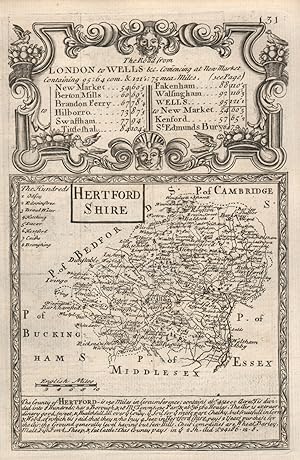
Condition: Good. 'Hertford-Shire'. County map by J. OWEN & E. BOWEN. Hertfordshire 1753 old. Antique copperplate county map; John Owen & Emmanuel Bowen (1753). 12.5 x 19.0cm, 5 x 7.5 inches. Condition: Good. The image shown may have been taken from a different example of this map than that which is offered for sale. The map you will receive is in good condition but there may be minor variations in the condition from that shown in the image. This sheet is printed on both sides of the page. Plate number 131 is shown. Plate number 132: [Newmarket-Barton Mills-Brandon-Swaffham] is printed on the reverse side. The printing on the reverse side may show through to the front to some extent. The Road from London to Wells & commencing at New Market: plate 1 of 3: Hertford-Shire.
-
[Newmarket-Barton Mills-Brandon-Swaffham] - The Road from London to Wells & commencing at New Market
Publication Date: 1753
Map
Condition: Good. Newmarket-Barton Mills-Brandon-Swaffham road map by J. OWEN & E. BOWEN 1753. Antique copperplate road strip map; John Owen & Emmanuel Bowen (1753). 12.5 x 19.0cm, 5 x 7.5 inches. Condition: Good. The image shown may have been taken from a different example of this map than that which is offered for sale. The map you will receive is in good condition but there may be minor variations in the condition from that shown in the image. This sheet is printed on both sides of the page. Plate number 132 is shown. Plate number 131: Hertford-Shire is printed on the reverse side. The printing on the reverse side may show through to the front to some extent. The Road from London to Wells & commencing at New Market: plate 2 of 3: Newmarket-Barton Mills-Brandon-Swaffham.
-
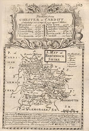
Condition: Good. 'A Map of Brecknock-Shire'. County map by OWEN & BOWEN. Brecknockshire 1753. Antique copperplate county map; John Owen & Emmanuel Bowen (1753). 12.5 x 19.0cm, 5 x 7.5 inches. Condition: Good. The image shown may have been taken from a different example of this map than that which is offered for sale. The map you will receive is in good condition but there may be minor variations in the condition from that shown in the image. This sheet is printed on both sides of the page. Plate number 163 is shown. Plate number 164: [Chester-Wrexham-Ruabon-Selattyn-Llanfyllin] is printed on the reverse side. The printing on the reverse side may show through to the front to some extent. The Road from Chester to Cardiff: plate 1 of 5: A Map of Brecknock-Shire.
-
[Chester-Wrexham-Ruabon-Selattyn-Llanfyllin] - The Road from Chester to Cardiff
Publication Date: 1753
Map
Condition: Good. Chester-Wrexham-Ruabon-Selattyn-Llanfyllin road map by OWEN & BOWEN 1753. Antique copperplate road strip map; John Owen & Emmanuel Bowen (1753). 12.5 x 19.0cm, 5 x 7.5 inches. Condition: Good. The image shown may have been taken from a different example of this map than that which is offered for sale. The map you will receive is in good condition but there may be minor variations in the condition from that shown in the image. This sheet is printed on both sides of the page. Plate number 164 is shown. Plate number 163: A Map of Brecknock-Shire is printed on the reverse side. The printing on the reverse side may show through to the front to some extent. The Road from Chester to Cardiff: plate 2 of 5: Chester-Wrexham-Ruabon-Llanfyllin.
-
[Southam-Coventry-Nuneaton-Ashby de la Zouch-Derby] - The Road from Oxford to Coventry continued to Derby
Publication Date: 1753
Map
Condition: Good. Southam-Coventry-Nuneaton-Ashby de la Zouch-Derby road map by OWEN & BOWEN 1753. Antique copperplate road strip map; John Owen & Emmanuel Bowen (1753). 12.5 x 19.0cm, 5 x 7.5 inches. Condition: Good. The image shown may have been taken from a different example of this map than that which is offered for sale. The map you will receive is in good condition but there may be minor variations in the condition from that shown in the image. This sheet is printed on both sides of the page. Plate number 220 is shown. Plate number 219: [Oxford-Deddington-Banbury] is printed on the reverse side. The printing on the reverse side may show through to the front to some extent. The Road from Oxford to Coventry continued to Derby: plate 3 of 3: Southam-Coventry-Nuneaton-Ashby de la Zouch-Derby.
-
[Grantham-Foston-Newark-on-Trent-Tuxford] - The Road from London to Barwick
Publication Date: 1753
Map
Condition: Good. Grantham-Foston-Newark-on-Trent-Tuxford road map by J. OWEN & E. BOWEN 1753. Antique copperplate road strip map; John Owen & Emmanuel Bowen (1753). 12.5 x 19.0cm, 5 x 7.5 inches. Condition: Good. The image shown may have been taken from a different example of this map than that which is offered for sale. The map you will receive is in good condition but there may be minor variations in the condition from that shown in the image. This sheet is printed on both sides of the page. Plate number 15 is shown. Plate number 16: [Tuxford-Barnby Moor-Bawtry-Doncaster] is printed on the reverse side. The printing on the reverse side may show through to the front to some extent. The Road from London to Barwick: plate 5 of 11: Grantham-Foston-Newark-on-Trent-Tuxford.
![Seller image for [Llanvelling-Llanfair-Tregynon-Newtown-Llanbadarn Fynydd] - The Road from Chester to Cardiff for sale by Antiqua Print Gallery](https://pictures.abebooks.com/inventory/md/md31106558728.jpg)
![Seller image for [Llanbadarn Fynydd-Builth Wells-Brecon] - The Road from Chester to Cardiff for sale by Antiqua Print Gallery](https://pictures.abebooks.com/inventory/md/md31106563394.jpg)
![Seller image for [Bala-Betws Gwerfil Goch-Ruthin-Holywell] - The Road from St. Davids to Holywell for sale by Antiqua Print Gallery](https://pictures.abebooks.com/inventory/md/md31106566242.jpg)

![Seller image for [Llandaff-St Nicholas-Cowbridge-Corntown-Aberavon-Briton Ferry] - The Road from London to St. Davids for sale by Antiqua Print Gallery](https://pictures.abebooks.com/inventory/md/md31106560534.jpg)
![Seller image for [Leeming-Richmond-Barnard Castle. Ferrybridge-Pontefract-Wakefield] - The Road from Ferribridg to Borobridg for sale by Antiqua Print Gallery](https://pictures.abebooks.com/inventory/md/md31106561477.jpg)
![Seller image for [Llandovery-Abermarlais-Carmarthen] - The Road from Prestain to Carmarthen for sale by Antiqua Print Gallery](https://pictures.abebooks.com/inventory/md/md31106562441.jpg)
![Seller image for [Ferrybridge/Knottingley-Brotherton-Micklefield-Aberford-Wetherby-Boroughbridge-Ripon] - The Road from Ferribridg to Borobridg for sale by Antiqua Print Gallery](https://pictures.abebooks.com/inventory/md/md31106562456.jpg)
![Seller image for [Stilton-Peterborough-Crowland-Spalding-Surfleet] - The Road from London to Boston, commencing at Stilton for sale by Antiqua Print Gallery](https://pictures.abebooks.com/inventory/md/md31106565309.jpg)
![Seller image for [Monmouth-Newchurch-Newport-Cardiff] - The Road from London to St. Davids for sale by Antiqua Print Gallery](https://pictures.abebooks.com/inventory/md/md31106566226.jpg)
![Seller image for [Presteigne-New Radnor-Builth Wells] - The Road from Prestain to Carmarthen for sale by Antiqua Print Gallery](https://pictures.abebooks.com/inventory/md/md31106567113.jpg)
![Seller image for [Andover-Amesbury-Warminster] - The Road from London to Barnstable for sale by Antiqua Print Gallery](https://pictures.abebooks.com/inventory/md/md31106552726.jpg)
![Seller image for [Bridgwater-Willett-Dulverton] - The Road from London to Barnstable for sale by Antiqua Print Gallery](https://pictures.abebooks.com/inventory/md/md31106562430.jpg)
![Seller image for [Tempsford-Eaton-St Neots-Stilton-Peterborough] - The Road from London to Flamborough for sale by Antiqua Print Gallery](https://pictures.abebooks.com/inventory/md/md31106564320.jpg)
![Seller image for [Maiden Bradley-Bruton-Alford-East Lydford-Bridgwater] - The Road from London to Barnstable for sale by Antiqua Print Gallery](https://pictures.abebooks.com/inventory/md/md31106565308.jpg)
![Seller image for [Jedburgh-Kelso-Carham-Berwick upon Tweed] - The Road from Carlisle to Barwick for sale by Antiqua Print Gallery](https://pictures.abebooks.com/inventory/md/md31106552729.jpg)
![Seller image for [Haydon Bridge-Haltwhistle-Warwick Bridge-Carlisle] - The Road from Tinmouth com. Northumb to Carlisle in Cumberland for sale by Antiqua Print Gallery](https://pictures.abebooks.com/inventory/md/md31106552735.jpg)
![Seller image for [King's Lynn-Narborough-Swaffham-Thetford] - The Road from Kings Lyn to Harwich for sale by Antiqua Print Gallery](https://pictures.abebooks.com/inventory/md/md31106563400.jpg)
![Seller image for [Tynemouth-Newcastle upon Tyne-Ovington-Hexham] - The Road from Tinmouth com. Northumb to Carlisle in Cumberland for sale by Antiqua Print Gallery](https://pictures.abebooks.com/inventory/md/md31106563403.jpg)
![Seller image for [Carlisle-Blackford-Kirklinton-Kershopefoot] - The Road from Carlisle to Barwick for sale by Antiqua Print Gallery](https://pictures.abebooks.com/inventory/md/md31106567105.jpg)
![Seller image for [Newmarket-Barton Mills-Brandon-Swaffham] - The Road from London to Wells & commencing at New Market for sale by Antiqua Print Gallery](https://pictures.abebooks.com/inventory/md/md31106562435.jpg)
![Seller image for [Chester-Wrexham-Ruabon-Selattyn-Llanfyllin] - The Road from Chester to Cardiff for sale by Antiqua Print Gallery](https://pictures.abebooks.com/inventory/md/md31106566247.jpg)
![Seller image for [Southam-Coventry-Nuneaton-Ashby de la Zouch-Derby] - The Road from Oxford to Coventry continued to Derby for sale by Antiqua Print Gallery](https://pictures.abebooks.com/inventory/md/md31106558734.jpg)
![Seller image for [Grantham-Foston-Newark-on-Trent-Tuxford] - The Road from London to Barwick for sale by Antiqua Print Gallery](https://pictures.abebooks.com/inventory/md/md31106560531.jpg)