Order Total (1 Item Items):
Shipping Destination:

Garcia Y Cubas, Antonio (41 results)
Skip to main search results
Product Type
- All Product Types
- Books (41)
- Magazines & Periodicals
- Comics
- Sheet Music
- Art, Prints & Posters
- Photographs
- Maps
-
Manuscripts &
Paper Collectibles
Condition
Binding
Collectible Attributes
Free Shipping
Seller Location
Seller Rating
-
Reports on the Maya Indians of Yucatan (Classic Reprint)
Published by Forgotten Books, 2024
ISBN 10: 1333543190ISBN 13: 9781333543198
Book Print on Demand
Paperback. Condition: New. Print on Demand. Excerpt from Reports on the Maya Indians of Yucatan. About the Publisher, Forgotten Books publishes hundreds of thousands of rare and classic books. This book is a reproduction of an important historical work. Forgotten Books uses state-of-the-art technology to digitally reconstruct the work, preserving the original format whilst repairing imperfections present in the aged copy. In rare cases, an imperfection in the original, such as a blemish or missing page, may be replicated in our edition. We do, however, repair the vast majority of imperfections successfully; any imperfections that remain are intentionally left to preserve the state of such historical works. This text has been digitally restored from a historical edition. Some errors may persist, however we consider it worth publishing due to the work's historical value. The digital edition of all books may be viewed on our website before purchase. print-on-demand item.
-
Indian Notes and Monographs. Vol. IX, No. 3: Reports on the Maya Indians of Yucatan
Published by Museum of the American Indian, Heye Foundation, New York, 1921
Seller: Oddfellow's Fine Books and Collectables, Topeka, KS, U.S.A.
Association Member: IOBA
Seller Rating:

First Edition
Softcover. Condition: Very Good. First Edition; First Printing. Creasing around spine including vertical creasing to spine paper cover. A small surface tear is also present in the spine cover. Otherwise, unmarked and very clean. ; 16mo 6" - 7" tall.
-
Compendio De Geograf�a De La Rep�blica Mexicana (Spanish Edition)
Published by Wentworth Press, 2018
ISBN 10: 0274039524ISBN 13: 9780274039524
Book
Condition: New.
More buying choices from other sellers on AbeBooks
New offers from US$ 28.29
-

Curso elemental de geografia universal. (Spanish Edition)
Published by Wentworth Press, 2018
ISBN 10: 0274633787ISBN 13: 9780274633784
Book
Condition: New.
More buying choices from other sellers on AbeBooks
New offers from US$ 28.56
-
![Seller image for �tude g�ographique, statistique, descriptive et historique des �tats Unis Mexicains [Reprint] (1889)[Leatherbound] for sale by S N Books World](https://pictures.abebooks.com/inventory/md/md30702617593.jpg)
�tude g�ographique, statistique, descriptive et historique des �tats Unis Mexicains [Reprint] (1889)[Leatherbound]
Published by Pranava Books, 2020
Book Print on Demand
Leatherbound. Condition: NEW. Leatherbound edition. Condition: New. Language: fre Leather Binding on Spine and Corners with Golden leaf printing on spine. Reprinted from 1889 edition. NO changes have been made to the original text. This is NOT a retyped or an ocr'd reprint. Illustrations, Index, if any, are included in black and white. Each page is checked manually before printing. As this print on demand book is reprinted from a very old book, there could be some missing or flawed pages, but we always try to make the book as complete as possible. Fold-outs, if any, are not part of the book. If the original book was published in multiple volumes then this reprint is of only one volume, not the whole set. IF YOU WISH TO ORDER PARTICULAR VOLUME OR ALL THE VOLUMES YOU CAN CONTACT US. Sewing binding for longer life, where the book block is actually sewn (smythe sewn/section sewn) with thread before binding which results in a more durable type of binding. THERE MIGHT BE DELAY THAN THE ESTIMATED DELIVERY DATE DUE TO COVID-19. Pages: 348 Pages: 348.
-
COMPENDIO DE GEOGRAF�A DE LA REP�BLICA MEXICANA.
Published by Legare Street Press, 2023
ISBN 10: 1021363634ISBN 13: 9781021363633
Book Print on Demand
Encuadernaci�n de tapa blanda. Condition: Nuevo. IMPRESI�N BAJO DEMANDA / PRINT ON DEMAND.
-
![Seller image for Compendio de geografia de la republica Mexicana 1861 [LeatherBound] for sale by True World of Books](https://pictures.abebooks.com/inventory/md/md31617924407.jpg)
Compendio de geografia de la republica Mexicana 1861 [LeatherBound]
Publication Date: 2023
Book Print on Demand
LeatherBound. Condition: New. LeatherBound edition. Condition: New. Reprinted from edition. Leather Binding on Spine and Corners with Golden leaf printing on spine. Bound in genuine leather with Satin ribbon page markers and Spine with raised gilt bands. A perfect gift for your loved ones. NO changes have been made to the original text. This is NOT a retyped or an ocr'd reprint. Illustrations, Index, if any, are included in black and white. Each page is checked manually before printing. As this print on demand book is reprinted from a very old book, there could be some missing or flawed pages, but we always try to make the book as complete as possible. Fold-outs, if any, are not part of the book. If the original book was published in multiple volumes then this reprint is of only one volume, not the whole set. Sewing binding for longer life, where the book block is actually sewn (smythe sewn/section sewn) with thread before binding which results in a more durable type of binding. Pages: 221.
-
Cuadro geogra?fico, estadi?stico, descriptivo e? histo?rico de los Estados Unidos Mexicanos. Obra que sirve de texto al atlas pintoresco. (Spanish Edition)
Published by British Library, Historical Print Editions, 2012
ISBN 10: 1249011884ISBN 13: 9781249011880
Book
Condition: New.
More buying choices from other sellers on AbeBooks
New offers from US$ 33.58
Used offers from US$ 65.98
Also find Softcover
-
Reports on the Maya Indians of Yucatan. (= Indian Notes And Monographs. Vol. IX, No. 3)
Published by New York: Museum of the American Indian, Heye Foundation, 1921
Book
Broschiert. S. 140 - 226. OBr. Ehemaliges Bibliotheksexemplar mit Stempel und R�ckensignatur. Moderate Lagerspuren, noch guter Zustand. - Ex library pamphlet in still good condition. Sprache: Englisch Gewicht in Gramm: 120.
-
CURSO ELEMENTAL DE GEOGRAFIA UNIVERSAL.
Published by British Library, Historical Print Editions, 2011
ISBN 10: 1241347131ISBN 13: 9781241347130
Book Print on Demand
Encuadernaci�n de tapa blanda. Condition: Nuevo. IMPRESI�N BAJO DEMANDA / PRINT ON DEMAND.
-
Compendio De Geograf�a De La Rep�blica Mexicana (Spanish Edition)
Published by Wentworth Press, 2018
ISBN 10: 0274039532ISBN 13: 9780274039531
Book
Condition: New.
More buying choices from other sellers on AbeBooks
New offers from US$ 39.70
-

Memoria para servir a la carta general de la República Mexicana
Published by Outlook Verlag, 2022
ISBN 10: 3752486031ISBN 13: 9783752486032
Book Print on Demand
Condition: New. PRINT ON DEMAND Book; New; Fast Shipping from the UK. No. book.
More buying choices from other sellers on AbeBooks
New offers from US$ 31.85
-
COMPENDIO DE GEOGRAF�A DE LA REP�BLICA MEXICANA.
Published by Legare Street Press, 2023
ISBN 10: 1019685530ISBN 13: 9781019685532
Book Print on Demand
Encuadernaci�n de tapa dura. Condition: Nuevo. IMPRESI�N BAJO DEMANDA / PRINT ON DEMAND.
-

Curso elemental de geografia universal. (Spanish Edition)
Published by Wentworth Press, 2019
ISBN 10: 0353658227ISBN 13: 9780353658226
Book
Condition: New.
More buying choices from other sellers on AbeBooks
New offers from US$ 46.88
-

Memoria para servir a la carta general de la Rep�blica Mexicana (Spanish Edition)
Published by Outlook Verlag, 2022
ISBN 10: 375248604XISBN 13: 9783752486049
Book
Condition: New.
More buying choices from other sellers on AbeBooks
New offers from US$ 58.36
-
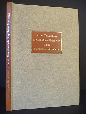
Atlas Geogr�fico, Estad�stico e Hist�rico de la Republica Mexicana
Published by Banco Nacional de Obras y Servicios P�blicos, S. N. C., Miguel �ngel Porr�a Librero-Editor, M�xico,, 1988
Book
Encuadernaci�n de tapa dura. Condition: Muy Bien. Primera edici�n facsimilar del edici�n pr�ncipe del a�o 1858. 33 cartas en estuche. Estuche original en tela. 57cms x 37cms. Estuche incluye: 2h. + 22h. + 3h. + 33 cartas + 14h. Texto en buen estado. Incluye 33 cartas con mapas. Edici�n de 1.400 ejemplares estuvo al cuidado de Miguel �ngel Porr�a.
-
Synodicon Hispanum. Vol. 1 bis 7.
Published by Madrid : Biblioteca de Autores Cristianos 1981-1997., 1981
Book
Gr.-8�, Hardcover. Koll. Sieben B�nde. Mehrb�ndiges ehemaliges Bibliotheksexemplar mit Stempeln und R�ckensignaturen. Einb�nde mit leichten Lagerspuren, Papier tlw. etwas nachgedunkelt, Seiten fest und textsauber. Dem Alter entsprechend sehr guter Zustand. GI3155, g�-mbx-g Altersfreigabe FSK ab 0 Jahre Sprache: Spanisch Gewicht in Gramm: 6650.
-

Memoria para servir a la Carta General de la Republica Mexicana.
Published by Imprenta de Andrade y Escalante, Mexico, 1861
Seller: Jeffrey H. Marks, Rare Books, ABAA, Rochester, NY, U.S.A.
Seller Rating:
First Edition
166 [1, Erratas] pp. Large folding map; one folding plate. 8vo, old quarter calf over boards. First edition. Boards rubbed and corners rounded; contents very nice.
-
Atlas Geogr�fico Esatd�stico e Hist�rico de la Rep�blica Mexicana (Facs�mil)
Published by Celanese Mexicana, 1982
Book
Encuadernaci�n de tapa dura. Condition: Muy bien. Facs�mil de la Edici�n de 1859. Formado por A. Garc�a y Cubas. Introducci�n: Graciela Romand�a de Cant�. Mexico. Contenidos: "Noticia de minerales y fincas r�sticas que, existen en la rep�blica mexicana, formada en vista a los datos mas recientes, para el Atlas geogr�fico, estad�stico e hist�rico de la misma rep�blica". "Noticia cronol�gica de los reyes anteriores a la conquista y gobernantes que han habido desde aquella �poca hasta nuestros d�as". "Carta general de la rep�blica mexicana." "Cuadro geogr�fico y estad�stico". Estado mexicanos. Tapas originales en plena tela. Bordes de tapas y lomo con muy leve desgaste. 30x44,5.
-
Atlas Geografico Estadistico e Historico de la Republica Mexicana, (The scarce 1982 Facsimile)
Published by Celanese Mexicana, Mexico, 1982
Book
Hardcover. Condition: Fine. Dust Jacket Condition: No Jacket as Issued. Elephant Folio, (17 3/4" X 12"). Spanish language only. Hardcover bound in burlap type cloth with leather paste down titles on the front board and spine. Illustrated with 30 double page colored maps and surrounding descriptions of states and territories in Mexico. Includes two additional double plates of history of the Aztec people. This is a magnificent facsimile of the rare 1858 edition which was the first atlas of Mexico written by a Mexican and printed in Mexico. In near fine condition, no former owner's names or marks. This facsimile is very scarce in its own right. Will require extra postage because of the very large size and weight.
-
Atlas Geografico de los Estados Unidos Mexicanos. Obra compuesta de 30 cartas de los estados, Distrito Federal y Territorios de la Baja California y Tepic
Published by Cadena y Ca, Mexico, 1897
Seller: Karol Krysik Books ABAC/ILAB, IOBA, PBFA, Toronto, ON, Canada
Association Member: ABAC ILAB IOBA PBFA
Seller Rating:
Leather. Condition: Very Good. Folio. [533 x 355mm]. Regional atlas with 30 double-page chromolithograph maps. Each with a thick silver border dated 1897. Bound in full brown leather with silver lettering right on the leather. The leather a little rubbed at the corners and heavily sunned at the upper and lower edges of the front board and the spine, boards a little scratched but the leather is still supple and the binding tight. Front and rear blanks affected by some damp staining just at the upper edges, rather light at the front but heavier at the rear, with the final map being affected but only near the very edges. A few occasional short rips, only two which touch maps, the rest within the wide margins, but not bad overall. Offered without the text volume.
-
Atlas geogr�fico de los Estados Unidos Mexicanos. Obra compuesta de 30 cartas de los Estados Unidos. Distrito federal y territorios de la Baja California y Tepic.
Published by Cadena y Compania, 1897
Book
Hardcover. Condition: Very Good. Mexico: Cadena y Ca., 1897. Folio. (28 5/8" x 14", 525mm x 360mm.) With double-page pictorial title page printed in red and black, and 30 double-page chromolithograph maps with wide silver boarders. Bound in red half sheep over red paper boards. On the spine, 5 raised bands with title and author gilt to the second panel and date gilt to the fourth. Extremities, spine and hinges heavily worn. Front and back boards stained and scratched. Minor tears to first 3 leaves and lower recto of first 15 leaves. Damp stains and oxidation of the silver throughout. With the letterpress bookplate of Maria del C(armen?) Cejudo laid in loose, with initials manuscript recto, and "24" and "20" manuscript to the verso. Antonio Garcia y Cubas (1832-1912) was a Mexican geographer, historian, author and cartographer. At age 14, he was struck by the the United States' invasion and occupation of his country. He became a civil servant, working for the Secretar�a de Fomento (Ministry of Development). The great detail and fine workmanship of his maps reflect the development of Mexican geography and the achievement of fine lithography in 19th century Mexico. The map of the Federal District is unique with its decoration of 8 vingnettes of floor plans. Several of the maps have insets, such as Sinaloa with "Mazatl�n.".
-
Atlas Geogr�fico de los Estados Unidos Mexicanos: Obra compuesta de 30 cartas de los estados, Distrito Federal y territorios de la Baja California y Tepic
Published by Mexico: Cadena y Ca., 1897., 1897
Folio (21 x 14 inches). 30 double-page chromolithograph regional maps of Mexico, each within broad silver border and fully colored, each map with integral finger tab titled in contemporary manuscript (title-page excised, quite browned). Contemporary half brown sheep, black cloth, gilt (very worn). Provenance: Contemporary ink stamp of G. �guila on verso of each map; with Dorothy Sloan, December 11th, 2009, lot 16 Exceptionally rare, in any condition, first published in 1886 by Debray under the same title, but with the addition of the silver borders which obscure the original 1886 title and imprint that are part of the original plate. Only two copies recorded on OCLC: UT Austin (Benson) and Getty. Each regional map is very detailed, with a key to towns, haciendas, ranchos, mines, anchorages, roads, and railroads, waterways, lakes, soundings, and mountain ranges. The map of the Federal District is decorated with eight vignettes showing floor plans of several buildings, Mexico City in pre-Hispanic times, a modern street plan, and Mexican antiquities. Several of the maps also have insets, such as the one of Guerrero, which has an inset of the "Puerto de Acapulco," and Sinaloa, with an inset of "Mazatl�n." Recent realignments of state borders are labelled and shown in red (e.g. Nuevo Le�n). "This atlas is emblematic of the progress and development in Mexico during Porfirio D�az s tenure as President. One such feature, for example, is the depiction of railroads, either existing or under consideration. As the map of Oaxaca shows, the elusive cross-Tehuantepec road is still "en estudio"; by contrast, Puebla is well served at this time by railways both public and private. The fine details of each map and the excellent workmanship reflect not only progress in defining and developing Mexico s geography but also embody the height of late nineteenth-century Mexican lithographic art" (Dorothy Sloan). Palau 98722. Phillips, Atlases 2687. Rumsey 5758. For more information about these maps, or a warm welcome to see them and other books in our library at 72nd Street, NYC, please contact Kate Hunter, M.A. Oxon, in the Rare Book Department.
-
Atlas Geografico, Estadistico � Historico de la Republica Mexicana.
Published by Mexico: Imprenta de Jos� Mariano Fernandez de Lara, 1858., 1858
First Edition
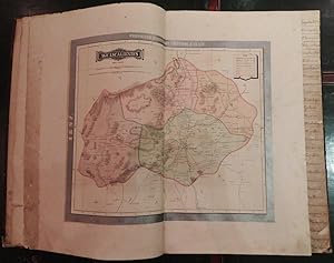
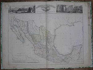
"Folio, (22 � x 15 inches). 28 fine double-page lithographed maps, with original hand-color in part; 2 maps from Mesoamerican pictorial manuscripts, one of which is hand-colored (occasional staining and spotting). Modern quarter black calf, marbled boards, gilt-lettered spine. "The first great atlas of Mexico, produced by a Mexican and printed in Mexico. Sabin says only 300 copies were printed" (Rumsey). First edition. Map 1 "Carta General Reducida," Map 17 "Mexico (Valle y Distrito de)," and Map 19 "Veracruz" not present. The general map of the republic of Mexico showing the boundaries created by the treaty of Guadeloupe Hidalgo of 1848 and the Gadsden Purchase of 1853. This is the first official map of Mexico, printed in Mexico and prepared from Mexican sources. 27 maps of states and territories surrounded by letterpress: Sonora, Chihuahua, Coahuila, Nuevo Leon, Tamaulipas, San Luis Potosi, Zacatecas, Aguascalientes, Durango, Sinaloa, Jalisco, Guanajuato, Mexico, Michoacan, Queretaro, Puebla, Guerrero, Oaxaca, Chiapas, Tabasco, Yucatan, Baja California, Colima, Tlaxcala, Tehuantepec, Territorios de Sierragorda, and Isla del Carmen. A few of the maps in this copy are misnumbered or bound out of order with respect to the Table of Contents. " [T]he SMGE's new national map, hastily finished in the aftermath of the War and during the initial phases of the boundary demarcation, appeared in 1850 It included a visual elaboration of the territory lost in the Treaty of Guadalupe-Hidalgo, as well as a demarcation of the new international limits between Mexico and the United States [According to Garcia Cubas in his 'El Libro de mis recuerdos' (p.452)], the image brought an expression of bitterness from General Santa Anna, who for the first time could actually envision the magnitude of the territory Mexico had lost. The map never saw publication because of the government's precarious financial condition after the war. Members of the Comision and [SMGE] sought publishers in the United States and England, but found the prices for publication no more accommodating than Mexico "The need for a published and circulated, Mexican-produced, national map became even more pronounced when in 1854, Mexico lost another portion of its territorial claim as a result of errors in the Disturnell map. . . . Regardless of the role General Antonio Lopez de Santa Anna and others played in the politics of the [Gadsden] Purchase, Mexican officials and intellectuals were convinced: Mexico needed an accurate and internationally accepted map of its own, published and circulated. "After the war, a new Carta General, constructed by Garcia Cubas, would proffer an iconographic image of the state's new parameters and fill that territory with the ghosts of the past, in the process creating an image of a single national spirit" (Craib, "Cartographic Mexico," pp. 25-27).".
-
Atlas geografico e historico de la Republica Mexicana, Formado por Antonio Garcia y Cubas
Published by Mexico: Imprenta de Jose Mariano Fernandez de Lara, Calle de la Palma numero 4, 1858., 1858
"Folio (21 6/8 x 15 inches). 31 double-page litographed maps all with original hand-colour in part, or in outline, and 2 maps from Mesoamerican pictorial manuscripts, one of which is hand-coloured. Contemporary red calf backed marbled paper boards, vellum corners, gilt (a bit worn at the extremities). Provenance: with the manuscript ownership inscription of the Hackley Public Library on the verso of the title-page and inialled on the verso of each map, with their later book plates and other labels on the front paste-down. "The first great atlas of Mexico, produced by a Mexican and printed in Mexico. Sabin says only 300 copies were printed" (Rumsey). 2 general maps of the republic of Mexico, showing the boundaries created by the treaty of Guadeloupe Hidalgo of 1848 and the Gadsden purchase of 1853, and 29 maps of states and territories surrounded by letterpress: Sonora, Chihuahua, Coahuila, Nuevo Leon, Tamaulipas, San Luis Potosi, Zacatecas, Aguascalientes, Durango, Sinaloa, Jalisco, Guanajuato, Michoacan, Queretaro, Mexico (very spotted), Valle de Mexico, Puebla, Veracruz, Guerrero, Oaxaca, Chiapas, Tabasco, Yucatan, Baja California, Colima, Territorios de Sierragorda e Isla del Carmen, Tlaxcala, Tehuantepec. Garcia y Cubas was one of Mexico's greatest cartographers, "el fundador de nuestra geograf�a como ciencia" (Dicc. Porr�a) who published the first comprehensive atlas of Mexico (Atlas, Geographico, Estadistico e Historico de la Republica Mexicana) in 1858. " [T]he SMGE s new national map, hastily finished in the aftermath of the War and during the initial phases of the boundary demarcation, appeared in 1850 It included a visual elaboration of the territory lost in the Treaty of Guadalupe-Hidalgo, as well as a demarcation of the new international limits between Mexico and the United States [According to Garcia Cubas in his El Libro de mis recuerdos (p.452)], the image brought an expression of bitterness from General Santa Anna, who for the first time could actually envision the magnitude of the territory Mexico had lost. The map never saw publication because of the government s precarious financial condition after the war. Members of the Comision and [SMGE] sought publishers in the United States and England, but found the prices for publication no more accommodating than Mexico "The need for a published and circulated, Mexican-produced, national map became even more pronounced when in 1854, Mexico lost another portion of its territorial claim as a result of errors in the Disturnell map. . . . Regardless of the role General Antonio Lopez de Santa Anna and others played in the politics of the [Gadsden] Purchase, Mexican officials and intellectuals were convinced: Mexico needed an accurate and internationally accepted map of its own, published and circulated. "After the war, a new Carta General, constructed by Garcia Cubas, would proffer an iconographic image of the state s new parameters and fill that territory with the ghosts of the past, in the process creating an image of a single national spirit" (Craib, "Cartographic Mexico," pp. 25-27). Catalogued by Kate Hunter".
-
Atlas Geografico, Estadistico e Historico de la Republica Mexicana
Published by Imprenta de Jose Mariano de Lara, Mexico, 1858
Seller: Heritage Book Shop, ABAA, Beverly Hills, CA, U.S.A.
Seller Rating:
First Edition Signed
First edition of the first atlas of Mexico written by a Mexican and printed in Mexico. Folio (21 3/4 x 14 3/4 inches; 553 x 370 mm.). 18, [2], [4], [2] pp. plus all thirthy-three double-page hand-colored ltihoragph maps and plates (one of the double-page spreads is comprised of two of the maps listed). Contemporary quarter brown morocco over marbled boards, spine with gilt lettering and devices. Small and old paper label on upper front cover. Small stamp on upper blank margin of title page (not offensive). Sinaloa plate browned. Some minor foxing but over all a wonderful copy of the first great scientific atlas of all of Mexico. This early lithographed atlas of Mexico includes the work of Mexican pioneer lithographers Iriarte, Decaen, and Salazar. The illustrations are signed "Mu� ozguren" and come from the lithographic shop of Iriarte & Cia., while the letterpress typography is by Lara. The atlas was created during the Golden Age of Mexican lithography (see Mathes, Mexico on Stone, pp. 17-32). The design and execution of the atlas are handsome, with the middle of each double-page spread being occupied by the map of a specific state or territory, surrounded by statistical and historical information about the region, including subjects of borderlands interest, such as Native American tribes and incursions. The large and fine general map of Mexico by Salazar is one of the finest maps of Mexico created in the nineteenth century, with a spirited Mexican eagle atop cactus at top center, and especially beautiful lithographed views on either side (Popocatepetl, Orizava, Cascada de Regla, Palenque, Mitla, Uxmal, etc.). The maps of the states that border with the United States are especially interesting for clearly delineating the changing boundaries over time. For instance, the map of Sonora shows the demarcation of the Treaty of Mesilla in 1853 (Gadsden Purchase). The map of Chihuahua shows the boundary line before and after the Gadsden Purchase. The Tamaulipas map shows the new boundary at the Rio Grande, as well as the older line of demarcation at the Nueces. The plates from Mapa Sig�enza and C�dice Boturini are accompanied by the notes of Jos� Fernando Ram�rez of the Museo Nacional. Palau 98721. Phillips, Atlases, 2683. Sabin 26554. HBS 66945. $10,000.