Order Total (1 Item Items):
Shipping Destination:

Greenleaf, Jeremiah 1791 1864 (2 results)
Skip to main search results
Product Type
- All Product Types
- Books (2)
- Magazines & Periodicals
- Comics
- Sheet Music
- Art, Prints & Posters
- Photographs
- Maps
-
Manuscripts &
Paper Collectibles
Condition
- All Conditions
- New
- Used
Binding
- All Bindings
- Hardcover
- Softcover
Collectible Attributes
- First Edition
- Signed
- Dust Jacket
- Seller-Supplied Images (1)
- Not Printed On Demand
Free Shipping
Seller Location
Seller Rating
-
A NEW UNIVERSAL ATLAS; COMPRISING SEPARATE MAPS OF ALL THE PRINCIPAL EMPIRES, KINGDOMS, & STATES THROUGHOUT THE WORLD AND FORMING A DISTINCT ATLAS OF THE UNITED STATES. A NEW EDITION, REVISED AND CORRECTED TO THE PRESENT TIME.
Published by Brattleborough VT: G. R. French, 1842
Book
Hardcover. Condition: Very Good. No Jacket. 2nd Edition. Folio, contemporary (likely original) 3/4 polished calf, cloth covers with mounted, brilliant gilt stamped red morocco label ("E. W. CARRINGTON | THE UNIVERSAL ATLAS | FARMINGTON"), thick marbled endpapers, title page, Contents leaf, 65 maps, all hand-colored (mostly in soft pink, yellow & green), with but one or two small spots detected. Otherwise, clean and bright throughout. Of these, 37 are devoted to North America. Of some rarity, despite the fact that two other examples are currently (1/24) on offer on various platforms, and priced somewhat in advance of the present, superior specimen. My cursory scan through the final four decades of lists published by Ken Leach, of Brattleboro VT - a man always keenly connected to rare and desirable Vermontiana - revealed but one copy he had on offer, back in 1984, for a tenth the price of this one. AMERICAN IMPRINTS 42-2111. NOT IN GILMAN. Only Edition. A Very Good copy.
-

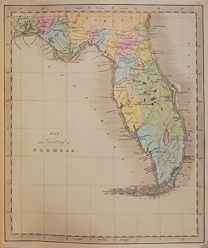
Folio (14 4/8 x 12 inches). Engraved title-page, Contents leaf, and 65 engraved maps, all with original hand-colour in full (some spotting to text leaves, one or two pale stains). Original half calf, brown cloth, red morocco lettering-piece on the front cover (worn and stained). First published in 1840, based on David H. Burr's "Universal Atlas" of 1836. This atlas contains the rare fine large-scale map of Texas "Texas Compiled from the Latest and Best Authorities". Greenleaf's map is an early map to show the individual counties, each colored. Two other maps in the atlas are of Texas interest: "North America", shows Texas as an independent republic; as does "The United States of Mexico". Streeter very famously did not include this atlas in his collection because: "Examples of atlas maps not separately published, and so not included, are Texas from the Latest Authorities, scale about seventy miles to the inch, found in the 1842 Greenleaf Atlas" (Streeter, Texas, volume III, page 330). Other maps of interest include the four hemispheres of the world, a "Map of the Country Twenty-Five Miles Round the City of New York", which is also circular; and "New Holland and New Zealand";.Day, Maps of Texas, p. 22. Phillips, America, p. 843; Atlases 784.