Order Total (1 Item Items):
Shipping Destination:

Kitchin, Thomas 1719 1784 (3 results)
Skip to main search results
Product Type
- All Product Types
- Books (2)
- Magazines & Periodicals
- Comics
- Sheet Music
- Art, Prints & Posters
- Photographs
- Maps (1)
-
Manuscripts &
Paper Collectibles
Condition
- All Conditions
- New
- Used
Binding
- All Bindings
- Hardcover (1)
- Softcover
Collectible Attributes
- First Edition
- Signed
- Dust Jacket
- Seller-Supplied Images (1)
- Not Printed On Demand
Free Shipping
Seller Location
Seller Rating
-
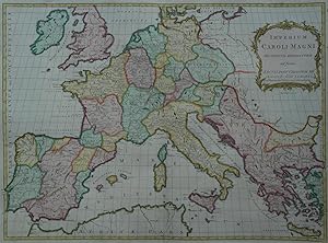
Kein Einband. Condition: Sehr gut. Es handelt sich hierbei um eine originale, kolorierte Kupferstich-Landkarte des Frankenreichs unter Karl dem Gro�en von Thomas Kitchen f�r John Blair aus dem Jahr 1799. *** Titel: Imperium Caroli Magni *** Gebiet bzw. Ort: Das Frankenreich unter Karl dem Gro�en *** Kartograph: Thomas Kitchin (1719 - 1784), Ausgabe bei John Blair Jahr: 1799 *** Gr��e des Plattenbereichs: 47 x 60 cm *** Technik: Kupferstich *** Zustand (Perfekt/ Sehr gut/ Gut/ Ordentlich/ M��ig/ Schlecht): In sehr gutem Erhaltungszustand. *** Bemerkungen: Diese seltene, gro�formatige Karte in dekorativem Kolorit zeigt das Frankenreich unter Karl dem Gro�en* zur Zeit seiner gr��ten Ausdehnung. Die Karte wurde von Thomas Kitchen entworfen und entstammt John Blairs "Chronological History of the World", dessen Erstausgabe in London 1754 erschien. --- * Karl der Gro�e (lateinisch Carolus Magnus oder Karolus Magnus, franz�sisch und englisch Charlemagne; * wahrscheinlich 2. April 747 oder 748;[1] 28. Januar 814 in Aachen) war von 768 bis 814 K�nig des Fr�nkischen Reichs (bis 771 gemeinsam mit seinem Bruder Karlmann). Er erlangte am 25. Dezember 800 als erster westeurop�ischer Herrscher seit der Antike die Kaiserw�rde, die mit ihm erneuert wurde. Der Enkel des Hausmeiers Karl Martell war der bedeutendste Herrscher aus dem Geschlecht der Karolinger. Das Frankenreich gelangte unter ihm zu seiner gr��ten Ausdehnung und Machtentfaltung. (Wikipedia) - - - International buyers welcome. If you have any questions, please don't hesitate to ask. --- Auf Wunsch stellen wir Ihnen gerne ein kostenfreies Echtheitszertifikat aus --- If you wish, we will gladly provide a certificate of authenticity free of charge ---.
-

The Chronology and History of the World, from the Creation to the Year of Christ, 1768
Published by London: 1768., 1768
Folio (18 x 11 4/8 inches). Letterpress preliminaries and Index at end. Engraved title-page with vignette, dedication leaf, 56 mostly double-page leaves of chronology, and 14 double-page and folding maps of the ancient and modern world engraved by Thomas Kitchin (some offsetting). Contemporary tree calf (rebacked, scuffed). Provenance: early marginal annotations; engraved armorial bookplate of T. Bigelow Lawrence on the front paste-down. First published without maps in 1756. The maps related to America are "A Map of the West Indies and Middle Continent of America" showing the Gulf of Mexico and the Caribbean, with many forts and towns named. The British colony of Georgia extends to the Mississippi River and the Gulf Coast and its boundary with Florida is noted as Limits Stipulated 1738, leaving the Spanish colony of Florida occupying only the peninsula. A line further south is noted as the Southern Bounds [Georgia] by Charter 1665. The southern portion of Florida is shown as a collection of large islands, named Bay del Spiritu Santo. Texas is named as the New Kingdom of Leon. "A Map of North America from the Latest Surveys and Maps" shows the continent during the transitional period leading up to the American Revolution. The map shows much of the region controlled by the British after the French and Indian War. Several of the colonial charters show their boundaries extending to an indeterminate western boundary. The charter and dates are noted along the colonial boundaries, which extend through Louisiana, a Spanish possession at the time this map was made. Another important boundary is New Mexico's eastern line, which travels north along the R. Mexicano (Sabine River) before turning northwest where it intersects with North Carolina's southern border. Another important map is that of the East-Indies showing southeast Asia depicting India at a time when Britain and the East India Company were solidifying control of the subcontinent. Catalogued by Kate Hunter.
-
A General Atlas, describing the Whole Universe.
Published by London: Robert Sayer and J. Bennett, [1782-1787]., 1787
Folio (21 x 15 2/8 inches). Letterpress title-page (spotted). 23 engraved maps on 35 mapsheets with original hand-colour in outline (some mostly marginal spotting and light soiling, occasional offsetting). Modern half calf, over contemporary marbled paper boards (boards rubbed). Provenance: with the early 19th-century ownership inscription of H. Hamilton, Blackburn Cottage at the head of the title-page; Forster family; acquired from Lepe House, by Christopher Henry Beaumont Pease, Lord Wardington (1924-2005), Library of Important Atlases and Geographies, his sale Sothebys' 10th October 2005, lot 240. One of the first atlases to reflect the many boundary changes resulting from the Peace of Versailles after it had been fully accepted by Britain and the other European powers, as well as the United States. Several maps can be joined to form large wall maps. The atlas was originally compiled by Thomas Jeffreys and first published in 1773, after his bankruptcy, by Robert Sayer as Sayer's first terrestrial atlas. Subsequently, Sayer, and from 1794 his successors Laurie and Whittle, reprinted or reissued the atlas almost annually. From the distinguished library of Lord Wardington whose collection of Atlases was unique: "a panoply of the history of cartography and of great mapmakers" (Andrew Phillips "An Appreciation", Sotheby's sale catalogue). Phillips 667 and 3522. Catalogued by Kate Hunter (L64F8G).