
Order Total (1 Item Items):
Shipping Destination:

Reinecke, I C (11 results)
Skip to main search results
Product Type
- All Product Types
- Books (1)
- Magazines & Periodicals
- Comics
- Sheet Music
- Art, Prints & Posters (7)
- Photographs
- Maps (3)
-
Manuscripts &
Paper Collectibles
Condition
- All Conditions
- New
- Used
Binding
- All Bindings
- Hardcover
- Softcover
Collectible Attributes
- First Edition
- Signed
- Dust Jacket
- Seller-Supplied Images (7)
- Not Printed On Demand
Seller Location
Seller Rating
-
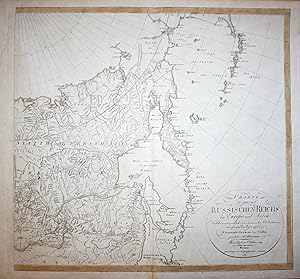
Charte des ganzen Russischen-Reichs in Europa und Asien" - Russia Russland Kamtchatka Asia Asien Karte map
Published by Weimar, 1817
Seller: Antiquariat Steffen V�lkel GmbH, Seubersdorf, Germany
Seller Rating:

Map
Original Kupferstich-Kartevon 1817. Rechte h�lfte einer zweibl�ttringen Karte von Russland. -- Blattmasse: ca. 60 x 53 cm -- gut erhalten. || Original copper engraved map from 1817. The right half of a two-sheet map of Russia. -- in good condition. || Dies ist ein Original! - Kein Nachdruck! - Keine Kopie! -- This is an original! No copy! - No reprint! Sprache: Deutsch Gewicht in Gramm: 1500.
-

Charte Von Schweden Und Norwegen
Published by Geogr. Instituts, Weimar, 1822
Condition: Good. Handcolored map of this Scandinavian region; German language; map darkened, some edge, tips wear, a little splitting along old fold lines at edge; decent margins, 23 1/4" x 29" overall size; has been rolled for some time; good condition overall.
-
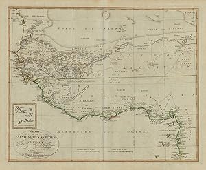
Charte von Senegambien, Nigritien und Guinea, Nach den neuesten See- und Land-Reisen und astronomischen Beobachtungen gezeichnet von I.C.M. Reinecke. Weimar Im Verlage des Geographischen Instituts. Revidiert im September 1804.
Published by Geographisches Institut, Weimar, 1804
Seller: Antiquariat Reinhold Berg eK Inh. R.Berg, Regensburg, Germany
Seller Rating:

Map
Other. Copper engraving, hand colored in outline and wash when published. In excellent condition. 440 by 542mm (17� by 21� inches). 440 by 542mm (17� by 21� inches).
-
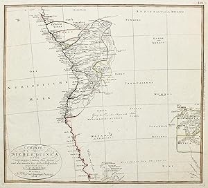
Nieder Guinea.
Published by Weimar,, 1804
Seller: libreria antiquaria perini Sas di Perini, Verona, VR, Italy
Seller Rating:
Art / Print / Poster
Incisione in rame, dipinta d'epoca, mm. 458x490. Tratta da Algemeiner Hand-Atlas der Ganzen Erde.di Adam Christian Gaspari, opera pubblicata a partire dal 1797, che poi ebbe varie edizioni ampliate nel XIX secolo. Buon esemplare con leggerissima traccia di umidit? al margine destro. Nr.cat: 100_6857.
-
Charte der Laender am Caucasus.
Published by Weimar,, 1804
Seller: libreria antiquaria perini Sas di Perini, Verona, VR, Italy
Seller Rating:
Art / Print / Poster
Incisione in rame, grande carta geografica dipinta d'epoca ai confini, entro riquadro e cartiglio esplicativo; mm. 460x570. Tratta da Algemeiner Hand-Atlas der Ganzen Erde.di Adam Christian Gaspari, opera pubblicata a partire dal 1797, che poi ebbe varie edizioni ampliate nel XIX secolo. Buon esemplare a pieni margini su carta azzurrata, che presenta minimo lieve alone solo marginale, due piccoli fori.
-
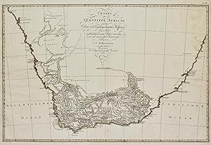
Suedspitze Africa.
Published by Weimar,, 1804
Seller: libreria antiquaria perini Sas di Perini, Verona, VR, Italy
Seller Rating:
Art / Print / Poster
Incisione in rame, dipinta d'epoca, mm. 397x604. Tratta da Algemeiner Hand-Atlas der Ganzen Erde.di Adam Christian Gaspari, opera pubblicata a partire dal 1797, che poi ebbe varie edizioni ampliate nel XIX secolo. Buon esemplare con leggere tracce di umidit? al margine destro. Nr.cat: 100_6856.
-
Island.
Published by Weimar, 1804
Seller: libreria antiquaria perini Sas di Perini, Verona, VR, Italy
Seller Rating:
Art / Print / Poster
Incisione in rame, dipinta d'epoca ai confini, mm. 485x555. Tratta da Algemeiner Hand-Atlas der Ganzen Erde.di Adam Christian Gaspari, opera pubblicata a partire dal 1797, che poi ebbe varie edizioni ampliate nel XIX secolo. Buon esemplare con alone circoscritto al margine inferiore.
-
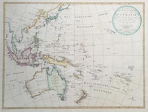
General-Charte von Australien. Nach den neuesten Entdeckungs-Reisen und astronomischen Bestim(m)ungen neu entworfen und gezeichnet. Revidirt im April 1806.
Published by Weimar: Geogr. Institut dat. ,, 1806
Seller: Antiquariat Ruthild J�ger, Lueneburg, Germany
Seller Rating:

Art / Print / Poster
Grenzkolorierter Kupferstich, 61 x 46 cm. Breitrandig, sehr gut erhalten. In very good condition, with wide margins. * Tooley, Australia 1001. Eine der fr�hen Australien-Karten (erstmals 1801 erschienen), die bereits fast vollst�ndig die K�stenkonturen zeigt (eine L�cke nur noch in der Region der sp�ter gegr�ndeten Stadt Adelaide). Das Kartenbild reicht bis Indonesien, Philippinen, Sandwich-Islands (Hawaii), Gesellschafts-Inseln, Pitcairn, Tasmania (Van Diemens Land) und Neuseeland. Australien ist unterteilt in "Neu Holland" (Westen) und "Neu S�d Wallis" (Osten) Oben rechts runde Titelkartusche mit Autoren- und Verlagsangabe. An den K�sten Australiens sind erste geographische Erkenntnisse eingraviert: "Hohe rote Spitze", "Unfruchtbares Land", "Unbewohnte wasserlose Gegend", "D�rres Land mit einzelnen B�umen", "Geographen-Bay", "Nuyt's Entdeckung" (=Nullarbor Plain), "Dreyeinigkeits-Berg" (bei Cape Tribulation), "Warnungs-Berg" und "Spitze der Gefahr" etc. One of the earliest special maps of Australia. In the coast regions are engraved many short mentions about the unhabitated waterless landscape, unfertile soil, dry lands with lone trees, etc. The whole of the south coast is filled in. . The shape of New Guinea is completely altered. (T.). 2nd edition (first publ. 1801). (#4981AG) Sprache: Deutsch.
-
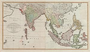
Charte von Ostindien Diesseits und Jenseits des Ganges nach den neuesten astronom. Beobachtungen auch andern sichern H�lfsmitteln neu entworfen und nach der lezten Zertheilung des Mysorischen Reichs berichtiget von I.C.M. Reinecke. Weimar im Verlage des Geograph. Instituts. revidirt im Aug. 1804.
Published by Geographisches Institut, Weimar, 1804
Seller: Antiquariat Reinhold Berg eK Inh. R.Berg, Regensburg, Germany
Seller Rating:
Map
Other. Copper engraving, hand colored in outline and wash when published. In excellent condition. 471 by 860mm (18� by 33� inches). 471 by 860mm (18� by 33� inches).
-
Charte von Ost Indien diesseits und jenseits des Ganges.
Published by Weimar, 1804
Seller: libreria antiquaria perini Sas di Perini, Verona, VR, Italy
Seller Rating:
Art / Print / Poster
Incisione in rame, dipinta d'epoca, su due tavole separate, misura complessiva mm. 490x900. Tratta da Algemeiner Hand-Atlas der Ganzen Erde.di Adam Christian Gaspari, opera pubblicata a partire dal 1797, che poi ebbe varie edizioni ampliate nel XIX secolo. Buon esemplare con leggere tracce di umidit? ai margini. Nr.cat: P1270007.
-

Charte des ganzen Russischen-Reichs in Europa und Asien.
Published by Weimar, 1804
Seller: libreria antiquaria perini Sas di Perini, Verona, VR, Italy
Seller Rating:
Art / Print / Poster
Incisione in rame, dipinta d'epoca ai confini, su due tavole separate, misura complessiva mm 520x1095. Tratta da Algemeiner Hand-Atlas der Ganzen Erde.di Adam Christian Gaspari, opera pubblicata a partire dal 1797, che poi ebbe varie edizioni ampliate nel XIX secolo. Buon esemplare. Nr.cat: 6416.
