
Order Total (1 Item Items):
Shipping Destination:

S Augustus Mitchell Jr (314 results)
Skip to main search results
Product Type
- All Product Types
- Books (313)
- Magazines & Periodicals
- Comics
- Sheet Music
- Art, Prints & Posters
- Photographs
- Maps
-
Manuscripts &
Paper Collectibles (1)
Condition
Binding
Collectible Attributes
- First Edition (3)
- Signed
- Dust Jacket
- Seller-Supplied Images (307)
- Not Printed On Demand (313)
Free Shipping
Seller Location
Seller Rating
-

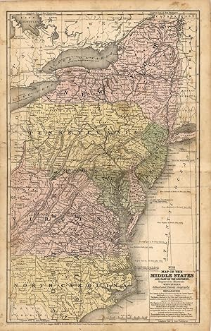
Soft cover. Condition: Very Good. W. H. Gamble (illustrator). Hand-colored map 14" x 11 1/2". Horizontal fold, Small splits margins of center fold; no foxing or soiling. Book.
-
Map of South America, Showing Its Political Divisions [with inset] Map Showing the Proposed Atrato-Inter-Oceanic Canal Routes for Connecting the Atlantic and Pacific Oceans [verso with] Map of New Granada, Venezuela and Guiana [and] Map of Peru, and Equador [and] Map of the Argentine Confederation
Published by W.M. Bradley, Philadelphia, 1886
Seller: Kaaterskill Books, ABAA/ILAB, East Jewett, NY, U.S.A.
Association Member: ABAA ILAB IOBA
Seller Rating:

Hand colored map. Plate 103: Map of South America, Showing Its Political Divisions, with inset of Map Showing the Proposed Atrato-Inter-Oceanic Canal Routes for Connecting the Atlantic and Pacific Oceans. Constructed & Engraved by W. Williams, Philadelphia. Copyright by S. Augustus Mitchell 1884. 12 x 9.25 inches. [On verso] Plate 104: Map of New Granada, Venezuela and Guiana (with) Map of Peru, and Equador (with) Map of the Argentine Confederation. Copyright by S. Augustus Mitchell 1884. 14 x 10.5 inches. From: Mitchell's New General Atlas, Containing Maps Of The Various Countries Of The World, Plans Of Cities, Etc., Embraced In Ninety-Three Quarto Maps, Forming A Series Of One Hundred and Forty-seven Maps and Plans, Together With Valuable Statistical Tables. Also, A List Of Post-Offices Of The United States And Territories, And Also Census Of 1880 For States, Territories And Counties, Also Of Cities Of Over 10,000 Inhabitants. Philadelphia: Published By Wm. M. Bradley & Bro., No. 1026 Arch Street. 1886. Very good, light browning and soiling, mostly to margins.
-
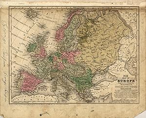
Map of Brazil, Bolivia, Paraguay, and Uruguay (with) Map of Chili [with inset] Harbor of Bahia [with inset] Harbor of Rio Janeiro [with inset] Island of Juan Fernandez [verso with] Map of Europe, Showing Its Gt. Political Divisions
Published by W.M. Bradley, Philadelphia, 1886
Seller: Kaaterskill Books, ABAA/ILAB, East Jewett, NY, U.S.A.
Association Member: ABAA ILAB IOBA
Seller Rating:
Hand colored map. Plate 105: Map of Brazil, Bolivia, Paraguay, and Uruguay with two insets of the Harbor of Bahia and the Harbor of Rio de Janeiro [with] Map of Chili, with inset of the Island of Juan Fernandez. Copyright 1886 by Wm. M. Bradley & Bro. 12 x 9.25 inches. [On verso] Plate 106: Map of Europe, Showing Its Gt. Political Divisions. Constructed & Engraved by W. Williams, Philadelphia. Copyright by S. Augustus Mitchell 1884. 13.75 x 11 inches. From: Mitchell's New General Atlas, Containing Maps Of The Various Countries Of The World, Plans Of Cities, Etc., Embraced In Ninety-Three Quarto Maps, Forming A Series Of One Hundred and Forty-seven Maps and Plans, Together With Valuable Statistical Tables. Also, A List Of Post-Offices Of The United States And Territories, And Also Census Of 1880 For States, Territories And Counties, Also Of Cities Of Over 10,000 Inhabitants. Philadelphia: Published By Wm. M. Bradley & Bro., No. 1026 Arch Street. 1886. Very good, faint soiling and browning, few closed edge tears.
-
Washington D.C. 1877 Plate, Single Page Hand Colored Map Reproduction of-Washington D.C. Washington D.C. 1877 15 X 13
Published by Historic Map Works, Freemont, ME, 2009
Condition: Fine. No dust jacket. U. S. Congress Augustus, Mitchell Jr. 1877 (illustrator). Reprint. Includes maps. Giclee Ink Jet Reproduction Map Done to Original Size 15 x 13 in Color on Special Matte Paper, NF-Fine. This is a full color reproduction done from the original map and at the size of the original from the Washington D.C. 1864 Mitchell Plate by U. S. Congress Augustus, Mitchell Jr. 1877.
-
![Seller image for [Map] Russia in Europe, Sweden, and Norway [with insets] Map of Denmark [and] Map of Holland and Belgium for sale by Kaaterskill Books, ABAA/ILAB](https://pictures.abebooks.com/inventory/md/md31156940494.jpg)
[Map] Russia in Europe, Sweden, and Norway [with insets] Map of Denmark [and] Map of Holland and Belgium
Published by [W.M. Bradley], [Philadelphia], 1886
Seller: Kaaterskill Books, ABAA/ILAB, East Jewett, NY, U.S.A.
Association Member: ABAA ILAB IOBA
Seller Rating:
Hand colored map. 13.75 x 10.5 inches. Plate 112. Russia in Europe, Sweden, and Norway, insets of Map of Denmark, and Map of Holland and Belgium. Copyright by S. Augustus Mitchell 1884. From: Mitchell's New General Atlas, Containing Maps Of The Various Countries Of The World, Plans Of Cities, Etc., Embraced In Ninety-Three Quarto Maps, Forming A Series Of One Hundred and Forty-seven Maps and Plans, Together With Valuable Statistical Tables. Also, A List Of Post-Offices Of The United States And Territories, And Also Census Of 1880 For States, Territories And Counties, Also Of Cities Of Over 10,000 Inhabitants. Philadelphia: Published By Wm. M. Bradley & Bro., No. 1026 Arch Street. 1886. Very good,minor soiling, one closed edge tear, not affecting contents.
-
[Map] Prussia, and the German States [verso with] Map of the Austrian Empire, Italian States. Turkey in Europe, and Greece [with inset] Maltese Islands
Published by [W.M. Bradley], [Philadelphia], 1886
Seller: Kaaterskill Books, ABAA/ILAB, East Jewett, NY, U.S.A.
Association Member: ABAA ILAB IOBA
Seller Rating:
Hand colored map. Plate 113: [Map] Prussia, and the German States. Copyright by S. Augustus Mitchell 1884. 13.5 x 10.5 inches. [On verso] Plate 114: Map of the Austrian Empire, Italian States, Turkey in Europe, and Greece, with inset Maltese Islands. Copyright by S. Augustus Mitchell 1884. 13.5 x 10.5 inches. From: Mitchell's New General Atlas, Containing Maps Of The Various Countries Of The World, Plans Of Cities, Etc., Embraced In Ninety-Three Quarto Maps, Forming A Series Of One Hundred and Forty-seven Maps and Plans, Together With Valuable Statistical Tables. Also, A List Of Post-Offices Of The United States And Territories, And Also Census Of 1880 For States, Territories And Counties, Also Of Cities Of Over 10,000 Inhabitants. Philadelphia: Published By Wm. M. Bradley & Bro., No. 1026 Arch Street. 1886. Entered . 1883, by S. Augustus Mitchell . Washington. Very good, few minor edge tears, light soiling and staining to margins.
-
![Seller image for [Map] Spain & Portugal for sale by Kaaterskill Books, ABAA/ILAB](https://pictures.abebooks.com/inventory/md/md31156940496.jpg)
[Map] Spain & Portugal
Published by [W.M. Bradley & Bro.], [Philadelphia], 1886
Seller: Kaaterskill Books, ABAA/ILAB, East Jewett, NY, U.S.A.
Association Member: ABAA ILAB IOBA
Seller Rating:
Hand colored map. 15 x 11.25 inches. Plate 111: Spain & Portugal. Copyright by Wm. M. Bradley & Bro. 1884. From: Mitchell's New General Atlas, Containing Maps Of The Various Countries Of The World, Plans Of Cities, Etc., Embraced In Ninety-Three Quarto Maps, Forming A Series Of One Hundred and Forty-seven Maps and Plans, Together With Valuable Statistical Tables. Also, A List Of Post-Offices Of The United States And Territories, And Also Census Of 1880 For States, Territories And Counties, Also Of Cities Of Over 10,000 Inhabitants. Philadelphia: Published By Wm. M. Bradley & Bro., No. 1026 Arch Street. 1886. Very good, closely cropped margins, light soiling.
-
This map was produced by S.A. Mitchell in 1878 for his New Intermediate Geography. The map is nicely hand water-colored. Soon after this time period all maps were mass produced using printed color plates. This map measures 8 inches by 11 inches.
-
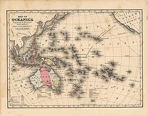
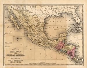
One of the dominant firms in 19th century cartography was unquestionably the Mitchell publishing company. While they had been producing fine quality maps and atlases since the 1830s, they also made instructional material that was up to date and accurate. This map comes from one of the early school atlases published by Mitchell, and contains a wealth of information, and attractive hand color. The condition is very good, with some mild staining, but mostly outside the image. This map measures 10.5 inches by 17 inches.
-
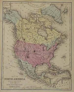
This map was produced by S.A. Mitchell in 1878 for his New Intermediate Geography. The map is nicely hand water-colored. Soon after this time period all maps were mass produced using printed color plates. This is a beautiful map of North America that includes the entire continent with Greenland, and the West Indies Islands. This map measures 10.5 inches by 8.25 inches.
-
This map was produced by S.A. Mitchell in 1878 for his New Intermediate Geography. The map is nicely hand water-colored. Soon after this time period all maps were mass produced using printed color plates. This map measures 10.75 inches by 8.25 inches.
-
![Seller image for A general view of the world, comprising a physical, political, and statistical account of its grand divisions . with their empires, kingdoms, republics, principalities, &c: exhibiting the history of geographical science and the progress of discovery to the present time. Illustrated by upwards of nine hundred engravings [LeatherBound] for sale by True World of Books](https://pictures.abebooks.com/inventory/md/md31534357250.jpg)
A general view of the world, comprising a physical, political, and statistical account of its grand divisions . with their empires, kingdoms, republics, principalities, &c: exhibiting the history of geographical science and the progress of discovery to the present time. Illustrated by upwards of nine hundred engravings [LeatherBound]
Publication Date: 2023
Book Print on Demand
LeatherBound. Condition: New. LeatherBound edition. Condition: New. Reprinted from 1842 edition. Leather Binding on Spine and Corners with Golden leaf printing on spine. Bound in genuine leather with Satin ribbon page markers and Spine with raised gilt bands. A perfect gift for your loved ones. NO changes have been made to the original text. This is NOT a retyped or an ocr'd reprint. Illustrations, Index, if any, are included in black and white. Each page is checked manually before printing. As this print on demand book is reprinted from a very old book, there could be some missing or flawed pages, but we always try to make the book as complete as possible. Fold-outs, if any, are not part of the book. If the original book was published in multiple volumes then this reprint is of only one volume, not the whole set. Sewing binding for longer life, where the book block is actually sewn (smythe sewn/section sewn) with thread before binding which results in a more durable type of binding. Pages: 850 Language: English.
-
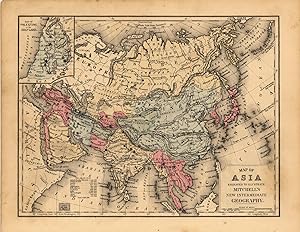
Map of Asia Showing its Gt. Political Divisions, and also the Various Routes of Travel Between London & India, China & Japan &c. [verso with] Map of Persia, Arabia, Turkey in Asia, Afghanistan, Beloochistan
Published by [W.M. Bradley], [Philadelphia], 1886
Seller: Kaaterskill Books, ABAA/ILAB, East Jewett, NY, U.S.A.
Association Member: ABAA ILAB IOBA
Seller Rating:
Hand colored map. Plate 115: Map of Asia Showing its Gt. Political Divisions, and also the Various Routes of Travel Between London & India, China & Japan &c, constructed & engraved by W. Williams, Philadelphia. Copyright by S. Augustus Mitchell 1884. 13.5 x 10.5 inches. [On verso] Plate 116: Map of Persia, Arabia, Turkey in Asia, Afghanistan, Beloochistan. Copyright by S. Augustus Mitchell 1884. 13.5 x 10.5 inches. From: Mitchell's New General Atlas, Containing Maps Of The Various Countries Of The World, Plans Of Cities, Etc., Embraced In Ninety-Three Quarto Maps, Forming A Series Of One Hundred and Forty-seven Maps and Plans, Together With Valuable Statistical Tables. Also, A List Of Post-Offices Of The United States And Territories, And Also Census Of 1880 For States, Territories And Counties, Also Of Cities Of Over 10,000 Inhabitants. Philadelphia: Published By Wm. M. Bradley & Bro., No. 1026 Arch Street. 1886. Very good, light soiling, primarily to margins.
-
![Seller image for County and Township Map of Utah and Nevada [with inset] Southern Portion of Nevada for sale by Kaaterskill Books, ABAA/ILAB](https://pictures.abebooks.com/inventory/md/md31156927733.jpg)
County and Township Map of Utah and Nevada [with inset] Southern Portion of Nevada
Published by [W.M. Bradley & Bro.], [Philadelphia], 1886
Seller: Kaaterskill Books, ABAA/ILAB, East Jewett, NY, U.S.A.
Association Member: ABAA ILAB IOBA
Seller Rating:
Condition: Very good, light soiling. Hand colored map. 22 x 14 inches. Plate 91: County and township map of Utah and Nevada. Inset: Southern portion of Nevada. Copyright by Wm. M. Bradley & Bro. 1884. From: Mitchell's New General Atlas, Containing Maps Of The Various Countries Of The World, Plans Of Cities, Etc., Embraced In Ninety-Three Quarto Maps, Forming A Series Of One Hundred and Forty-seven Maps and Plans, Together With Valuable Statistical Tables. Also, A List Of Post-Offices Of The United States And Territories, And Also Census Of 1880 For States, Territories And Counties, Also Of Cities Of Over 10,000 Inhabitants. Philadelphia: Published By Wm. M. Bradley & Bro., No. 1026 Arch Street. 1886.
-
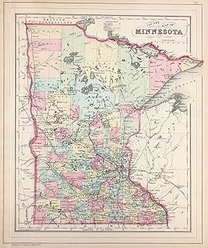
County Map of Minnesota
Published by [W.M. Bradley & Bro.], [Philadelphia], 1886
Seller: Kaaterskill Books, ABAA/ILAB, East Jewett, NY, U.S.A.
Association Member: ABAA ILAB IOBA
Seller Rating:
Condition: Very good, faint toning. Hand colored map. 11.5 x 13.75 inches. Plate 81: County Map of Minnesota. Copyright by S. Augustus Mitchell 1884. From: Mitchell's New General Atlas, Containing Maps Of The Various Countries Of The World, Plans Of Cities, Etc., Embraced In Ninety-Three Quarto Maps, Forming A Series Of One Hundred and Forty-seven Maps and Plans, Together With Valuable Statistical Tables. Also, A List Of Post-Offices Of The United States And Territories, And Also Census Of 1880 For States, Territories And Counties, Also Of Cities Of Over 10,000 Inhabitants. Philadelphia: Published By Wm. M. Bradley & Bro., No. 1026 Arch Street. 1886.
-

County and Township Map of Oregon and Washington
Published by [W.M. Bradley & Bro.], [Philadelphia], 1886
Seller: Kaaterskill Books, ABAA/ILAB, East Jewett, NY, U.S.A.
Association Member: ABAA ILAB IOBA
Seller Rating:
Condition: Very good, faint toning. Hand colored map. 20 x 14.5 inches. Plate 93: County and township map of Oregon and Washington. Copyright by Wm. M. Bradley & Bro. 1884. From: Mitchell's New General Atlas, Containing Maps Of The Various Countries Of The World, Plans Of Cities, Etc., Embraced In Ninety-Three Quarto Maps, Forming A Series Of One Hundred and Forty-seven Maps and Plans, Together With Valuable Statistical Tables. Also, A List Of Post-Offices Of The United States And Territories, And Also Census Of 1880 For States, Territories And Counties, Also Of Cities Of Over 10,000 Inhabitants. Philadelphia: Published By Wm. M. Bradley & Bro., No. 1026 Arch Street. 1886.
-
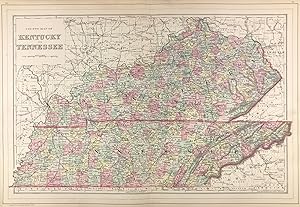
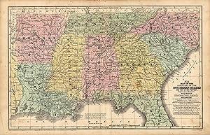
County Map of Kentucky and Tennessee
Published by [W.M. Bradley & Bro.], [Philadelphia], 1886
Seller: Kaaterskill Books, ABAA/ILAB, East Jewett, NY, U.S.A.
Association Member: ABAA ILAB IOBA
Seller Rating:
Hand colored map. 22 x 14 inches. Plates 50 & 51: County Map of Kentucky and Tennessee, drawn & engraved by W.H. Gamble, Philadelphia. Copyright by S. Augustus Mitchell, 1884. From: Mitchell's New General Atlas, Containing Maps Of The Various Countries Of The World, Plans Of Cities, Etc., Embraced In Ninety-Three Quarto Maps, Forming A Series Of One Hundred and Forty-seven Maps and Plans, Together With Valuable Statistical Tables. Also, A List Of Post-Offices Of The United States And Territories, And Also Census Of 1880 For States, Territories And Counties, Also Of Cities Of Over 10,000 Inhabitants. Philadelphia: Published By Wm. M. Bradley & Bro., No. 1026 Arch Street. 1886. Very good, faint soiling and toning, minor tears on the outer edges not affecting the image.
-
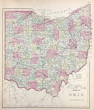
County & Township Map of the State of Ohio
Published by [W.M. Bradley & Bro.], [Philadelphia], 1886
Seller: Kaaterskill Books, ABAA/ILAB, East Jewett, NY, U.S.A.
Association Member: ABAA ILAB IOBA
Seller Rating:
Condition: Very good, faint toning. Hand colored map. 11.5 x 13.5 inches. Plate 67: County & Township Map of the State of Ohio. Copyright by S. Augustus Mitchell 1884. From: Mitchell's New General Atlas, Containing Maps Of The Various Countries Of The World, Plans Of Cities, Etc., Embraced In Ninety-Three Quarto Maps, Forming A Series Of One Hundred and Forty-seven Maps and Plans, Together With Valuable Statistical Tables. Also, A List Of Post-Offices Of The United States And Territories, And Also Census Of 1880 For States, Territories And Counties, Also Of Cities Of Over 10,000 Inhabitants. Philadelphia: Published By Wm. M. Bradley & Bro., No. 1026 Arch Street. 1886.
-
![Seller image for [Map] Indiana for sale by Kaaterskill Books, ABAA/ILAB](https://pictures.abebooks.com/inventory/md/md31156940500.jpg)
[Map] Indiana
Published by [W.M. Bradley & Bro.], [Philadelphia], 1886
Seller: Kaaterskill Books, ABAA/ILAB, East Jewett, NY, U.S.A.
Association Member: ABAA ILAB IOBA
Seller Rating:
Condition: Very good, faint toning. Hand colored map. 11 x 14 inches. Plate 68: Indiana. Copyright by S. Augustus Mitchell 1884. From: Mitchell's New General Atlas, Containing Maps Of The Various Countries Of The World, Plans Of Cities, Etc., Embraced In Ninety-Three Quarto Maps, Forming A Series Of One Hundred and Forty-seven Maps and Plans, Together With Valuable Statistical Tables. Also, A List Of Post-Offices Of The United States And Territories, And Also Census Of 1880 For States, Territories And Counties, Also Of Cities Of Over 10,000 Inhabitants. Philadelphia: Published By Wm. M. Bradley & Bro., No. 1026 Arch Street. 1886.
-
![Seller image for [Map] France [with insets] Environs of Paris [and] Switzerland in Cantons [and] Corsica for sale by Kaaterskill Books, ABAA/ILAB](https://pictures.abebooks.com/inventory/md/md31156942303.jpg)
[Map] France [with insets] Environs of Paris [and] Switzerland in Cantons [and] Corsica
Published by [W.M. Bradley & Bro.], [Philadelphia], 1886
Seller: Kaaterskill Books, ABAA/ILAB, East Jewett, NY, U.S.A.
Association Member: ABAA ILAB IOBA
Seller Rating:
Hand colored map. 15 x 11.5 inches. Plate 110. France, with insets of Environs of Paris ; Switzerland in cantons; and Corsica. Copyright by S. Augustus Mitchell 1884 From: Mitchell's New General Atlas, Containing Maps Of The Various Countries Of The World, Plans Of Cities, Etc., Embraced In Ninety-Three Quarto Maps, Forming A Series Of One Hundred and Forty-seven Maps and Plans, Together With Valuable Statistical Tables. Also, A List Of Post-Offices Of The United States And Territories, And Also Census Of 1880 For States, Territories And Counties, Also Of Cities Of Over 10,000 Inhabitants. Philadelphia: Published By Wm. M. Bradley & Bro., No. 1026 Arch Street. 1886. Very good, closely cropped margins, light soiling.
-
County Map of Nova Scotia New Brunswick Cape Breton Id. and Pr. Edward's Id. [with inset] City and Harbor of Halifax [verso with] Map of Ontario in Counties [with inset] Manitoba, Dominion of Canada
Published by [W.M. Bradley & Bro.], [Philadelphia], 1886
Seller: Kaaterskill Books, ABAA/ILAB, East Jewett, NY, U.S.A.
Association Member: ABAA ILAB IOBA
Seller Rating:
Hand colored map. Plate 7: County Map of Nova Scotia New Brunswick Cape Breton Island and Prince Edward's Island, with inset map of City and Harbor of Halifax. Copyright by S. Augustus Mitchell 1884. 10.5 x 13.5 inches. [On verso] Plate 8: Map of Ontario in Counties, with inset map of Manitoba, Dominion of Canada. Copyright by S. Augustus Mitchell 1884. 13.5 x 10.75 inches. From: Mitchell's New General Atlas, Containing Maps Of The Various Countries Of The World, Plans Of Cities, Etc., Embraced In Ninety-Three Quarto Maps, Forming A Series Of One Hundred and Forty-seven Maps and Plans, Together With Valuable Statistical Tables. Also, A List Of Post-Offices Of The United States And Territories, And Also Census Of 1880 For States, Territories And Counties, Also Of Cities Of Over 10,000 Inhabitants. Philadelphia: Published By Wm. M. Bradley & Bro., No. 1026 Arch Street. 1886. Very good, soiling and toning, tears on the outer edges, one just into image, cropped closely.
-
![Seller image for [Map] North and South Carolina [with insets] Plan of Charleston [and] Map of Charleston Harbor for sale by Kaaterskill Books, ABAA/ILAB](https://pictures.abebooks.com/inventory/md/md31156944962.jpg)
[Map] North and South Carolina [with insets] Plan of Charleston [and] Map of Charleston Harbor
Published by [W.M. Bradley & Bro.], [Philadelphia], 1886
Seller: Kaaterskill Books, ABAA/ILAB, East Jewett, NY, U.S.A.
Association Member: ABAA ILAB IOBA
Seller Rating:
Hand colored map. 14 x 11.5 inches. Plate 57: North and South Carolina, with insets Plan of Charleston; and Map of Charleston Harbor. Copyright by S. Augustus Mitchell 1884. From: Mitchell's New General Atlas, Containing Maps Of The Various Countries Of The World, Plans Of Cities, Etc., Embraced In Ninety-Three Quarto Maps, Forming A Series Of One Hundred and Forty-seven Maps and Plans, Together With Valuable Statistical Tables. Also, A List Of Post-Offices Of The United States And Territories, And Also Census Of 1880 For States, Territories And Counties, Also Of Cities Of Over 10,000 Inhabitants. Philadelphia: Published By Wm. M. Bradley & Bro., No. 1026 Arch Street. 1886. Very good, faint soiling and toning.
-
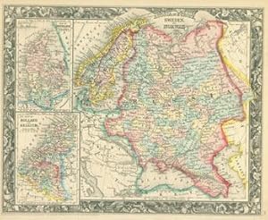
Russia In Europe, Sweden, and Norway. With Inset Maps of Denmark, Holland, and Belgium. Entered, according to Act of Congress in the year 1860 by S. Augustus Mitchell, Jr. in the Clerks Office of the District Court of the U.S. for the Eastern District of Pennsylvania.
Published by Philadelphia, PA: Augustus Mitchell., 1860
Manuscript / Paper Collectible
Condition: Good. 15.5" x 12.75" Hand-colored lithograph, Oblong, Good with tiny loss at corner, minor tears, toning, creasing.
-
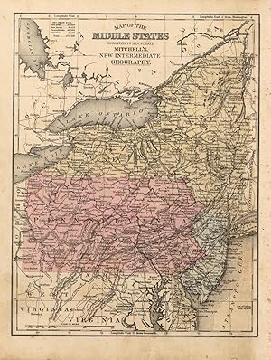
This map was created for Mitchells School Atlas published 1852 by S. Augustus Mitchell. Regions are noted by beautiful hand color. Details include the names of counties, important cities, railroads, lakes, mountains, rivers, and major roads. This map measures 16.75 inches by 10.5 inches.
-
This map was created for Mitchells School Atlas published 1852 by S. Augustus Mitchell. Regions are noted by beautiful hand color. Details include the names of counties, important cities, railroads, lakes, mountains, rivers, and major roads. This map measures 10.5 inches by 16.5 inches.
-
This map was created for Mitchells School Atlas published 1839 by S. Augustus Mitchell. Regions are noted by beautiful hand color. ' This map measures 8 inches by 10.5 inches.
-
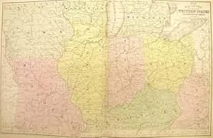
This map was produced by S.A. Mitchell in 1878 for his New Intermediate Geography. The map is nicely hand water-colored. Soon after this time period all maps were mass produced using printed color plates. This map of Asia includes a small inset map of Palestine or the Holy Land. This map measures 8.25 inches by 10.5 inches.
-
This map was produced by S.A. Mitchell in 1878 for his New Intermediate Geography. The map is nicely hand water-colored. Soon after this time period all maps were mass produced using printed color plates. This map measures 8.25 inches by 10.75 inches.
-
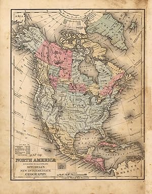
This map was made by S. Augustus Mitchell for his Atlas entitled "Mitchells New Intermediate Geography A System of Modern Geography Designed For The Use Of Schools and Academies," published in 1863. The maps from this atlas were copper-plate engraved and hand colored. This is a map of North America. This map measures 10 inches by 8 inches.
-
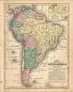
This map was created for Mitchells School Atlas published 1852 by S. Augustus Mitchell. Regions are noted by beautiful hand color. This map of South America includes and inset map of the Isthmus of Darien Showing the Route of the Railroad from Aspinwall to Panama with part of New Granada. This map measures 10.5 inches by 8 inches.

![Seller image for Map of South America, Showing Its Political Divisions [with inset] Map Showing the Proposed Atrato-Inter-Oceanic Canal Routes for Connecting the Atlantic and Pacific Oceans [verso with] Map of New Granada, Venezuela and Guiana [and] Map of Peru, and Equador [and] Map of the Argentine Confederation for sale by Kaaterskill Books, ABAA/ILAB](https://pictures.abebooks.com/inventory/md/md30506986954.jpg)
![Seller image for Map of Brazil, Bolivia, Paraguay, and Uruguay (with) Map of Chili [with inset] Harbor of Bahia [with inset] Harbor of Rio Janeiro [with inset] Island of Juan Fernandez [verso with] Map of Europe, Showing Its Gt. Political Divisions for sale by Kaaterskill Books, ABAA/ILAB](https://pictures.abebooks.com/inventory/md/md30661485704.jpg)
![Seller image for [Map] Prussia, and the German States [verso with] Map of the Austrian Empire, Italian States. Turkey in Europe, and Greece [with inset] Maltese Islands for sale by Kaaterskill Books, ABAA/ILAB](https://pictures.abebooks.com/inventory/md/md31156940495.jpg)
![Seller image for Map of Asia Showing its Gt. Political Divisions, and also the Various Routes of Travel Between London & India, China & Japan &c. [verso with] Map of Persia, Arabia, Turkey in Asia, Afghanistan, Beloochistan for sale by Kaaterskill Books, ABAA/ILAB](https://pictures.abebooks.com/inventory/md/md31156927731.jpg)
![Seller image for County Map of Nova Scotia New Brunswick Cape Breton Id. and Pr. Edward's Id. [with inset] City and Harbor of Halifax [verso with] Map of Ontario in Counties [with inset] Manitoba, Dominion of Canada for sale by Kaaterskill Books, ABAA/ILAB](https://pictures.abebooks.com/inventory/md/md31156944016.jpg)