Order Total (1 Item Items):
Shipping Destination:

The Clason Map Co (47 results)
Skip to main search results
Product Type
- All Product Types
- Books (41)
- Magazines & Periodicals
- Comics
- Sheet Music
- Art, Prints & Posters
- Photographs
- Maps (6)
-
Manuscripts &
Paper Collectibles
Condition
Binding
Collectible Attributes
Free Shipping
Seller Location
Seller Rating
-
![Seller image for Clason's Oklahoma green guide : state and city maps, auto road logs, railroads : commercial index of towns giving hotels, industries, altitudes, population, etc (1920) [LeatherBound] for sale by True World of Books](https://pictures.abebooks.com/inventory/md/md31618557707.jpg)
LeatherBound. Condition: New. LeatherBound edition. Condition: New. Reprinted from 1920 edition. Leather Binding on Spine and Corners with Golden leaf printing on spine. Bound in genuine leather with Satin ribbon page markers and Spine with raised gilt bands. A perfect gift for your loved ones. NO changes have been made to the original text. This is NOT a retyped or an ocr'd reprint. Illustrations, Index, if any, are included in black and white. Each page is checked manually before printing. As this print on demand book is reprinted from a very old book, there could be some missing or flawed pages, but we always try to make the book as complete as possible. Fold-outs, if any, are not part of the book. If the original book was published in multiple volumes then this reprint is of only one volume, not the whole set. Sewing binding for longer life, where the book block is actually sewn (smythe sewn/section sewn) with thread before binding which results in a more durable type of binding. Pages: 46.
-
![Seller image for Clason's Montana green guide : state and city maps, auto road logs, railroads : commercial index of towns giving hotels, industries, altitudes, population, etc (1921) [LeatherBound] for sale by True World of Books](https://pictures.abebooks.com/inventory/md/md31618560110.jpg)
LeatherBound. Condition: New. LeatherBound edition. Condition: New. Reprinted from 1921 edition. Leather Binding on Spine and Corners with Golden leaf printing on spine. Bound in genuine leather with Satin ribbon page markers and Spine with raised gilt bands. A perfect gift for your loved ones. NO changes have been made to the original text. This is NOT a retyped or an ocr'd reprint. Illustrations, Index, if any, are included in black and white. Each page is checked manually before printing. As this print on demand book is reprinted from a very old book, there could be some missing or flawed pages, but we always try to make the book as complete as possible. Fold-outs, if any, are not part of the book. If the original book was published in multiple volumes then this reprint is of only one volume, not the whole set. Sewing binding for longer life, where the book block is actually sewn (smythe sewn/section sewn) with thread before binding which results in a more durable type of binding. Pages: 50.
-

Soft cover. Condition: Fair. No Jacket. 47 Pages; Staple Binding; Pages Tight; Yellowed; Moderate Page Wear; No Markings On Pages. Faded Green Soft Covers With Border And Black Lettering And Illustration On Covers. Wear On Spine Ends, Edges; Some Rubbing. No Date But Cir 1920'S. Contains Information On State And City Maps; Auto Road Logs; Railroads; Commercial Index Of Towns Giving Hotels, Industries, Altitudes, Population, Etc. Many Maps And Image Of State Capitol At Madison. Sections On: Auto Road Section; Cities And Towns; Counties; Educational Institutions; Lakes; Hotels, Madison Map; Milwaukee Maps; Railroads; Rivers; State Institutions. Rear Page Provides Chard Of The Shortest Railroad Mileage Between Wisconsin Towns. Very Rare Vintage Copy.
-
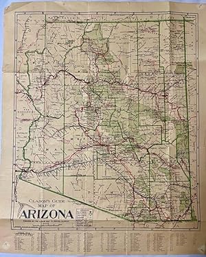
Clason's Guide Map of Arizona
Published by The Clason Map Co, Denver, 1919
Seller: Americana Books, ABAA, Stone Mt, GA, U.S.A.
Association Member: ABAA ESA ILAB IOBA
Seller Rating:

Map. Condition: Good. Map. Approx. 21" x 17". Several folds. Paper has edge wear and small edge splits at the folds. Good condition.
-
Clason?s Guide Map of MISSOURI
Published by The Clason Map Co.,, Denver, Colorado, 1885
Map First Edition
No Binding. Condition: Very Good. No Jacket. 1st Edition. 46 x 61 cm, thin paper was folded small, colored in outline , roads, railroads in red, inset of St. Louis and Vicinity, [ on right side of map] INDEX MISSOURI, Cities and Towns with Population of 700 or More Date is roughly estimated from map contents. Many original folds, a few separations on horizontal folds and some stains on back which leak through lightly.
-
No Binding. Condition: Very Good. 13 x 7" map printed in color on one side that folds to about 2 x 3" and fits into a stiff card folder printed in blue. Front panel of card folder has the following information: "Compliments of F.M. Luther & Sons Brokers, Cimarron, Kansas." Map is in near fine condition with one short separation closed with archival repair and no markings. Card stock folder slightly worn and slightly soiled. The Clason Map Company operated in Denver from the early 1900s until the Depression. It published numerous maps in different forms, including a "midget map" series. The distributor of this map, F. M. Luther & Sons, was a real estate brokerage headed by Francis [Frank] Luther, one of the founders of Cimarron, Kansas. I dated this map using a couple of named Kansas highways. The Carrie Nation Highway was established in 1917 and is shown on this map; but this map lacks a "Victory Highway" which was designated ca. 1921. A relatively rare map of Kansas.
-
Soft cover. Condition: Very Good. 1 map : col. ; 60 x 41 cm. Folded to 16 cm. X 8 cm. Relief shown by hachures and spot heights. Panel title: Map of Los Angeles. Prepared for the Lyon Fireproof Storage Co. Includes inset and index. Automobile road map of Southern California, text, and ill. on verso. A nearly fine copy of a rare map. A couple of very minor splits along the folds as well as two small holes. OCLC shows only two other known copies of this rare map.
-
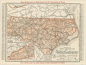
Mileage Map of the Best Roads of North Carolina Folding road map of North Carolina issued by a Lake Lanier real estate developer.
Publication Date: 1925
Seller: Curtis Wright Maps, Berwyn, IL, U.S.A.
Seller Rating:

Condition: Fine. "Bold red text across the top and bottom of this map encourages the audience to "Live all the year on Lake Lanier in the mountains at Tryon." The small mountain town is circled in an inset in the lower left, off the "highly improved" State Highway 19. The wider lines indicating paved roads (the "best" referred to in the title) are generally concentrated in urban areas and the immediate suburbs. National trails and designated routes are also marked, but the condition of these roads varied as they were often sponsored by local travel organizations or trade groups, sponsored by businesses along the way. An index of cities throughout the state, each with their respective estimated population, can be seen flanking either side of the image. The map was published by the Clason Map Company in 1925 (dated according to calendars on the inside cover) and distributed by the Tryon Development Company." Sheet Width (in) 16.25 Sheet Height (in) 12.4 Condition Description The map was originally issued folded in 18 panels and attached to green paper covers. Bright color on a full sheet, with only faint creasing along the originally issued fold lines. Excellent condition overall. Original green paper covers are present and in good shape, but separated from the map.
-
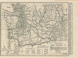
Mileage Map of the Best Roads of Washington Mid-1920s road map of Washington issued by a prominent regional auto supply company.
Publication Date: 1925
Seller: Curtis Wright Maps, Berwyn, IL, U.S.A.
Seller Rating:
Condition: Fine. "This detailed motor map of Washington State was published in 1925 by the Clason Map Company and distributed by Western Auto Supply So., according to the bold advertisements on the covers. Originally founded as a mail-order business for replacement automobile parts in Kansas City in 1909 (the year after the Model T was introduced) the first Western Auto retail store didn't open until 1921. Within a few short years, the number of establishments grew to over 100, operating primarily on the West Coast. The map highlights the paved roads, through routes, and other thoroughfares across the state. The inclusion of both pole markings (for auto trails) and numbered state highways reflect the conflicting system of roadway identification that was endemic until the widespread adoption of the U.S. Numbered Highway System (1926). An index of cities and their respective populations can be found on the left and right sides. The verso presents a simple map of the roads around the Puget Sound region, with connections shown to Mt. Rainier National Park. Source." Sheet Width (in) 17.6 Sheet Height (in) 11.6 Condition Description Double-sided pocket map folded into 16 segments and affixed to original illustrated stiff paper wraps. Light wear and creasing on the map and covers, but remains in very good condition overall.
-
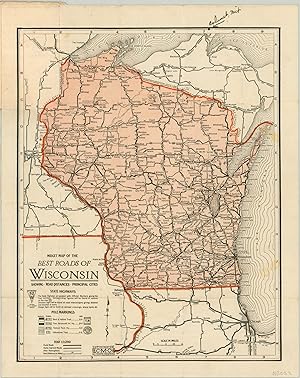
Midget Map of the Best Roads in Wisconsin The Clason Map Company's first road map of Wisconsin.
Publication Date: 1923
Seller: Curtis Wright Maps, Berwyn, IL, U.S.A.
Seller Rating:
Condition: Very Good. "This 'Midget' road map (indicating it's smaller than the regular issue) was published by the Clason Map Company in 1923. Early trail and highway markers are noted in the lower left corner, and the road legend identifies paved roads, highly improved roads, and other thoroughfares. Based on the stamp on the inside front cover (helpfully identified as a Christmas 'Brownie'), the pocket map was distributed as a holiday giveaway by the Schuster's Department store in Milwaukee. Source." Sheet Width (in) 9 Sheet Height (in) 11.3 Condition Description Moderate wear along original fold lines and three small spots visible on the right side of the sheet. Manuscript writing on the top margin identifies Calumet, Michigan. Original pictorial paper covers are attached and in good shape, but worn.
-
West Auto Supply Catalog [Maps of Western States] "More Than 100 Stores All Over the West."
Publication Date: 1925
Seller: Curtis Wright Maps, Berwyn, IL, U.S.A.
Seller Rating:
Condition: Fine. "This fascinating catalog was published in 1925 by the Western Auto Supply Company of Los Angeles. Originally founded as a mail-order business for replacement automobile parts in Kansas City in 1909 (the year after the Model T was introduced) the first Western Auto retail store didn't open until 1921. Within a few short years, the number of establishments grew to over 100, operating primarily on the West Coast. The catalog's 128 pages include a bewildering variety of vehicle components ranging from 'Kamp Kitchen Comforts' like tables and portable stoves, to tools for grinding valves and complete custom ignition systems. The firm's cord tires and new Los Angeles headquarters are prominently advertised in several areas. Six of the final seven pages contain early automobile maps showing the main and secondary roads, as well as locations of Western Auto Supply Stores, across the states of Nevada, California, Oregon, Washington, Idaho, and Utah. Source: Kansas City Public Library" Sheet Width (in) 5.75 Sheet Height (in) 8.75 Condition Description 128 pp. printed catalog with illustrated paper covers and stapled binding. Wraps are slightly chipped and creased and the contents show light toning and wear, consistent with age and use. Very good overall.
-
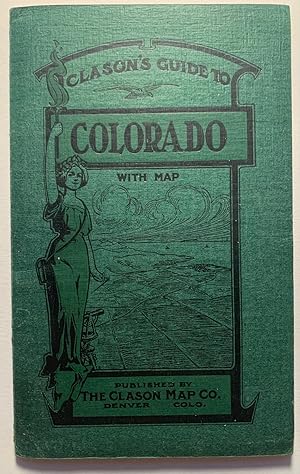
Clason's Guide to Colorado With Map--1911
Seller: Stellar Books & Ephemera, ABAA, Moab, UT, U.S.A.
Seller Rating:
Map
Clason's Guide to Colorado With Map--1911 Folding map (24 x 25 inches) tipped into staple bound booklet with green printed card stock wrappers measuring 4 x 6 3/8 inches. Booklet titled "Index To Map of Colorado" is unpaginated, but 32pp. Includes 4 full-page ads. Two small tears at folds within the map. Very Good Condition. A copy of the classic Clason Guide to Colorado from 1911. These pocket guides more often found in poor to fair condition.
-
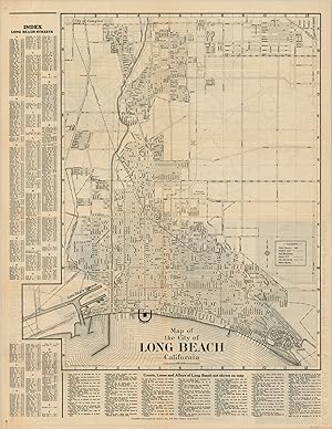
Map of the City of Long Beach California The streets of LBC decades before Snoop, Nate Dogg, and Warren G.
Publication Date: 1930
Seller: Curtis Wright Maps, Berwyn, IL, U.S.A.
Seller Rating:
Condition: Very Good. At the time this street map was published, Long Beach, California was an oil town and booming coastal city, as well as a popular seaside resort. Golf courses, parks, and other recreational facilities are shown alongside airfields, piers, transportation routes, and other elements highlighting the city's industrial prowess. A comprehensive street index can be found on the left and bottom of the sheet, while the verso includes a road map of Southern California and a photographic panorama of the Long Beach skyline. The map was created by the Clason Map Company in 1930 and printed in Long Beach by Green's Inc. Sheet Width (in) 16.75 Sheet Height (in) 21.6 Condition Description Sheet is moderately toned and worn, consistent with age. Creasing along originally issued fold lines and slight discoloration along the vertical centerfold. Front panels of the brochure (verso) are discolored, but it does not affect the image.
-
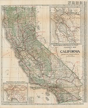
Clason's Map of California California's roads in the midst of the Roaring '20s.
Published by c. 1924, 1924
Seller: Curtis Wright Maps, Berwyn, IL, U.S.A.
Seller Rating:
Condition: Very Good. This fabulously detailed road map of California shows the burgeoning transportation network across the state in the mid-1920s. Main roads predate the numbered highway system and are individually labeled, like the Roosevelt National Trail, El Camino Real, and Pike's Peak Ocean to Ocean Highway. The various paths were undoubtedly surfaced with a variety of materials like macadam, gravel, dirt, and tar - there's even a wooden 'planked road' across the desert of Imperial County. Inset maps of the San Francisco and Los Angeles areas can be seen in the upper right and lower left, respectively. Published around 1924 in Denver by the Clason Map Company. Includes the accompanying guidebook, which presents more detailed street plans of California urban centers and an extensive index of cities and towns. Sheet Width (in) 27.5 Sheet Height (in) 33.75 Condition Description Originally issued folded into 48 panels, now separated from accompanying guidebook (64 pp., still present) and flattened. Former separation at fold intersections has been repaired on the verso, along with a few small edge tears. Minor discoloration and light offsetting visible in a few places, but overall the map and book both remain in good condition.
-
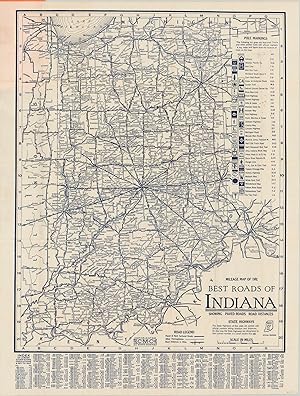
Mileage Map of the Best Roads of Indiana A thorough road map of Indiana published in the mid-1920's by the Clason Map Company.
Publication Date: 1925
Seller: Curtis Wright Maps, Berwyn, IL, U.S.A.
Seller Rating:
Condition: Fine. "This early road map of Indiana was issued just a few years after the first Federal Highway Act (1921), and shows how some of the first automobile routes developed throughout the state. State highways, partially funded by the federal government, are indicated with a small square number. National Trails and other marked routes (often sponsored by local businesses) are identified in the upper right corner and labeled individually within the image. Distances between points are also noted (in miles), and an index of towns and their population is provided at the bottom of the sheet. The map was published in 1925 by the Clason Map Company and issued by The Detroit News. Advertising the for the latter can be seen on the original covers, which assures the reader that the Detroit News has "been in the van of good road movements, safety measures, and everything that makes motoring a pleasure and safe." Sheet Width (in) 20.8 Sheet Height (in) 27.6 Condition Description Near fine condition. Originally issued folded into 35 panels with original orange paper covers. Faint creasing along fold lines, but otherwise in perfect shape.
-
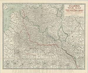
Clason's War Map of the Western Front Exhaustive survey of the Western Front in the final year of the First World War.
Published by c. 1955, 1955
Seller: Curtis Wright Maps, Berwyn, IL, U.S.A.
Seller Rating:
Condition: Fine. "This detailed map of the Western Front of WWI shows the lines of Allied advance as they tried to expel the German army from France in September of 1918. Earlier hashed lines show the tremendous gains Germany had made earlier in the war with the (almost) successful implementation of the Schlieffen Plan - a huge "right hook" that cut through Belgium southwards to Paris. The line of furthest advance highlights just how close they came to besieging the city - barely 40 miles. The bottom of the sheet presents a number of inset maps showing the primary fortresses in Belgium and France, including the myriad of satellite forts surrounding each. In these maps, it's easy to visualize how such complex networks of immense fortifications contributed to the static nature of trench warfare that came to define the First World War." Sheet Width (in) 34 Sheet Height (in) 28 Condition Description As issued originally -folded into fifty panels and affixed to two tone pictorial paper covers. Moderate creasing along the fold lines, though no discoloration or breakage. The covers are worn and a bit soiled. Near fine condition overall.
-
Clason's Nevada Green Guide The final edition of Clason's Green Guide to Nevada.
Publication Date: 1931
Seller: Curtis Wright Maps, Berwyn, IL, U.S.A.
Seller Rating:
Condition: Fine. "According to some incredible research by Carl Liedholm of Michigan State University, the Clason Map Company of Denver, Colorado first started creating pocket guides in 1906, three years after its earliest maps were issued. These were focused on the cities of Denver and Colorado Springs, but would eventually broaden to encompass entire states. In 1908, the iconic green covers were introduced, and in 1920 the name 'Green Guide' was formally adopted. Liedholm states "The Green Guides were a unique product of the Clason Map Company. They were pocket sized (approximately 4" x 6") guides that were published for many states and several cities. Each guide consisted of a booklet, ranging in length from 15 to over 60 pages with detailed information about the state or city, and one or more large maps that were pasted within the covers. Each of the state guides included a commercial index of the cities and towns that provided information on their individual populations, elevations, industries, hotels, and banks. In addition, there was general information about the state that would be of interest to the traveler on such topics as state history, scenic wonders, national parks, roads, railways, and "interesting facts about the state." Downtown city maps and pictures were incorporated into the textual descriptions." This is a fine example of the 1931 edition of Clason's Green Guide of Nevada, the last year the company published the guidebooks. A double-sided folding map of both California and Nevada shows a basic overview of both states with insets of San Diego, San Francisco, and Los Angeles. The verso focuses entirely on the road system, using a variety of lines to differentiate between surface composition and State and U.S. Highways. The guidebook includes a street plan of Reno and its downtown district and a view of the capitol building at Carson City, in addition to the aforementioned generalized contents. Source." Sheet Width (in) 20.5 Sheet Height (in) 27.75 Condition Description Folding map with light toning around the outer edges affixed to 16 pp. guidebook with illustrated stiff paper wraps. Contents show toning around the edges and light wear, but overall in very good to near fine condition.
-
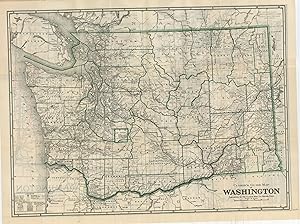
Clason's Washington Green Guide The final edition of Clason's Green Guide to Washington.
Publication Date: 1931
Seller: Curtis Wright Maps, Berwyn, IL, U.S.A.
Seller Rating:
Condition: Fine. "According to some incredible research by Carl Liedholm of Michigan State University, the Clason Map Company of Denver, Colorado first started creating pocket guides in 1906, three years after its earliest maps were issued. These were focused on the cities of Denver and Colorado Springs, but would eventually broaden to encompass entire states. In 1908, the iconic green covers were introduced, and in 1920 the name 'Green Guide' was formally adopted. Liedholm states "The Green Guides were a unique product of the Clason Map Company. They were pocket-sized (approximately 4" x 6") guides that were published for many states and several cities. Each guide consisted of a booklet, ranging in length from 15 to over 60 pages with detailed information about the state or city, and one or more large maps that were pasted within the covers. Each of the state guides included a commercial index of the cities and towns that provided information on their individual populations, elevations, industries, hotels, and banks. In addition, there was general information about the state that would be of interest to the traveler on such topics as state history, scenic wonders, national parks, roads, railways, and "interesting facts about the state." Downtown city maps and pictures were incorporated into the textual descriptions." This is a fine example of the 1931 edition of Clason's Green Guide of Washington, the last year the company published the guidebooks. A double-sided folding map shows the transportation network, system of land surveying, National Forests, and Indian Reservations across the state. The verso focuses entirely on the road system, using a variety of lines to differentiate between surface composition and State and U.S. Highways. The guidebook includes a street plan of Seattle, Spokane, and Tacoma, large-scale maps of their business sections, and a photographic view of the capitol building at Olympia; in addition to the aforementioned generalized contents. Source." Sheet Width (in) 23.6 Sheet Height (in) 16.9 Condition Description Folding map with creasing and faintly toned edges affixed to 24 pp. guidebook with illustrated stiff paper wraps. Contents are lightly discoloration around the edges and show faint wear, consistent with age and use. Very good to near fine overall.
-
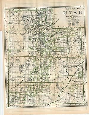
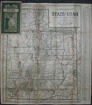
Clason's Utah Green Guide The final edition of Clason's Green Guide to Utah
Publication Date: 1931
Seller: Curtis Wright Maps, Berwyn, IL, U.S.A.
Seller Rating:
Condition: Fine. "According to some incredible research by Carl Liedholm of Michigan State University, the Clason Map Company of Denver, Colorado first started creating pocket guides in 1906, three years after its earliest maps were issued. These were focused on the cities of Denver and Colorado Springs, but would eventually broaden to encompass entire states. In 1908, the iconic green covers were introduced, and in 1920 the name 'Green Guide' was formally adopted. Liedholm states "The Green Guides were a unique product of the Clason Map Company. They were pocket-sized (approximately 4" x 6") guides that were published for many states and several cities. Each guide consisted of a booklet, ranging in length from 15 to over 60 pages with detailed information about the state or city, and one or more large maps that were pasted within the covers. Each of the state guides included a commercial index of the cities and towns that provided information on their individual populations, elevations, industries, hotels, and banks. In addition, there was general information about the state that would be of interest to the traveler on such topics as state history, scenic wonders, national parks, roads, railways, and "interesting facts about the state." Downtown city maps and pictures were incorporated into the textual descriptions." This is a fine example of the 1931 edition of Clason's Green Guide of Utah, the last year the company published the guidebooks. A double-sided folding map shows the transportation network, system of land surveying, National Forests, and Indian Reservations across the state. The verso focuses entirely on the road system, using a variety of lines to differentiate between surface composition and State and U.S. Highways. The guidebook includes a street plan of Salt Lake City and Ogden, a large-scale plan of the business section, and a photographic view of the capitol building; in addition to the aforementioned generalized contents. Source." Sheet Width (in) 17.6 Sheet Height (in) 23.6 Condition Description Folding map with light toning around the outer edges affixed to 16 pp. guidebook with illustrated stiff paper wraps. Contents show toning around the edges and light wear, but overall in very good to near fine condition.
-
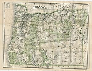
Clason's Oregon Green Guide The final edition of Clason's Green Guide to Oregon
Publication Date: 1931
Seller: Curtis Wright Maps, Berwyn, IL, U.S.A.
Seller Rating:
Condition: Fine. "According to some incredible research by Carl Liedholm of Michigan State University, the Clason Map Company of Denver, Colorado first started creating pocket guides in 1906, three years after its earliest maps were issued. These were focused on the cities of Denver and Colorado Springs, but would eventually broaden to encompass entire states. In 1908, the iconic green covers were introduced, and in 1920 the name 'Green Guide' was formally adopted. Liedholm states "The Green Guides were a unique product of the Clason Map Company. They were pocket sized (approximately 4" x 6") guides that were published for many states and several cities. Each guide consisted of a booklet, ranging in length from 15 to over 60 pages with detailed information about the state or city, and one or more large maps that were pasted within the covers. Each of the state guides included a commercial index of the cities and towns that provided information on their individual populations, elevations, industries, hotels, and banks. In addition, there was general information about the state that would be of interest to the traveler on such topics as state history, scenic wonders, national parks, roads, railways, and "interesting facts about the state." Downtown city maps and pictures were incorporated into the textual descriptions." This is a fine example of the 1931 edition of Clason's Green Guide of Oregon, the last year the company published the guidebooks. A double-sided folding map shows highlights in green the vast territories of National Forests, Parks, and Reserves, along with a basic transportation overview of the state. The verso focuses entirely on the road system, using a variety of lines to differentiate between surface composition and State and U.S. Highways. The guidebook includes a street plan for Portland and its downtown district and a view of the capitol building at Salem, in addition to the aforementioned generalized contents. Source." Sheet Width (in) 23.75 Sheet Height (in) 17.5 Condition Description Folding map with light toning around the outer edges affixed to 16 pp. guidebook with illustrated stiff paper wraps. Contents show toning around the edges and light wear, but overall in very good to near fine condition.
-
Clason's guide to California : with map of auto routes. [Series
Published by Large Folding Color Map, 1914
First Edition Signed
Saddle-stapled wraps. Condition: Near Fine. First Edition. 16mo - over 5�" - 6�" Travel Automotive Maps Clason's pocket guide maps of western states, 2] {index to Map of California].
-
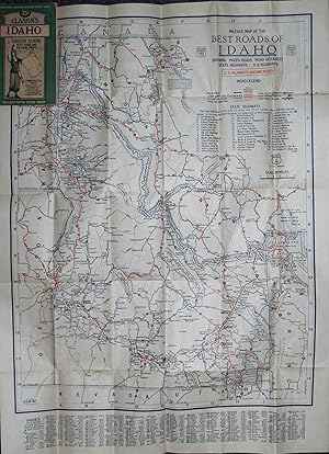
Clason's Guide Map of the State of Idaho
Published by Chicago & Denver c. 1930, Chicago & Denver, 1930
Seller: High Ridge Books, Inc. - ABAA, South Deerfield, MA, U.S.A.
Association Member: ABAA ESA ILAB SNEAB
Seller Rating:
Folding map in Clason's Idaho Green Guide. Very good condition, with light wear at edges and one short mended tear to the map. Includes 32 pp. text with place name index, lists of roads and railroads, descriptive information about the state, small uncolored map of Boise. The map is printed on both sides, with the general map on one side and a Mileage Map of the Best Roads of Idaho on the other.
-
Clason's Guide Map of Denver and Suburbs
Published by Chicago & Denver c. 1925, Chicago & Denver, 1925
Seller: High Ridge Books, Inc. - ABAA, South Deerfield, MA, U.S.A.
Association Member: ABAA ESA ILAB SNEAB
Seller Rating:
Folding map in Clason's Denver Map Guide. Stiff illustrated wrappers in very good condition, with light wear at edges. Includes 40 pp. text with street name index, extensive descriptions of notable sites, buildings and parks in the city, with a double-page plan of the tramway routes and a single-page map of the business district.
-
Clason's Guide Map of Utah
Published by Chicago & Denver c. 1919, Chicago & Denver, 1919
Seller: High Ridge Books, Inc. - ABAA, South Deerfield, MA, U.S.A.
Association Member: ABAA ESA ILAB SNEAB
Seller Rating:
Folding map in Clason's Utah Green Guide. Very good condition, with light wear at edges and one short mended tear to the map. Includes 32 pp. text with place name index, lists of roads and railroads, descriptive information about the state, small uncolored maps of Salt Lake City and the roads into and out of the city. Map is brightly colored, with roads, railroads, and national forests highlighted. Dated from population figure in text.
-
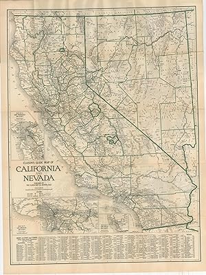
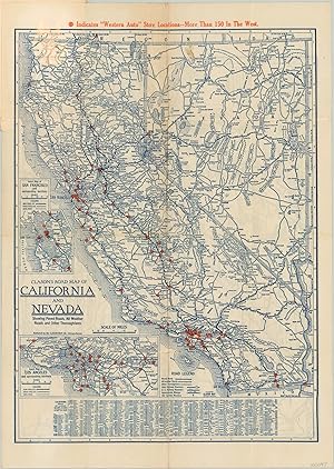
Clason's Road Map of California and Nevada Double sided pocket map showing the roads in California and Nevada.
Publication Date: 1930
Seller: Curtis Wright Maps, Berwyn, IL, U.S.A.
Seller Rating:
Condition: Very Good. This detailed transportation map was published in 1930 by the Clason Map Company and shows the most up to date road information for motorists in Nevada and California. Three separate road surfaces are identified, along with distance markers and highway numbers according to the accompanying legend in the lower center. Inset maps of San Francisco and Los Angeles are provided in the lower left. Orange dots throughout highlight the location of West Auto Supply Company store locations, while a pictorial advertisement on the front cover shows a technician with a curiously long arm. The verso of the map shows a similar mileage map of the best roads throughout Central California. Sheet Width (in) 11.9 Sheet Height (in) 17 Condition Description Issued folded into 16 panels and affixed to original paper covers, which are present and in good condition. Heavy creasing and moderate wear along fold lines, including several areas of separation. A dark spot in the upper center of the image.
-
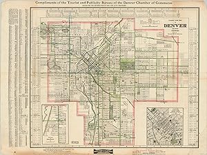
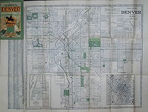
Clason's Guide Map of Denver and Suburbs Detailed city plan of Denver from the early 20th century.
Published by c. 1908, 1908
Seller: Curtis Wright Maps, Berwyn, IL, U.S.A.
Seller Rating:
Condition: Very Good. "This fascinating city plan and street index of Denver, Colorado was issued locally by the Clason Map Company around 1908, based on the buildings listed. It shows an orderly street grid with transit routes and boulevards given extra attention, as outlined in the accompanying legend at the top of the sheet. The key notes 'street car tracks not used,' alluding to the slow but inexorable shift in public transportation. The map includes two insets; the lower right shows a large scale view of the downtown area, with individual buildings labeled between Union Depot and the State Capitol. The second inset, lower left, shows the suburban municipality of Englewood immediately south of Denver. Published by the city's Chamber of Commerce, the map also encourages its audience to visit the surrounding area, through 'Denver the Gateway to 12 National Parks and 32 National Monuments." Sheet Width (in) 27.8 Sheet Height (in) 20.9 Condition Description Previously folded into 12 segments, with moderate wear and creasing along fold lines. Some areas also feature faint discoloration. There is blue crayon markings within the image, and the outer margins are worn and soiled, with several small tears repaired on verso. Remains in good, presentable condition overall.
-
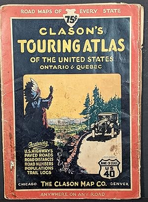
Clason's Touring Atlas of the United States Ontario & Quebec See America First! with this 1927 Clason Touring Atlas.
Publication Date: 1927
Seller: Curtis Wright Maps, Berwyn, IL, U.S.A.
Seller Rating:
Condition: Very Good. "In 1923, the Clason Map Company produced its first road atlas of the United States. An advertisement appearing in the August 4, 1923 issue of the Chicago Daily Tribune (shown at right) shows a picture of Clason's "Best Roads of the United States" atlas and proclaims that it is "just off the press; nothing like it has ever been published before." There is some validity to this claim. Although the Cram Co. had produced a "Good Roads Atlas of the United States" and an "Auto Trails and Commercial Survey of the United States" a few years earlier, the road component of theses atlases was rudimentary at best, consisting of nothing more than a few "main roads" that had been crudely overprinted in red on some already existing state railroad maps. By contrast, Clason's road atlas contained fresh state maps that focused just on the road networks and that provided such details as the mileage between towns as well as the quality of the roads. Rand McNally followed this approach as well when it launched its first U.S. road atlas one year later. Clason continued to issue updated versions of their road atlases each year until 1931." [Liedholm & Greaves] This is a copy of the Clason Map Company's 'Touring Atlas' (as opposed to the 'Motor Atlas') issued for 1927. The decorative front cover features a distinctive image of a Native American waving to a Touring Car, while the verso presents an advertisement of Powerlube Motor Oil and Bearcat Motor Fuel. Additional text on the reverse of the cover provides helpful information on 'How to Solve Car Troubles on the Road', as well as license and motor laws of various states. Subsequent contents include a highway map of America, road maps of the 48 states (plus Ontario and Quebec), as well as a distance table, and logs of major U.S. Highways. Each map highlights these primary routes in red, with main paved roads, secondary or gravel roads, and 'other thoroughfares' noted in blue. Inset maps show major urban areas while comprehensive indices list smaller towns, their respective location and population. Published by the Clason Map Company of Denver & Chicago in 1927. Dated using text from the second page - "So called U.S. Highway systems shown on 1926 maps were misleading and bothersome to the motorist for two reasons. The final routing of the U.S. Highways was not settled or their proper numbers assigned until January 2, 1927, and they were not posted during the touring season of 1926. The complete and correct official system as shown here is radically different in routing and numbering from the preliminary outline of last year." Source: Dating Clason Road Maps." Sheet Width (in) 16 Sheet Height (in) 12 Condition Description 48 pp. complete color lithographed road atlas, folded once with stapled binding and original pictorial paper cover. Moderate wear throughout, including scattered spotting, toning, creased corners, edge tears, etc. Several of the sheets show light damp staining along the bottom, confined to the margins. Fair to good overall.
-
Map of Los Angeles Dense street map of Los Angeles, California advertising for a local storage company.
Publication Date: 1926
Seller: Curtis Wright Maps, Berwyn, IL, U.S.A.
Seller Rating:
Condition: Fine. While nowhere near the sprawl that can be seen today, this 1920's street map of Los Angeles certainly gives an impression of the urban expansion that has helped to define the largest city in California. A detailed street index is provided along the top and bottom of the sheet, while the locations of Lyons Fireproof Storage Company buildings are noted with an arrow and two stars. Further advertisements can be seen on the verso, in which are offered specialized features like piano rooms, moving services, and of course, fireproof construction. An automobile road map of southern California is also provided - despite its date of 1926, the accompanying legend still identifies 'wagon roads' alongside modern means of transportation. Sheet Width (in) 21.9 Sheet Height (in) 27.9 Condition Description A bit of creasing and faint wear along originally issued fold lines, and minor soiling around the outer edges. Very good, or better, overall.
-
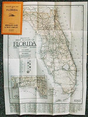
Mileage Map of the Best Roads of Florida, Showing State Highways, Road Distances, State Highways
Published by Chicago, Chicago, 1924
Seller: High Ridge Books, Inc. - ABAA, South Deerfield, MA, U.S.A.
Association Member: ABAA ESA ILAB SNEAB
Seller Rating:
Small folding map in excellent condition. Stiff orange printed wrappers, 1924-25 calendar inside front cover, ad for Merchant's Bank and Trust Co. of Daytona on the back cover. The map, lightly tinted, shows the road system of Florida, with "best roads" and "other thoroughfares" identified. Distances between towns is noted. The panhandle is shown on an inset map. The map also keys the nine different signs which designate the major roads through the state. These signs were posted periodically on poles along these routes. Index of towns, with populations, at the bottom. While Clason was a major maker of maps during this period, most of their maps dealt with areas west of the Mississippi River.
-
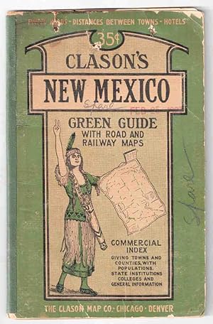
Clason's Guide Map of New Mexico
Published by Chicago & Denver c.1927, Chicago & Denver, 1927
Seller: High Ridge Books, Inc. - ABAA, South Deerfield, MA, U.S.A.
Association Member: ABAA ESA ILAB SNEAB
Seller Rating:
Folding map in Clason's New Mexico Green Guide. Good condition only, covers worn, old stains in top margin of text and along some folds of map. Three small punctures through the front cover, one through the text. Splits along maps folds mended. Includes 32 pp. text with place name index, lists of roads and railroads, descriptive information about the state, small uncolored maps of Albuquerque and Santa Fe business districts. Map is brightly colored, with roads, railroads, reservations and national forests highlighted. Dated from population figure in text. The date of the map is not stated, but it is clearly after 1921 due to the presence of Harding and Catron Counties.

![Seller image for Clason's Midget Map of Kansas [1918] for sale by Live Oak Booksellers](https://pictures.abebooks.com/inventory/md/md30455518925.jpg)
![Seller image for West Auto Supply Catalog [Maps of Western States] "More Than 100 Stores All Over the West." for sale by Curtis Wright Maps](https://pictures.abebooks.com/inventory/md/md31695378113.jpg)