Order Total (1 Item Items):
Shipping Destination:

Wit, Frederick De 1630 1706 (41 results)
Skip to main search results
Product Type
- All Product Types
- Books (15)
- Magazines & Periodicals
- Comics
- Sheet Music
- Art, Prints & Posters (17)
- Photographs
- Maps (9)
-
Manuscripts &
Paper Collectibles
Condition
- All Conditions
- New
- Used
Binding
- All Bindings
- Hardcover (3)
- Softcover
Collectible Attributes
- First Edition
- Signed (1)
- Dust Jacket
- Seller-Supplied Images (34)
- Not Printed On Demand
Free Shipping
Seller Location
Seller Rating
-
Condition: ACEPTABLE. Edici�n de Pieter van der Aa para la Galerie Agreable du Monde. Formato (cm): 25x29.
-
Condition: ACEPTABLE. Formato (cm): 20x28.
-

Condition: ACEPTABLE. Formato (cm): 20x28.
-
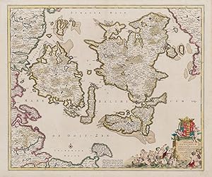
Insularum Danicarum ut Zee-Landiae, Fioniae, Langelandiae, Lalandiae, Falstriae, Fembriae, Monae, aliquarumque in Mari Balthico Sitarum descriptio
Published by Amsterdam, F. de Wit, [c.]., 1680
Art / Print / Poster
Original hand-coloured engraving. Plate Size: 58.1 cm x 48.8 cm. Sheet Size: 63.8 cm x 53 cm. Original map. In very good condition with only the slightest hints of browning to outer margns only. This beautifully engraved chart shows the main Danish islands of Funen and Zealand plus the eastern coastline of the Jutland peninsula and a little of southern Sweden. The major Danish cities like Copenhagen, Aarhus and Odense are shown on the map. The map is filled with minute detail of fortresses, cities, towns and tiny villages. Relief depicted pictorially The lower right corner of the map bears a stunningly decorative cartouche featuring the Danish royal coat-of-arms and a Classical scene of putti and merfolk frolicking in the sea with the god Mercury in the foreground. A small compass rose lies off the Schleswig Holstein coast in the Colberger Heide. Frederick de Wit (1629/1630 1706) was a Dutch cartographer and artist who drew, printed and sold maps. By 1648, during the height of the Dutch Golden Age, De Wit had moved from Gouda to Amsterdam. As early as 1654 he had opened a printing office and shop under the name "De Drie Crabben" (the Three Crabs) which was also the name of his house on the Kalverstraat. In 1655, De Wit changed the name of his shop to the "Witte Pascaert" (the White Chart). Under this name De Wit and his firm became internationally known. The first cartographic images that De Wit engraved were a plan of Haarlem that has been dated to 1648. The first charts engraved by De Wit were published in 1654 under the "De Drie Crabben" address. The first map that was both engraved and dated by De Wit was that of Denmark: "REGNI DANI� Accuratissima delineatio Perfeckte Kaerte van 't CONJNCKRYCK DENEMARCKEN" in 1659. His first world maps, "NOVA TOTIUS TERRARUM ORBIS TABULA AUCTORE F. DE WIT" and Nova Totius Terrarum Orbis Tabula appeared around 1660. His Atlas began to appear around 1662 and by 1671 included anywhere from 17 to 151 maps each. In the 1690s he began to use a new title page "Atlas Maior" but continued to use his old title page. His atlas of the Low Countries first published in 1667, was named Nieuw Kaertboeck van de XVII Nederlandse Provinci�n and contained 14 to 25 maps. De Wit quickly expanded upon his first small folio atlas which contained mostly maps printed from plates that he had acquired, to an atlas with 27 maps engraved by or for him. By 1671 he was publishing a large folio atlas with as many as 100 maps. After Frederick de Wit's death in 1706 his wife Maria continued the business for four years printing and editing De Wit's maps until 1710. However, as De Wit's son Franciscus was already a prosperous merchant by this time and had little interest in his father's business, he did not take over the publishing house. In 1710 Maria sold the firm at auction. At the auction most of the atlas plates and some of the wall map were sold to Pieter Mortier, whose publishing company grew to become one of the largest cartography publishing houses of the 18th century. The 27 chart plates from his 1675 Sea atlas were sold at the 1710 auction, to the Amsterdam print seller Luis Renard, who published them under his own name in 1715, and then sold them to Rennier and Joshua Ottens who continued to publish them until the mid-1700s. (Wikipedia).
-
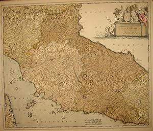
Status Ecclesiasticus et Magnus Ducatus Thoscanae
Published by Amsterdam 1680 ca., 1680
Seller: Libreria Ex Libris ALAI-ILAB/LILA member, Roma, Italy
Seller Rating:

Map
Carta geografica originale (cm. 58x49,5 pi� margini bianchi).Coloritura coeva all'acquarello. Piccole imperfezioni al margine laterale sinistro (lungo la cornice), altrimenti ottimo esemplare.
-
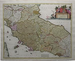
Status Ecclesiasticus et Magnus Ducatus Thoscanae.
Published by Amsterdam: Frederick De Wit, c. 1705., 1705
Single sheet, (21 x 24 � inches). Fine engraved map of central Italy, surrounded by a border of yellow wash, with EXTREMELY FINE ORIGINAL HAND COLOR IN FULL, HEIGHTENED IN LIQUID GOLD, the individual territories shown in different bold watercolors of yellow, green, and pink, the title within an ELABORATE HISTORIATED CARTOUCHE, and decorated with a fine compass rose pointing north with a GOLD-ENHANCED FLEUR-DE-LIS (old central fold, slightly toned). Beautifully engraved map of central Italy, with original hand color in full and SUMPTUOUS GOLD HIGHLIGHTS. The elegant title cartouche shows two royal figures beside two coats-of-arms with a depiction of the Emperor Constantine at center, and a merman in the blue water below bearing a banner, with two putti looking on. The lovely compass rose is colored red and green with a fleur-de-lis ENHANCED WITH LIQUID GOLD indicating north. The map's title translates to "Papal States and the Grand Duchy of Tuscany." In addition to these, the map shows the Duchy of Ferrara, the island of Elba, and part of Corsica. The Papal States were among the major historical states of Italy from roughly the 6th century until the Italian peninsula was unified in 1861. They saw their greatest extent in the 18th century, when they included most of Central Italy - Lazio, Umbria, Marche, and the Legations of Ravenna, Ferrara, and Bologna extending north into the Romagna. The Grand Duchy of Tuscany was a monarchy in central Italy that replaced the Duchy of Florence in 1569 and ruled for almost 300 years, until 1859. At the time this map was created, Cosimo III de' Medici was the Grand Duke of Tuscany, whose 53-year reign - the longest in Tuscan history - saw much upheaval and decline in the Duchy. De' Medici passed stringent morality laws taxing prostitutes and beheading sodomites, and he censored education and suppressed the Jewish minority. In response to a steep decline in population, he raised taxes exponentially to make up the difference; nevertheless, by 1705 the grand ducal treasury was nearly bankrupt, and the population had dwindled by 40%. The map is extremely detailed, showing the road that leads from Piacenza to Rimini on the Gulf of Venice. The topographical features are rendered pictorially, with the larger cities depicted as fortified citadels.
-
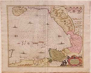
Sinus Gangeticus Vulgo Golfo de Bengala Nova Descriptio.
Published by Amsterdam: F. De Wit, [c. 1710]., 1710
Single sheet, (20 � x 24 � inches; 18 � x 21 � inches to the neat line; full margins showing the plate mark). Fine engraved map of part of the Bay of Bengal, with ORIGINAL HAND COLOR IN FULL, the individual territories shown in different bold watercolors of yellow, green, and pink, the decorative title cartouche featuring exotic figures, HEIGHTENED WITH LIQUID GOLD, the distance scale surrounded by cherubs, and 2 fine compass roses, with North oriented to the right, decorated with LIQUID GOLD (old central fold, slightly toned). Extremely fine sea chart of the Bay of Bengal, showing Ceylon (Sri Lanka), the east coast of India, Bangladesh, Burma (Myanmar), Siam (Thailand), Malaysia, and Sumatra, as well as the Andaman Islands and the Nicobar Islands. SKILLFULLY AND ATTRACTIVELY HAND-COLORED, and embellished with LIQUID GOLD. North is oriented to the right, as indicated by two very fine compass roses. With a gorgeous asymmetrical decorative cartouche and distance scale surrounded by cherubs, and the sea dotted with sailing vessels. Some of the toponymy is influenced by Ptolemy, with the Bay of Bengal being noted as "Sinus Gangeticus" and "India Intra Gangem" for the areas lying between the Indus and the Ganges. The Bay of Bengal was an extremely important trade route during the seventeenth and early eighteenth centuries, particularly for the Dutch, though local traders edged in on the European competition starting in the seventeenth century. "After 1641 the Dutch attempt to monopolize the tin trade failed in the face of strong Indian competition. In the second half of the seventeenth century the rise of Johor in alliance with the Dutch gave the Indians opportunity to establish links with Riau which was the up and coming emporium for archipelago trade. Indian Ocean traders were generally on the retreat in the face of advancing Dutch power in Indonesia but after 1670 there was some kind of a resurgence of Indian trade in the Bay of Bengal area which helped to re-establish links with western Indonesia" (Paul H. Kratoska, "South East Asia, Colonial History: Imperialism before 1800," p. 119).
-

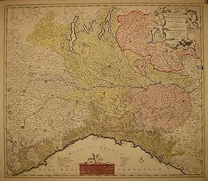
Single sheet (22 � x 19 �) Full margins showing the plate mark. (light foxing & browning along margin, light offsetting). A rare road map showing the routes for travelers and merchants from the north of Italy to Bohemia, the Netherlands, and east France, across Germany and Switzerland. The map further embraces the area of the Alps, north Italy, Tyrol, Bavaria and south Germany, and parts of Slovenia and Istria. The title cartouche features two peasants, one standing on solid ground, the other atop two parcels. This map is taken from Vissher's compiled Atlas Minor siue Geographia Compendiosa, Qua Orbis Terrarum, per paucas attamen novissimas tabulas ostenditu. This map is in excellent condition. It features full margins, original hand coloring, light browning of the edges, and slight foxing. Verso exhibits some oxidation of the ink. The route depicted here is one of the main routes used for trade in the 17th century. This Atlas acted as a guide for those involved in the various guilds, between wool, paper, ink, silver, etc. Each of the routes here held a different significance for every merchant reading the map. The key in the upper margin lists the distances. The map was published by a Dutch cartographer Frederick de Wit (1629/1630 - 1706), however it was made on commission by merchants of Bregenz, Austria. This city, known as a major trading center since the times of antiquity, is shown here in the center of the map. The unusual orientation of the map is intentional in order to fit in all the routes between the north of Italy and the Netherlands. This map is a very rare find in the market. It was frequently published individually and sometimes included in composite atlases. Such was the case with this map. It was a part of composite Visscher atlas. The Atlas Minor is a fine and comprehensive composite atlas, and one of a series of large atlases compiled and sold by the Visscher family of art dealers and cartographers in the 17th century. Founded by Nicholas Visscher, this work is known for the high quality of engraving, exceptionally fine ornament, and accurate geographical information. No two of the Visscher atlases seem to have been identical in content, and most contain, like this one, a selection of maps by the Visschers themselves as well as other cartographers. In this case the majority of the maps are published by Visscher. In addition to the striking world map by Allard with its black background and numerous projections, and found in the "Atlas Major" from about 1705, there are maps of the continents, regional maps of Europe, ten maps of Asia, and seven maps related to America. For more information on this map, or a warm welcome to see other maps and books of our collection at 72nd Street NYC, please contact Natalie Zadrozna.
-
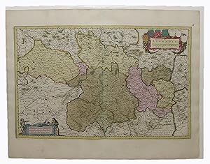
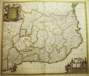
Gouvernement General du Lyonnois ou sont le Lyonnois, Auvergne, Bourbonnois, Beauiolois, Forez, et la Marche.
Published by Amsterdam: F. de Witt, c. 1705., 1705
Single sheet, (21 x 24 � inches; 15 � x 22 � inches to the neat line; full margins showing the plate mark). Fine engraved map of the Lyonnais with ORIGINAL HAND COLOR IN FULL, the individual territories shown in different bold watercolors of yellow, green, and pink, the title cartouche surrounded by the coats-of-arms of each of the regions depicted (Lyonnais, Auvergne, Bourbonnais, Beaujolais, Forez, and la Marche) and HEIGHTENED WITH LIQUID GOLD, and the distance scale embellished with three figures, two male and one female, holding what appear to be cartographic tools (slight separation at old central fold not affecting the image, slightly toned). Fine copper-engraved map with EXCEPTIONAL HAND COLOR in full, embellished with LIQUID GOLD, showing the central part of France. The title cartouche is surrounded by the coats-of-arms of each of the regions depicted (Lyonnais, Auvergne, Bourbonnais, Beaujolais, Forez, and la Marche) - although here, the last three have been left blank (seen also in other copies). Important cities are indicated with a dot of LIQUID GOLD, including: Gort, Limoges, Belac, Gueret, Nevers, Moulins, Bourbon lancy, Clermont en Auvergne, Thiers, Flour, le Puy en Velay, Villefranche, Beaujeu, and Rouanne. The Lyonnais is a historical province of France, which gets its name from the city of Lyon. "As a former province or gouvernement of the ancient regime, Lyonnais was bounded on the north by Burgundy; on the east by Dombes, Bresse, and Dauphine; on the south by Languedoc; and on the west by Auvergne and Bourbonnais. The older Lyonnais comprised the territory dependent on Lyon west of the Saone and Rhone rivers as far as the Lyonnais Mountains, east of the Rhone in the immediate vicinity of Lyon, and east of the Saone north of Lyon. It included the country around Vimy (Neufville-sur-Saone), which had the right to vote its own taxes and so was called the Franc-Lyonnais. The province was formed in the 16th century when Beaujolais and Forez were merged with the older Lyonnais" (Encyclopedia Brittanica).
-
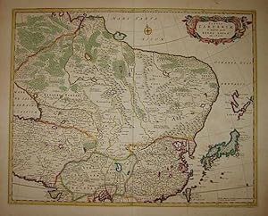
Tabula Tartariae et majoris partis Regni Chinae. Edita a F. de Wit
Published by Amsterdam 1670 ca., 1670
Seller: Libreria Ex Libris ALAI-ILAB/LILA member, Roma, Italy
Seller Rating:
Map
Incisione originale su rame (cm. 54,5x43,5 pi� ampi margini bianchi). Bella coloritura antica all'acquarello. Carta controfondata. Piccolo rinforzo al verso. Buon esemplare.
-

Insularum Sardiniae et Corsicae descriptio
Published by Amsterdam 1610 ca., 1610
Seller: Libreria Ex Libris ALAI-ILAB/LILA member, Roma, Italy
Seller Rating:
Map
Incisione originale su rame (cm. 49x58) edita da Pierre Mortier. Bella coloritura coeva all'acquarello. Margini esigui ma ottimo esemplare.
-
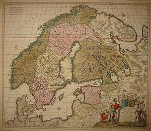
Novissima nec non perfectissima Scandinaviae Tabula comprehendens Regnorum Sueciae, Daniae et Norvegiae.
Published by Amsterdam 1690 ca., 1690
Seller: Libreria Ex Libris ALAI-ILAB/LILA member, Roma, Italy
Seller Rating:
Map
Incisione originale su rame (cm. 59x50,5 pi� margini). Splendida coloritura coeva all'acquerello. Carta controfondata e con alcuni piccoli restauri lungo la piegatura centrale. Buon esemplare.
-
Status et Ducatus Mediolanensis, Reipublicae Genuensis et Ducatus Parmensis et Montisferrati novissima descriptio
Published by Amsterdam 1680 ca., 1680
Seller: Libreria Ex Libris ALAI-ILAB/LILA member, Roma, Italy
Seller Rating:
Map
Carta geografica originale (cm. 57,5x50 pi� margini bianchi).Coloritura coeva all'acquarello. Ottimo esemplare.
-
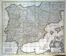
Accuratissima Totius Regni Hispaniae Portugalliae Tabula et Typus Novissimus
Published by c. 1700, Amsterdam, 1700
Art / Print / Poster
Condition: ACEPTABLE. Amstelodami ex Officina Frederici de Witt cum Privilegio D.D. Ordinum Hollandiae Westfrifix. Formato (cm): 58x50.
-
Condition: ACEPTABLE. Restaurado (2) Formato (cm): 49x38.
-
Dominii Veneti in Italia. novissima descriptio
Published by Amsterdam 1680 ca., 1680
Seller: Libreria Ex Libris ALAI-ILAB/LILA member, Roma, Italy
Seller Rating:
Map
Carta geografica originale (cm. 61,5x50 pi� margini bianchi). Bella coloritura antica all'acquarello. Ottimo esemplare.
-
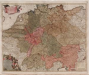
Single sheet, (21 � x 24 � inches; 19 7/8 x 23 � inches to the neat line; full margins showing the plate mark). Fine engraved map of the Holy Roman Empire (including Germany, the Kingdom of Bohemia, Belgium, and Switzerland), with ORIGINAL HAND COLOR IN FULL, the individual territories shown in different bold watercolors of yellow, green, and pink, the decorative title cartouche showing figures in Roman military garb as well as the coat-of-arms of the Holy Roman Empire, HEIGHTENED WITH LIQUID GOLD, an explanatory panel held aloft by an eagle and an angelic herald, and a fine compass rose decorated with LIQUID GOLD (old central fold, slightly toned). Extremely fine map of the Holy Roman Empire. SKILLFULLY AND ATTRACTIVELY HAND-COLORED, and embellished with LIQUID GOLD. With a gorgeous asymmetrical decorative cartouche and informative panel decorated with an angel and an eagle. The Holy Roman Empire was formed in the year 800 A.D. when Pope Leo III crowned Charlemagne as Emperor, reviving the title in Western Europe after more than 300 years. Though the term "Holy Roman Empire" was not used as such until the 13th century, the idea of the empire goes back earlier to the concept that the emperor had supreme power inherited from the emperors of Rome. This map was made after the Peace of Westphalia in 1648, which ended the Thirty Years' War. This treaty gave the individual territories of the Empire almost complete sovereignty, and both the Swiss Confederation and the Northern Netherlands left the Empire. The Habsburg Emperors then were left to focus on consolidating their own territories in Austria and elsewhere. In the 18th century the Holy Roman Empire (by this point, in effect what would become present-day Germany) entered a period of decline that would finally lead to the dissolution of the Empire during the Napoleonic Wars.
-
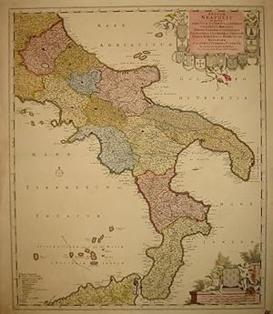
Regnum Neapolis in quo sunt Aprutium Ulterius et Citerius, Comitatus Molisius, Terra Laboris, Capitaniata, Principatus Ulterior et Citerior, Terra Bariensis et Hidruntina, Basilicata, Calabria Citerior et Ulterior
Published by Amsterdam 1680 ca., 1680
Seller: Libreria Ex Libris ALAI-ILAB/LILA member, Roma, Italy
Seller Rating:
Map
Incisione originale su rame (cm. 49x58 pi� ampi margini bianchi). Bella coloritura coeva all'acquarello. Ottimo esemplare.
-
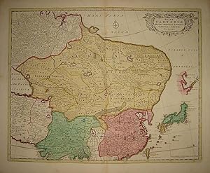
Magnae Tartariae, Magni Mogolis Imperii, Iaponiae et Chinae nova descriptio
Published by Amsterdam 1680 ca., 1680
Seller: Libreria Ex Libris ALAI-ILAB/LILA member, Roma, Italy
Seller Rating:
Map
Incisione originale su rame (cm. 54,5x43,5 pi� ampi margini bianchi). Bella coloritura antica all'acquarello. Piccolo rinforzo cartaceo al verso ma ottimo esemplare.
-
ACCURATIS SIMA TOTIUS REGNI HISPANIAE TABULA PER FREDERICUM DE WIT
Publication Date: 1660
Seller: LIBRERIA ANTICUARIA MARGARITA DE DIOS, MADRID, Spain
Association Member: LANCE
Seller Rating:
Condition: Bien. Materia: Antiguo mapa de Espa�a. Cartograf�a antigua. Publicaci�n: c.1660. Descripci�n fisica: 1 mapa, grab., 52 x 62 cm. Abarca Espa�a, Portugal y sur de Francia. Escala tambi�n expresada en: 20 Milliaria Germanica Communia 15 in uno Gradu, 30 Milliaria Gallica sive Horae Itineris 20 in uno Gradu. Orientado por rosa de cuatro vientos coronada con lis. M�rgenes graduados. Relieve representado por montes de perfil. Hidrograf�a. N�cleos de poblaci�n diferenciados seg�n su importancia. Tabla de signos convencionales para indicar obispados, arzobispados y otros centros religiosos. Toponimia local en castellano, cartela y dem�s toponimia en lat�n. Elementos decorativos: cartela con motivos arquitect�nicos, figuras humanas y �ngeles, coronada con escudo de Espa�a enmarcando t�tulo y autor. T�cnica: Grabado calcogr�fico iluminado a mano con acuarela en la �poca. Conservaci�n: Alguna marca de oxidaci�n. Frederik de Wit fue un cart�grafo y artista holand�s. La mayor�a de bibliotecas de colecciones especiales, bibliotecas de mapas raros y de colecciones privadas, guardan copias de los atlas y mapas de De Wit. Hasta la fecha, m�s de 121 y miles de mapas sueltos han sido identificados. Bibliotecas que guardan n�meros significativos son: La Biblioteca Universitaria de �msterdam, la Biblioteca Universitaria de Utrecht, la Biblioteca Universitaria de Leiden, la Biblioth�que Royale de Bruselas, la Librer�a de Mapas de Osher, . Despu�s de la muerte de De Wit en 1706, su mujer Mar�a continu� el negocio por cuatro a�os imprimiendo y editando los mapas de De Wit hasta 1710. ESS1.
-

Condition: ACEPTABLE. - F. De Wit excudit Amstelodami Theatrum Ichnographicum Omnium Urbium et Praecipuorum Oppidorum Belgicarum XVII Provinciarum Peraccurate Delineatarum Formato (cm): 51x40.
-
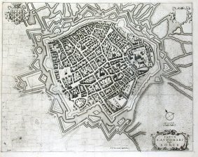
Fanum Saudomari Vulgo S. omer (Saint Omer)
Published by c. 1698, Amsterdam, 1698
Art / Print / Poster
Condition: ACEPTABLE. F. De Wit excudit Amstelodami Theatrum Ichnographicum Omnium Urbium et Praecipuorum Oppidorum Belgicarum XVII Provinciarum Peraccurate Delineatarum Plano de Somers Formato (cm): 49x39.
-
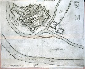
Condition: ACEPTABLE. Amstelodami apud F. De Wit Theatrum Ichnographicum Omnium Urbium et Praecipuorum Oppidorum Belgicarum XVII Provinciarum Peraccurate Delineatarum Plano de Doesburgh Formato (cm): 52x43.
-
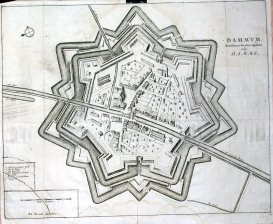
Dammum Munitissimum Flandriae oppidum vulgo Damme
Published by c. 1698, Amsterdam, 1698
Art / Print / Poster
Condition: ACEPTABLE. - F. De Wit excudit Amstelodami Theatrum Ichnographicum Omnium Urbium et Praecipuorum Oppidorum Belgicarum XVII Provinciarum Peraccurate Delineatarum Plano de Damme Formato (cm): 53x42.
-
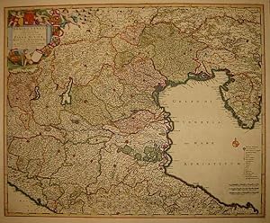
Hungariae et Regionum quae es quondam fuere unitae, ut Transilvaniae, Valachiae, Moldaviae, Serviae, Romaniae, Bulgariae, Bessarabiae, Croatiae, Bosniae, Dalmatiae, Slavoniae, Morlachiae, Ragusanae Reipublicae Maximaeq Partis Danubii Fluminis (Balcanes)
Published by Amsterdam, 1688
Art / Print / Poster
Condition: ACEPTABLE. Novissima Delineatio / Cum Privilegio / ex officina Frederici de Wit / Amstelodami 1688 (Mapa del Imperio H�ngaro) Marca de plegado, margen inferior algo deteriorado Formato (cm): 89x51.
-
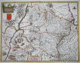
Accuratissima Principatus CATALONIAE et Comitatuum Ruscinonis et Cerretaniae Descriptio
Published by Amsterdam, 1690
Art / Print / Poster
Condition: ACEPTABLE. Grabado original coloreado a mano y delineadas a color las fronteras entre las distintas regiones catalanas. Rareza escudos en blanco. Formato (cm): 50x58.
-
Condition: ACEPTABLE. F. De Wit Excudit Amstelodami Theatrum Ichnographicum Omnium Urbium et Praecipuorum Oppidorum Belgicarum XVII Provinciarum Peraccurate Delineatarum Formato (cm): 52x41.
-
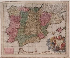
Novissima et Accuratissima Regnorum Hispaniae et Portugalliae.
Published by Amsterdam: F. De Wit, [c. 1759]., 1759
Single sheet, (21 � x 24 � inches; 19 7/8 x 23 � inches to the neat line; full margins showing the plate mark). Fine engraved map of the Iberian peninsula, showing the Kingdoms of Spain and Portugal, with ORIGINAL HAND COLOR IN FULL, the individual territories shown in different bold watercolors of yellow, green, and pink, the decorative title cartouche showing classical figures, one painting a portrait of Charles III of Spain with the caption "Caro iii D.G. Hisp. Et Ind. Rex," HEIGHTENED WITH LIQUID GOLD, and two fine compass roses decorated with LIQUID GOLD (old central fold, edges slightly frayed, lightly toned). Extremely fine map of Spain and Portugal. SKILLFULLY AND ATTRACTIVELY HAND-COLORED, and embellished with LIQUID GOLD. With a gorgeous asymmetrical historiated title cartouche. The fifth son of Philip V of Spain, but the eldest by his second wife Elizabeth Farnese, Charles III reigned over Spain and the Spanish Indies from 1759 until 1788. Prior to ascending to the throne, as Duke of Parma he conquered the kingdoms of Naples and Sicily in 1734, being crowned their king the following year. Upon succeeding to the Spanish throne in 1759, Charles abdicated the Neapolitan and Sicilian thrones in favor of Ferdinand, his third surviving son, who became Ferdinand I of the Two Sicilies. In early 1762, Spain entered the Seven Years' War, with two main objectives: to invade Portugal and capture Jamaica. Both campaigns were thwarted, and resulted in Spain's loss of Havana and Manila. The following year, in 1763, the Treaty of Paris determined that Spain would cede Florida to Great Britain in exchange for the return of Havana and Manila. These and other conflicts with Great Britain would inspire Charles to support the American revolutionaries during their War of Independence, despite any concerns he may have had that it would set a bad example for the Spanish colonies in that part of the world. Spanish military operations in West Florida and on the Mississippi River helped the 13 colonies secure their southern and western frontiers from British attack.
-
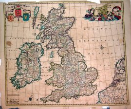
Nova Totius Angliae, Scotiae, et Hiberniae Tab.
Published by c. 1700, Amsterdam, 1700
Art / Print / Poster
Condition: ACEPTABLE. Auctore Frederick de Wit M�rgenes deteriorados. Peque�a falta de papel en margen superior Formato (cm): 57x48.
-
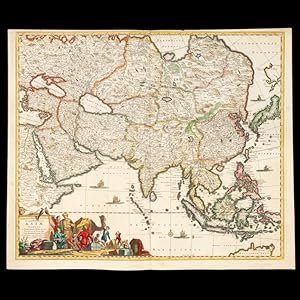
Accuratissima totius Asiae tabula : in omnes partes divisa, de nova correcta, ac in lucem edita
Seller: Douglas Stewart Fine Books, Armadale, VIC, Australia
Association Member: ANZAAB ILAB
Seller Rating:
per Fredericum de Witt Amstelodami cum privilegio D.D. ordinum Hollandiae Westristacqs ; F. de Wit excudit. [Amsterdam : Frederik de Wit, circa 1688]. Copperplate engraving on paper, 58.0 cm in diameter, on sheet 51.0 x 61.0 cm,original hand colouring, a couple of paper reinforcements verso, a very good copy. A fine large format seventeenth century map of Asia, showing the northern tip of New Holland.