Order Total (1 Item Items):
Shipping Destination:

A J Nystrom and Company (9 results)
Skip to main search results
Product Type
- All Product Types
- Books (1)
- Magazines & Periodicals
- Comics
- Sheet Music
- Art, Prints & Posters
- Photographs
- Maps (8)
-
Manuscripts &
Paper Collectibles
Condition
Binding
- All Bindings
- Hardcover (1)
- Softcover
Collectible Attributes
- First Edition
- Signed
- Dust Jacket
- Seller-Supplied Images (8)
- Not Printed On Demand (8)
Free Shipping
Seller Location
Seller Rating
-
![Seller image for Nystrom international trade desk maps. (1922) [LeatherBound] for sale by S N Books World](https://pictures.abebooks.com/inventory/md/md30962745888.jpg)
Nystrom international trade desk maps. (1922) [LeatherBound]
Publication Date: 2022
Book Print on Demand
LeatherBound. Condition: New. Leather Binding on Spine and Corners with Golden leaf printing on spine. Bound in genuine leather with Satin ribbon page markers and Spine with raised gilt bands. A perfect gift for your loved ones. Reprinted from 1922 edition. NO changes have been made to the original text. This is NOT a retyped or an ocr'd reprint. Illustrations, Index, if any, are included in black and white. Each page is checked manually before printing. As this print on demand book is reprinted from a very old book, there could be some missing or flawed pages, but we always try to make the book as complete as possible. Fold-outs, if any, are not part of the book. If the original book was published in multiple volumes then this reprint is of only one volume, not the whole set and contains approximately 40 pages. IF YOU WISH TO ORDER PARTICULAR VOLUME OR ALL THE VOLUMES YOU CAN CONTACT US. Resized as per current standards. Sewing binding for longer life, where the book block is actually sewn (smythe sewn/section sewn) with thread before binding which results in a more durable type of binding. Language: English.
-
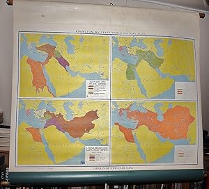
Empires of the Near East (Large Pull Down Map)
Published by A.J. Nystrom and Co., Chicago, 1970
Map
Maps. Condition: Good. 4 maps on one sheet. 97 x 128 cm. Color map mounted on muslin, wood rods top and bottom. Scale 1:10,000,000. Scale 150 miles to the inch. Contents:Egyptian and Hittite Empires, about 1450 B.C; Assyrian Empire, about 600 B.C; Lydian, Median, and Babylonian Empires, about 550 B.C; Persian Empire, about 500 B.C. Knowlton-Wallbank world history maps, K.W.2 Note: This is a large, heavy map. Additional postage will apply depending on delivery location.
-
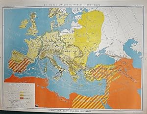
Christian Europe and the Crusades (Large pull down color map)
Published by A.J. Nystrom and Co., Chicago,, 1955
Map
Maps. Condition: Very Good. Large pull down color map of the Holy Land. Muslin fabric. Fitted with wood rods. 94 x 126 cm. 37 1/2 x 50 inches. Knowlton-Wallbank world history maps, KW9. Scale approximately 1:4,752,000. Relief shown by shading. Insets: Eastern Roman Empire, 10th and 11th centuries -- Mediterranean lands after the fourth crusade (1204). Includes note of "The map shows the extent of Christianity and the political divisions at the time of the First Crusade." The main part of the map shows Roman Catholic, Muslim, and Orthodox Christian areas; Crusade routes; Crusader victories; Muslim victories; and areas where Jews were massacred. An inset shows the Crusader states in 1140, and a timeline shows major events of the Crusades from 1092� 1291. Note: This is a large, heavy map. Additional postage will apply depending on delivery location.
-
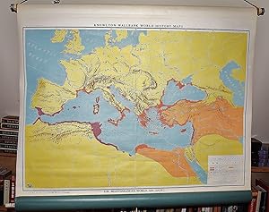
The Mediterranean World, 550-500 B.C. (Large Pull Down Map)
Published by A.J. Nystrom & Co., Chicago, 1955
Map
Maps. Condition: Very Good. 93 x 126 cm. Mounted on muslin, wood rods top and bottom. Knowlton-Wallbank world history maps, map no. K.W. 3, Map No. K.W. 3. Map showing Greek and Phoenican settlements, mother cities, and colonies as well as the Persian Empire, commercial products, and land and sea trade routes. Relief shown by shading. Scale approximately 1:4,752,000. Scale 75 miles to the inch, (W 20--E 60/N 60--20). Note: This is a large, heavy map. Additional postage will apply depending on delivery location.
-
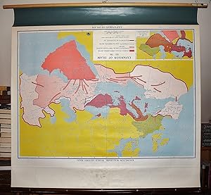
Expansion of Islam, 622-750 (Large pull down color map)
Published by A.J. Nystrom and Co., Chicago, 1955
Map
Maps. Condition: Very Good. Mounted on muslin, wood rods top and bottom. 108 x 126 cm. Scale . 1:7,096,320. Contents: Arabia in the time of Mohammed, 622-632; Conquests under the first four Caliphs, 632-661; Conquests under the Ommiads, 661-750Boundary of the Caliphate, 750. Inset: Eastern Roman Empire and western Asia on the eve of the Mohammedan conquests. Knowlton-Wallbank world history maps, K.W. 8 Note: This is a large, heavy map. Additional postage will apply depending on delivery location.
-

Christian Europe and the Crusades (Large pull down color map)
Published by A.J. Nystrom and Co., Chicago,, 1955
Map
Maps. Condition: Very Good. Large pull down color map of the Holy Land. Muslin fabric. Fitted with wood rods. 94 x 126 cm. 37 1/2 x 50 inches. Knowlton-Wallbank world history maps, KW9. Scale approximately 1:4,752,000. Relief shown by shading. Insets: Eastern Roman Empire, 10th and 11th centuries -- Mediterranean lands after the fourth crusade (1204). Includes note of "The map shows the extent of Christianity and the political divisions at the time of the First Crusade." The main part of the map shows Roman Catholic, Muslim, and Orthodox Christian areas; Crusade routes; Crusader victories; Muslim victories; and areas where Jews were massacred. An inset shows the Crusader states in 1140, and a timeline shows major events of the Crusades from 1092� 1291. Note: This is a large, heavy map. Additional postage will apply depending on delivery location.
-
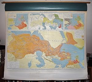
Alexander's Empire, 323 B.C. (Large Pull Down Map)
Published by A.J. Nystrom, Chicago, 1955
Map
Maps. Condition: Very Good. Mounted with spring rollers. 126 x 118 cm. Knowlton-Wallbank world history maps, map no. K.W. 4. Notes: Includes insets of Growth of Macedonia, 359-334 B.C., scale approximately 1:2,800,000, Kingdoms of Alexander's successors about 200 B.C., scale approximately 1:9,600,000, and Greek federations about 230 B.C., scale approximately 1:2,800,000. Note: This is a large, heavy map. Additional postage will apply depending on delivery location.
-
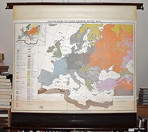
Peoples of Europe (Large Pull Down Map)
Published by A.J. Nystrom and Company, 1955
Map
Maps. Condition: Very Good. Large color map with historical linguistic and ethnic boundaries. 90 x 123 cm. "Political divisions are subsequent to World War II." Scale approximately 1:5,258,000. 83 miles to the inch. Note: This is a large, heavy map. Additional postage will apply depending on delivery location.
-
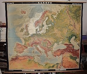
Europe : (Large Color Topographic Pull Down Map)
Published by A.J. Nystrom ; Justus Perthes, Chicago, Darmstadt, Germany, 1964
Map
Maps. Condition: Very Good. Large pull down topographic color map of modern Europe. Fitted with metal rod for wall mounting. 185 x 208 cm. 73 1/2 x 81 1/2 inches. Mounted on muslin and fitted with rods. Relief shown by shading, gradient tints, and spot heights. Depths shown by gradient tints. Shows direction of ocean currents in the Mediterranean Sea and in the Atlantic Ocean. Note: This is a large, heavy map. Additional postage will apply depending on delivery location.