
Order Total (1 Item Items):
Shipping Destination:

Becke Archibald (254 results)
Skip to main search results
Product Type
- All Product Types
- Books (40)
- Magazines & Periodicals
- Comics
- Sheet Music
- Art, Prints & Posters (1)
- Photographs
- Maps (213)
-
Manuscripts &
Paper Collectibles
Condition
Binding
Collectible Attributes
Free Shipping
Seller Location
Seller Rating
-
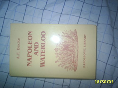
Napoleon and Waterloo: The Emperor's Campaign with the Armee Du Nord, 1815
Published by Greenhill Books, 1995
ISBN 10: 1853672068ISBN 13: 9781853672064
Book
Hardcover. Condition: Good. No Jacket. Pages can have notes/highlighting. Spine may show signs of wear. ~ ThriftBooks: Read More, Spend Less 1.3.
More buying choices from other sellers on AbeBooks
New offers from US$ 24.90
Used offers from US$ 15.51
Also find Hardcover First Edition
-

The Royal Regiment of Artillery at Le Cateau, Wednesday, 26th August, 1914 Classic Reprint
Published by Forgotten Books, 2018
ISBN 10: 133343250XISBN 13: 9781333432508
Book
PAP. Condition: New. New Book. Shipped from UK. Established seller since 2000.
More buying choices from other sellers on AbeBooks
New offers from US$ 16.88
-
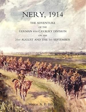
Nery,1914: the Adventure of the German 4th Cavalry Division on the 31st August And the 1st September
Published by Naval & Military Press, 2004
ISBN 10: 1845740300ISBN 13: 9781845740306
Book
Condition: As New. Unread book in perfect condition.
More buying choices from other sellers on AbeBooks
New offers from US$ 16.63
Used offers from US$ 14.42
Also find Softcover
-
![Seller image for The French Offensive in Artois 9th May - 18th June 1915 [Battle of Artois] for sale by Antiqua Print Gallery](https://pictures.abebooks.com/inventory/md/md31543328740.jpg)
The French Offensive in Artois 9th May - 18th June 1915 [Battle of Artois]
Publication Date: 1928
Map
Condition: Good. Battle of Artois 9th May - 18th June 1915. First World War. 1928 old map. Antique military history map; Map compiled by Major Archibald Frank Becke. Published by Ordnance Survey 1928 (1928). 16.0 x 12.0cm, 6.25 x 4.75 inches. Condition: Good. There is nothing printed on the reverse side, which is plain.
-
![Seller image for French Offensive in Artois. 25th Sept-15th Oct. 1915. French Offensive in Champagne. 25th Sept-16th Nov 1915 [Battle of Artois & Battle of Champagne] for sale by Antiqua Print Gallery](https://pictures.abebooks.com/inventory/md/md31543331792.jpg)
French Offensive in Artois. 25th Sept-15th Oct. 1915. French Offensive in Champagne. 25th Sept-16th Nov 1915 [Battle of Artois & Battle of Champagne]
Publication Date: 1928
Map
Condition: Good. Battle of Artois 25 Sept-15 Oct 1915 & Champagne 25 Sept-16 Nov 1915 1928 map. Antique military history map; Map compiled by Major Archibald Frank Becke. Published by Ordnance Survey 1928 (1928). 19.5 x 12.5cm, 7.75 x 5 inches. Condition: Good. There is nothing printed on the reverse side, which is plain.
-
![Seller image for General Joffre's projects for the counter-offensive [Western Front] for sale by Antiqua Print Gallery](https://pictures.abebooks.com/inventory/md/md31543335297.jpg)
Condition: Good. General Joffre's counter-offensive plans, 1914. Western Front. WW1. 1933 map. Antique military history map; Map compiled by Major Archibald Frank Becke. Published by Ordnance Survey 1936 (1933). 13.0 x 20.5cm, 5 x 8 inches. Condition: Good. There is nothing printed on the reverse side, which is plain.
-
![Seller image for Defences of Antwerp 1914 [Siege of Antwerp] for sale by Antiqua Print Gallery](https://pictures.abebooks.com/inventory/md/md31543340994.jpg)
Condition: Good. Defences of Antwerp 1914 [Siege of Antwerp]. First World War. 1925 old map. Antique military history map; Map compiled by Major Archibald Frank Becke. Published by Ordnance Survey 1924 (1925). 11.0 x 11.5cm, 4.25 x 4.5 inches. Condition: Good. There is nothing printed on the reverse side, which is plain.
-

Napoleon and Waterloo, Vol. 2
Published by Forgotten Books, 2018
ISBN 10: 1334354014ISBN 13: 9781334354014
Book
PAP. Condition: New. New Book. Shipped from UK. Established seller since 2000.
More buying choices from other sellers on AbeBooks
New offers from US$ 21.73
-
![Seller image for Action of Givenchy 15th-16th June 1915 [Battle of Artois] for sale by Antiqua Print Gallery](https://pictures.abebooks.com/inventory/md/md31543328741.jpg)
Condition: Good. Action of Givenchy 15-16th June 1915. Battle of Artois First World War. 1928 map. Antique military history map; Map compiled by Major Archibald Frank Becke. Published by Ordnance Survey 1928 (1928). 18.0 x 12.0cm, 7 x 4.75 inches. Condition: Good. There is nothing printed on the reverse side, which is plain.
-
![Seller image for The Somme, 1916. The Railways behind the British Front [Battle of the Somme] for sale by Antiqua Print Gallery](https://pictures.abebooks.com/inventory/md/md31543328751.jpg)
The Somme, 1916. The Railways behind the British Front [Battle of the Somme]
Publication Date: 1932
Map
Condition: Good. Somme, 1916. Railways behind British Front. First World War. 1932 old map. Antique military history map; Map compiled by Major Archibald Frank Becke. Published by Ordnance Survey 1930 (1932). 20.5 x 12.5cm, 8 x 5 inches. Condition: Good. There is nothing printed on the reverse side, which is plain.
-
![Seller image for Operations 4-22 August, 1914 Advance of First & Second German Armies. [Battle of the Frontiers] for sale by Antiqua Print Gallery](https://pictures.abebooks.com/inventory/md/md31543331787.jpg)
Operations 4-22 August, 1914 Advance of First & Second German Armies. [Battle of the Frontiers]
Publication Date: 1933
Map
Condition: Good. 1st & 2nd German Armies advance, 4-22 August, 1914. First World War. 1933 map. Antique military history map; Map compiled by Major Archibald Frank Becke. Published by Ordnance Survey 1920 (1933). 13.0 x 21.0cm, 5.25 x 8.25 inches. Condition: Good. There is nothing printed on the reverse side, which is plain.
-
![Seller image for Mining Areas on the British Front, 1st July 1916 [Battle of the Somme] for sale by Antiqua Print Gallery](https://pictures.abebooks.com/inventory/md/md31543331799.jpg)
Condition: Good. Mining Areas on British Front, 1st July 1916. First World War. 1932 old map. Antique military history map; Map compiled by Major Archibald Frank Becke. Published by Ordnance Survey 1930 (1932). 19.0 x 12.5cm, 7.5 x 5 inches. Condition: Good. There is nothing printed on the reverse side, which is plain.
-

Condition: Good. Western Front Theatre of Operations. German Plan 1914. First World War. 1933 map. Antique military history map; Map compiled by Major Archibald Frank Becke. Published by Ordnance Survey 1920 (1933). 13.0 x 21.5cm, 5 x 8.25 inches. Condition: Good. There is nothing printed on the reverse side, which is plain.
-
![Seller image for Verdun, 1916 [Battle of Verdun] for sale by Antiqua Print Gallery](https://pictures.abebooks.com/inventory/md/md31543339015.jpg)
Condition: Good. Battle of Verdun, 1916. First World War. 1932 old vintage map plan chart. Antique military history map; Map compiled by Major Archibald Frank Becke. Published by Ordnance Survey 1929 (1932). 12.0 x 17.0cm, 4.75 x 6.75 inches. Condition: Good. There is nothing printed on the reverse side, which is plain.
-
![Seller image for Operations, 28 August-5 September 1914. Retreat of B. E. F. [Battle the Frontiers] for sale by Antiqua Print Gallery](https://pictures.abebooks.com/inventory/md/md31543339993.jpg)
Operations, 28 August-5 September 1914. Retreat of B. E. F. [Battle the Frontiers]
Publication Date: 1933
Map
Condition: Good. Great Retreat of B.E.F., 28 August-5 September 1914. First World War. 1933 map. Antique military history map; Map compiled by Major Archibald Frank Becke. Published by Ordnance Survey 1920 (1933). 21.0 x 13.0cm, 8.25 x 5 inches. Condition: Good. There is nothing printed on the reverse side, which is plain.
-
![Seller image for The Battle-Front of the B. E. F. 26th December 1914 [Western Front] for sale by Antiqua Print Gallery](https://pictures.abebooks.com/inventory/md/md31543340995.jpg)
Condition: Good. B.E.F. Battlefront 26th December 1914. Western Front. First World War. 1927 map. Antique military history map; Map compiled by Major Archibald Frank Becke. Published by Ordnance Survey 1927 (1927). 16.0 x 12.5cm, 6.25 x 5 inches. Condition: Good. There is nothing printed on the reverse side, which is plain.
-
![Seller image for Operations 6-13 September, 1914. Advance of B. E. F. [Battle of the Marne & Battle of the Aisne] for sale by Antiqua Print Gallery](https://pictures.abebooks.com/inventory/md/md31543341990.jpg)
Operations 6-13 September, 1914. Advance of B. E. F. [Battle of the Marne & Battle of the Aisne]
Publication Date: 1933
Map
Condition: Good. Operations 6-13 September, 1914. Advance of B.E.F. WW1. 1933 old vintage map. Antique military history map; Map compiled by Major Archibald Frank Becke. Published by Ordnance Survey 1920 (1933). 20.5 x 13.0cm, 8 x 5.25 inches. Condition: Good. There is nothing printed on the reverse side, which is plain.
-
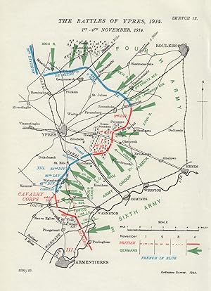
Condition: Good. Battle of Ypres, 1st-4th November 1914. First World War. 1925 old vintage map. Antique military history map; Map compiled by Major Archibald Frank Becke. Published by Ordnance Survey 1923 (1925). 17.0 x 12.5cm, 6.75 x 4.75 inches. Condition: Good. There is nothing printed on the reverse side, which is plain.
-
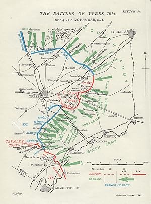
Condition: Good. Battle of Ypres, 10th & 11th November, 1914. First World War. 1925 old map. Antique military history map; Map compiled by Major Archibald Frank Becke. Published by Ordnance Survey 1923 (1925). 16.5 x 12.0cm, 6.5 x 4.75 inches. Condition: Good. There is nothing printed on the reverse side, which is plain.
-
![Seller image for The German Guard Attack 11th November 1914 [Battle of Ypres] for sale by Antiqua Print Gallery](https://pictures.abebooks.com/inventory/md/md31543335305.jpg)
Condition: Good. German Guard Attack 11th November 1914. Battle of Ypres. WW1. 1925 old map. Antique military history map; Map compiled by Major Archibald Frank Becke. Published by Ordnance Survey 1924 (1925). 11.5 x 16.0cm, 4.5 x 6.25 inches. Condition: Good. There is nothing printed on the reverse side, which is plain.
-
![Seller image for Antwerp Operations 19th Sept.-15th. Oct. 1914 [Siege of Antwerp] for sale by Antiqua Print Gallery](https://pictures.abebooks.com/inventory/md/md31543336269.jpg)
Condition: Good. Siege of Antwerp. Operations 19th Sept-15th Oct 1914. First World War. 1925 map. Antique military history map; Map compiled by Major Archibald Frank Becke. Published by Ordnance Survey 1923 (1925). 12.0 x 20.0cm, 4.75 x 7.75 inches. Condition: Good. There is nothing printed on the reverse side, which is plain.
-
![Seller image for Advance of Cavalry Corps & II & III Corps, 8th.-15th October 1914 [Western Front] for sale by Antiqua Print Gallery](https://pictures.abebooks.com/inventory/md/md31543341991.jpg)
Advance of Cavalry Corps & II & III Corps, 8th.-15th October 1914 [Western Front]
Publication Date: 1925
Map
Condition: Good. Cavalry, II & III Corps advance, 8-15th October 1914. First World War. 1925 map. Antique military history map; Map compiled by Major Archibald Frank Becke. Published by Ordnance Survey 1924 (1925). 11.5 x 18.0cm, 4.5 x 7 inches. Condition: Good. There is nothing printed on the reverse side, which is plain.
-
![Seller image for Situation 10th November, 1914 [Battle of Ypres] for sale by Antiqua Print Gallery](https://pictures.abebooks.com/inventory/md/md31543341992.jpg)
Condition: Good. Battle of Ypres, Situation 10th November, 1914. First World War. 1925 old map. Antique military history map; Map compiled by Major Archibald Frank Becke. Published by Ordnance Survey 1923 (1925). 19.0 x 12.0cm, 7.5 x 4.75 inches. Condition: Good. There is nothing printed on the reverse side, which is plain.
-
![Seller image for The Marne, situation: noon, 5th Sept 1914 [Battle of the Marne] for sale by Antiqua Print Gallery](https://pictures.abebooks.com/inventory/md/md31543328735.jpg)
Condition: Good. Battle of the Marne. Situation noon, 5th Sept 1914. WW1. 1933 old vintage map. Antique military history map; Map compiled by Major Archibald Frank Becke. Published by Ordnance Survey 1924 (1933). 10.0 x 20.0cm, 3.75 x 7.75 inches. Condition: Good. There is nothing printed on the reverse side, which is plain.
-
![Seller image for 8th September 1914. Situation as known at German G. H. Q [Battle of the Marne] for sale by Antiqua Print Gallery](https://pictures.abebooks.com/inventory/md/md31543331788.jpg)
8th September 1914. Situation as known at German G. H. Q [Battle of the Marne]
Publication Date: 1933
Map
Condition: Good. Battle of the Marne 8th September 1914. Situation as known at German HQ 1933 map. Antique military history map; Map compiled by Major Archibald Frank Becke. Published by Ordnance Survey 1931 (1933). 12.5 x 20.5cm, 5 x 8 inches. Condition: Good. There is nothing printed on the reverse side, which is plain.
-
![Seller image for Ypres, 1915. Battle of St. Julien. The British Counter-attacks on the 26th April [Battle of Ypres] for sale by Antiqua Print Gallery](https://pictures.abebooks.com/inventory/md/md31543331789.jpg)
Ypres, 1915. Battle of St. Julien. The British Counter-attacks on the 26th April [Battle of Ypres]
Publication Date: 1927
Map
Condition: Good. Battle of St Julien. British Counter-attack 26th April 1915. Ypres WW1. 1927 map. Antique military history map; Map compiled by Major Archibald Frank Becke. Published by Ordnance Survey 1926 (1927). 13.0 x 17.0cm, 5.25 x 6.75 inches. Condition: Good. There is nothing printed on the reverse side, which is plain.
-
![Seller image for Ypres, 1915. The Salient on the 30th April as it was established before the withdrawal [Battle of Ypres] for sale by Antiqua Print Gallery](https://pictures.abebooks.com/inventory/md/md31543331790.jpg)
Ypres, 1915. The Salient on the 30th April as it was established before the withdrawal [Battle of Ypres]
Publication Date: 1927
Map
Condition: Good. Ypres Salient, 30th April 1915 before withdrawal. First World War. 1927 map. Antique military history map; Map compiled by Major Archibald Frank Becke. Published by Ordnance Survey 1926 (1927). 13.0 x 17.5cm, 5 x 7 inches. Condition: Good. There is nothing printed on the reverse side, which is plain.
-
![Seller image for Ypres, 1915. Battle of Frezenberg Ridge, 13th May [Battle of Ypres] for sale by Antiqua Print Gallery](https://pictures.abebooks.com/inventory/md/md31543331791.jpg)
Condition: Good. Battle of Frezenberg Ridge, 13th May 1915. Ypres. First World War. 1927 map. Antique military history map; Map compiled by Major Archibald Frank Becke. Published by Ordnance Survey 1926 (1927). 18.0 x 12.5cm, 7 x 5 inches. Condition: Good. There is nothing printed on the reverse side, which is plain.
-
![Seller image for The Battle Front of the B. E. F. Sunday, 19th December 1915 [Battle of the Somme] for sale by Antiqua Print Gallery](https://pictures.abebooks.com/inventory/md/md31543331798.jpg)
The Battle Front of the B. E. F. Sunday, 19th December 1915 [Battle of the Somme]
Publication Date: 1932
Map
Condition: Good. B.E.F. Battlefront, 19th December 1915. Battle of the Somme. WW1. 1932 old map. Antique military history map; Map compiled by Major Archibald Frank Becke. Published by Ordnance Survey 1929 (1932). 19.5 x 12.5cm, 7.5 x 4.75 inches. Condition: Good. There is nothing printed on the reverse side, which is plain.
-
![Seller image for Hohenzollern Redoubt 2nd-18th March, 1916 [Battle of Hohenzollern Redoubt] for sale by Antiqua Print Gallery](https://pictures.abebooks.com/inventory/md/md31543331800.jpg)
Hohenzollern Redoubt 2nd-18th March, 1916 [Battle of Hohenzollern Redoubt]
Publication Date: 1932
Map
Condition: Good. Hohenzollern Redoubt 2nd-18th March, 1916. First World War. Trenches 1932 map. Antique military history map; Map compiled by Major Archibald Frank Becke. Published by Ordnance Survey 1929 (1932). 19.0 x 12.5cm, 7.5 x 5 inches. Condition: Good. There is nothing printed on the reverse side, which is plain.