Order Total (1 Item Items):
Shipping Destination:

Bouchette Joseph 1774 1841 (15 results)
Feedback
Skip to main search results
Search filters
Product Type
- All Product Types
- Books (14)
- Magazines & Periodicals (No further results match this refinement)
- Comics (No further results match this refinement)
- Sheet Music (No further results match this refinement)
- Art, Prints & Posters (No further results match this refinement)
- Photographs (No further results match this refinement)
- Maps (1)
- Manuscripts & Paper Collectibles (No further results match this refinement)
Condition
Binding
Collectible Attributes
- First Edition (4)
- Signed (No further results match this refinement)
- Dust Jacket (No further results match this refinement)
- Seller-Supplied Images (2)
- Not Print on Demand (13)
Free Shipping
Seller Rating
-
A Topographical Dictionary of the Province of Lower Canada
Published by Hardpress Publishing, 2013
ISBN 10: 1313623032 ISBN 13: 9781313623032
PAP. Condition: New. New Book. Shipped from UK. Established seller since 2000.
-

A Topographical Dictionary of the Province of Lower Canada
Published by Wentworth Press, 2016
ISBN 10: 1371667160 ISBN 13: 9781371667160
Condition: New.
-
A Topographical Dictionary of the Province of Lower Canada
Published by Hardpress Publishing, 2013
ISBN 10: 1313623032 ISBN 13: 9781313623032
Seller: PBShop.store UK, Fairford, GLOS, United Kingdom
Seller rating 5 out of 5 stars

PAP. Condition: New. New Book. Shipped from UK. Established seller since 2000.
-
The British Dominions in North America; or, A Topographical and Statistical Description of the Provinces of Lower and Upper Canada, New Brunswick, ... Breton: Including Considerations On...; 1
Published by Legare Street Press, 2021
ISBN 10: 1014194849 ISBN 13: 9781014194848
Condition: New.
-
A Topographical Dictionary of the Province of Lower Canada
Published by Hardpress Publishing, 2013
ISBN 10: 1313623032 ISBN 13: 9781313623032
Seller: THE SAINT BOOKSTORE, Southport, United Kingdom
Seller rating 5 out of 5 stars
Paperback / softback. Condition: New. New copy - Usually dispatched within 4 working days.
-
The British Dominions in North America; or; A Topographical and Statistical Description of the Provinces of Lower and Upper Canada; New Brunswick; Nova Scotia; the Islands of Newfoundland; Prince Edwa
Published by Legare Street Press, 2021
ISBN 10: 1014194849 ISBN 13: 9781014194848
Seller: Ria Christie Collections, Uxbridge, United Kingdom
Seller rating 5 out of 5 stars
Condition: New. PRINT ON DEMAND Book; New; Fast Shipping from the UK. No. book.
-
The British Dominions in North America; or, A Topographical and Statistical Description of the Provinces of Lower and Upper Canada, New Brunswick, Nova Scotia, the Islands of Newfoundland, Prince Edward and Cape Breton: Including Considerations On.; 1
Published by Legare Street Press, 2021
ISBN 10: 1014194849 ISBN 13: 9781014194848
Seller: THE SAINT BOOKSTORE, Southport, United Kingdom
Seller rating 5 out of 5 stars
Paperback / softback. Condition: New. This item is printed on demand. New copy - Usually dispatched within 5-9 working days.
-
The British Dominions in North America; or, A Topographical and Statistical Description of the Provinces of Lower and Upper Canada, New Brunswick, . Breton: Including Considerations On.; 1
Published by Legare Street Press 2021-09-09, 2021
ISBN 10: 1014194849 ISBN 13: 9781014194848
Paperback. Condition: New.
-

A Topographical Description of the Province of Lower Canada, with Remarks Upon Upper Canada, and on the Relative Connexion of Both Provinces with Th
Published by Hardpress Publishing, 2013
ISBN 10: 1314547674 ISBN 13: 9781314547672
Seller: THE SAINT BOOKSTORE, Southport, United Kingdom
Seller rating 5 out of 5 stars
Paperback / softback. Condition: New. New copy - Usually dispatched within 4 working days.
-
TOPOGRAPHICAL DICT OF THE PROV
Published by WENTWORTH PR, 2016
ISBN 10: 1371667160 ISBN 13: 9781371667160
Condition: New.
-
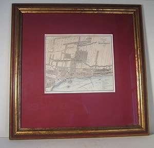
City of Montreal 1830. Map. (Ville de Montr�al 1830. Carte)
Published by Longman and others, London, 1831
Map
Condition: Very good. Size of the map : 8� x 9� in. Size of the frame : 19 x 19 in. Hand-colored, old minor restorations on margins, framed circa 1940. From the Dominions of Canada (1831). It shows the Old Montreal streets and numerous institutions. Nice piece. // Dimensions de la carte : 8� x 9� pouces. Dimensions du cadre : 19 x 19 pouces. Colori� � la main, restaurations mineures anciennes dans les marges. On y voit les rues du Vieux-Montr�al et de nombreuses institutions. Bel objet. Map.
-

A Topographical Description Of The Province Of Lower Canada, With Remarks Upon Upper Canada, And On The Relative Connexion Of Both Provinces With The United States Of America.
Published by London: Printed For The Author, And Published By W.Faden, 1815., 1815
Seller: D & E LAKE LTD. (ABAC/ILAB), Toronto, ON, Canada
Seller rating 4 out of 5 stars

First Edition
Hardcover. Condition: Very Good. 1st Edition. 8vo. pp. xv, 640, lxxxvi(appendix & index), [2]plate list & errata. engraved frontis. portrait, 8 engraved plans (4 folding), 2 engraved tables (1 folding) & 7 uncoloured aquatints. 19th century half calf (extremities worn, joints partly cracked otherwise very good). First Edition. Bouchette was Surveyor General of Lower Canada from 1804 to 1841. His work, based on years of travel and observation, is of primary historical and geographical importance. The attractive plates illustrating the volume include views of Fort Chambly, Isle aux Noix, Nicolet, St. Thomas, Harrower s Distillery, Long s Far on Lake Timiscouta, and the Great Falls on River St. John, New Brunswick, and plans of York Harbour, Oswego Harbour, the Townships on the Ottawa River, the battles of La Fourche and Chrysler s Farm, &c. Abbey, Travel, 622n. Lande 1591 (no plate count). Sabin 6849 (calling for only 6 views, but an additional folding map). TPL 1031 (imperfect). Vlach 119 (imperfect).
-
Description Topographique De La Province Du Bas Canada, Avec Des Remarques Sur Le Haut-Canada Et Sur Les Relations Des Deux Provinces Avec Les Etats Unis de l'Amerique.
Published by Printed for the author, and published by W. Faden., London, 1815
Seller: Alexandre Antique Prints, Maps & Books, Toronto, ON, Canada
Seller rating 5 out of 5 stars
First Edition
Edition : First Edition. , Half calf, with marbled boards, spine with 4 raised bands. , First Edition. Text in French., Size : 8vo., , Frontispiece portrait of Bouchette, 8 maps, and 7 aquatints in black and white: Fort Chambly, Isle aux Noix, Nicolet, St. Thomas, Harrower distillery, Long's Farm on the lake Timiscouta, the Great Falls on the Saint-Jean River., Pp: xv, 664, lxxxvi. [2]. A very good example. Text and plates are clean and crisp.
-
The British Dominions In North America; Or A Topographical And Statistical Description Of The Provinces Of Lower And Upper Canada, New Brunswick, Nova Scotia, The Islands Of Newfoundland, Prince Edward, And Cape Breton. Including Considerations On Land Gr
Published by London: Longman, Rees, Orme, Brown, Green, and Longman, 1832., 1832
Seller: D & E LAKE LTD. (ABAC/ILAB), Toronto, ON, Canada
Seller rating 4 out of 5 stars
First Edition
Hardcover. Condition: Very Good. 1st Edition. 3 Volumes in 2. 4to. pp. xxvi, [2]list of plates & errata, 498, [1 leaf]ad; xi, [1]list of plates, 296; xii, [358]. [last volume unpaginated & printed in double columns). with half-titles in Vol. II-III. engraved frontis. portrait, 11 maps & plans (9 engraved - 1 folding, 2 lithographed), & 19 plates (1 engraving, 5 aquatints, & 13 lithographs - 1 folding). 3 tables on 4 sheets (3 engraved). modern half morocco (spines sunned, some scattered foxing - quite heavy on some plates, prelims & last 2 leaves in Vol. I, several plates browned, small rubberstamp on titles). First Edition, Second Issue, with titles of Vols. I-II dated '1832' (first issue dated '1831'), intended to be sold as a three-volume set. This is a greatly expanded version of the earlier Topographical Description of Lower Canada (1813). Bouchette was Surveyor General of Lower Canada from 1804 to 1841, during which time he worked on many important projects including the determination of the boundaries between the United States and Lower Canada, and New Brunswick and Maine, and the preparation of a large scale map of Lower Canada. His work, based on years of travel and observation, is of primary historical and geographical importance. "In addition to completely reorganizing surveying and cartographic services in Lower Canada, [Bouchette] published works that demonstrate his artistic and scientific talents." (DCB) The handsome engraved, aquatint, and lithographed plates, include views of Montreal, Fredericton, Quebec City, Fort Chambly, Isle aux Noix, Long's Farm on Lake Jimiscouata, Harrower's Distillery, the great falls of the St. John, and plans of York Harbour, the Niagara River, &c. Abbey, Travel, 622. Lande 1594-95. Sabin 6848-6851 (mistakenly calls for 33 plates). TPL 1627-28 (lacking plates). cfGagnon I 527-28. cfMorgan p. 43. DCB VII pp. 95-98.
-
THE // BRITISH DOMINIONS // IN // NORTH AMERICA; // OR A // TOPOGRAPHICAL AND STATISTICAL DESCRIPTION // OF THE PROVINCES OF // LOWER AND UPPER CANADA, // NEW BRUNSWICK, NOVA SCOTIA, // THE ISLANDS OF NEWFOUNDLAND, PRINCE EDWARD, AND CAPE BRETON. // INCLUDING // CONSIDERATIONS ON LAND-GRANTING AND EMIGRATION. // TO WHICH ARE ANNEXED // STATISTICAL TABLES AND TABLES OF DISTANCES, &C. // BY JOSEPH BOUCHETTE, ESQ., // SURVEYOR GENERAL OF LOWER CANADA, LIEUT. COLONEL C.M., VIVE PRESIDENT OF THE LITERARY AND // HISTORICAL SOCIETY OF QUEBEC, AND CORRESPONDING MEMBER OF THE SOCIETY OF ARTS, LONDON. // Embellished with Views Plans of Towns Harbours &c. // IN TWO VOLUMES. // VOL. I [II.] // LONDON: // PUBLISHED BY // LONGMAN, REES, ORME, BROWN, GREEN, AND LONGMAN, // PATERNOSTER-ROW. //1832.
Published by Longman, Rees, Orme, Brown, Green, and Longman c. 1832., London:, 1832
Seller: Alexandre Antique Prints, Maps & Books, Toronto, ON, Canada
Seller rating 5 out of 5 stars
First Edition
Edition : First Edition, second issue. , Skillfully rebacked preserving contemporary blind panelled, embossed light brown full calf boards; spine raised with five (5) bands; gilt lettered title on red morocco label on two. , ?Joseph Bouchette?s books have played an important part in the geography and topography of Canada. Some them were illustrated by himself and he was also a noted cartographer.? (Spendlove pg. 86)?This work is a greatly expanded version of Bouchette?s Topographical Description, published by Faden, with some plates and maps, in 1815. Volumes I and II? were first published in 1831 by Colburn and Bently in exactly the same form, except from the different title-page imprints. Longmans reissued the book with their name on the titlepage, and they added a third volume, the Topographical Dictionary, which, as can be seen, was produced as a distinct work, with no volume indication on the title-page. (Abbey Travel)?Joseph Bouchette was a surveyor general and a militia and naval officer. From 1826 to 1829 Bouchette collected data for the book. Though he was assured of the government?s backing (the assembly had promised to buy 100 copies), as well as of support from his many friends in England, it still took him three years of effort to get three volumes published, this time only in English. The first two were entitled ?The British dominions in North America; or a topographical description of the provinces of Lower and Upper Canada?, and the third ?A topographical dictionary of the province of Lower Canada?.? (Canadian Biography)Bouchette?s regional maps and two topographical descriptions of Lower Canada are still considered an essential reference for knowledge of the territory. Bouchette became Surveyor General of Lower Canada, replacing his uncle Samuel Holland. The Township of Bouchette in Quebec was named in his honour, as well as Bouchette Street in Toronto., Size : Quarto (287x223mm)., Finely hand-coloured example. Illustrations complete with 31 plates, as listed in the lists of plates; these include: Vol I: 1. an engraved frontispiece portrait of the author in black and white, and the following hand-coloured plates entitled: 2. "Inscription on the New Monument . Source of the St. Croix"; 3. "Upper Canada // Brock's Monument // Queenston Heights" (Vignette); 4. "Sketch of By-Town, Ottawa River"; 5. "Union Bridge: By-Town. // , Ottawa River"; 6. "Plan and Elevation of the Union Bridges . Ottawa River"; 7. "Plan // of // York Harbour"; 8. "Plan // of the Town of // Goderich // Upper Canada"; 9. "Plan // of the Town of // Guelph // Upper Canada"; 10. "Sketch of // Niagara River // between Queenston ."; 11. "Lower Canada // Monument to Wolfe and Montcalm. // Quebec." (Vignette); 12. "View of the City of Montreal" (folding view); 13. "City // of // Montreal // 1830" (map); 14. "City of Quebec." (view); 15. "City of Quebec" (map); 16. "Falls of Montmorency. // Winter" (view); 17. Forges of St. Maurice (three stacked views); 18. "Village of St. Hyacinthe."; 19. "Isle aux Noix n the River Richelieu"; 20. Fort and Basin of Chambly (view); 21. "Kilborn's Mills, Stanstead. ."; 22. "Harrowers Distillery & Mill ."; 23. "Long's Farm on Lake Temiscouata.". Vol II: 24. "View of Halifax."; 25. Shubenacadie Canal - from Halifax (Plan); 26."Figurative Plan, & Views, of the Island of St. Paul."; 27."New Government House, // Frederickton, N.B."; 28. "The Great Falls on the River St. John, New Brunswick." (view); 29."Barracks, and Market House, Fredericton."; 30. "On the Kenibeckasis near St. John" (view); also in vol II uncoloured: 31. "Projected Plan of Four Townships // Emigrant Settlements // in the British Colonies of North America". Also, two plates at end of vols I and II: at p.498 of vol I and p.296 of vol II tabling Post Towns. , Volume : Two volumes in one., References : Sabin: 6848; Abbey Travel 622; Dictionary of Canadian Biography: 97-98., Portrait frontis, xxvi, list and corrections (2), 1-498, (8); xi, list of plates, (i), 1-296, (9), including two (2) engraved tables of post towns. Also with 30 engraved views, maps and plans. A fine hand-coloured example with text and plates clean and crisp.