
Order Total (1 Item Items):
Shipping Destination:

Jedidiah 1761 1826 Morse (47 results)
Feedback
Skip to main search results
Search filters
Product Type
- All Product Types
- Books (47)
- Magazines & Periodicals (No further results match this refinement)
- Comics (No further results match this refinement)
- Sheet Music (No further results match this refinement)
- Art, Prints & Posters (No further results match this refinement)
- Photographs (No further results match this refinement)
- Maps (No further results match this refinement)
- Manuscripts & Paper Collectibles (No further results match this refinement)
Condition
Binding
Collectible Attributes
- First Edition (2)
- Signed (No further results match this refinement)
- Dust Jacket (No further results match this refinement)
- Seller-Supplied Images (11)
- Not Print on Demand (21)
Free Shipping
Seller Rating
-
![Stock image for Signs of the Times [microform]: a Sermon, Preached Before the Society for Propagating the Gospel Among the Indians and Others in North America, at Their Anniversary, Nov. 1, 1810 for sale by Lucky's Textbooks](https://pictures.abebooks.com/isbn/9781015314832-us-300.jpg)
-
![Stock image for Geography Made Easy [microform]: Being an Abridgement of the American Universal Geography; to Which Are Prefixed Elements of Geography, for the Use of ... and Academies in the United States of America for sale by Lucky's Textbooks](https://pictures.abebooks.com/isbn/9781015158610-us-300.jpg)
-
![Stock image for Geography Made Easy, Being an Abridgement of the American Universal Geography [microform]: Containing Astronomical Geography, Discovery and General ... ...: to Which is Added, a Geographical... for sale by Lucky's Textbooks](https://pictures.abebooks.com/isbn/9781014984333-us-300.jpg)
-
![Seller image for The true reasons on which the election of a Hollis professor of divinity in Harvard college, was opposed at the Board of overseers, Feb. 14, 1805. By Jedidiah Morse. (1805) [LeatherBound] for sale by S N Books World](https://pictures.abebooks.com/inventory/md/md31918905762.jpg)
LeatheBound. Condition: New. Leatherbound edition. Condition: New. Leather Binding on Spine and Corners with Golden leaf printing on spine. Bound in genuine leather with Satin ribbon page markers and Spine with raised gilt bands. A perfect gift for your loved ones. Reprinted from 1805 edition. NO changes have been made to the original text. This is NOT a retyped or an ocr'd reprint. Illustrations, Index, if any, are included in black and white. Each page is checked manually before printing. As this print on demand book is reprinted from a very old book, there could be some missing or flawed pages, but we always try to make the book as complete as possible. Fold-outs, if any, are not part of the book. If the original book was published in multiple volumes then this reprint is of only one volume, not the whole set. IF YOU WISH TO ORDER PARTICULAR VOLUME OR ALL THE VOLUMES YOU CAN CONTACT US. Resized as per current standards. Sewing binding for longer life, where the book block is actually sewn (smythe sewn/section sewn) with thread before binding which results in a more durable type of binding. Pages: 40 Language: English Pages: 40.
-
The American Universal Geography: or, a View of the Present State of All the Empires, Kingdoms, States, and Republics in the Known World, and of the U (Paperback or Softback)
Published by Legare Street Press 9/10/2021, 2021
ISBN 10: 101514537X ISBN 13: 9781015145375
Language: English
Paperback or Softback. Condition: New. The American Universal Geography: or, a View of the Present State of All the Empires, Kingdoms, States, and Republics in the Known World, and of the U 1.8. Book.
-

-
![Stock image for A Report to the Secretary of War of the United States, on Indian Affairs [microform]: Comprising a Narrative of a Tour Performed in the Summer of ... for the Purpose of Ascertaining, For... for sale by Lucky's Textbooks](https://pictures.abebooks.com/isbn/9781015272217-us-300.jpg)
-
![Stock image for Geography Made Easy [microform]: Being an Abridgement of the American Universal Geography; to Which Are Prefixed Elements of Geography, for the Use of ... and Academies in the United States of America for sale by Lucky's Textbooks](https://pictures.abebooks.com/isbn/9781013866340-us-300.jpg)
-
![Stock image for Geography Made Easy, Being an Abridgement of the American Universal Geography [microform]: Containing Astronomical Geography, Discovery and General ... ...: to Which is Added, a Geographical... for sale by Lucky's Textbooks](https://pictures.abebooks.com/isbn/9781013783746-us-300.jpg)
-
![Seller image for The American universal geography, or, A view of the present state of all the empires, kingdoms, states, and republics in the known world, and of the United States of America in particular : in two parts . illustrated with maps of the countries described / by Jedidiah Morse . (1793) Volume v.2 [LeatherBound] for sale by S N Books World](https://pictures.abebooks.com/inventory/md/md31918919194.jpg)
LeatheBound. Condition: New. Leatherbound edition. Condition: New. Leather Binding on Spine and Corners with Golden leaf printing on spine. Bound in genuine leather with Satin ribbon page markers and Spine with raised gilt bands. A perfect gift for your loved ones. Reprinted from 1793 edition. NO changes have been made to the original text. This is NOT a retyped or an ocr'd reprint. Illustrations, Index, if any, are included in black and white. Each page is checked manually before printing. As this print on demand book is reprinted from a very old book, there could be some missing or flawed pages, but we always try to make the book as complete as possible. Fold-outs, if any, are not part of the book. If the original book was published in multiple volumes then this reprint is of only one volume, not the whole set. IF YOU WISH TO ORDER PARTICULAR VOLUME OR ALL THE VOLUMES YOU CAN CONTACT US. Resized as per current standards. Sewing binding for longer life, where the book block is actually sewn (smythe sewn/section sewn) with thread before binding which results in a more durable type of binding. Pages: 578 Language: English Volume v.2 Pages: 578 Volume v.2.
-
![Stock image for A Report to the Secretary of War of the United States, on Indian Affairs [microform]: Comprising a Narrative of a Tour Performed in the Summer of ... for the Purpose of Ascertaining, For... for sale by Lucky's Textbooks](https://pictures.abebooks.com/isbn/9781013918506-us-300.jpg)
-

REPORT ON THE ONEIDA STOCKBRID
Published by Creative Media Partners, LLC, 2021
ISBN 10: 1014462428 ISBN 13: 9781014462428
Language: English
Taschenbuch. Condition: Neu. Neuware.
-
The American Universal Geography: or, a View of the Present State of All the Empires, Kingdoms, States, and Republics in the Known World, and of the United States of America in Particular; Illustrated With Maps; 2
Seller: THE SAINT BOOKSTORE, Southport, United Kingdom
Seller rating 5 out of 5 stars

Hardback. Condition: New. This item is printed on demand. New copy - Usually dispatched within 5-9 working days.
-

The Traveller's Guide, Or, Pocket Gazetteer of the United States : Extracted from the Latest Edition of Morse's Universal Gazetteer / by Jedidiah Morse and Richard Morse
Published by New Haven : N. Whiting, 1832
First Edition
First Edition. Finely bound in modern aniline calf over marble boards. Raised bands with gilt-blocked title. Spine compartments uniformly tooled in gilt. A very good copy - scans and additional bibliographic detail on request. ; 323 pages; Lacks map unfortunately. Description: 323 p. ; 16 cm. Subjects: United States--Gazetteers. 1 Kg.
-
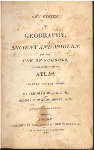
A new system of geography, ancient and modern : for the use of schools : accompanied with an atlas, adapted to the work.
Published by Boston : Published by Richardson & Lord, 75 Cornhill ; J. H. A. Frost, Printer, Congress Street, 1824, 1822., 1824
Seller: Joseph Valles - Books, Stockbridge, GA, U.S.A.
Seller rating 5 out of 5 stars
Hardcover. Condition: Poor. 23rd edition ; ix, 360 pp. ; 18 cm. ; LC: G125; Dewey: 910 ; OCLC: 16067752 ; "Dr. Morse's career as a Geographer commenced as early as the winter of 1783-84, while he was teaching a school in New Haven, and pursuing at the same time the study of Theology. The English Geography by Guthrie was the only Compend then in use in any of our schools; and that was lamentably deficient in what related to our own country. To supply this deficiency he gathered information from all the sources within his reach, and imparted it in lectures to his pupils. Aware that the same need was felt in other schools, he was led to frame the substance of his lectures into a book; and this was published in 1784,-the first Geography of any kind ever published in Am erica. It was a duodecimo of two hundred and fourteen pages, entitled 'Geography made easy.' This, taken in connection with his subsequent efforts in the same direction, fairly entitles him to the distinction of being the Father of American Geography." -- from The Life of Jedidiah Morse, D.D. By William Buell Sprague, 1874. ; 1/4 leather and marbled paper boards ; repairs to covers ; previous owner John T. Slater's writing on endpapers states "This book was bought in Ganesville [sic] February 16, 1829. Make good use of this book" ; Contents: Astronomy -- Globes -- Maps -- Earth -- America -- North America -- Greenland -- Russian Settlements -- Brttish America -- Newfoundland -- Nova Scotia -- New Brunswick -- Lower Canada -- Upper Canada -- New Britain -- United States -- Eastern States -- Maine -- New-Hampshire -- Vermont . -- Massachusetts -- Rhode Island -- Connecticut -- Middle States -- New York -- New Jersey -- Pennsylvania -- Delaware -- Maryland -- District of Columbia -- Southern States -- Virginia -- North Carolina -- South Carolina -- Georgia -- Alabama -- Mississippi -- Louisiana -- Western States -- Tennessee -- Kentucky -- Ohio -- Indiana -- Illinois -- Missouri -- Michigan Territory -- Northwest Territory -- Arkansas Territory -- Missouri Territory -- Florida -- Mexico or New Spain -- Guatimala -- West Indies -- The Bahamas -- Cuba, Hispaniola -- Jamaica, Porto Rico -- Burmudas Islands -- South America -- Republic of Columbia -- Guiana -- Peru -- Brazil -- Buenos Ayres -- Chili -- Patagonia -- Europe -- England and Wales -- Scotland -- Ireland -- Lapland -- Norway -- Sweden -- Denmark -- Russia in Europe -- Prussia -- Austria -- Germany -- Saxony -- Hanover -- Bavaria -- Wirtemberg -- Baden -- Poland -- Switzerland -- Netherlands -- France -- Spain -- Portugal -- Italy -- Ionian Republic -- Turkey in Europe -- Asia -- Turkey in Asia -- Russia in Asia -- Arabia -- Persia -- Independent Tartary -- Hindoostan -- Farther India -- China -- Chinese Tartary -- Tributary States -- Japan -- Asiatic Islands -- Isles of Sunda -- Borneo -- Philippine Islands -- Celebes -- Spice Islands -- Australasia -- Polynesia -- Africa -- Egypt -- Barbary States -- Tripoli -- Tunis -- Algiers -- Morocco -- West Africa -- South Africa -- East Africa -- Nubia -- Abyssinia -- Central Africa -- African Islands.; POOR. Book.
-
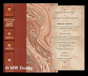
The Traveller's Guide, Or, Pocket Gazetteer of the United States : Extracted from the Latest Edition of Morse's Universal Gazetteer / by Jedidiah Morse and Richard Morse
Published by New Haven : N. Whiting, 1832
First Edition
First Edition. Finely bound in modern aniline calf over marble boards. Raised bands with gilt-blocked title. Spine compartments uniformly tooled in gilt. A very good copy - scans and additional bibliographic detail on request. ; 323 pages; Lacks map unfortunately. Description: 323 p. ; 16 cm. Subjects: United States--Gazetteers. 1 Kg.
-
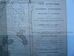
New Gazetteer of the Eastern Continent, Morse/Parish-1808
Published by Morse Jedidiah, 1761-1826, 1826
Hardcover. Condition: very good. A New Gazetteer of the Eastern Continent; or, a Geographical Dictionary: Containing, in Alphabetical Order, a Description of All the Countries, Kingdoms, States, Cities, Towns, Principal Rivers, Lakes, Harbours, Mountains, &c. &c. in Europe, Asia, Africa, with their adjacent islands. Carefully Compiled from the Best Authorities. By Jedidiah Morse,.and Elijah Parish. Pastor of the church in Byefield Newbury. Boston, July, 1808 Pages Unpaginated. 8�. Printed in two columns. Illustrated with 3 folding maps, Europe, Africa and Asia. Circa 5-600 pages, little brownish, first 2 leaves loose. From the free library of Philadelphia.
-

The American Geography; or, a view of the present situation of the United States of America.
Published by Elizabeth Town: Shepard Kollock, for the Author, 1789., 1789
Seller: Arader Galleries - AraderNYC, New York, NY, U.S.A.
Seller rating 5 out of 5 stars
Hardcover. Condition: Very Good. 8vo., (7 6/8 x 5 5/8 inches). With an errata leaf including directions to the binder and the leaf giving "Corrections Respecting France" at the end. 2 large folding engraved maps engraved by Amos Doolittle (some browning and offsetting as usual). Contemporary deerskin (rebacked to style preserving the original red morocco lettering-piece). Provenance: with the bookplate of the Free Library of Philadelphia on the front paste-down. "The time, is anticipated when all distinctions between master and slaves shall be abolished; and when the language, manners, customs, political and religious sentiments of the mixed mass of the people who inhabit the United States, shall have become so assimilated, as that all nominal distinctions shall be lost in the general and honourable name of AMERICANS" (page 68) First edition. The two maps show: ". the States of Virginia, North Carolina, South Carolina and Georgia Comprehending the Spanish Provinces of East and West Florida, Exhibiting the boundaries as fixed by the late Treaty of Peace between the United States and the Spanish dominions." (after Joseph Purcell); and ".the Northern and Middle States Comprehending the Western Territory and the British Dominions in North America." Morse was both a clergyman and one of America's most influential cartographers. His "Geography Made Easy (1784) was the first published textbook on American geography in America. Morse used a questionnaire to gain the knowledge he used to compile this second work, his "American Geography". He circulated it to "such Gentlemen as are able and likely to furnish answers", reprinted it in weekly newspapers, received numerous replies as a result. He quoted from Jefferson's "Notes on the State of Virginia" (1784) and from maps by Lewis Evans, Thomas Pownall, and others. "He queried "men of Science" for information on natural history and other specialties. He obtained statistics on population from magazines and newspapers. In his published book he did not clearly identify his many sources, and he often quoted works directly. He would not use foreign publications, with the comment that "Europeans have . . . too often suffered fancy to supply the place of facts." (Elizabeth Noble Shor for ADNB). Howes M840; Evans 21978; Sabin 50924; Wheat and Brun 149 and 491. Catalogued by Kate Hunter.
-
The American Geography; or, a view of the present situation of the United States of America.
Published by Elizabeth Town: Shepard Kollock, for the Author, 1789., 1789
Seller: Arader Galleries - AraderNYC, New York, NY, U.S.A.
Seller rating 5 out of 5 stars
Hardcover. Condition: Very Good. 8vo., (7 6/8 x 5 6/8 inches). With an errata leaf including directions to the binder at the end, and the leaf giving "Corrections Respecting France" opposite page 496. 2 large folding engraved maps engraved by Amos Doolittle (early closed tears at the gutter, folds strengthened on versos, some browning and staining). Contemporary deerskin, red morocco lettering-piece on the spine (extremities a bit scuffed, covers with a few small puncture marks, but still attractive). Provenance: with the contemporary pen-trials of Nathaniel Coles, jnr on the front free endpaper. "The time, is anticipated when all distinctions between master and slaves shall be abolished; and when the language, manners, customs, political and religious sentiments of the mixed mass of the people who inhabit the United States, shall have become so assimilated, as that all nominal distinctions shall be lost in the general and honourable name of AMERICANS" (page 68) First edition. The two maps show: ". the States of Virginia, North Carolina, South Carolina and Georgia Comprehending the Spanish Provinces of East and West Florida, Exhibiting the boundaries as fixed by the late Treaty of Peace between the United States and the Spanish dominions." (after Joseph Purcell); and ".the Northern and Middle States Comprehending the Western Territory and the British Dominions in North America." Morse was both a clergyman and one of America's most influential cartographers. His "Geography Made Easy (1784) was the first published textbook on American geography in America. Morse used a questionnaire to gain the knowledge he used to compile this second work, his "American Geography". He circulated it to "such Gentlemen as are able and likely to furnish answers", reprinted it in weekly newspapers, received numerous replies as a result. He quoted from Jefferson's "Notes on the State of Virginia" (1784) and from maps by Lewis Evans, Thomas Pownall, and others. "He queried "men of Science" for information on natural history and other specialties. He obtained statistics on population from magazines and newspapers. In his published book he did not clearly identify his many sources, and he often quoted works directly. He would not use foreign publications, with the comment that "Europeans have . . . too often suffered fancy to supply the place of facts." (Elizabeth Noble Shor for ADNB). Howes M840; Evans 21978; Sabin 50924; Wheat and Brun 149 and 491. Catalogued by Kate Hunter.
-
The American Geography; or, a view of the present situation of the United States of America
Published by Elizabeth Town: Shepard Kollock, for the Author, 1789., 1789
Seller: Arader Galleries - AraderNYC, New York, NY, U.S.A.
Seller rating 5 out of 5 stars
Hardcover. Condition: Very Good. 8vo., (7 7/8 x 5 5/8 inches). With an errata leaf including directions to the binder and the leaf giving "Corrections Respecting France" at the end. 2 EXCEPTIONALLY FINE large folding engraved maps engraved by Amos Doolittle (very small tear at mount on first map). Contemporary French mottled calf, the spine in six compartment, with five raised bands, red morocco lettering-piece in the second, the others decorated with fine gilt tools (short split in foot of upper hinge). A BEAUTIFUL COPY "The time, is anticipated when all distinctions between master and slaves shall be abolished; and when the language, manners, customs, political and religious sentiments of the mixed mass of the people who inhabit the United States, shall have become so assimilated, as that all nominal distinctions shall be lost in the general and honourable name of AMERICANS" (page 68) First edition. The two maps show: ". the States of Virginia, North Carolina, South Carolina and Georgia Comprehending the Spanish Provinces of East and West Florida, Exhibiting the boundaries as fixed by the late Treaty of Peace between the United States and the Spanish dominions." (after Joseph Purcell); and ".the Northern and Middle States Comprehending the Western Territory and the British Dominions in North America." Morse was both a clergyman and one of America's most influential cartographers. His "Geography Made Easy (1784) was the first published textbook on American geography in America. Morse used a questionnaire to gain the knowledge he used to compile this second work, his "American Geography". He circulated it to "such Gentlemen as are able and likely to furnish answers", reprinted it in weekly newspapers, received numerous replies as a result. He quoted from Jefferson's "Notes on the State of Virginia" (1784) and from maps by Lewis Evans, Thomas Pownall, and others. "He queried "men of Science" for information on natural history and other specialties. He obtained statistics on population from magazines and newspapers. In his published book he did not clearly identify his many sources, and he often quoted works directly. He would not use foreign publications, with the comment that "Europeans have . . . too often suffered fancy to supply the place of facts." (Elizabeth Noble Shor for ADNB). Howes M840; Evans 21978; Sabin 50924; Wheat and Brun 149 and 491. Catalogued by Kate Hunter.
-

The American Universal Geography, or, a View of the Present State of all the Empires, Kingdoms, States, and Republics in the Known World, and of the United States of America in Particular.
Published by Boston: Isaiah Thomas and Ebenezer T. Andrews, 1796., 1796
Seller: Arader Galleries - AraderNYC, New York, NY, U.S.A.
Seller rating 5 out of 5 stars
Hardcover. Condition: Very Good. 2 volumes. 8vo., (8 4/8 x 5 4/8 inches). 27 folding engraved maps, one full-page plate of armillary spheres (some browning and spotting and creases to the two frontispiece maps of the world and Europe). Contemporary calf, and each volume contemporarily covered with stretched deerskin wrapper (a bit rubbed). Provenance: with the ownership inscription of Thomas Sawyer on the verso of the frontispiece map of Europe in volume II. A COMPREHENSIVE WORLD GEOGRAPHY BY THE "FATHER OF AMERICAN GEOGRAPHY" Third edition of volume one which includes 2 world maps, a general map of North America and 15 regional maps, and was first published as "The American Geography; or, a view of the present situation of the United States of America" in 1789. Second edition of volume II which includes 10 maps of Europe and the rest of the world. Morse was both a clergyman and one of America's most influential cartographers. His "Geography Made Easy (1784) was the first published textbook on American geography in America. Morse used a questionnaire to gain the knowledge he used to compile this second work, his "Geography". He circulated it to "such Gentlemen as are able and likely to furnish answers", reprinted it in weekly newspapers, received numerous replies as a result. He quoted from Jefferson's "Notes on the State of Virginia" (1784) and from maps by Lewis Evans, Thomas Pownall, and others. "He queried "men of Science" for information on natural history and other specialties. He obtained statistics on population from magazines and newspapers. In his published book he did not clearly identify his many sources, and he often quoted works directly. He would not use foreign publications, with the comment that "Europeans have . . . too often suffered fancy to supply the place of facts" (Elizabeth Noble Shor for ADNB). Evans 30823; Evans 30824; Sabin 50926; Wheat and Brun, 55, 175, 188, 585, 614.
