Order Total (1 Item Items):
Shipping Destination:

John Seller Francis Lamb (1 results)
Feedback
Skip to main search results
Search filters
Product Type
- All Product Types
- Books (No further results match this refinement)
- Magazines & Periodicals (No further results match this refinement)
- Comics (No further results match this refinement)
- Sheet Music (No further results match this refinement)
- Art, Prints & Posters (No further results match this refinement)
- Photographs (No further results match this refinement)
- Maps (1)
- Manuscripts & Paper Collectibles (No further results match this refinement)
Condition
- All Conditions
- New (No further results match this refinement)
- Used (1)
Binding
- All Bindings
- Hardcover (No further results match this refinement)
- Softcover (No further results match this refinement)
Collectible Attributes
- First Edition (No further results match this refinement)
- Signed (No further results match this refinement)
- Dust Jacket (No further results match this refinement)
- Seller-Supplied Images (1)
- Not Print on Demand (1)
Free Shipping
- Free Shipping to U.S.A. (No further results match this refinement)
Seller Rating
-
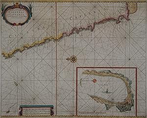
A Chart of ye coasts of Cimbebas and Caffaria from Mt. Negro to ye C. of Good Hope
Publication Date: 1701
Seller: Kunstantiquariat Andreas Senger, Hamburg, Germany
Seller rating 4 out of 5 stars

Map
Kein Einband. Condition: Gut. Es handelt sich hierbei um eine originale, altkolorierte Kupferstichlandkarte der s�dafrikanischen Atlantikk�ste von John Seller aus dem Jahr 1701. *** Titel: A Chart of ye coasts of Cimbebas and Caffaria from Mt. Negro to ye C. of Good Hope *** Gebiet bzw. Ort: S�dafrikanische K�ste zwischen dem s�dlichen Angola (Tiger Island) und dem Kap der Guten Hoffnung *** Kartograph: John Seller (1630 - 1697) / Francis Lamb - Verlegt bei Jeremiah Seller *** Jahr: 1701 *** Gr��e des Plattenbereichs: 44 x 55 cm *** Technik: Kupferstich *** Zustand (Perfekt/ Sehr gut/ Gut/ Ordentlich/ M��ig/ Schlecht): In gutem Erhaltungszustand. Insgesamt altersgem�� leicht gebr�unt. In der oberen linken Ecke leichte Flecken im Randbereich. *** Bemerkungen: �u�erst seltene, altkolorierte Seekarte der s�dafrikanischen K�ste zwischen dem s�dlichen Angola (Tiger Island) und dem Kap der Guten Hoffnung. Mit kleiner Insetkarte der Table Bay. Dekorative Gestaltung mit einer Kompassrose und einer Vielzahl von Rhumbenlinien. Die von John Seller entworfene Karte stammt aus dem von Jeremiah Seller herausgegebenen Seekartenwerk 'English Pilot', Teil V, bei Seller & Price, London 1701. In der Titelkartusche sind noch Reste der aus der Kupferplatte entfernten Angabe 'By Jer: Seller & Cha. Price Hydrographers at the Hermitage Stairs in Wapping' zu erkennen. Referenz: Shirley, R.W. (BL Atlases) M.M& P-6a, #21 *** English description: Scarce sea chart in original colours showing the coast of South Africa with an inset-map of Table Bay. By Seller & Price, London 1701. In good condition, only slightly toned by age and with a few light stains in upper margin areas. - - - International buyers welcome. If you have any questions, please don't hesitate to ask. - - - ----- Auf Wunsch stellen wir Ihnen gerne ein kostenfreies Echtheitszertifikat aus ------ If you wish, we will gladly provide a certificate of authenticity free of charge ---.