
Order Total (1 Item Items):
Shipping Destination:

Lotter C T 1717 1777 (154 results)
Feedback
Skip to main search results
Search filters
Product Type
- All Product Types
- Books (64)
- Magazines & Periodicals (No further results match this refinement)
- Comics (No further results match this refinement)
- Sheet Music (No further results match this refinement)
- Art, Prints & Posters (7)
- Photographs (No further results match this refinement)
- Maps (83)
- Manuscripts & Paper Collectibles (No further results match this refinement)
Condition
- All Conditions
- New (No further results match this refinement)
- Used (154)
Binding
- All Bindings
- Hardcover (63)
- Softcover (No further results match this refinement)
Collectible Attributes
- First Edition (1)
- Signed (1)
- Dust Jacket (No further results match this refinement)
- Seller-Supplied Images (153)
- Not Print on Demand (154)
Free Shipping
- Free Shipping to U.S.A. (No further results match this refinement)
Seller Rating
-

Hardcover. Condition: very good. Mappa Comitatuum Hannoniae, anno 1760, map, Lotter T.C. MAPPA COMITATUUM HANNONIAE, NAMURCI, et CAMERACI accurati?sime edita a Guilelmo de l'Isle, Membro Academiae Regalis Scientarum. Apud. TOBIAM. CONR. LOTTER GEOGR. AUG. VIND. Map of Belgian regions of Namur and Hainaut, published by Tobias Conrad Lotter, Augsburg, ca 1760. Size of the leaf: 55x66 cm., original publishers colours, right margin waterstained with a little loss.
-

Hardcover. Condition: very good. Champagne, anno 1760, Lotter T.C., map, old colours Le gouvernement de Champagne ; in electiones suas divisa ; cum priv. S. vic. in part. Rhe[ni] Suev. et Franc. jur ; �ri incidit et excudit Tobiam Conradum Lotter chalc. et geographum Copperengraving, edited by Lotter T.C., anno 1760, ole colours, upper margin little waterstained. Size of the map: 65x53 cm.,
-

"Artesia cum finitimis locis velut Sedes ac Theatrum Belli curiosis Spectatoribus ob oculus positum et ad normam Guisielmi de l'Isle celeberrimi Reg. Gal. Geogi. Repraesentatum. " - Arras St. Omer Pas-de-Calais Douai Lille Boulogne Abbeville Gravelines Dunkerque Karte map
Published by Augsburg, 1760
Seller: Antiquariat Steffen V�lkel GmbH, Seubersdorf, Germany
Seller rating 5 out of 5 stars

Map
Original altkolorierte Kupferstich-Karte von C. T. Lotter (1717-1777) von ca. 1760. -- Blatt-Ma�e: ca. 66 x 54 cm. -- mit alten Faltspuren, sonst gut erhalten. || Original old colored engraved map by C. T. Lotter (1717-1777) from c. 1760. -- with old fold marks, otherwise in good condition. || Dies ist ein Original! - Kein Nachdruck! - Keine Kopie! -- This is an original! No copy! - No reprint! Sprache: Franz�sisch Gewicht in Gramm: 1550.
-

Hardcover. Condition: very good. Belgien/Luxemburg, anno 1760, Lotter T.C., altkoloriert Belgien - Luxemburg. �Germaniae Inferioris sive Belgii Pars Meridionalis.� Altkol. Kupfer-Karte von T. C. Lotter um 1760. Blattma�: 53x65 cm., sehr h�bsches Verlagskolorit. Unten rechts Befestigungsgrundri� von Ostende. Zeigt Belgien, Luxemburg, Nordfrankreich, Rhein- und Saarland.
-

Comitatus Flandriae descriptio - de L'Isle, Gerard de L'Isle, Ge
Published by Lotter C.T., 1717-1777, 1777
Hardcover. Condition: very good. Comitatus Flandriae descriptio - de L'Isle, Gerard de L'Isle, Gerard Comitatus Flandriae descriptio Augsburg, Lotter, Tobias Conrad, 1760 "Comitatus Flandriae descriptio". Orig. copper-engraving, T. C. Lotter, publisher, in contemporary colours, size of the leaf: 53x65 cm., only little brownish on margins, some small tears on margins.
-

Nova Tabula Geographica ducatum Brabantiae, 1760, Lotter T.C.
Published by Lotter C.T., 1717-1777, 1777
Hardcover. Condition: very good. Nova Tabula Geographica ducatum Brabantiae, 1760, Lotter T.C., scarce map, edited by Lotter T.C., in publishers colours, upper margin little waterstained.
-

Britanniae sive Angliae Regnum, Lotter, anno 1760, Lotter, T.C.
Published by Lotter C.T., 1717-1777, 1777
Hardcover. Condition: very good. Britanniae sive Angliae Regnum, Lotter, anno 1760, Lotter, T.C. Britanniae sive Anglia Regnum, engraved map showing the Saxon kingdoms, original hand-colouring, 570 x 490mm., large decorative cartouche, Augsburg, c.1760. Contemporary publishers colours, some old restorations on upper margin, little brownish.
-

Hardcover. Condition: very good. Rhein/Main/Mosellauf, anno 1760, Lotter T. C. Synopsis Circuli Rhenani Inferioris sive Electorum Rheni. Grossformatige altkolorierte Karte zeigt das Gebiet zwischen Philippsburg, Krautheim , Kassel, Hornburg, L�ttich, Trier und Zweibr�cken. Gut erhalten. Large coloured map shows the area between Philippsburg, Krautheim , Kassel, Hornburg, L�ttich, Trier and Zweibr�cken. Blattma�: 53x65 cm., sehr sch�nes Verlagskolorit, an den R�ndern etwas fleckig; nicht in der Karte.
-

Artesia, old coloured map, Lotter T.C., anno 1740 Size of the le
Published by Lotter C.T., 1717-1777, 1777
Hardcover. Condition: very good. Artesia, old coloured map, Lotter T.C., anno 1740 Size of the leaf: 53x65 cm., very fine publishers colours, clean print. Old restored tear, not to see in front of the map.
-

Hardcover. Condition: very good. Mappa Geographica Ducatus Lotharingiae, 1760, Lotter T.C. "Mappa Geographica in qua Ducatus Lotharingiae et Barr". Blattma�: 53x65 cm., sehr sch�nes, sorgf�ltig ausgef�hrtes Verlagskolorit, lediglich geringe Randbr�unungen, nahezu perfekt erhalten. Die Karte zeigt ganz Lothringen mit Nancy im Mittelpunkt, im Nordosten noch das Saarland und Teile der Pfalz. Mit gro�er fig�rlicher Kartusche links unten.
-
Kein Einband. Condition: Gut. Liege anno 1760, Landkarte, Lotter T.C. "L' Eveche Et L'Etat De Liege / Avec les appartenances designees dans les pais voisins / Delineation nouvelle et exacte." Blattma�: 55x66 cm., originales Fl�chenkolorit, nur gering gebr�unt. Detailgenaue Karte des Gebietes um L�ttich mit dem Maasgebiet zwischen Charlemont und Roermond. Im Westen bis Br�ssel, im S�dosten bis St. Vith reichend.
-

Circulus Suevicus, anno 1760, Karte, Lotter T.C. "Circulus Suevi
Published by Lotter C.T., 1717-1777, 1777
Hardcover. Condition: very good. Circulus Suevicus, anno 1760, Karte, Lotter T.C. "Circulus Suevicus in quo Ducatus Wirtenbergensis cum reliquis Statibus et Provinciis curate designatus proponitur". Altkol. Kupf.-Kte. von M. Seutter, Augsburg, um 1740. Mit fig. Titelkart. und ornament. Kart. mit Legende und Meilanzeiger. Blattma�: 53x65 cm. Karte von W�rttemberg und den heutigen bayrischen Regierungsbezirk Schwaben (das Gebiet zwischen Bad Wimpfen u. Heilbronn i.N. und Bodensee m. Umgebung i.S. Mittig Stuttgart, Esslingen, T�bingen, Reutlingen. Sehr sch�nes, zeitgen�ssisches Altkolorit, bis auf einige, kleine Randl�suren am Fu�steg in recht ordentlichem Erhaltungszustand.
-

Hardcover. Condition: Gut. Rheinpfalz, Bergstra�e, anno 1760, Lotter T.C. "Palatinatus Inferior, sive ELECTORATUS PALATINUS AD RHENUM."Karte der Pfalz mit dem Rheinlauf von Rastatt bis St. Goar, Verlagskolorit. Blattma�: 53x65 cm., div. Randl�suren, etwas gebr�unt.
-

Hardcover. Condition: very good. Italien, Gesamtansicht, Karte, anno 1760, Lotter T.C. Italia annexis Insulis Sicilia, Sardinia et Corsica secundum observationes Societatis Regiae Scientiarum quae est Parisiis et diversorum celeberrimorum Astronorum noviter et accuratiss. exarata Cura et sumptibus Tob. Conr. Lotter, Calcogr. Aug. Vind. 1758 Augsburg/um 1760, Blattma�: 53x65 cm., sehr sch�nes Altkolorit, etwas fleckig, kleiner alt hinterlegter, von vorne nicht zu sehender Riss, leider mit einem gr��eren Fleck auf ca 20x1 cm.
-

Hardcover. Condition: very good. Tabula Hungaria, anno 1760, Lotter T.C. "Tabula Hungaria et Regionum, quae praeterae ab ea dependent. Delineata juxta magnum numerum anotationum at mappas manusscriptas vel impressas. Correcta per Observatioones Comitis Marsilii et non nullorum aliorum Per G. de L' Isle, Geographum Academiae Reg: Scientiarum apud Tob: Conr: Lotter Aug. Vind." Blattma�: 55x66 cm., altkoloriert, am rechten Plattenrand etwas ausgefranzt-bis zur Einfassungslinie.
-
Kein Einband. Condition: Gut. Comitatus NAMURCENSIS, anno 1760, Lotter T.C., map. Size of the leaf: 53x65 cm., in contemporary publishers colours, good print, only little brownish. Namur county bordered by Hainaut, Brabant and Luxembourg. In the center of the map of Namur and the Meuse can clearly be seen. Tobias Lotter drew this map based on his own observations. The title cartouche shows Lotter in his survey work and images of abundance symbolising fertility.
-
Hardcover. Condition: very good. Dauphine/Sabaudiae-anno 1760, map Lotter Dauphine sive Delphinatus superior et inferior nec non Ducatus Sabaudiae pars maxima: Lotter, Tobias Conrad Size of the leaf: 53x65 cm., original publishers colours, some restored tears but only on margins, not in the map.
-

Regnum Hiberniae, anno 1760, map, Lotter T.C. "Regnum Hiberniae
Published by Lotter C.T., 1717-1777, 1777
Hardcover. Condition: very good. "Regnum Hiberniae, anno 1760, map, Lotter T.C. "Regnum Hiberniae, tam Secundum IV Provincias Principales Ultoniam, Connaciam, Lageniam, Momoniam" The title cartouche supports the royal British arms and the large pictorial cartouche at bottom presents a bucolic scene of Mercury with herdsmen, shepherds and fishermen and supports the Irish coat of arms. Printed in original publishers colours, upper margin little brownish, size of the leaf: 65x53 cm.".
-
Hardcover. Condition: very good. Postroutenkarte v.Th�ringen,Sachsen, anno 1758, Lotter "Saxoniae Superioris. Praesertim Electoralis Circulus, cum adjacentibus Ducatibus et Provinciss, simulque diligentisime annotatis Postarum Cursus et Stationes Mappa Geographica recens et accurate delineata per Tob. Conradum Lotter Calcographum Aug. Vindel 1758." Seltene Postroutenkarte von Th�ringen, Sachsen und Sachsen Anhalt. Die Karte wird begrenzt im S�den durch Coburg, Eger, Prag, im Osten durch L�bau, im Norden durch Magdeburg und im Westen durch Eisenach, Schmalkalden. Blattma�: 55x66 cm., sehr sch�nes zeitgen�ssisches Fl�chenkolorit, nur gering gebr�unt.
-

Hispania ex Archetypo, anno 1760, Lotter T.C., altkoloriert
Published by Lotter C.T., 1717-1777, 1777
Hardcover. Condition: very good. Hispania ex Archetypo, anno 1760, Lotter T.C., altkoloriert Hispania ex Archetypo Roderici Mendez Sylvae et variis Relationibus et Chartis manu scriptis et impressis hujus Regni rectificatis. - Spanien, Portugal, Balearen - Blattma�: 53x65 cm., sehr sch�nes altes Fl�chenkolorit, an den Plattenr�ndern etwas gebr�unt, min. Randl�suren, nur an den R�ndern.
-

Hardcover. Condition: very good. Ducatus Sabaudiae, Piemont, anno 1760, Lotter T.C., map "Regiae Celsitudinis Sabaudicae Status in quo Ducatus Sabaudiae Principat. Pedemontium ut et Ducatus Montisferrati." Size of the leaf: 53x65 cm., in original publishers colours, little brownish on margins, little brownish.
-
Hardcover. Condition: Gut. Magdeburg/Halle, anno 1760, seltene Karte, Lotter T.C. Ducatus Magdeburgensis et Halensis, cum finitimis delineatio geographica ; Kartenmaterial ; cum priv. s. reg. polon. et elect. saxon ; curante Matth�o Seuttero geographo c�sar. ; Tob. Conr. Lotter sc ; Blattma�: 53x65 cm., originales Verlagskolorit, diverse mit Japanpapier hinterlegte Randl�suren am Kopf, gering gebr�unt und wasserfleckig.
-
Marchionatus Onoldini Comitatus Oettingensis Praepositurae Elevacensis Et Pappenheimensis. - Markgrafschaft Ansbach �ttingen Pappenheim - 1 Landkarte, Kupferstich [1740]
Published by Seutter, Augsburg,
Seller: Antiquariat Lastovka GbR, Freilassing, Germany
Seller rating 5 out of 5 stars
Kein Einband. Condition: Gut. ".Dynastiarum In Hoc Terrae Tractu, Comprehentarum Nova Delineatio Geographica. Studio Et Opera M. Seutter, Geographi Caes. Aug. Vind.". 1 Landkarte betr. Markgrafschaft Ansbach, �ttingen, Pappenheim etc., Kupferstich 50x58cm, fl�chenkoloriert, Grenzkoloriert. 1 illustrierte einfbg. Kartusche mit fig. Darstellung und Wappenabbildungen. Karte mit senkrechter und waagerechter Mittelfalz, 1 Registermarke, einige Flecken am Rand, nur wenig fingerfleckig, guter Zustand. Verzeichnet bei Ch. Sandler: 'Matth�us Seutter und seine Landkarten. Ein Handbuch' S. 15 No.82.
-
Dahme-J�terbog, anno 1760, Landkarte, Seutter/Lotter, altkolori
Published by Lotter C.T., 1717-1777, 1760
Map
Kein Einband. Condition: Gut. Dahme-J�terbog, anno 1760, Landkarte, Seutter/Lotter, altkoloriert, Dahme, J�terbog. - Seutter, Matth�us. - "Praefecturae Principatus Querfurtensis Dahmiana et I�terboccensis". Karte. Kupferstich, 1741. 495 x 575 mm., Blatt: 550x650 mm., Zeigt die �mter Dahme und J�terbog mit der Grafschaft Baruth in dem Gebiet Seyda, Beelitz (als B�hlitz bez.), Treuenbrietzen, Luckenwalde, Potsdam, Mittenwalde, M�rkisch Buchholz, Sch�nwald, Gol�en, Luckau und Sch�newalde. Mit Potsdam im Norden. Dahme und J�terbog mit der Graftscheft Baruth in dem Gebiet Seyda, Potsdam, Luckau und M�rkisch Buchholz Im Amt Dahme finden wir folgende Ortschaften (damalige Schreibweise): Bollnsdorff, Bucko, Dahme, Damm�dorff, Gebersdorff, Gersdorff, Glienigck, Hohenseefeld, Ihlo, Illmersdorff, Liepsdorff, Mehlsdorff, Niendorff, Nonnendorff, Pren�forff, Rittdorff, Rosenthal, Schwebendorff, Sieb Vorwerk, Wilde und Zageldorff. Als H�lzer und Waldungen werden Ackerholz, Amtsbusch, Buckscheholz, Capelle, Durrheyde, Eichbusch, Ellenbruch, Gemeinbusch, Gemeinholz, Gr�ne heyde, Hau, Herbersdbusch, Herrnbusch, Herrn holz, Heydgen, Krumpater Marck, Laacke, Mallienbusch, Niendorffer holz, P�hne, Rehehayn, Schneckendholz und Wennd fichten genannt. Als Berge finden wir H�llberg, Lehmberg, R�benberg, Siebscheberg und Wachtelberg. Als Wasser finden wir den Br�cken Teich, den Flie�bach und K�ber Teich. Im Amt J�terborg finden wir folgende Ortschaften (damalige Schreibweise): Bocho, Burgisdorff, Vorwerk Cappan, Dalicho, Dam Vorstadt, Dennewitz, Fr�den, Gr�ffendorff, H�ffgen, Hohnenahlsdorff, Hohengersdorff, L�terborg, Kaltenborn, Korbiz, Langenlipsdorff, Lichterfeld, Linde, Malterhau�en, Marckendorff, Vorwerk Neumarek, Niedergersdorff, Rein�dorff, Rohrbeck, Werben und W�lfickendorff. Als H�lzer und Waldungen werden Bircksh�lzgen, H�lzgen und Sch�nermarck. Als Berge finden wir Bornickenberg und Weinberge, als Wasser Ager Bach, Blanck Teich und Rohr Teich.
-
Kein Einband. Condition: Gut. Bourgogne partie septentrionale, anno 1760, Lotter Coppermap, edited by Lotter, Augsburg Germany, anno 1760, "PARTIE SEPTENTRIONALE DU DUCHE DE BOURGOGNE", contemporary coloured, only little brownish, size of the leaf: 53x62 cm.
-
Exactissima Ducatus Carniolae Histriae, Lotter T.C., anno 1760
Published by Lotter C.T., 1717-1777, 1777
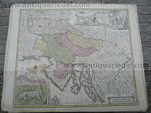
Hardcover. Condition: very good. Exactissima Ducatus Carniolae Histriae, Lotter T.C., anno 1760 Exactissima Ducatus Carniolae Vinidorum Marchi� et Histriae delineatio - Altkol. Kupf.-Kte. von Lotter T.C., anno 1760. Mit 3 fig. u. herald. Kart. mit kl. kol. Nebenkarte (Zirknitzer See). Blattma�: 53x65 cm., gering gebr�unt. Karte von Slowenien, Istrien und n�rdliche Teil Kroatiens.
-
Trevirensis-Archi-Episcopatus, 1760, Lotter T.C. Dekorative, alt
Published by Lotter C.T., 1717-1777, 1777
Map
Kein Einband. Condition: Gut. Trevirensis-Archi-Episcopatus, 1760, Lotter T.C. Dekorative, altkolorierte Karte des Erzbistums Trier: das Gebiet zwischen D�ren, Siegen, Dillenburg, Oppenheim, Mainz und Echternach. Blattma�: 53x65 cm., zeitgen�ssisches Verlagskolorit.
-

Hardcover. Condition: very good. Postal map of France, anno 1760, Lotter T.C., scarce Size of the page: 53x65 cm., contemporary publishers colours, old restored tear on right margin. routes exactes des postes du royaume de France ; Kartenmaterial ; cum gratia et privilegio sac: c�s: maj: ; Matth. Seutter excud ; Description: bibliographic level: Monograph/item; Linear scale; 2600000(Constant ratio linear horizontal scale); Entfernungstabellen links und rechts, Titel oben; Kartusche unten links ("pour la commodit� et la suret� des vo�ageurs, car cel'u� qui demande beaucoup s'egare le plus souvent et se retarde").
-
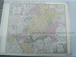
Hardcover. Condition: very good. Hessen, anno 1760, Lotter T.C., altkoloriert "Mappa Circuli Rhenani superioris." Blattma�: 53x65 cm., sehr sch�nes Verlagskolorit, nahezu fleckenfrei. Die Karte wird begrenzt durch Schweinfurt, Eisenach, Schmalkalden im Osten, Wertheim, Darmstadt, Alzey im S�den, Koblenz im Westen und G�ttingen im Norden. Seltenes Blatt von Lotter.
-

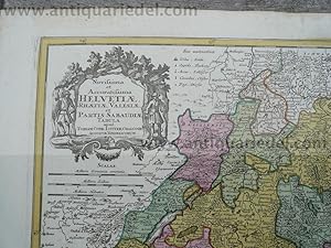
Hardcover. Condition: Gut. Schweiz, anno 1760, Lotter C.T., altkolorierte Karte Lotter, Tobias Conrad: Novissima et Accuratissima Helvetiae, Thaetiae, Valesiae, et Partis Sabaudiae Tabula. Apud Tobiam Conr. Lotter, chalcogr. Augustae Vindelicorum. Circa anno 1760 altkolor. Kupferstichkarte mit florealer Kartusche, von J�gern und einem Hund flankiert, Plattengr�sse 48,5 x 56,5 cm., altkoloriert, gering gebr�unt.


![Seller image for Marchionatus Onoldini Comitatus Oettingensis Praepositurae Elevacensis Et Pappenheimensis. - Markgrafschaft Ansbach �ttingen Pappenheim - 1 Landkarte, Kupferstich [1740] for sale by Antiquariat Lastovka GbR](https://pictures.abebooks.com/inventory/md/md30436188027.jpg)


