Order Total (1 Item Items):
Shipping Destination:

National Map Company (18 results)
Skip to main search results
Product Type
- All Product Types
- Books (15)
- Magazines & Periodicals
- Comics
- Sheet Music
- Art, Prints & Posters
- Photographs
- Maps (3)
-
Manuscripts &
Paper Collectibles
Condition
- All Conditions
- New
- Used
Binding
Collectible Attributes
- First Edition (3)
- Signed
- Dust Jacket
- Seller-Supplied Images (9)
- Not Printed On Demand
Free Shipping
Seller Location
Seller Rating
-

Historical Northern California Mother Lode #1 (Vol. 1, No. 1)
Published by National Heritage Map Company, 1984
ISBN 10: 0935536426ISBN 13: 9780935536423
Book First Edition
Soft cover. Condition: Near Fine. 1st Edition. Near fine copy in spiral bound soft cover. Numbered 94 of 500 copies.
-

THE OFFICIAL MAPS OF NEW YORK: Compiled From United States Government Surveys, Official State Surveys, And Original Sources
Published by The National Survey Co., Chester, VT, 1922
Seller: Riverow Bookshop, Owego, NY, U.S.A.
Seller Rating:

Paperback. Condition: Good/NO DUSTJACKET. Maps (illustrator). Chester, VT: The National Survey Co. Good/NO DUSTJACKET. 1922. . Paperback. 8vo., 80pp, Book has wear and staining to cover, edges and corners. Pages clean and unmarked. .
-
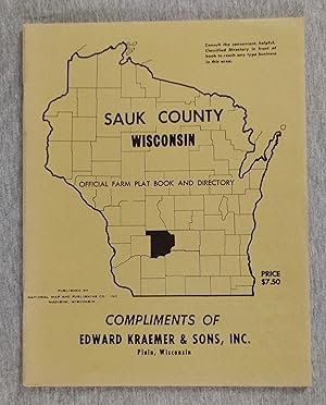
Sauk County Wisconsin Official Farm Plat Book and Directory (1971)
Published by National Map and Publishing Co., Madison, Wisconsin, 1971
Softcover. Condition: Fine. no jacket. Green wraps, 36 pages, 11 in tall. Township and farm maps throughout.
-
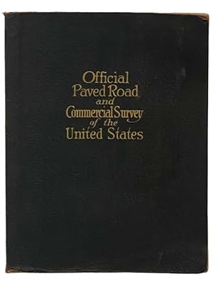
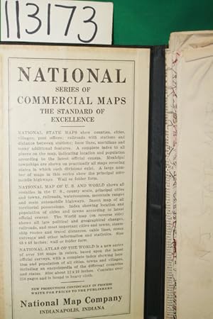
OFFICIAL PAVED ROAD and COMMERCIAL SURVEY of the UNITED STATES
Published by National Map Company, Indianapolis, 1929
Paperback. Condition: Fair. Edition 1283. Section torn from front cover, endpapers discolored from red dye on inside of cover ; Folio - over 12 - 15" tall.
-
HARDCOVER BLACK. Condition: GOOD+. NJ state Map 1917 and first paragraph inside front board, 39" X 48, delicate, few creased edges separated. DATE PUBLISHED: 1917 EDITION:
-
The Southern National Omnibus Company Limited. Official Time Table, Somerset & Dorset Area, 2nd June, 1957
Published by The Southern National Omnibus Company Ltd., Exeter., 1957
First Edition
Hardcover. Condition: Very Good. No Jacket. Folding map. (illustrator). 1st Edition. First edition thus, 2nd June, 1957, Folding map at the end. Some foxing to the page edges. Publishers pictorial coloured paper wrappers. the top of the spine is very slightly split and with some very slight rubbing to the edges. Generally a very good attractive copy in its highly decorative wrappers. Scarce early bus time table. 136 p. Book.
-
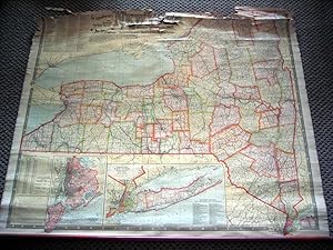
National Map Company's County and Township Map of New York ( Wall Map) Shows Main Highways
Published by National Map Company, Indianapolis, 1921
Map
55 1/2 x 45 inches. This is a very large scale map of New York state at a time when passenger train traffic had peaked and roads were intoduced to the map. It is highly informative and well indexed. See pics. The map is a compendium of geography for this state. Transportation is the primary theme even though the map is titled county and township map. Major Auto Trails are noted in bold red type. This is a superb example of the mapmakers art on the early 20th century. Very good condition for this large of a map. There are separations at many fold intersections. There are a few separations at the folds expertly repaired with archival mending tape.
-
National Publishing Company's New Railroad, Post Office, Township and County Map of New York State [NY] With Distances Between
Published by National Publishing Company, Boston, 1903
Book
Hardcover. Condition: Very Good/No Jacket as issued. Maps (illustrator). Cloth-backed and bound accordion-style into original gilt- stamped black cloth boards. A very presentable copy of a scarce New York State map. Inset of New York City. A couple of seams have small splits and a few more show some wear. Seldom found as nice as this.
-
National Publishing Company's New Railroad, Post Office, Township, and County Map of New York with Distances Between Stations. Compiled From the Latest Government and State Surveys and Original Sources
Published by National Publishing Company, [ca. 1905 ] Boston, 1905
Cloth. Condition: Fair. This is a very detailed, handsome and at the bottom are 2 large- scale map insets: "Map of New York City (Greater New York) and Vicinity" and "Southeastern Part of New York including all of the City of New York, and Long Island."; on a scale of one half mile to the inch; rolled map size: 39-1/4 x 44-1/4in, with printed color; Numerous tables and charts, including: "List of all Steam Railroads in New York State," "Steamship Lines from New York, Jersey City and Hoboken," "County and County Seats, from Census of 1900."; reference: not in Rumsey; the map has browning from the chemical coating; it is cloth-backed, rolled and with long wood at bottom but not at top; tiny tears to the edges; the top of the map is badly torn and needs repairs; but the map is clear except for the top, otherwise in FAIR COND.
-
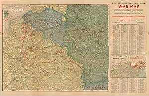
New Detailed Complete War Map of the European Battle Front with Complete World Map - Comprehensive overview of the First World War issued in the beginning of its final year.
Publication Date: 1918
Seller: Curtis Wright Maps, Berwyn, IL, U.S.A.
Seller Rating:

Condition: Very Good. Sheet Width (in) 33.8 Sheet Height (in) 22 Condition Description "Large pocket map originally issued folded into 24 sections. Now flattened, but remains affixed to the original red paper covers, which are worn. The front cover is soiled on the right side and has a coupon for a free "After the War Atlas" affixed to the inside. Several areas of wear and separation along fold lines, repaired on verso. Minimal image loss near Calais.".
-
NEW COMMERICAL AND ROAD MAP OF OREGON [LINEN BACKED POCKET MAP]
Published by National Map Co, Indianapolis, IN, 1920
First Edition
Hardcover. Condition: Very Good. 1st Edition. no date (Ca 1920) Population of state listed at 848,000, Huge Color FoldOut Map (39 x 50 Inches, Folds to 5.5 x 8.25 Inches), Linen Backed, in Blk Nubby Hardback Binder, slight separation at one fold else VG, Assumed 1st ed (Neat).
-
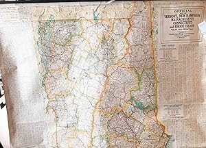
Official Map of Vermant, New Hampshire, Massachusetts, Connecticut and Rhode Island and Maine Wall Map
Published by National Map Company, Indianapolis, 1926
unbound. Condition: Very good. Early. large heavy paper rolled map , ca. 42" x 54 ", rolled to ca. 5" x 56" wall map intended for any use desired from teaching to route planning etc. Has Maine on one side and all the other New England states on the other side. Stated that it is updated with the latest local census data and stated that this was 1925 for a few states. Publication date not noted, but, ca. 1926. This copy, generally, in very good condition with bright colors, no significant tears or major damage. Some dirt that may come off easily toward top and bottom some brown areas. Metal rods at top and bottom for hanging - bottom one is bent, but quite functional, cloth strip for hanging the map still present and usable . Will be mailed rolled in a tube or long square box. Note: shipping outside the USA cost more than that of an average book.
-
Official Paved Road and Commercial Survey of the United States: Sectional Road Maps Covering the Entire United States and Lower Canada - Complete Series of State Maps in Colors for Commercial Reference - a Double Page United States Map Showing Transcontinental Highways - Logs, Transcontinental Federal Highways - Map and Information Concerning Air Mail and Air Express - Maps of Principal Cities in the United States Showing Main Highways - Ready Reference Index Locating Cities, Towns and Villages with Population According to Latest Federal Census - Descriptive Gazetteer of United States and Territorial Possessions.
Published by National Map Company, 1929
Seller: Yesterday's Muse, ABAA, ILAB, IOBA, Webster, NY, U.S.A.
Association Member: ABAA ILAB IOBA
Seller Rating:
Large Softcover. Condition: Good. Reprint. Edition 1283.' Corners worn, covers a bit soiled, crease to bottom corner. 1929 Large Softcover. xlviii, 29-116 pp. Fabricoid cover over post-bound text block. Ten publisher coupons for ordering of revised maps bound in after text. A particularly important road atlas, in that it is among the first to include the newly numbered federal highway system -- the Bureau of Public Roads and the Federal Highway Administration teamed up to accomplish these name changes in 1925 (State Planning & Research Guide, Vol. 59, No. 4, Spring 1996). OCLC lists four different editions of this title, printed in 1928, 1929, 1931, and 1935. The first two are based on the 1920 census, the second two on the 1930 census. The 1929 edition is designated as 'Edition 1263'. Also includes two pages on national parks, an extensive index, and gazetteer.
-
Official paved road and commercial survey of the United States.
Published by National Map Company, Indianapolis, 1921
Book
Soft cover. Condition: Very Good. 1921. 116 pages maps (some color) 39 cm. Sectional road maps also cover Lower Canada. Date is estimated, based on the population for the states being most similar to the 1920 census. OCLC lists one copy of this atlas with 116 pages and provides an estimated date of 192?.That's the only copy known. Maps of each state in color, showing the road system in existence at that time. Most similar to Rand McNally's commercial atlas series, but the relationship with Rand McNally is unclear. This copy with the original flexible binding in very condition except that the title on the cover is quite faded. The interior in very good condition, with the original tissue frontis still present, but loose from the rivets holding the remainder of the book together. Extremely rare.
-
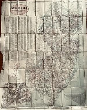
New Commercial and Road Map of New Jersey Showing Counties in Different Colors, Townships, Cities, Villages andPost Offices, Steam and Electric railroads with Stations and Distances between Stations, Complete Index to All Places on Map with Population According to the Latest Census, Roads and Highways
Published by National Map Company, Indianapolis, 1917
Map
48 x 36 3/4 inches. Condition: Very good condition. This is a spectacular large scale map of New Jersey on the eve of WWI. The detail is superb as described by the subtitle of the map. If framed, the map would be a conversation piece of magnitude. A book could be written on the contents of this map. Included are insets maps of congressional districts and Greater New York.
-
Condition: Fine. The book is in fine condition.
-
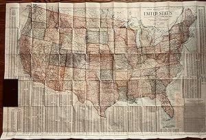
New Standard Map of the United Steaes Showing States in Different Colors, Counties, cities, Villages and Stations With Distances in Statute Miles along Railroads and Other Features-- Completely Indexed
Published by The National Map Company, Indianapolis, 1920
Map
58 3/4 x 39 inches. This is a large scale, highly detailed map of the United States. On the verso is a highly detailed transportation map of the world. There are a preponderance of railroads connecting the towns of the country. The landscape is a railroad landscape with the year of publication being the apex of railroad passenger carriage. Additionally there is a superimposed network of highways indexed by name. This, according to Athon Westward was the year that the pathfinders of the road system finished their work. The pathfinders were mostly engineers who traveled about the named trails mapping the details and routing the roads where necessary.(1) This map combines all the latest data into a compilation of tremendous coverage. The Worldcat search turns up one copy with both maps and one copy of the 1920 edition with both maps. Given the appropriate transportation focus, this map is a must for the collector of U.S. transportation and/or World transportation. (1) Newgard, Anthon L, Tales of Pathfinding, Publisher- A. L. Westward, Washingon:1920, p. 8. Very good with minor separations at the fold junctions.
-
An Account of six years residence in Hudson's-Bay, From 1733to 1744to 1747. By . Containing a Variety of Facts, Observations, and Discoveries, tending to shew, I. The vast Importance of the Countries about Hudson's-Bay to Great-Britain, on Account of the Extensive Improvements taht may be made there in many beneficial Articles of Commerce, particularly in the FURS and in the WHALE and SEAL FISHERIES. And, II. The interested Views of the Hudson's Bay Company; and the absolute Necessity of lying open the Trade, and making it the absolute Necessity of laying open the Trade, and making it the Object of NATIONAL ENCOURAGEMENT, as the only Method of keeping it out of the hands of the French. To which is added an APPENDIX .First EditionLondon 1752. (Printed for J. Payne and J Bouquet.). 8vo. (4, one advert leaf), vi, 95, (1) p. Two folding engraved maps & 1folding engraved plate. Contemporary full calf. Gilt on spine. Hinges repaired and strengthened, edges of covers lightly worn. Interior cl
Seller: Antiquariat Kainbacher, Baden bei Wien, Austria
Seller Rating:
London, Printed for J. Payne and J Bouquet 1752. 8vo. (4, one advert leaf), vi, 84, 95, (1) p. Two folding engraved maps & 1folding engraved plate. Half panelled calf gilt, elaborately gilt spine, fine copy. Joseph Robson was surveyor and supervisor of the buildings of the Hudson's Bay Company."Robson's book was of prime importance, since it was the earliest to reflect first-hand knowledge of service with the Hudson?s Bay Company, and was written by someone who had spent six years in Hudson Bay. Displaying maps, tables of winds and tides, and statistics of the costs incurred in building Prince of Wales Fort, it had an authentic ring, "honest and just" as one reviewer described it. Its criticisms of the Hudson?s Bay Company were consequently the more telling, with stories of oppressive behaviour by the company factors, their refusal to explore the interior, and their incompetence in building work. . Recent investigations have shown that Arthur Dobbs, not Robson, wrote the long and polemic appendix, and that he also revised Robson's text. Dobbs, who wanted Robson to be more involved with the search for the North-West Passage must have been disappointed with Robson?s findings. After a lengthy exploration, Robson like Middleton could find no route through and turned his attention to improving conditions and critising the Hudson Bay Company. Appendix I, p. 1-67 is based on the unpublished journal of Groseillers' expedition to the Bay in 1668-69 by his ship Captain Zachariah Gillam.and on Company papers." The maps depict the Nelson and Hayes Rivers, the Plans of York and Prince of Wales Forts, and the Churchill River. Field 1312; Graff 3532; Sabin 72259; Smith 8728; Hill 1477; TPL 217; Lande 1418 (both call only for 2 plates); Staton and Tremaine, 217.