Order Total (1 Item Items):
Shipping Destination:

Nirenstein Nathan Compiled Bowers (1 results)
Skip to main search results
Product Type
- All Product Types
- Books (1)
- Magazines & Periodicals
- Comics
- Sheet Music
- Art, Prints & Posters
- Photographs
- Maps
-
Manuscripts &
Paper Collectibles
Condition
- All Conditions
- New
- Used
Binding
- All Bindings
- Hardcover
- Softcover
Collectible Attributes
- First Edition
- Signed
- Dust Jacket
- Seller-Supplied Images
- Not Printed On Demand
Seller Location
Seller Rating
-
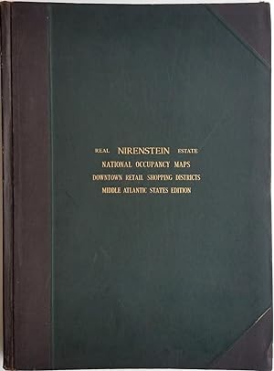
Nirenstein's Middle Atlantic States Edition. Preferred Real Estate Locations of Business Properties in Fifty Principal Cities, the Most Extensive Central Real Estate Survey Ever Compiled
Published by Nirenstein's National Realty Map Co., Springfield, Mass, 1947
Seller: Antipodean Books, Maps & Prints, ABAA, Garrison, NY, U.S.A.
Association Member: ABAA ANZAAB ESA ILAB
Seller Rating:

Hardcover. Condition: Very good condition. An impressive atlas of maps of the downtown retail shopping districts of cities in the middle Atlantic states of New Jersey, New York, Maryland, Delaware, and the District of Columbia, with each city's businesses identified on every block. This was an invaluable guide to potential investors and store owners of the day. One such store can be seen on the Brooklyn map, which shows Abraham & Straus, the emporium which opened in 1883 transforming downtown Brooklyn. At the same time this Atlas of the Middle Atlantic States was published, the New England city guide was being marketed at $200, the equivalent of $2,653 in 2017. Accompanying text provides information on population, principal industries, department stores, drug stores, grocery stores, city transportation, highways, banks, utilities, schools and hospitals. Illustrations include b&w printed photographic aerial views of city centers, landmark buildings, libraries and colleges. A folding map of White Plains NY, showing Harchester Park, an office park development, loosely inserted. Elephant folio (20 X 27"), 102 leaves, including 50 double-page maps. The text, maps and photographic illustrations (from aerial photographs) printed in blue ink . Three quarter dark brown leatherette and dark green buckram boards, leather index tabs at foredges of leaves. The front free end paper with sticky tape at foredge; all the maps bright and fresh. OCLC: 656278404 records 4 copies.