Order Total (1 Item Items):
Shipping Destination:

Ptolemy Sebastian Münster Giacopo Gastaldi (4 results)
Skip to main search results
Product Type
- All Product Types
- Books (4)
- Magazines & Periodicals
- Comics
- Sheet Music
- Art, Prints & Posters
- Photographs
- Maps
-
Manuscripts &
Paper Collectibles
Condition
- All Conditions
- New
- Used
Binding
- All Bindings
- Hardcover
- Softcover
Collectible Attributes
- First Edition
- Signed (1)
- Dust Jacket
- Seller-Supplied Images
- Not Printed On Demand
Seller Location
Seller Rating
-
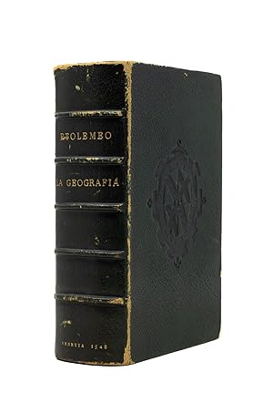
Ptolemeo La Geografia di Claudio Ptolemeo Alessandrino, Con alcuni comenti & aggiunte fattevi da Sebastiano munstero Alamann, Con le tavole non solamente antiche & moderna solite di stăparsí, ma altre nuove aggiuntevi di Messer Iacopo Gastaldo Piamőtese cosmographo, ridotta in volgare Italiano da M. Pietro Andrea Mattiolo Senese medico Eccelętißimo con l'aggiunta d'infiniti nomi moderni, di Cittŕ, Provincie, Castella, et altri luoghi, fatta cő grandissima diligenza da esso Meser Iacopo Gastaldo, il che in nissun altro Ptolemeo si ritrova. Opera veramente non meno utile che necessaria
Published by Giovanbattista Pedrezano (for Nicolo Bascarini), Venice, 1548
First Edition Signed
Hardcover. Condition: Very good. First. THE STIRLING-MAXWELL COPY. First complete edition in Italian, first octavo edition. Venice: Giovanbattista Pedrezano (for Nicolo Bascarini), 1548. Small octavo (6 1/4" x 4 1/8", 159mm x 105mm). [Full collation available.] With 60 double-page engraved maps integral with the text. Bound in XIXc green morocco by Leighton of Brewer St. (signed at the upper edge of the verso of the front free end-paper) with the blind armorial supralibros of Stirling-Maxwell. On the spine, five raised bands. Author gilt to the second panel, title gilt to the third, imprint to the tail. Gilt inside dentelle. Red-painted end-papers. All edges of the text-block gilt. Scuffed at the extremities, with some wear to the fore-corners. Starting at the head. Some worming to the red of the first free end-paper. Small filled loss to the bottom margin of the title-page, not affecting the text. Lacking the blank DD8 and the final leaf (h8), which is supplied in facsimile. Generally mildly tanned. Underlining to fol. 94r and to pll. 291r, 311r, 341r (all three depicting Africa). Armorial bookplate of Sir William Stirling Maxwell to the front paste-down. Claudius Ptolemaeus (usually anglicized to Ptolemy) was a second-century philosopher living in Roman Alexandria in Egypt. In the Greek tradition (Ptolemy wrote in Greek, which was the administrative language of the Roman Empire in the Eastern Mediterranean), philosophy -- the love of wisdom -- bridged what we now divide into the humanities and the sciences; he was a mathematician, natural scientist and geographer-astronomer. No manuscripts of the Geographical Guidance survive from before the XIIIc, but some XIIIc examples survive with maps that bear some relation to those Ptolemy himself drew. In the XVc, the Geographia was the core of ancient knowledge of the world, extending from the Canary Islands in the West to China in the East (though not quite to the Pacific), Scandinavia in the North and beyond the Horn of Africa to the South. It was crucial to explorers; Columbus expected to find the East Indies because of Ptolemy's calculations and assertions about longitude. As the world expanded beyond its ancient bounds, discoveries were integrated into the Ptolemaic maps, distinct with their trapezoidal frames. The 1548 (col.: October 1547) edition of Ptolemy stands apart from earlier issues. It is the first "pocket" issue of the work, making it at least plausible for it to accompany an explorer. The commentary of Sebastian Münster -- a truly pan-European humanist effort -- and the text of Ptolemy were both translated by Pietro Andrea Mattioli (Matthioli), better known as the botanist and translator of Dioscorides. Gastaldi's 60 maps -- he was also responsible for updating and adding modern place names, a massive task reflected in the 127-page index -- are unusually decorative as well as up-to-date, especially given their diminutive size. There is a robust group non-European maps, with particular focus on the Silk Road and India (maps 46-53) and 5 maps of the Americas (54-48) -- including the first regional maps of North America. (Indeed, Nordenskiöld dubs this "the very first atlas of the new world.") The two world maps (one a sea chart) show the turning-point in the understanding of the world. Both continue to conceptualize America as connected to Asia, though the world map proper is beginning to conceive of a break between northwestern America and northeastern Asia. Sir William Stirling-Maxwell (1818-1878; until 1865 he was known as William Stirling, whereupon he acceded to the Baronetage of Nova Scotia and adopted the additional surname) was Chancellor of the University of Glasgow and an author on various subjects, most notably on illustrated books. Adams P 2234; Alden & Landis 548/31; Burden, North America 16 & 17; Edit16 CNCE 47524; Harrisse, BAV 285; JCB(3) I:153; Mortimer, Italian 404; Nordenskiöld 2:214; Phillips, Atlases 369; Sabin 66502; Shirley, Mapping of the World 87 & 88; Streeter sale 1.
-
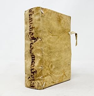
Ptolemeo La Geografia di Claudio Ptolemeo Alessandrino, Con alcuni comenti & aggiunte fattevi da Sebastiano munstero Alamann, Con le tavole non solamente antiche & moderna solite di stăparsí, ma altre nuove aggiuntevi di Messer Iacopo Gastaldo Piamőtese cosmographo, ridotta in volgare Italiano da M. Pietro Andrea Mattiolo Senese medico Eccelętißimo con l'aggiunta d'infiniti nomi moderni, di Cittŕ, Provincie, Castella, et altri luoghi, fatta cő grandissima diligenza da esso Meser Iacopo Gastaldo, il che in nissun altro Ptolemeo si ritrova. Opera veramente non meno utile che necessaria
Published by Giovanbattista Pedrezano (for Nicolo Bascarini), Venice, 1548
First Edition
Hardcover. Condition: Near fine. First. First complete edition in Italian, first octavo edition. Venice: Giovanbattista Pedrezano (for Nicolo Bascarini), 1548. Small octavo (6 3/8" x 4 1/4", 162mm x 109mm). [Full collation available.] With 60 double-page engraved maps integral with the text. Bound in contemporary stabbed vellum with yapp edges and four pig-skin ties. Author and title manuscript to the spine in an old hand (XVIc?): "ClaudioPtolomeo.Geograf". Lower front tie perished. Binding a little soiled but overall very good. Some repairs to the front joint (end-papers renewed?), with the title-leaf (â 1) re-mounted. Lacking â 3 (dedication to Leone Strozzi). Closed tear to the lower margin of CC8 (not affecting the text). Fresh internally, with good margins. Ink monogram (?) to the lower edge of the title-page. Graphite marking to I3r, I6v and I7r, ink marking to 12 pages, and ink commentary (usually to other sources) to 17 pages. Place-names in maps 9 ("Germania nova tabula MDXXXXII") and 23 ("Polonia et Hungaria nova tabula") highlighted in brushed sanguine ink. Presented in a grey cloth clam-shell box. Claudius Ptolemaeus (usually anglicized to Ptolemy) was a second-century philosopher living in Roman Alexandria in Egypt. In the Greek tradition (Ptolemy wrote in Greek, which was the administrative language of the Roman Empire in the Eastern Mediterranean), philosophy -- the love of wisdom -- bridged what we now divide into the humanities and the sciences; he was a mathematician, natural scientist and geographer-astronomer. No manuscripts of the Geographical Guidance survive from before the XIIIc, but some XIIIc examples survive with maps that bear some relation to those Ptolemy himself drew. Thus, with the exception of some excavated carved maps, Ptolemy is the source for ancient cartography as well as its culmination. It was crucial to explorers; Columbus expected to find the East Indies because of Ptolemy's calculations and assertions about longitude. As the world expanded beyond its ancient bounds, discoveries were integrated into the Ptolemaic maps, distinct with their trapezoidal frames. The 1548 (colophon dated October 1547) edition of Ptolemy stands apart from earlier issues in various ways. It is the first "pocket" issue of the work, making it at least plausible for it to accompany an explorer. The commentary of Sebastian Münster -- a truly pan-European humanist effort -- and the text of Ptolemy were both translated by Pietro Andrea Mattioli (Matthioli), better known as the botanist and translator of Dioscorides. Gastaldi's 60 maps -- he was also responsible for updating and adding modern place names, a massive task reflected in the 127-page index -- are unusually decorative as well as up-to-date, especially given their diminutive size. There is a robust group non-European maps, with particular focus on the Silk Road and India (maps 46-53) and 5 maps of the Americas (54-48) -- including the first regional maps of North America. (Indeed, Nordenskiöld dubs this "the very first atlas of the new world.") The two world maps (one a sea chart) show the turning-point in the understanding of the world. Both continue to conceptualize America as connected to Asia, though the world map proper is beginning to conceive of a break between northwestern America and northeastern Asia. The annotator(s) of the volume was certainly learned, with cross-references to Girava, Pliny, Solinus, Ortelius and Apianus. From the collection of Charles J. Tanenbaum (d. 2009), sold at Sotheby's New York 11 December 2008 (the present item lot 31) to benefit his Pine Tree Foundation, which has granted funds to the John Carter Brown Library, the New York Public Library, the Grolier Club and other major institutions. Adams P 2234; Alden & Landis 548/31; Burden, North America 16 & 17; Edit16 CNCE 47524; Harrisse, BAV 285; JCB(3) I:153; Mortimer, Italian 404; Nordenskiöld 2:214; Phillips, Atlases 369; Sabin 66502; Shirley, Mapping of the World 87 & 88; Streeter sale 1.
-
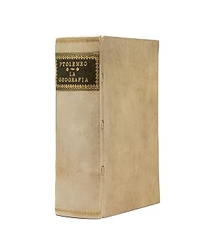
Ptolemeo La Geografia di Claudio Ptolemeo Alessandrino, Con alcuni comenti & aggiunte fattevi da Sebastiano munstero Alamann, Con le tavole non solamente antiche & moderna solite di stăparsí, ma altre nuove aggiuntevi di Messer Iacopo Gastaldo Piamőtese cosmographo, ridotta in volgare Italiano da M. Pietro Andrea Mattiolo Senese medico Eccelętißimo con l'aggiunta d'infiniti nomi moderni, di Cittŕ, Provincie, Castella, et altri luoghi, fatta cő grandissima diligenza da esso Meser Iacopo Gastaldo, il che in nissun altro Ptolemeo si ritrova. Opera veramente non meno utile che necessaria
Published by Giovanbattista Pedrezano (for Nicolo Bascarini), Venice, 1548
First Edition
Hardcover. Condition: Near fine. First. First complete edition in Italian, first octavo edition. Venice: Giovanbattista Pedrezano (for Nicolo Bascarini), 1548. Small octavo (6 5/8" x 4 1/4", 167mm x 108mm). [Full collation available.] With 60 double-page engraved maps integral with the text. Bound in modern laced vellum with yapp edges. On the spine, author and title gilt to green morocco. Tanned in places, with some signs of small local damp or soiling. An old bookseller's description of the work (perhaps this example?) mounted to the verso of the second free end-paper. Gilt booklabel of Lord Wardington to the rear paste-down. Claudius Ptolemaeus (usually anglicized to Ptolemy) was a second-century philosopher living in Roman Alexandria in Egypt. In the Greek tradition (Ptolemy wrote in Greek, which was the administrative language of the Roman Empire in the Eastern Mediterranean), philosophy -- the love of wisdom -- bridged what we now divide into the humanities and the sciences; he was a mathematician, natural scientist and geographer-astronomer. No manuscripts of the Geographical Guidance survive from before the XIIIc, but some XIIIc examples survive with maps that bear some relation to those Ptolemy himself drew. Thus, with the exception of some excavated carved maps, Ptolemy is the source for ancient cartography as well as its culmination. It was crucial to explorers; Columbus expected to find the East Indies because of Ptolemy's calculations and assertions about longitude. As the world expanded beyond its ancient bounds, discoveries were integrated into the Ptolemaic maps, distinct with their trapezoidal frames. The 1548 (colophon dated October 1547) edition of Ptolemy stands apart from earlier issues in various ways. It is the first "pocket" issue of the work, making it at least plausible for it to accompany an explorer. The commentary of Sebastian Münster -- a truly pan-European humanist effort -- and the text of Ptolemy were both translated by Pietro Andrea Mattioli (Matthioli), better known as the botanist and translator of Dioscorides. Gastaldi's 60 maps -- he was also responsible for updating and adding modern place names, a massive task reflected in the 127-page index -- are unusually decorative as well as up-to-date, especially given their diminutive size. There is a robust group non-European maps, with particular focus on the Silk Road and India (maps 46-53) and 5 maps of the Americas (54-48) -- including the first regional maps of North America. (Indeed, Nordenskiöld dubs this "the very first atlas of the new world.") The two world maps (one a sea chart) show the turning-point in the understanding of the world. Both continue to conceptualize America as connected to Asia, though the world map proper is beginning to conceive of a break between northwestern America and northeastern Asia. The present example was in the collection of Sir (Robert) Leicester Harmsworth, Bt. (1870-1937), who in addition to being a director at Amalgamated Press -- which at its zenith owned the Daily Mail, The Observer and the Times -- was also an MP for Caithness (and Sutherland). It was lot 9239 of his sale at Sotheby's London, 9 June 1952. It was again offered at Sotheby's by an undesignated consignor 18 July 1961 (lot 531), when it was bought by Charles W. Traylen on behalf of Christopher Henry Beaumont Pease, 2nd Baron Wardington (1924-2005). Lord Wardington was a book collector of great renown, building a splendid library at his Oxfordshire home, Wardington Manor. His particular interest was the very finest examples of cartography. His sale (part two, Sotheby's London, 10 October 2006; the present item lot 403) was a landmark in the field, and its catalogue practically a reference work in its own right. Adams P 2234; Alden & Landis 548/31; Burden, North America 16 & 17; Edit16 CNCE 47524; Harrisse, BAV 285; JCB(3) I:153; Mortimer, Italian 404; Nordenskiöld 2:214; Phillips, Atlases 369; Sabin 66502; Shirley, Mapping of the World 87 & 88; Streeter sale 1.
-
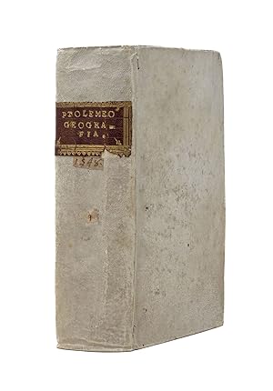
Ptolemeo La Geografia di Claudio Ptolemeo Alessandrino, Con alcuni comenti & aggiunte fattevi da Sebastiano munstero Alamann, Con le tavole non solamente antiche & moderna solite di stăparsí, ma altre nuove aggiuntevi di Messer Iacopo Gastaldo Piamőtese cosmographo, ridotta in volgare Italiano da M. Pietro Andrea Mattiolo Senese medico Eccelętißimo con l'aggiunta d'infiniti nomi moderni, di Cittŕ, Provincie, Castella, et altri luoghi, fatta cő grandissima diligenza da esso Meser Iacopo Gastaldo, il che in nissun altro Ptolemeo si ritrova. Opera veramente non meno utile che necessaria
Published by Giovanbattista Pedrezano (for Nicolo Bascarini), Venice, 1548
First Edition
Hardcover. Condition: Near fine. First. First complete edition in Italian, first octavo edition. Venice: Giovanbattista Pedrezano (for Nicolo Bascarini), 1548. Small octavo (6 1/2" x 4 3/8", 165mm x 110mm). [Full collation available.] With 60 double-page engraved maps integral with the text. Claudius Ptolemaeus (usually anglicized to Ptolemy) was a second-century philosopher living in Roman Alexandria in Egypt. In the Greek tradition (Ptolemy wrote in Greek, which was the administrative language of the Roman Empire in the Eastern Mediterranean), philosophy -- the love of wisdom -- bridged what we now divide into the humanities and the sciences; he was a mathematician, natural scientist and geographer-astronomer. No manuscripts of the Geographical Guidance survive from before the XIIIc, but some XIIIc examples survive with maps that bear some relation to those Ptolemy himself drew. Thus, with the exception of some excavated carved maps, Ptolemy is the source for ancient cartography as well as its culmination. It was crucial to explorers; Columbus expected to find the East Indies because of Ptolemy's calculations and assertions about longitude. As the world expanded beyond its ancient bounds, discoveries were integrated into the Ptolemaic maps, distinct with their trapezoidal frames. The 1548 (colophon dated October 1547) edition of Ptolemy stands apart from earlier issues in various ways. It is the first "pocket" issue of the work, making it at least plausible for it to accompany an explorer. The commentary of Sebastian Münster -- a truly pan-European humanist effort -- and the text of Ptolemy were both translated by Pietro Andrea Mattioli (Matthioli), better known as the botanist and translator of Dioscorides. Gastaldi's 60 maps -- he was also responsible for updating and adding modern place names, a massive task reflected in the 127-page index -- are unusually decorative as well as up-to-date, especially given their diminutive size. There is a robust group non-European maps, with particular focus on the Silk Road and India (maps 46-53) and 5 maps of the Americas (54-48) -- including the first regional maps of North America. (Indeed, Nordenskiöld dubs this "the very first atlas of the new world.") The two world maps (one a sea chart) show the turning-point in the understanding of the world. Both continue to conceptualize America as connected to Asia, though the world map proper is beginning to conceive of a break between northwestern America and northeastern Asia. The marks of ownership suggest the volume went through several collections, but all are either obliterated or so generic as to defy assessments of ownership. Purchased at the sale of Francis Anthony Benevento II at Sotheby's London (6 May 2010, lot 1). Frank Benevento (1947-2023) was a lawyer and later an investment banker with Lehman Brothers who began his collection of great maps and atlases here at Arader Galleries. Our purchasing dominated his sale. Adams P 2234; Alden & Landis 548/31; Burden, North America 16 & 17; Edit16 CNCE 47524; Harrisse, BAV 285; JCB(3) I:153; Mortimer, Italian 404; Nordenskiöld 2:214; Phillips, Atlases 369; Sabin 66502; Shirley, Mapping of the World 87 & 88; Streeter sale 1.