Order Total (1 Item Items):
Shipping Destination:

Robert Vaugondy Gilles Didier (143 results)
Skip to main search results
Product Type
- All Product Types
- Books (20)
- Magazines & Periodicals
- Comics
- Sheet Music
- Art, Prints & Posters (9)
- Photographs
- Maps (114)
-
Manuscripts &
Paper Collectibles
Condition
- All Conditions
- New
- Used
Binding
Collectible Attributes
- First Edition (2)
- Signed
- Dust Jacket
- Seller-Supplied Images (141)
- Not Printed On Demand
Free Shipping
Seller Location
Seller Rating
-
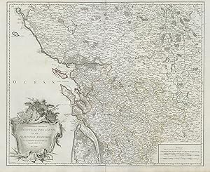
Gouvernemens G�n�raux du Poitou, du Pays d'Aunis, et de Saintonge-Angoumois, Par le Sr. Robert de Vaugondy fils Geographe ordinaire du Roi. Avec Privilege
Publication Date: 1947
Map
Condition: Good. Gouv. G�n�raux du Poitou, du Pays d'Aunis. Charente. VAUGONDY Repro. 1947 map. 20th century uncoloured reproduction of a large antique 18th century atlas map; Robert de Vaugondy, Gilles & Didier (1947 reproduction of a map originally published in 1753). 50.0 x 61.5cm, 19.75 x 24.25 inches; this is a folding map. Condition: Good. There are text and/or images printed on the reverse side.
-
Condition: Good. "Cercle de Franconie". Franconia, Germany. Northern Bavaria. VAUGONDY 1752 map. Large antique 18th century atlas map, printed on thick, good quality paper with original outline hand colour/color and decorative title cartouche; Robert de Vaugondy, Gilles & Didier (1752). 49.5 x 59.0cm, 19.5 x 23.25 inches; this is a folding map. Condition: Good. There is nothing printed on the reverse side, which is plain.
-
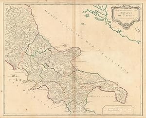
Partie Septentrionale du Royaume de Naples, par le Sr. Robert, Geographe ordin. du Roy. Avec Privilege
Publication Date: 1750
Map
Condition: Good. "Partie Septentrionale du Royaume Naples". Italy Southern. VAUGONDY 1750 map. Large antique 18th century atlas map, printed on thick, good quality paper with original outline hand colour/color and decorative title cartouche; Robert de Vaugondy, Gilles & Didier (1750). 50.0 x 62.0cm, 19.5 x 24.25 inches; this is a folding map. Condition: Good. There is nothing printed on the reverse side, which is plain.
-
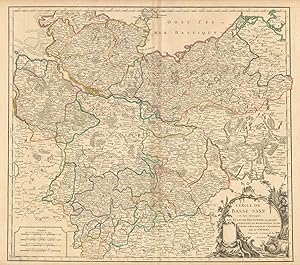
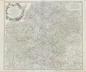
Cercle de Basse Saxe o� sont distingu�s les Etats de Brunswich, les Duch�s de Holstien de Mecklenbourg et des Ev�ch�s d'Hildesheim, et d'Halberstadt. Par le Sr. Robert G�ographe ordinaire du Roy. Avec Privilege
Publication Date: 1752
Map
Condition: Good. "Cercle de Basse Saxe" Niedersachsen Mecklenburg Holstein. VAUGONDY 1752 map. Large antique 18th century atlas map, printed on thick, good quality paper with original outline hand colour/color and decorative title cartouche; Robert de Vaugondy, Gilles & Didier (1752). 50.0 x 56.5cm, 19.75 x 22.25 inches; this is a folding map. Condition: Good. There is nothing printed on the reverse side, which is plain.
-
Condition: Good. "Cercle de Franconie". Franconia. Northern Bavaria. Germany. VAUGONDY 1752 map. Large antique 18th century atlas map, printed on thick, good quality paper with original outline hand colour/color and decorative title cartouche; Robert de Vaugondy, Gilles & Didier (1752). 50.0 x 60.0cm, 19.75 x 23.5 inches; this is a folding map. Condition: Good. There is nothing printed on the reverse side, which is plain.
-

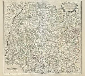
Cercle de Souabe dans lequel sont distingu�s les principaux etats, et les enclaves de la Maison d'Autriche. Par le Sr. Robert Geographe ord. du Roy. Avec Privilege
Publication Date: 1751
Map
Condition: Good. "Cercle de Souabe". Swabia. SW Germany. Baden-W�rttemberg. VAUGONDY 1751 map. Large antique 18th century atlas map, printed on thick, good quality paper with original outline hand colour/color and decorative title cartouche; Robert de Vaugondy, Gilles & Didier (1751). 50.0 x 55.5cm, 19.5 x 22 inches; this is a folding map. Condition: Good. There is nothing printed on the reverse side, which is plain.
-
Cercle de Souabe dans lequel sont distingu�s les principaux etats, et les enclaves de la Maison d'Autriche. Par le Sr. Robert Geographe ord. du Roy. Avec Privilege
Publication Date: 1751
Map
Condition: Good. "Cercle de Souabe". Swabia. Baden-W�rttemberg. SW Germany. VAUGONDY 1751 map. Large antique 18th century atlas map, printed on thick, good quality paper with original outline hand colour/color and decorative title cartouche; Robert de Vaugondy, Gilles & Didier (1751). 50.0 x 56.5cm, 19.75 x 22.25 inches; this is a folding map. Condition: Good. There is nothing printed on the reverse side, which is plain.
-

Condition: Good. "Le Tyrol sous le nom duq'uel" Tirol & Trentino-Alto Adige. VAUGONDY 1753 map. Large antique 18th century atlas map, printed on thick, good quality paper with original outline hand colour/color and decorative title cartouche; Robert de Vaugondy, Gilles & Didier (1753). 50.0 x 57.5cm, 19.75 x 22.75 inches; this is a folding map. Condition: Good. There is nothing printed on the reverse side, which is plain.".
-
Condition: Good. "Le Tyrol sous le nom duq'uel" Tirol & Trentino/South Tyrol. VAUGONDY 1753 map. Large antique 18th century atlas map, printed on thick, good quality paper with original outline hand colour/color and decorative title cartouche; Robert de Vaugondy, Gilles & Didier (1753). 50.0 x 58.0cm, 19.75 x 23 inches; this is a folding map. Condition: Good. There is nothing printed on the reverse side, which is plain.".
-
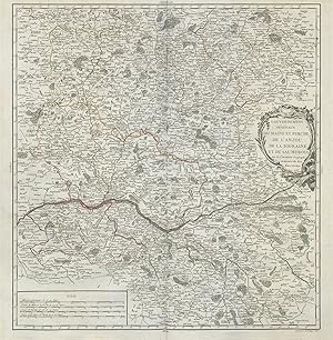
Gouvernemens g�n�raux du Maine et Perche, de l'Anjou, de la Touraine, et du Saumurois. Par le Sr. Robert Geographe Ordinaire du Roi. Avec Privilege
Publication Date: 1753
Map
Condition: Good. "Maine et Perche, de l'Anjou, de la Touraine" Val de Loire. VAUGONDY 1753 map. Large antique 18th century atlas map, printed on thick, good quality paper with original outline hand colour/color and decorative title cartouche; Robert de Vaugondy, Gilles & Didier (1753). 49.5 x 48.5cm, 19.5 x 19.25 inches; this is a folding map. Condition: Good. There is nothing printed on the reverse side, which is plain.".
-
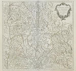
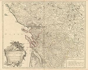
Gouvernement G�n�ral du Dauphin�, divis� par Bailliages, par le Sr. Robert, G�ographe ordin? du Roy. Avec Privilege
Publication Date: 1751
Map
Condition: Good. "Gouvernement G�n�ral du Dauphin�". Is�re Dr�me Hautes-Alpes. VAUGONDY 1751 map. Large antique 18th century atlas map, printed on thick, good quality paper with original outline hand colour/color and decorative title cartouche; Robert de Vaugondy, Gilles & Didier (1751). 50.0 x 53.0cm, 19.5 x 21 inches; this is a folding map. Condition: Good. There is nothing printed on the reverse side, which is plain.
-
Partie Orientale du Gouvernement G�n�ral de la Guienne o� se trouvent le Quercy et le Rouergue. Par le Sr. Robert Geographe ordinaire du Roi. Avec Privilege
Publication Date: 1753
Map
Condition: Good. Partie Orientale du Gouv. G�n�ral de la Guienne. Midi-Pyr�n�es VAUGONDY 1753 map. Large antique 18th century atlas map, printed on thick, good quality paper with original outline hand colour/color and decorative title cartouche; Robert de Vaugondy, Gilles & Didier (1753). 49.0 x 54.0cm, 19.25 x 21.25 inches; this is a folding map. Condition: Good. There is nothing printed on the reverse side, which is plain.
-
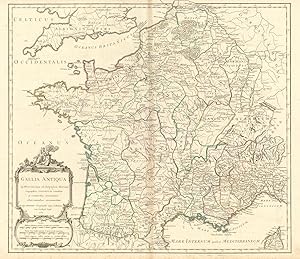
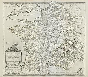
Gallia Antiqua in provincias et Populos divisa, Geographicis Sansonum conatibus et recentioribus Astronomicis observationibus accommodata ab Aeg. Robert Geographo regis ordinario cum Privilegio Regis
Publication Date: 1750
Map
Condition: Good. "Gallia Antiqua in provincias" Roman Gaul. France. VAUGONDY 1750 old map. Large antique 18th century atlas map, printed on thick, good quality paper with original outline hand colour/color and decorative title cartouche; Robert de Vaugondy, Gilles & Didier (1750). 50.0 x 58.0cm, 19.5 x 22.75 inches; this is a folding map. Condition: Good. There is nothing printed on the reverse side, which is plain.".
-

Condition: Good. "Partie M�ridionale de Bourgogne ou Franche-Comt�" Jura Vaud. VAUGONDY 1749 map. Large antique 18th century atlas map, printed on thick, good quality paper with original outline hand colour/color and decorative title cartouche; Robert de Vaugondy, Gilles & Didier (1749). 49.5 x 60.0cm, 19.5 x 23.5 inches; this is a folding map. Condition: Good. There is nothing printed on the reverse side, which is plain.".
-
Partie M�ridionale du Gouvernemt. G�n�ral de Champagne qui comprend la Champagne propre, le Vallage, le Bassigny, le Senonois, et une partie de la Brie et du Perthois. Par le Sr. Robert Geographe ordinaire du Roi. Avec Privilege
Publication Date: 1752
Map
Condition: Good. "Partie M�ridionale du Gouvernemt. G�n�ral de Champagne". VAUGONDY 1752 map. Large antique 18th century atlas map, printed on thick, good quality paper with original outline hand colour/color and decorative title cartouche; Robert de Vaugondy, Gilles & Didier (1752). 49.5 x 67.0cm, 19.5 x 26.25 inches; this is a folding map. Condition: Good. There is nothing printed on the reverse side, which is plain.
-
Gouvernemens G�n�raux du Berry, du Nivernois, et du Bourbonois. Par le Sr. Robert G�ographe ordinaire du Roi. Avec Privilege
Publication Date: 1753
Map
Condition: Good. "Gouv. G�n�raux du Berry, du Nivernois, et du Bourbonois". VAUGONDY 1753 map. Large antique 18th century atlas map, printed on thick, good quality paper with original outline hand colour/color and decorative title cartouche; Robert de Vaugondy, Gilles & Didier (1753). 49.5 x 57.5cm, 19.5 x 22.5 inches; this is a folding map. Condition: Good. There is nothing printed on the reverse side, which is plain.
-
Condition: Fair. "Partie Meridile. du Gouvernement de Guienne" Southwest France VAUGONDY 1753 map. Large antique 18th century atlas map, printed on thick, good quality paper with original outline hand colour/color and decorative title cartouche; Robert de Vaugondy, Gilles & Didier (1753). 50.0 x 64.0cm, 19.5 x 25.25 inches; this is a folding map. Condition: Fair: Blemishes. There is nothing printed on the reverse side, which is plain.
-
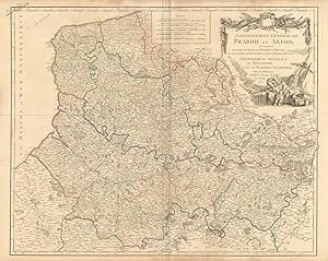
Condition: Good. Hauts-de-France "Gouvernement G�n�rale de Picardie et Artois" VAUGONDY 1753 map. Large antique 18th century atlas map, printed on thick, good quality paper with original outline hand colour/color and decorative title cartouche; Robert de Vaugondy, Gilles & Didier (1753). 50.0 x 63.0cm, 19.75 x 24.75 inches; this is a folding map. Condition: Good. There is nothing printed on the reverse side, which is plain.
-

Gouvermement G�n�ral de l'Isle de France divis� par Pays. Par le Sr. Robert Geographe ord. du Roi. Avec Privilege
Publication Date: 1754
Map
Condition: Good. "Gouvermement G�n�ral de l'Isle de France" Paris �le-de-France VAUGONDY 1754 map. Large antique 18th century atlas map, printed on thick, good quality paper with original outline hand colour/color and decorative title cartouche; Robert de Vaugondy, Gilles & Didier (1754). 50.0 x 55.0cm, 19.5 x 21.75 inches; this is a folding map. Condition: Good. There is nothing printed on the reverse side, which is plain.
-

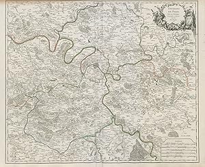
Environs de Paris. Par le Sr. Robert Geographe ordinaire du Roi. Avec Privilege
Publication Date: 1753
Map
Condition: Good. "Environs de Paris". �le-de-France. ROBERT DE VAUGONDY 1753 old antique map. Large antique 18th century atlas map, printed on thick, good quality paper with original outline hand colour/color and decorative title cartouche; Robert de Vaugondy, Gilles & Didier (1753). 50.0 x 62.0cm, 19.75 x 24.25 inches; this is a folding map. Condition: Good. There is nothing printed on the reverse side, which is plain.
-
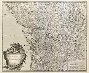
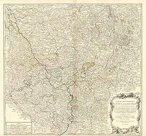
Gouvernemens G�n�raux du Poitou, du Pays d'Aunis, et de Saintonge-Angoumois, Par le Sr. Robert de Vaugondy fils Geographe ordinaire du Roi. Avec Privilege
Publication Date: 1753
Map
Condition: Good. "Gouv. G�n�raux du Poitou, du Pays d'Aunis" Charente Vend�e. VAUGONDY 1753 map. Large antique 18th century atlas map, printed on thick, good quality paper with original outline hand colour/color and decorative title cartouche; Robert de Vaugondy, Gilles & Didier (1753). 50.0 x 62.5cm, 19.75 x 24.5 inches; this is a folding map. Condition: Good. There is nothing printed on the reverse side, which is plain.".
-
Gouvernemens G�n�raux du Poitou, du Pays d'Aunis, et de Saintonge-Angoumois, Par le Sr. Robert de Vaugondy fils Geographe ordinaire du Roi. Avec Privilege
Publication Date: 1753
Map
Condition: Good. "Gouv. G�n�raux du Poitou, du Pays d'Aunis" Vend�e Charente. VAUGONDY 1753 map. Large antique 18th century atlas map, printed on thick, good quality paper with original outline hand colour/color and decorative title cartouche; Robert de Vaugondy, Gilles & Didier (1753). 50.0 x 61.5cm, 19.75 x 24.25 inches; this is a folding map. Condition: Good. There is nothing printed on the reverse side, which is plain.".
-

Partie M�ridionale du Gouvernemt. G�n�ral de Champagne qui comprend la Champagne propre, le Vallage, le Bassigny, le Senonois, et une partie de la Brie et du Perthois. Par le Sr. Robert Geographe ordinaire du Roi. Avec Privilege
Publication Date: 1752
Map
Condition: Good. "Partie M�ridionale de Champagne". Marne Aube Haute Marne. VAUGONDY 1752 map. Large antique 18th century atlas map, printed on thick, good quality paper with original outline hand colour/color and decorative title cartouche; Robert de Vaugondy, Gilles & Didier (1752). 50.0 x 66.5cm, 19.5 x 26.25 inches; this is a folding map. Condition: Good. Light spotting. There is nothing printed on the reverse side, which is plain.".
-
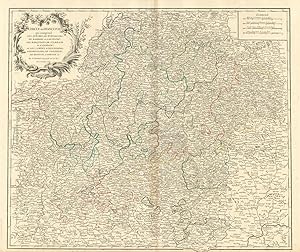
Condition: Good. "Carte des Cercles du Haut et du Bas Rhin". Germany Rhineland. VAUGONDY 1753 map. Large antique 18th century atlas map, printed on thick, good quality paper with original outline hand colour/color and decorative title cartouche; Robert de Vaugondy, Gilles & Didier (1753). 49.0 x 53.0cm, 19.25 x 20.75 inches; this is a folding map. Condition: Good. There is nothing printed on the reverse side, which is plain.
-
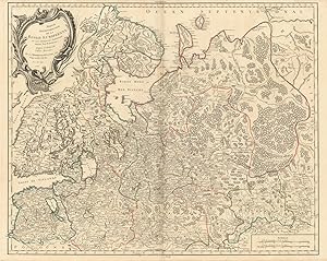
Partie Septentrionale de la Russie Europ�enne �u sont distingu�es exactement toutes les Provinces, d'apr�s le detail de l'Atlas Russien, Par le Sr. Robert de Vaugondy fils, Geog. ordin? du Roi. Avec Privil�ge
Publication Date: 1753
Map
Condition: Good. "Partie Septentrionale de la Russie Europ�enne" Finland Russia VAUGONDY 1753 map. Large antique 18th century atlas map, printed on thick, good quality paper with original outline hand colour/color and decorative title cartouche; Robert de Vaugondy, Gilles & Didier (1753). 49.5 x 62.5cm, 19.5 x 24.5 inches; this is a folding map. Condition: Good. Please contact us if you would like to arrange to view this map. There is nothing printed on the reverse side, which is plain.
-
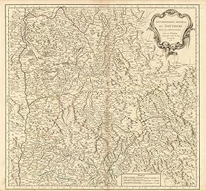
Gouvernement G�n�ral du Dauphin�, divis� par Bailliages, par le Sr. Robert, G�ographe ordin? du Roy. Avec Privilege
Publication Date: 1751
Map
Condition: Good. "Gouvernement G�n�ral du Dauphin�". Dr�me Is�re Hautes-Alpes. VAUGONDY 1751 map. Large antique 18th century atlas map, printed on thick, good quality paper with original outline hand colour/color and decorative title cartouche; Robert de Vaugondy, Gilles & Didier (1751). 50.0 x 54.0cm, 19.75 x 21.25 inches; this is a folding map. Condition: Good. There is nothing printed on the reverse side, which is plain.
-
Environs de Paris. Par le Sr. Robert Geographe ordinaire du Roi. Avec Privilege
Publication Date: 1753
Map
Condition: Good. "Environs de Paris" by ROBERT DE VAUGONDY 1753 old antique map plan chart. Large antique 18th century atlas map, printed on thick, good quality paper with original outline hand colour/color and decorative title cartouche; Robert de Vaugondy, Gilles & Didier (1753). 50.0 x 61.5cm, 19.75 x 24.25 inches; this is a folding map. Condition: Good. There is nothing printed on the reverse side, which is plain.
-
Gallia Antiqua in provincias et Populos divisa, Geographicis Sansonum conatibus et recentioribus Astronomicis observationibus accommodata ab Aeg. Robert Geographo regis ordinario cum Privilegio Regis
Publication Date: 1750
Map
Condition: Good. "Gallia Antiqua in provincias" Ancient Gaul. France. VAUGONDY 1750 old map. Large antique 18th century atlas map, printed on thick, good quality paper with original outline hand colour/color and decorative title cartouche; Robert de Vaugondy, Gilles & Didier (1750). 50.5 x 57.5cm, 19.75 x 22.5 inches; this is a folding map. Condition: Good. Light crease. There is nothing printed on the reverse side, which is plain.".
-
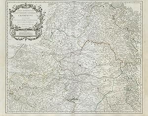
Partie Septentrionale du Gouvernem? General de Champagne o� se trouvent le Retelois, le Rhemois, la Champagne propre, Partie de la Brie et du Pertois, &c. Par le Sr. Robert G�og. Ord. du Roy. Avec Privilege
Publication Date: 1752
Map
Condition: Good. "Partie Septentrionale du Gouvernem. General de Champagne". VAUGONDY 1752 map. Large antique 18th century atlas map, printed on thick, good quality paper with original outline hand colour/color and decorative title cartouche; Robert de Vaugondy, Gilles & Didier (1752). 50.0 x 63.5cm, 19.75 x 25 inches; this is a folding map. Condition: Good. There is nothing printed on the reverse side, which is plain.
-
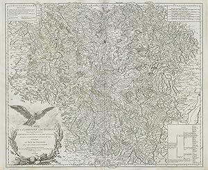
Condition: Good. "Carte de la Lorraine et du Barrois" Northeast France. VAUGONDY 1756 old map. Large antique 18th century atlas map, printed on thick, good quality paper with original outline hand colour/color and decorative title cartouche; Robert de Vaugondy, Gilles & Didier (1756). 49.5 x 61.0cm, 19.5 x 24 inches; this is a folding map. Condition: Good. There is nothing printed on the reverse side, which is plain.".