Order Total (1 Item Items):
Shipping Destination:

Royal Naval Intelligence Division (57 results)
Skip to main search results
Product Type
- All Product Types
- Books
- Magazines & Periodicals
- Comics
- Sheet Music
- Art, Prints & Posters (3)
- Photographs
- Maps (54)
-
Manuscripts &
Paper Collectibles
Condition
- All Conditions
- New
- Used
Binding
- All Bindings
- Hardcover
- Softcover
Collectible Attributes
- First Edition
- Signed
- Dust Jacket
- Seller-Supplied Images
- Not Printed On Demand
Seller Location
Seller Rating
-
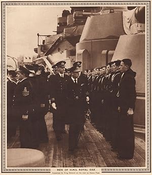
Condition: Good. KING EDWARD VIII. Inspecting men of H. M. S. Royal Oak 1937 old vintage print. Vintage book illustration; Royal Naval Intelligence Division (1937). 25.5 x 22.5cm, 10 x 8.75 inches. Condition: Good. There are images and/or text printed on the reverse side of the picture. In some cases this may be visible on the picture itself or around the margin of the picture.
-
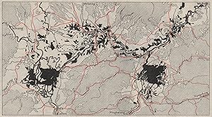
Condition: Good. NORTHERN ITALY. Landform types. WW2 ROYAL NAVY INTELLIGENCE MAP 1944 old. Vintage Second World War British Naval Intelligence map; British Naval Intelligence (1944). 18.0 x 32.5cm, 7 x 12.75 inches; this is a folding map. Condition: Good. There is nothing printed on the reverse side, which is plain.
-
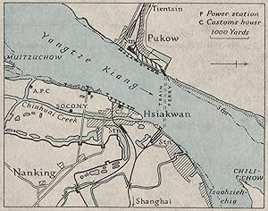
Condition: Fair. Nanking/NANJING Pukow/Pukou Hsiakwan. China. WW2 NAVY INTELLIGENCE MAP 1945. Vintage Second World War naval intelligence colour map; Royal Naval Intelligence Division (1945). 7.0 x 9.0cm, 2.75 x 3.5 inches. Condition: Fair: Verso text apparent. There are images and/or text printed on the reverse side of the picture. In some cases this may be visible on the picture itself or around the margin of the picture.
-
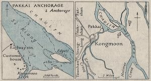
Condition: Fair. Kongmoon/JIANGMEN & Pakkai port. China. WW2 ROYAL NAVY INTELLIGENCE MAP 1945. Vintage Second World War naval intelligence colour map; Royal Naval Intelligence Division (1945). 4.5 x 9.0cm, 1.75 x 3.5 inches. Condition: Fair: Verso text apparent. There are images and/or text printed on the reverse side of the picture. In some cases this may be visible on the picture itself or around the margin of the picture.
-
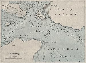
Condition: Fair. Approaches to Amoy (XIAMEN). China. WW2 ROYAL NAVY INTELLIGENCE MAP 1945. Vintage Second World War naval intelligence colour map; Royal Naval Intelligence Division (1945). 7.5 x 10.5cm, 3 x 4.25 inches. Condition: Fair: Verso text apparent. There are images and/or text printed on the reverse side of the picture. In some cases this may be visible on the picture itself or around the margin of the picture.
-
Condition: Fair. Yochow/YUEYANG. Chenglingji. China. WW2 ROYAL NAVY INTELLIGENCE MAP 1945. Vintage Second World War naval intelligence colour map; Royal Naval Intelligence Division (1945). 7.0 x 9.0cm, 2.75 x 3.5 inches. Condition: Fair: Verso text apparent. There are images and/or text printed on the reverse side of the picture. In some cases this may be visible on the picture itself or around the margin of the picture.
-
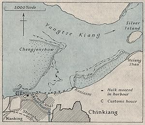
Condition: Fair. Chinkiang ZHENJIANG. China. WW2 ROYAL NAVY INTELLIGENCE MAP 1945 old. Vintage Second World War naval intelligence colour map; Royal Naval Intelligence Division (1945). 7.5 x 9.0cm, 3 x 3.5 inches. Condition: Fair: Verso text apparent. There are images and/or text printed on the reverse side of the picture. In some cases this may be visible on the picture itself or around the margin of the picture.
-
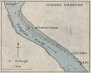
Condition: Fair. Ichang. YICHANG. China. WW2 ROYAL NAVY INTELLIGENCE MAP 1945 old vintage. Vintage Second World War naval intelligence colour map; Royal Naval Intelligence Division (1945). 7.0 x 9.0cm, 2.75 x 3.5 inches. Condition: Fair: Verso text apparent. There are images and/or text printed on the reverse side of the picture. In some cases this may be visible on the picture itself or around the margin of the picture.
-
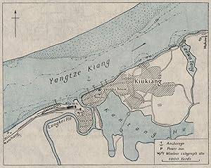
Condition: Fair. Kiukiang/JIUJIANG. China. WW2 ROYAL NAVY INTELLIGENCE MAP 1945 old vintage. Vintage Second World War naval intelligence colour map; Royal Naval Intelligence Division (1945). 8.5 x 10.5cm, 3.25 x 4.25 inches. Condition: Fair: Verso text apparent. There are images and/or text printed on the reverse side of the picture. In some cases this may be visible on the picture itself or around the margin of the picture.
-
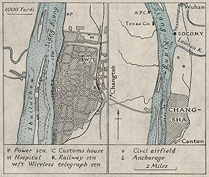
Condition: Fair. CHANGSHA. China. WW2 ROYAL NAVY INTELLIGENCE MAP 1945 old vintage chart. Vintage Second World War naval intelligence colour map; Royal Naval Intelligence Division (1945). 7.5 x 9.0cm, 3 x 3.5 inches. Condition: Fair: Verso text apparent. There are images and/or text printed on the reverse side of the picture. In some cases this may be visible on the picture itself or around the margin of the picture.
-
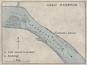
Condition: Fair. Shasi/Shashi/Jingzhou. China. WW2 ROYAL NAVY INTELLIGENCE MAP 1945 old. Vintage Second World War naval intelligence colour map; Royal Naval Intelligence Division (1945). 6.5 x 9.0cm, 2.5 x 3.5 inches. Condition: Fair: Verso text apparent. There are images and/or text printed on the reverse side of the picture. In some cases this may be visible on the picture itself or around the margin of the picture.
-
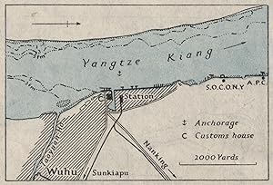
Condition: Fair. WUHU. China. WW2 ROYAL NAVY INTELLIGENCE MAP 1945 old vintage plan chart. Vintage Second World War naval intelligence colour map; Royal Naval Intelligence Division (1945). 6.0 x 9.0cm, 2.25 x 3.5 inches. Condition: Fair: Verso text apparent. There are images and/or text printed on the reverse side of the picture. In some cases this may be visible on the picture itself or around the margin of the picture.
-
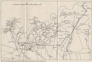
Condition: Good. ITALY. Electricity supply. Po Basin & Alps. WW2 ROYAL NAVY INTELLIGENCE MAP 1945. Vintage Second World War British Naval Intelligence map; British Naval Intelligence (1945). 18.5 x 27.0cm, 7.25 x 10.75 inches; this is a folding map. Condition: Good. There is nothing printed on the reverse side, which is plain.
-
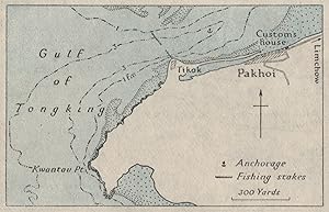
Condition: Fair. Pakhoi/BEIHAI. China. WW2 ROYAL NAVY INTELLIGENCE MAP 1945 old vintage. Vintage Second World War naval intelligence colour map; Royal Naval Intelligence Division (1945). 5.5 x 9.0cm, 2.25 x 3.5 inches. Condition: Fair: Verso text apparent. There are images and/or text printed on the reverse side of the picture. In some cases this may be visible on the picture itself or around the margin of the picture.
-
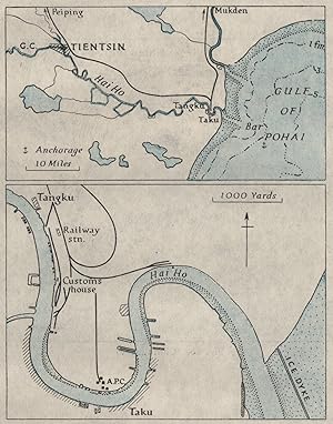
Condition: Fair. TIANJIN. Taku Tangku/Tanggu Hai Ho/Hai He. China. WW2 INTELLIGENCE MAP 1945. Vintage Second World War naval intelligence colour map; Royal Naval Intelligence Division (1945). 11.5 x 9.0cm, 4.5 x 3.5 inches. Condition: Fair: Verso text apparent. There are images and/or text printed on the reverse side of the picture. In some cases this may be visible on the picture itself or around the margin of the picture.
-
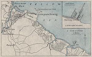
Condition: Fair. Lienyunchiang Laoyao Lianyungang China. WW2 ROYAL NAVY INTELLIGENCE MAP 1945. Vintage Second World War naval intelligence colour map; Royal Naval Intelligence Division (1945). 6.5 x 10.5cm, 2.5 x 4 inches. Condition: Fair: Verso text apparent. There are images and/or text printed on the reverse side of the picture. In some cases this may be visible on the picture itself or around the margin of the picture.
-
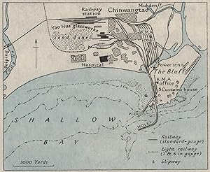
Condition: Fair. Chinwangtao/Qinhuangdao. China. WW2 ROYAL NAVY INTELLIGENCE MAP 1945 old. Vintage Second World War naval intelligence colour map; Royal Naval Intelligence Division (1945). 8.5 x 10.5cm, 3.25 x 4 inches. Condition: Fair: Verso text apparent. There are images and/or text printed on the reverse side of the picture. In some cases this may be visible on the picture itself or around the margin of the picture.
-
Condition: Good. AFRICA. physical and geology. Geology 1943 old vintage map plan chart. Vintage map; Royal Naval Intelligence Division (1943). 18.0 x 28.5cm, 7 x 11 inches; this is a folding map. Condition: Good. There is nothing printed on the reverse side, which is plain.
-
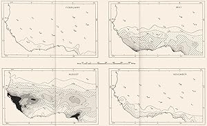
Condition: Good. TOGO. Togo. Rainfall 1944 old vintage map plan chart. Vintage map; Royal Naval Intelligence Division (1944). 17.0 x 28.5cm, 6.75 x 11.25 inches; this is a folding map. Condition: Good. There is nothing printed on the reverse side, which is plain.
-
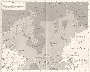
Condition: Good. NIGER. physical and geology. The Upper Niger Basin 1943 old vintage map chart. Vintage map; Royal Naval Intelligence Division (1943). 18.0 x 29.5cm, 7 x 11.75 inches; this is a folding map. Condition: Good. There is nothing printed on the reverse side, which is plain.
-
Condition: Good. NIGER. physical and geology. Niger 1943 old vintage map plan chart. Vintage map; Royal Naval Intelligence Division (1943). 18.0 x 22.5cm, 7 x 8.75 inches; this is a folding map. Condition: Good. There is nothing printed on the reverse side, which is plain.
-
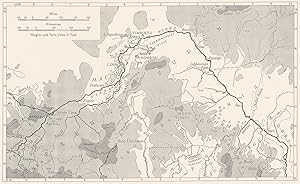
Condition: Good. MALI. physical and geology. Northern French Sudan 1943 old vintage map chart. Vintage map; Royal Naval Intelligence Division (1943). 18.0 x 23.5cm, 7 x 9.25 inches; this is a folding map. Condition: Good. There is nothing printed on the reverse side, which is plain.
-
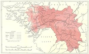
Condition: Good. GUINEA. French Guinea 1944 old vintage map plan chart. Colour vintage map; Royal Naval Intelligence Division (1944). 18.0 x 30.0cm, 7.25 x 11.75 inches; this is a folding map. Condition: Good. There is nothing printed on the reverse side, which is plain.
-
Condition: Good. TOGO. Togo. Isobars and Winds of the Federation 1944 old vintage map chart. Vintage map; Royal Naval Intelligence Division (1944). 18.0 x 25.0cm, 7 x 9.75 inches; this is a folding map. Condition: Good. There is nothing printed on the reverse side, which is plain.
-
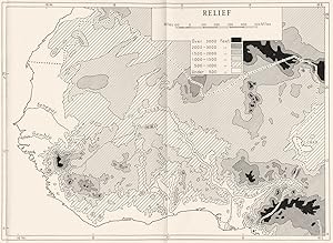
Condition: Good. AFRICA. Relief 1943 old vintage map plan chart. Vintage map; Royal Naval Intelligence Division (1943). 18.0 x 24.5cm, 7 x 9.5 inches; this is a folding map. Condition: Good. There is nothing printed on the reverse side, which is plain.
-
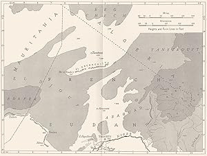
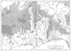
Condition: Good. GUINEA. physical and geology. The Guinea Coast Basins 1943 old vintage map. Vintage map; Royal Naval Intelligence Division (1943). 18.0 x 25.0cm, 7 x 9.75 inches; this is a folding map. Condition: Good. There is nothing printed on the reverse side, which is plain.
-
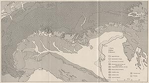
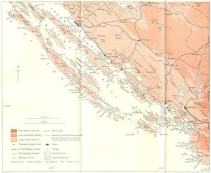
Fig 62. The coasts of the Primorje-Zagora Region and of the adjacent Islands
Publication Date: 1944
Map
Condition: Good. PRIMORJE. Coasts of-Zagora Region & Islands 1944 old vintage map plan chart. Colour vintage map; Royal Naval Intelligence Division (1944). 17.0 x 21.0cm, 6.75 x 8.25 inches; this is a folding map. Condition: Good. There is nothing printed on the reverse side, which is plain.
-
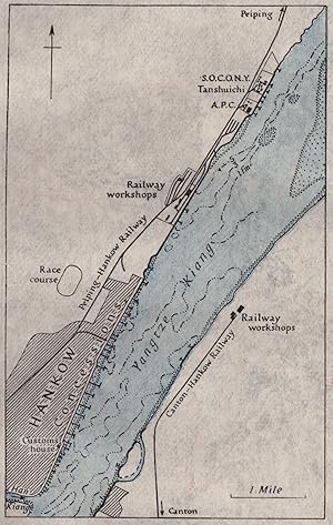
Condition: Good. YANGTZE RIVER, Wuhu to Yichang. China. WW2 ROYAL NAVY INTELLIGENCE MAP 1945. Vintage Second World War naval intelligence colour map; Royal Naval Intelligence Division (1945). 10.5 x 19.5cm, 4.25 x 7.5 inches. Condition: Good. There are images and/or text printed on the reverse side of the picture. In some cases this may be visible on the picture itself or around the margin of the picture.
-
Condition: Fair. Hankow/HANKOU. China. WW2 ROYAL NAVY INTELLIGENCE MAP 1945 old vintage. Vintage Second World War naval intelligence colour map; Royal Naval Intelligence Division (1945). 12.0 x 7.5cm, 4.75 x 3 inches. Condition: Fair: Verso text apparent. There are images and/or text printed on the reverse side of the picture. In some cases this may be visible on the picture itself or around the margin of the picture.
-
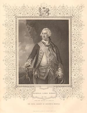
Condition: Good. BRITISH HISTORY. Admiral Lord Hawke. Seven Years' War. TALLIS 1849 old print. Antique steel engraved print with decorative border; Engraved by H. Robinson, from original of Kneller in the Hall of Christchurch, Oxford (1849). 23.0 x 17.5cm, 9 x 6.75 inches. Condition: Good. The image shown may have been taken from a different example of this print than that which is offered for sale. The print you will receive is in good condition but there may be minor variations in the condition from that shown in the image. There is nothing printed on the reverse side, which is plain.