Order Total (1 Item Items):
Shipping Destination:

Russell Findlay (987 results)
Skip to main search results
Product Type
- All Product Types
- Books (75)
- Magazines & Periodicals
- Comics
- Sheet Music
- Art, Prints & Posters
- Photographs
- Maps (912)
-
Manuscripts &
Paper Collectibles
Condition
Binding
Collectible Attributes
- First Edition (5)
- Signed
- Dust Jacket (2)
- Seller-Supplied Images (927)
- Not Printed On Demand
Free Shipping
Seller Location
Seller Rating
-

Fitted Up : A True Story of Police Betrayal, Conspiracy and Cover Up
Published by Birlinn, Limited, 2019
ISBN 10: 1780275390ISBN 13: 9781780275390
Book
Condition: Very Good. Used book that is in excellent condition. May show signs of wear or have minor defects.
More buying choices from other sellers on AbeBooks
New offers from US$ 12.61
Used offers from US$ 6.96
Also find Softcover
-

Acid Attack: A Journalist's War With Organised Crime
Published by Birlinn, 2018
ISBN 10: 1780274998ISBN 13: 9781780274997
Book
Paperback. Condition: Good. The book has been read but remains in clean condition. All pages are intact and the cover is intact. Some minor wear to the spine.
More buying choices from other sellers on AbeBooks
Used offers from US$ 2.31
-
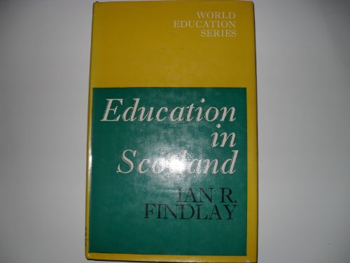
Education in Scotland
Published by David & Charles Publishers, 1973
ISBN 10: 0208013091ISBN 13: 9780208013095
Book
Condition: Good. Former library book; may include library markings. Used book that is in clean, average condition without any missing pages.
-

The Iceman: The Rise and Fall of a Crime Lord
Published by Birlinn, 2010
ISBN 10: 1841588717ISBN 13: 9781841588711
Book
Paperback. Condition: Very Good. The book has been read, but is in excellent condition. Pages are intact and not marred by notes or highlighting. The spine remains undamaged.
More buying choices from other sellers on AbeBooks
Used offers from US$ 5.15
-
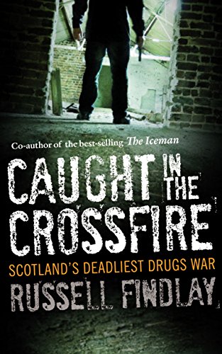
Caught in the Crossfire: Scotland's Deadliest Drugs War
Published by Birlinn, 2012
ISBN 10: 1841589918ISBN 13: 9781841589916
Book
Paperback. Condition: Very Good. The book has been read, but is in excellent condition. Pages are intact and not marred by notes or highlighting. The spine remains undamaged.
More buying choices from other sellers on AbeBooks
Used offers from US$ 6.44
-

VENOMOUS ANIMALS AND THEIR TOXINS
Published by Smithsonian Inst Annual Rept, 1964, Wash, DC, 1965
First Edition
Pamphlet. Condition: Very Good. 1st Edition. Ann Rept for 1964, pp. 477-487+ 2 Photo Plts, Extracted from orig vol, begins with title page, trimmed & stapled, thus is like a pamphlet, VG.
-
Hardcover. Condition: Good. Cover and edges shows minor shelf wear. Edges shows minor foxing. Few pages shows light foxing. Pages shows minor tanning.
-
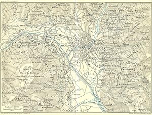
Condition: Good. MERANO & ENVIRONS. Vintage map plan. Italy 1927 old vintage chart. Coloured vintage map; Muirhead, James, Findlay & Russell (Blue guides) (1927). 15.0 x 20.0cm, 5.75 x 7.75 inches; this is a folding map. Condition: Good. Tight right margin; The image shown may have been taken from a different example of this map than that which is offered for sale. The map you will receive is in good condition but there may be minor variations in the condition from that shown in the image. There is nothing printed on the reverse side, which is plain.
-
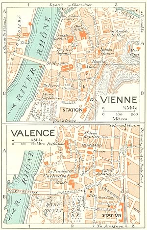
Condition: Good. FRANCE. Vienne; Valence 1926 old vintage map plan chart. Coloured vintage map; Muirhead, James, Findlay & Russell (Blue guides) (1926). 14.0 x 8.5cm, 5.5 x 3.5 inches. Condition: Good. The image shown may have been taken from a different example of this map than that which is offered for sale. The map you will receive is in good condition but there may be minor variations in the condition from that shown in the image. There is nothing printed on the reverse side, which is plain.
-
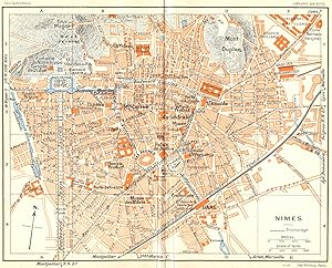
Condition: Good. PROVENCE. Nimes 1926 old vintage map plan chart. Coloured vintage map; Muirhead, James, Findlay & Russell (Blue guides) (1926). 15.0 x 18.5cm, 5.75 x 7.25 inches; this is a folding map. Condition: Good. The image shown may have been taken from a different example of this map than that which is offered for sale. The map you will receive is in good condition but there may be minor variations in the condition from that shown in the image. There is nothing printed on the reverse side, which is plain.
-
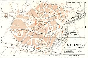
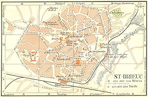
Condition: Good. BRITTANY. Bretagne. St Brieuc 1928 old vintage map plan chart. Coloured vintage map; Drawn by L. Hermann, Delt (1928). 8.5 x 13.0cm, 3.25 x 5 inches. Condition: Good. The image shown may have been taken from a different example of this map than that which is offered for sale. The map you will receive is in good condition but there may be minor variations in the condition from that shown in the image. There is nothing printed on the reverse side, which is plain.
-
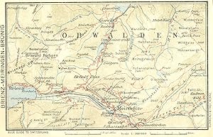
Condition: Good. SWITZERLAND. Brienz-Meiringen-Brunig 1923 old antique vintage map plan chart. Coloured vintage map; Muirhead, James, Findlay & Russell (Blue guides) (1923). 9.0 x 14.5cm, 3.5 x 5.75 inches. Condition: Good. The image shown may have been taken from a different example of this map than that which is offered for sale. The map you will receive is in good condition but there may be minor variations in the condition from that shown in the image. There is nothing printed on the reverse side, which is plain.
-
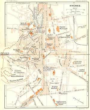
Condition: Good. FRANCE. Hyeres 1926 old vintage map plan chart. Coloured vintage map; Muirhead, James, Findlay & Russell (Blue guides) (1926). 18.0 x 14.5cm, 7 x 5.75 inches; this is a folding map. Condition: Good. Minor offsetting -text and/or images from the facing page have left an impression on the print; The image shown may have been taken from a different example of this map than that which is offered for sale. The map you will receive is in good condition but there may be minor variations in the condition from that shown in the image. There is nothing printed on the reverse side, which is plain.
-
Condition: Good. BRITTANY. St Brieuc 1932 old vintage map plan chart. Coloured vintage map; Muirhead, James, Findlay & Russell (Blue guides) (1932). 9.0 x 13.5cm, 3.5 x 5.25 inches. Condition: Good. The image shown may have been taken from a different example of this map than that which is offered for sale. The map you will receive is in good condition but there may be minor variations in the condition from that shown in the image. There is nothing printed on the reverse side, which is plain.
-
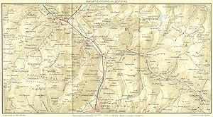
Condition: Good. SWITZERLAND. Ragatz-Coire-Klosters 1923 old antique vintage map plan chart. Coloured vintage map; Muirhead, James, Findlay & Russell (Blue guides) (1923). 14.5 x 26.5cm, 5.75 x 10.5 inches; this is a folding map. Condition: Good. The image shown may have been taken from a different example of this map than that which is offered for sale. The map you will receive is in good condition but there may be minor variations in the condition from that shown in the image. There is nothing printed on the reverse side, which is plain.
-
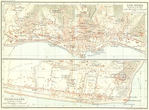
Condition: Good. SAN REMO & BORDIGHERA. Vintage town city map plans. Italy 1927 old vintage. Coloured vintage map; Muirhead, James, Findlay & Russell (Blue guides) (1927). 14.5 x 20.0cm, 5.75 x 7.75 inches; this is a folding map. Condition: Good. The image shown may have been taken from a different example of this map than that which is offered for sale. The map you will receive is in good condition but there may be minor variations in the condition from that shown in the image. There are images and/or text printed on the reverse side of the picture. In some cases this may be visible on the picture itself or around the margin of the picture.
-
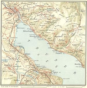
Condition: Good. SWITZERLAND. Environs of Thun 1923 old antique vintage map plan chart. Coloured vintage map; Muirhead, James, Findlay & Russell (Blue guides) (1923). 14.5 x 14.0cm, 5.5 x 5.5 inches; this is a folding map. Condition: Good. The image shown may have been taken from a different example of this map than that which is offered for sale. The map you will receive is in good condition but there may be minor variations in the condition from that shown in the image. There is nothing printed on the reverse side, which is plain.
-
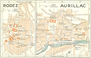
Condition: Good. FRANCE. Rodez; Aurillac 1926 old vintage map plan chart. Coloured vintage map; Muirhead, James, Findlay & Russell (Blue guides) (1926). 8.5 x 14.0cm, 3.5 x 5.5 inches. Condition: Good. The image shown may have been taken from a different example of this map than that which is offered for sale. The map you will receive is in good condition but there may be minor variations in the condition from that shown in the image. There is nothing printed on the reverse side, which is plain.
-
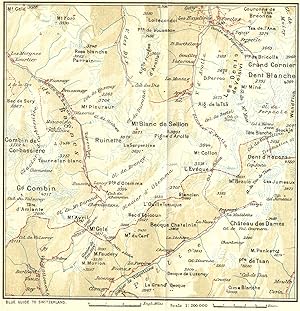
Condition: Good. SWITZERLAND. Fionnay-Arolla 1923 old antique vintage map plan chart. Coloured vintage map; Muirhead, James, Findlay & Russell (Blue guides) (1923). 14.5 x 14.0cm, 5.75 x 5.5 inches; this is a folding map. Condition: Good. Tight top margin; The image shown may have been taken from a different example of this map than that which is offered for sale. The map you will receive is in good condition but there may be minor variations in the condition from that shown in the image. There is nothing printed on the reverse side, which is plain.
-
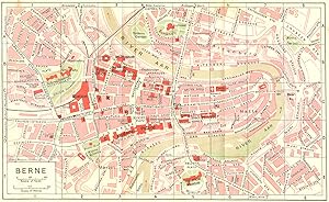
Condition: Good. SWITZERLAND. Berne 1923 old antique vintage map plan chart. Coloured vintage map; Muirhead, James, Findlay & Russell (Blue guides) (1923). 13.5 x 22.5cm, 5.25 x 8.75 inches; this is a folding map. Condition: Good. The image shown may have been taken from a different example of this map than that which is offered for sale. The map you will receive is in good condition but there may be minor variations in the condition from that shown in the image. There is nothing printed on the reverse side, which is plain.
-
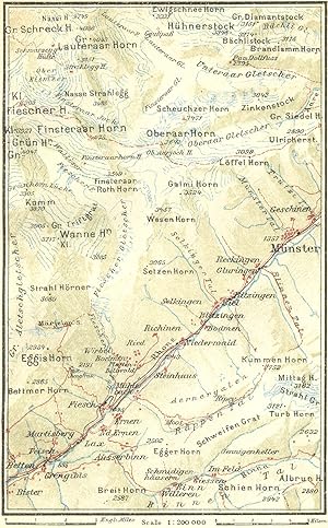
Condition: Good. SWITZERLAND. Eggishorn-Munster 1923 old antique vintage map plan chart. Coloured vintage map; Muirhead, James, Findlay & Russell (Blue guides) (1923). 14.0 x 8.5cm, 5.5 x 3.5 inches. Condition: Good. The image shown may have been taken from a different example of this map than that which is offered for sale. The map you will receive is in good condition but there may be minor variations in the condition from that shown in the image. There is nothing printed on the reverse side, which is plain.
-
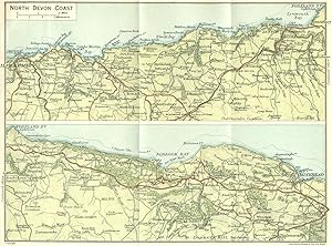
Condition: Good. DEVON. North Coast 1924 old vintage map plan chart. Colour vintage map; John Bartholomew & Son (1924). 14.5 x 20.0cm, 5.75 x 7.75 inches; this is a folding map. Condition: Good. The image shown may have been taken from a different example of this map than that which is offered for sale. The map you will receive is in good condition but there may be minor variations in the condition from that shown in the image. There is nothing printed on the reverse side, which is plain.
-
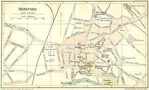
Condition: Good. HEREFORD. Town Plan 1924 old vintage map chart. Colour vintage map; John Bartholomew & Son (1924). 8.5 x 14.5cm, 3.5 x 5.75 inches. Condition: Good. The image shown may have been taken from a different example of this map than that which is offered for sale. The map you will receive is in good condition but there may be minor variations in the condition from that shown in the image. There is nothing printed on the reverse side, which is plain.
-
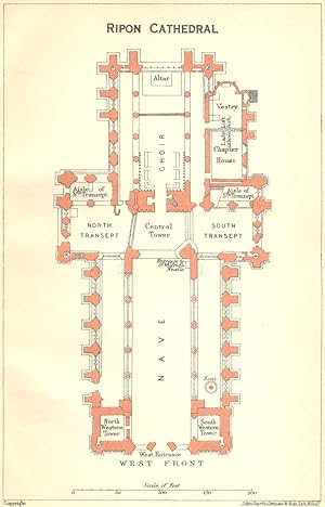
Condition: Good. YORKS. Ripon cathedral 1924 old vintage map plan chart. Colour vintage map; John Bartholomew & Son (1924). 14.5 x 9.0cm, 5.5 x 3.5 inches. Condition: Good. The image shown may have been taken from a different example of this map than that which is offered for sale. The map you will receive is in good condition but there may be minor variations in the condition from that shown in the image. There is nothing printed on the reverse side, which is plain.
-
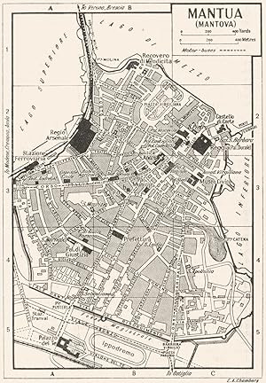
Condition: Good. MANTUA town/city plan. Italy 1953 old vintage map chart. Vintage map; E.A. Chambers (1953). 13.0 x 9.0cm, 5 x 3.5 inches. Condition: Good. Verso text quite apparent; The image shown may have been taken from a different example of this map than that which is offered for sale. The map you will receive is in good condition but there may be minor variations in the condition from that shown in the image. There are images and/or text printed on the reverse side of the picture. In some cases this may be visible on the picture itself or around the margin of the picture.
-
Condition: Good. PARMA town/city plan. Italy 1953 old vintage map chart. Vintage map; E.A. Chambers (1953). 9.0 x 13.0cm, 3.5 x 5 inches. Condition: Good. Verso text quite apparent; The image shown may have been taken from a different example of this map than that which is offered for sale. The map you will receive is in good condition but there may be minor variations in the condition from that shown in the image. There are images and/or text printed on the reverse side of the picture. In some cases this may be visible on the picture itself or around the margin of the picture.
-
Condition: Good. NORTHANTS. Peterborough cathedral 1924 old vintage map plan chart. Colour vintage map; John Bartholomew & Son (1924). 14.5 x 9.5cm, 5.75 x 3.75 inches. Condition: Good. The image shown may have been taken from a different example of this map than that which is offered for sale. The map you will receive is in good condition but there may be minor variations in the condition from that shown in the image. There is nothing printed on the reverse side, which is plain.
-
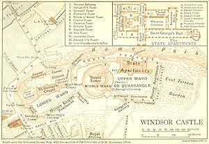
Condition: Good. BERKS. Windsor Castle 1924 old vintage map plan chart. Colour vintage map; Emery Walker Ltd Sc (1924). 9.5 x 14.0cm, 3.75 x 5.5 inches. Condition: Good. The image shown may have been taken from a different example of this map than that which is offered for sale. The map you will receive is in good condition but there may be minor variations in the condition from that shown in the image. There is nothing printed on the reverse side, which is plain.
-
Condition: Good. CREMONA town/city plan. Italy 1953 old vintage map chart. Vintage map; E.A. Chambers (1953). 9.0 x 12.5cm, 3.5 x 5 inches. Condition: Good. Verso text quite apparent; The image shown may have been taken from a different example of this map than that which is offered for sale. The map you will receive is in good condition but there may be minor variations in the condition from that shown in the image. There are images and/or text printed on the reverse side of the picture. In some cases this may be visible on the picture itself or around the margin of the picture.
-
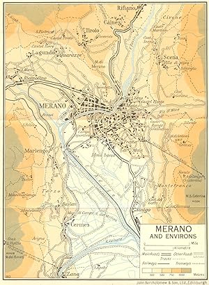
Condition: Good. Merano and Environs 1953 old vintage map plan chart. Colour vintage map; John Bartholomew & Son (1953). 19.0 x 14.0cm, 7.5 x 5.5 inches; this is a folding map. Condition: Good. The image shown may have been taken from a different example of this map than that which is offered for sale. The map you will receive is in good condition but there may be minor variations in the condition from that shown in the image. There is nothing printed on the reverse side, which is plain.