Order Total (1 Item Items):
Shipping Destination:

Texaco Touring Service Texas Company (2 results)
Skip to main search results
Product Type
- All Product Types
- Books (2)
- Magazines & Periodicals
- Comics
- Sheet Music
- Art, Prints & Posters
- Photographs
- Maps
-
Manuscripts &
Paper Collectibles
Condition
- All Conditions
- New
- Used
Binding
- All Bindings
- Hardcover
- Softcover (1)
Collectible Attributes
- First Edition
- Signed
- Dust Jacket
- Seller-Supplied Images (1)
- Not Printed On Demand
Seller Location
Seller Rating
-

TEXACO TOURING MAP: DELAWARE, MARYLAND and WEST VIRGINIA
(1938 - code T3807). 21x28" sheet folding to 7x3". Color map of Delaware, Maryland, West Virginia with 6 city inserts & index; other side has Texaco Sectional Trip Map (T3849), Gasoline Taxes March 15, 1938, cover art, Mileage Chart, &c. Lightly rubbed, soiled, G.
-
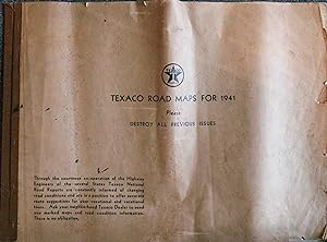
Texaco Road Maps for 1941
Published by n.p., n.p., 1941
Seller: High Ridge Books, Inc. - ABAA, South Deerfield, MA, U.S.A.
Association Member: ABAA ESA ILAB SNEAB
Seller Rating:

Atlas of bound road maps. Priginal printed brown paper wrappers, light chipping and small tears at edges. Maps are all very good to excellent. 45 maps, all printed on rectos only. Printed by Rand McNally. The maps are versions of items which would have been available at gas stations, but were never folded. Only two of the maps have the mostly text panels which would have been on the outside of the folded versions, while all of the other maps have only the map portions. All of the maps include inset maps of cities and their vicinities. List of maps inside front cover. This is a very scarce and unusual format for a series of maps always seen as distinct pieces. All maps are part of the Texaco Touring Map series. OCLC 956398660 ( 1 loc., Library of Congress).