
Order Total (1 Item Items):
Shipping Destination:

Verdun Crenne J R (1 results)
Feedback
Skip to main search results
Search filters
Product Type
- All Product Types
- Books (No further results match this refinement)
- Magazines & Periodicals (No further results match this refinement)
- Comics (No further results match this refinement)
- Sheet Music (No further results match this refinement)
- Art, Prints & Posters (No further results match this refinement)
- Photographs (No further results match this refinement)
- Maps (1)
- Manuscripts & Paper Collectibles (No further results match this refinement)
Condition
- All Conditions
- New (No further results match this refinement)
- Used (1)
Binding
- All Bindings
- Hardcover (No further results match this refinement)
- Softcover (No further results match this refinement)
Collectible Attributes
- First Edition (No further results match this refinement)
- Signed (No further results match this refinement)
- Dust Jacket (No further results match this refinement)
- Seller-Supplied Images (1)
- Not Print on Demand (1)
Free Shipping
- Free Shipping to U.S.A. (No further results match this refinement)
Seller Rating
-
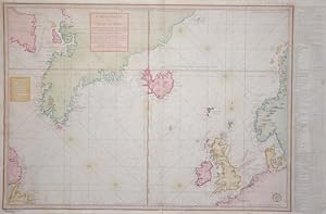
Carte reduite des Mers du Nord
Published by Artist: Verdun de la Crenne JR
Seller: Antique Sommer& Sapunaru KG, M�nchen, Germany
Seller rating 4 out of 5 stars

Map
Condition: UNSPECIFIED. Technic: Copper print, colorit: colored, condition: Left and right lower corners replaced, size (in cm): 56,5 x 87; - Map shows the northern Atlantic with the european North Sea, Greenland, Island, Graet Britain and partly Norway and Canada; History: For a long time in human history, the Atlantic was the great water that separated the "Old World" from the "New World". With an area of __about 106 million square kilometers, the Atlantic covers about a fifth of the earth's surface. The extent of the Atlantic Ocean is enormous, which is why a distinction is made between the North and South Atlantic. In the west it touches the two American continents and in the east Europe and Africa hold it back. After the first crossing of Christopher Columbus (1492), there were regular ocean crossings only in the 19th century. The people in Europe wanted to leave the poor conditions of that time behind and start over in the burgeoning America. There were real waves of emigration. Is Columbus the Discoverer of America? This view is controversial. The Vikings, who are said to have stranded on the coasts of Canada around the year 1000 after an odyssey across the Atlantic, keep coming up. Columbus may have known about it and could see their maps. The Chinese navigator Zheng He is often named as the discoverer of America. At the beginning of 2006, a Chinese collector found a map from 1413, on which America, Asia and Europe are already drawn. But whether this card is real and thus the Chinese are the true discoverers of the "New World", nobody really knows. The first transatlantic steamer set sail from Bremerhaven on July 2, 1847. His destination was the port of New York. The people took extreme hardship on such crossings, because the overcrowded decks were anything but comfortable.