Order Total (1 Item Items):
Shipping Destination:

Wytfliet Cornelius (26 results)
Skip to main search results
Product Type
- All Product Types
- Books (26)
- Magazines & Periodicals
- Comics
- Sheet Music
- Art, Prints & Posters
- Photographs
- Maps
-
Manuscripts &
Paper Collectibles
Condition
- All Conditions
- New
- Used
Binding
Collectible Attributes
- First Edition (17)
- Signed
- Dust Jacket (2)
- Seller-Supplied Images (5)
- Not Printed On Demand
Free Shipping
Seller Location
Seller Rating
-

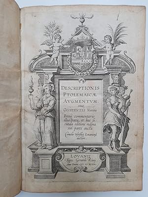
Descriptionis Ptolemaicae Augmentum Sive Occidentis Notitia Brevis Commentario Louvain 1597
Published by N. Israel-Meridian
Seller: Wonder Book, Frederick, MD, U.S.A.
Seller Rating:

Condition: Fair. Amsterdam: N. Israel/Meridian, 1964. Facsimile. 4to. xii,104pp. Latin. Maps. Book Good. No dust jacket. Minor edgewear. (cartography, atlases, America) Inquire if you need further information.
-
DESCRIPTIONIS PTOLEMAICAE AUGMENTUM SIVE OCCIDENTIS NOTITIA BREVIS COMMENTARIO - Louvain 1597
Published by N. Israel - Meridian Pub. Co, Amsterdam, 1964
Book
Hardcover. Condition: Very Good. Dust Jacket Condition: Good. Exact facsimile of 1597 original.1st atlas just on America. Introduction of 12 pages by the great scholar, R A Skelton (some neat ruler underlining). Dust jacket present with 3" tear repaired.104pp.
-
Castilia Avrifera cum Vicinis Provinciis
Published by A Douay: Aux despens de Fran�ois Fabri, 1605., 1605
First Edition
Single sheet (10 6/8 x 13 inches; 9 x 11 inches to the neat line). Fine engraved map of parts of Colombia, Venezuela and Panama, the title within an elaborate strapwork and allegorical cartouche upper left (one or two marginal spots). From the first French edition of Wytfliet's "Descriptionis Ptolemaicae augmentum", "Histoire Vniverselle des Indes". A Douay: Aux despens de Fran�ois Fabri, 1605. Castilla de Oro, named by Ferdinand II of Aragon after his own realm of Castile in Spain, and the rich seams of gold that the Spanish found there. Cornelis van Wytfliet, secretary to the Council of Brabant, called his atlas of the New World a supplement to Ptolemy's "Geography", although the two works are actually quite separate. Dedicated to King Philip III of Spain, and covering the history of the first European encounters with the New World, its geography, and natural history. Wyfliet used as his source the works of Acosta, Hakluyt, de Bry and Ramusio. JCB, Archive of Early American Images B07-111-000. Kohl 261. Van der Krogt (editor), Koeman's Atlantes Neerlandici 371:11:7 (illustrated 9810:371, Variant B, with corrected "Timana"). Winsor, Narrative and Critical History of America. Dorothy Sloan, Sale 23, April 4th, 2013, lot 15.
-
Residvvm Continentis Cvm Adiacentibvs Insvlis
Published by A Douay: Aux despens de Fran�ois Fabri, 1605., 1605
First Edition
Single sheet (10 6/8 x 13 inches; 9 x 11 inches to the neat line). Fine engraved map of the northern coast of South America including Venezuela and the Lesser Antilles, the title within a fine mannerist strapwork cartouche upper right (a little toned). From the first French edition of Wytfliet's "Descriptionis Ptolemaicae augmentum", "Histoire Vniverselle des Indes". A Douay: Aux despens de Fran�ois Fabri, 1605. Cornelis van Wytfliet, secretary to the Council of Brabant, called his atlas of the New World a supplement to Ptolemy's "Geography", although the two works are actually quite separate. Dedicated to King Philip III of Spain, and covering the history of the first European encounters with the New World, its geography, and natural history. Wyfliet used as his source the works of Acosta, Hakluyt, de Bry and Ramusio. Phillips, America, p. 1052. Van der Krogt (editor), Koeman's Atlantes Neerlandici 371:11:8 (illustrated 9700:371, present copy Variant B, with correction to "Tacari"). Dorothy Sloan, Sale 23, April 4th, 2013, lot 15.
-
Chili Provincia Amplissima
Published by A Douay: Aux despens de Fran�ois Fabri, 1605., 1605
First Edition
Single sheet (10 5/8 x 13 inches; 9 x 11 inches to the neat line). Fine engraved map of Chile from Camana to Valdivia, the title within a fine mannerist strapwork cartouche lower left (a bit toned). Variant B with "Plat� Pars" at top right, from the first French edition of Wytfliet's . "Descriptionis Ptolemaicae augmentum", "Histoire Vniverselle des Indes". A Douay: Aux despens de Fran�ois Fabri, 1605. Showing the coast of Chile from Camana to Valdivia and the Rio de Palominos or present-day Rio Calle-Calle, with many towns located along the coast and upriver, and the Andes mountains. JCB, Archive of Early American Images B07-112-000. Phillips, America, p. 233. Van der Krogt (editor), Koeman's Atlantes Neerlandici 371:11:3 (illustrated 9920:371). Dorothy Sloan, Sale 23, April 4th, 2013, lot 15.
-
Pervani Regni Descriptio. 1597.
Published by A Douay: Aux despens de Fran�ois Fabri, 1605., 1605
First Edition
Single sheet (10 6/8 x 13 inches; 9 x 11 inches to the neat line). Fine engraved map of Peru, with parts of Bolivia, Ecuador, and Brazil, the title within a fine mannerist strapwork cartouche lower left. From the first French edition of Wytfliet's "Descriptionis Ptolemaicae augmentum", "Histoire Vniverselle des Indes". A Douay: Aux despens de Fran�ois Fabri, 1605. Both the coastline and the interior of Peru are depicted in some detail, including Inca and Spanish cities, the Andes, all rich in silver mines. Cornelis van Wytfliet, secretary to the Council of Brabant, called his atlas of the New World a supplement to Ptolemy's "Geography", although the two works are actually quite separate. Dedicated to King Philip III of Spain, and covering the history of the first European encounters with the New World, its geography, and natural history. Wyfliet used as his source the works of Acosta, Hakluyt, de Bry and Ramusio. Phillips, America, p. 692. Van der Krogt (editor), Koeman's Atlantes Neerlandici 371:11:6 (illustrated 9820:371:1). Dorothy Sloan, Sale 23, April 4th, 2013, lot 15.
-
Ivcatana Regio Et Fondvra
Published by A Douay: Aux despens de Fran�ois Fabri, 1605., 1605
First Edition
Single sheet (10 6/8 x 13 inches; 9 x 11 inches to the neat line). Fine engraved map of the Yucat�n peninsula and southeastern Mexico to northern Panama, including Honduras, Costa Rica, and Nicaragua, the title within a fine mannerist strapwork cartouche upper right. "The only sixteenth-century map to focus solely on Central America. This map is a good example of the image of Central America that was being formed in the European mind" (Antochiw). From the first French edition of Wytfliet's "Descriptionis Ptolemaicae augmentum", "Histoire Vniverselle des Indes". A Douay: Aux despens de Fran�ois Fabri, 1605. Cornelis van Wytfliet, secretary to the Council of Brabant, called his atlas of the New World a supplement to Ptolemy's "Geography", although the two works are actually quite separate. Dedicated to King Philip III of Spain, and covering the history of the first European encounters with the New World, its geography, and natural history. Wyfliet used as his source the works of Acosta, Hakluyt, de Bry and Ramusio. Antochiw, Historia cartogr�fica de la Pen�nsula de Yucat�n, Plate 4 in portfolio. Bornholt, Cuatro Siglos de Expresiones Geogr�ficas del Istmo Centroamericano 26 (p. 64), noting that the 1597 state of the map Phillips, America, p. 214. Van der Krogt (editor), Koeman's Atlantes Neerlandici 371:11:11 (illustrated 9550:371). Dorothy Sloan, Sale 23, April 4th, 2013, lot 15.
-
Single sheet (10 6/8 x 13 inches; 9 x 11 inches to the neat line). Fine engraved map of the coast of Brasil north of the Tropic of Capricorn to the Equator, the title within a fine mannerist strapwork cartouche lower left. From the first French edition of Wytfliet's "Descriptionis Ptolemaicae augmentum", "Histoire Vniverselle des Indes". A Douay: Aux despens de Fran�ois Fabri, 1605. Cornelis van Wytfliet, secretary to the Council of Brabant, called his atlas of the New World a supplement to Ptolemy's "Geography", although the two works are actually quite separate. Dedicated to King Philip III of Spain, and covering the history of the first European encounters with the New World, its geography, and natural history. Wyfliet used as his source the works of Acosta, Hakluyt, de Bry and Ramusio. Phillips, America, p. 170. Van der Krogt (editor), Koeman's Atlantes Neerlandici 371:11:5 (illustrated 9850:371, Variant B). Dorothy Sloan, Sale 23, April 4th, 2013, lot 15.
-
Single sheet (10 6/8 x 13 inches; 9 x 11 inches to the neat line). Fine engraved map of the Island of Hispaniola, or Haiti and Dominican Republic, and the eastern coast of Cuba, the title within a fine mannerist strapwork cartouche upper right (a bit toned). From the first French edition of Wytfliet's "Descriptionis Ptolemaicae augmentum", "Histoire Vniverselle des Indes". A Douay: Aux despens de Fran�ois Fabri, 1605. On exactly which island in the Caribbean Columbus first made landfall is a still a matter of debate, however of his voyage he left "a vivid but often fantastic and romanticized record, substantial fragments of which have survived. He described Cuba and Hispaniola as well as some smaller islands and recorded conflicting perceptions of the inhabitants, seeing them at times as semibestial savages, at others as models of sylvan innocence or dependence on God; at times as potential slaves to be exploited, at others as souls to be saved. Those of Hispaniola (Arawak Tainos) he was inclined to praise as remarkable civilized beings bearing implicit promise of great civilizations near at hand. Treating as providential the grounding of his flagship on the north coast of Hispaniola [at Nativitat, - ed] on Christmas Day 1492, he left thirty-nine men behind on terms of apparent amity with the locals" (Felipe Fern�ndez-Armesto for ANB). Wytfliet's map is quite detailed and shows both Spanish and indigenous settlements, but . "after 1540 there was a long period of stagnation in the representation of Santo Domingo. It did appear as a single map, Hispaniola Insula, in.Wytfliet in 1597, but this map represents a regression on the early versions" (p. 315 in B.W. Higman's "The Cartography of the Caribbean, 1500-1560" in Vol. II, General History of the Caribbean: New Societies, The Caribbean in the Long Sixteenth Century, UNESCO, 1999). Cornelis van Wytfliet, secretary to the Council of Brabant, called his atlas of the New World a supplement to Ptolemy's "Geography", although the two works are actually quite separate. Dedicated to King Philip III of Spain, and covering the history of the first European encounters with the New World, its geography, and natural history. Wyfliet used as his source the works of Acosta, Hakluyt, de Bry and Ramusio. Van der Krogt (editor), Koeman's Atlantes Neerlandici 371:11:9 (illustrated 9630:371, noting variant B with correction to "Punt. de Nigua," etc., as in present copy). Dorothy Sloan, Sale 23, April 4th, 2013, lot 15.
-
Estotilandia Et Laboratoris Terra
Published by A Douay: Aux despens de Fran�ois Fabri, 1605., 1605
First Edition
Single sheet (10 6/8 x 13 inches; 9 x 11 inches to the neat line). Fine engraved map centered on the Davis Strait, showing Greenland, the extreme northeast of Canada, Iceland, and the mythical island of Frisland, the title within a fine strapwork and allegorical cartouche upper left (pale marginal stains, one or two spots). From the first French edition of Wytfliet's "Descriptionis Ptolemaicae augmentum", "Histoire Vniverselle des Indes". A Douay: Aux despens de Fran�ois Fabri, 1605. Including the mythical map of Frisland which appeared on virtually all of the maps of the North Atlantic from the 1560s through the 1660s, until French and English navigators explored the area. "The map's importance comes from its concentration on the area of the English voyages of Frobisher and Davis; they are depicted here in greater detail than before. Clearly derived from Cornelis Claes Nova Francia of 1594, Wytfliet interestingly draws upon the inset on it for the area of Labrador which had offered an alternative representation to the main map. Some information is shown twice on this map as both Frobisher and Davis visited the same shores but were unaware of the fact" (Burden 101). Kohl 113. Phillips, America, p. 303. Trudel, Atlas de la Nouvelle France, p. 65. Van der Krogt (editor), Koeman's Atlantes Neerlandici 371:11:19 (illustrated 9110:371). Dorothy Sloan, Sale 23, April 4th, 2013, lot 15.
-
Plata Americae Provincia
Published by A Douay: Aux despens de Fran�ois Fabri, 1605., 1605
First Edition
Single sheet (10 5/8 x 13 inches; 9 x 11 2/8 inches to the neat line). Fine engraved map showing the Rio de la Plata and its system of tributaries, Uruguay, and interior parts of southern Brazil, Chile, and Peru, the title within a fine mannerist strapwork cartouche lower left. Title within cartouche at lower left (a little toned). From the first French edition of Wytfliet's . "Descriptionis Ptolemaicae augmentum", "Histoire Vniverselle des Indes". A Douay: Aux despens de Fran�ois Fabri, 1605. This is the foundation map of the Rio de la Plata region. Importantly it shows Assumption, where Cabeza de Vaca, helped establish government for the remaining colonists of Buenos Aires in 1541. Van der Krogt (editor), Koeman's Atlantes Neerlandici 371:11:4 (illustrated 9910:371). Dorothy Sloan, Sale 23, April 4th, 2013, lot 15.
-
Cvba Insvla Et Iamaica
Published by A Douay: Aux despens de Fran�ois Fabri, 1605., 1605
First Edition
Single sheet (10 6/8 x 13 inches; 9 x 11 inches to the neat line). Fine engraved map of Cuba and Jamaica, the Cayman Islands, and western Hispaniola, the title within an elaborate strapwork and allegorical cartouche (a little toned). From the first French edition of Wytfliet's "Descriptionis Ptolemaicae augmentum", "Histoire Vniverselle des Indes". A Douay: Aux despens de Fran�ois Fabri, 1605. On exactly which island in the Caribbean Columbus first made landfall is a still a matter of debate, however of his voyage he left "a vivid but often fantastic and romanticized record, substantial fragments of which have survived. He described Cuba and Hispaniola as well as some smaller islands and recorded conflicting perceptions of the inhabitants, seeing them at times as semibestial savages, at others as models of sylvan innocence or dependence on God; at times as potential slaves to be exploited, at others as souls to be saved" (Felipe Fern�ndez-Armesto for ANB). Cuba "had been settled for thousands of years by Arawak-speaking tribes, and was densely populated in its eastern half when first seen by Europeans during the first voyage of Columbus, who reported the Taino name as "Colba." This dynamic map shows many place names on the coast as well as the interior, and mountains are delineated in hachure" (Dorothy Sloan, Sale 23, April 4th, 2013, lot 15). Cueto, Cuba in Old Maps 16. Kapp, Printed Maps of Jamaica up to 1825 #5. Phillips, America, p. 253. Van der Krogt (editor), Koeman's Atlantes Neerlandici 371:11:10 (illustrated 9610:271).
-
Utriusque Hemispherii Delineatio
Published by A Douay: Aux despens de Fran�ois Fabri, 1605., 1605
First Edition
Single sheet (10 5/8 x 13 2/8 inches; 8 7/8 x 11 inches to the neat line). A fine engraved double-hemisphere world map, title within a fine mannerist strapwork cartouche top center, stipple-engraved seas, beneath the two hemispheres Atlas holds up the two parts of the world (some marginal spotting) A fine double-hemisphere world map from the first French edition of Wytfliet's . "Descriptionis Ptolemaicae augmentum", "Histoire Vniverselle des Indes". A Douay: Aux despens de Fran�ois Fabri, 1605. Reduced from Rumold Mercator's map of 1587, which in turn was condensed from his father Gerard Mercator's great world map of 1569, and Chile retains its distinctive bulge from that map. Curiously enough on this map the longitude of California is only about 40�. Wytfliet apparently had to shorten this in order to get America on the hemisphere. No names are shown on the coast, only to the north: El Streto de Anian and Anian Regnum" (Wagner). Cornelis van Wytfliet, secretary to the Council of Brabant, called his atlas of the New World a supplement to Ptolemy's "Geography", although the two works are actually quite separate. Dedicated to King Philip III of Spain, and covering the history of the first European encounters with the New World, its geography, and natural history. Wyfliet used as his source the works of Acosta, Hakluyt, de Bry and Ramusio. Shirley 207 (and 157); Wagner, "Cartography of the Northwest Coast" ( #191 p. 293). Dorothy Sloan, Sale 23, April 4th, 2013, lot 15.
-
Chica Sive Patagonica Et Avstralis Terra. 1597
Published by A Douay: Aux despens de Fran�ois Fabri, 1605., 1605
First Edition
Single sheet (10 6/8 x 13 2/8 inches; 9 x 11 2/8 inches to the neat line). Engraved map in two parts showing the coast of Patagonia and the Strait of Magellan, and part of a southern hemisphere showing Antarctica, with the title in a fine oval mannerist strapwork cartouched lower right, decorated with a fine three-masted galleon sailing through the Strait of Magellan (browned, one of two stains affecting the image). An early state of this map, dated 1597, from the first French edition of Wytfliet's . "Descriptionis Ptolemaicae augmentum", "Histoire Vniverselle des Indes". A Douay: Aux despens de Fran�ois Fabri, 1605. Interestingly in the map of Antarctica, New Guinea is shown as being separate from Terra Australis, implying that Wytfliet knew of the Torres strait some eight years before Luis Vaez de Torres approached it from the east. The accompanying text corroborates his supposed knowledge: "The Australis Terra is the most southern of all lands. It is separated from New Guinea by a narrow strait. Its shores are hitherto but little known, since, after one voyage and another, that route has been deserted, and seldom is the country visited, unless sailors are driven there by storms. The Australis Terra begins at two or three degrees from the Equator, and is maintained by some to be of so great an extent that, if it were thoroughly explored, it would be regarded as a fifth part of the world". JCB, Archive of Early American Images B07-110-000. Schilder, Australia Unveiled, pp. 18-19. Tooley, The Mapping of Australia and Antarctica #1439. Van der Krogt (editor), Koeman's Atlantes Neerlandici 371:11:2 (illustrated 9950:371.1, with date). Dorothy Sloan, Sale 23, April 4th, 2013, lot 15.
-
Nova Francia Et Canada. 1597.
Published by A Douay: Aux despens de Fran�ois Fabri, 1605., 1605
First Edition
Single sheet (10 6/8 x 13 inches; 9 x 11 inches to the neat line). Fine engraved map of Northeast Canada, the title within a fine mannerist strapwork cartouche mid-right (a little toned). Burden s first state. From the first French edition of Wytfliet s "Descriptionis Ptolemaicae augmentum", "Histoire Vniverselle des Indes". A Douay: Aux despens de Fran�ois Fabri, 1605. "The last of the eight maps relating to North America in Wytfliet s first atlas of the New World. It is the first to use CANADA in its title, and the first to concentrate on the river and Gulf of St. Lawrence. It summarises sixteenth-century knowledge of the area just prior to the expansion of France here, and voyages of Samuel de Champlain. The general outline is derived largely from Gerard Mercator, with additional information gleaned from other sources" (Burden 103). Kershaw, Early Printed Maps of Canada, pp. 40-43 & Plate 22. Kohl 164. Phillips, America, p. 189. Van der Krogt (editor), Koeman s Atlantes Neerlandici 371:11:18 (illustrated 9160:371.1). Dorothy Sloan, Sale 23, April 4th, 2013, lot 15.
-
Limes Occidentis Quiuira et Anian. 1597
Published by A Douay: Aux despens de Fran�ois Fabri, 1605., 1605
First Edition
Single sheet (10 6/8 x 13 inches; 9 x 11 inches to the neat line). Fine engraved map of the west coast of North America, the title within a plain cartouche lower left, decorated with a large and detailed compass rose (pale marginal staining). From the first French edition of Wytfliet's "Descriptionis Ptolemaicae augmentum", "Histoire Vniverselle des Indes". A Douay: Aux despens de Fran�ois Fabri, 1605. Showing the "entire coastal portions of the present day United States and Canada. The general shape derives from that of Mercator's world map of 1569, with a pronounced bulge coincidentally similar to that of Alaska as we know it today, but latitudinally larger so that its south coast is at about 40 degrees. all of the coast above approximately C.Medocino was yet to be visited by Europeans and it was left to Captain James Cook, 180 years later, to first accurately chart these waters. South of this the Spanish had made a number of exploratory voyages starting in the 1530s" (Burden 107). Kohl 282. Lowery 85n. Phillips, America, p. 558. Van der Krogt (editor), Koeman's Atlantes Neerlandici 371:11:14 (illustrated 9190.371.1). Wagner, Cartography of the Northwest Coast #189 (p. 292). Dorothy Sloan, Sale 23, April 4th, 2013, lot 15.
-
Single sheet (10 6/8 x 13 inches; 9 x 11 inches to the neat line). Fine engraved map of Mexico from the far northwestern region to the southeastern area, including the western coast of the Gulf of Mexico, Acapulco, Culiacan, Guadalajara, Veracruz, and Mexico City, the title within an elaborate strapwork and allegorical cartouche lower left (some small patches of surface abrasion, one or two spots). From the first French edition of Wytfliet's "Descriptionis Ptolemaicae augmentum", "Histoire Vniverselle des Indes". A Douay: Aux despens de Fran�ois Fabri, 1605. "This map concentrated on the Spanish area of influence in present day Mexico. Like a lot of his maps [Wytfliet] draws from Plancius' world map of 1592 amongst others. The area covered takes in all of present day southern Texas up to the latitude of 30� north" (Burden 108). Cornelis van Wytfliet, secretary to the Council of Brabant, called his atlas of the New World a supplement to Ptolemy's "Geography", although the two works are actually quite separate. Dedicated to King Philip III of Spain, and covering the history of the first European encounters with the New World, its geography, and natural history. Wyfliet used as his source the works of Acosta, Hakluyt, de Bry and Ramusio. Burden, The Mapping of North America 105 (notes only one state, but van der Krogt notes variant B with "Xalis" changed to "Xalisco" etc; our copy is variant B): Kohl 263. Phillips, America, p. 404. Reinhartz & Saxon, The Mapping of the Entradas into the Greater Southwest, p. 203 and illustrated as Plate 6.56. Van der Krogt (editor), Koeman's Atlantes Neerlandici 371:11:12 (illustrated 9510:371). Wagner, Cartography of the Northwest Coast #190 (p. 293). Dorothy Sloan, Sale 23, April 4th, 2013, lot 15.
-
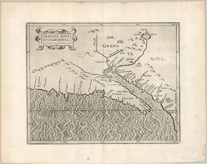
Granata Nova et California. The first printed map dedicated to California and the American Southwest.
Published by c. 1603, 1603
Seller: Curtis Wright Maps, Berwyn, IL, U.S.A.
Seller Rating:

Condition: Fine. "This is an excellent example of the "only sixteenth-century printed map specifically devoted to southern California" (Schwarz & Ehrenberg), originally issued in the "first separately printed atlas related exclusively to the Americas" (Tooley). Granata Nova et California was first published in Louvain in 1597 as part of Cornelius Wyfliet's Descriptionis Ptolemaicae Augmentum and is primarily based on a world map by Petrus Plancius from five years prior. This is a later issue, likely printed around 1607, though the map is known in only one state. The image reflects Spanish explorations from the mid to late 16th century, including Coronado's epic journey across Mexico and the American Southwest from 1540-1542. He was in charge of a large expedition to look for the legendary Seven Cities of Gold, which can be seen in the upper right surrounding a large lake. Though Coronado and his companions ultimately found only villages made of adobe, wood, or animal skins, the names associated with the myth - Cibola and Quivira - would persist on maps well into the 17th century. Not all toponyms are fables, however, and compared to later maps, some of which would show California as an island, the geography is surprisingly accurate. A foundational map in the cartography of California and the American Southwest. Sources; Burden #106, Wagner #187, Schwart & Ehrenberg Plate 41, Tooley's Dictionary of Mapmakers." Sheet Width (in) 15.1 Sheet Height (in) 11.9 Condition Description Light creasing along the vertical centerfold and a bit of faint scattered soiling confined to the margins. Two small spots of toning on the verso from where previously matted, but it does not affect the image. Near fine overall.
-
Granata Nova et California
Published by A Douay: Aux despens de Fran�ois Fabri, 1605., 1605
First Edition
Single sheet (10 6/8 x 13 inches; 9 x 11 inches to the neat line). Fine engraved map of the Gulf of California, Mexican coast, and west coast of California, which is shown as a peninsula, oriented to the east, the title within fine mannerist strapwork cartouche top left. "The first printed map devoted to California and the south-west of the present day United States. One of the most interesting features is the depiction of so many fabled places largely from Spanish sources. Most notable amongst these are the seven cities of Cibola. The seven cities originated from the narrative of Fray Marcos de Niza in 1539. Some of the other nomenclature originates from Coronado's epic exploration. The outline map is fairly accurate and is derived largely from Petrus Plancius' large world map of 1592. The main coastal irregularity is the westward slant of the Californian coastline. Bearing in mind that it would be shown as part of an island in twenty five years, this is quite forgivable. No other states of the map are known and all issues are without text on the back" (Burden 106). From the first French edition of Wytfliet's "Descriptionis Ptolemaicae augmentum", "Histoire Vniverselle des Indes". A Douay: Aux despens de Fran�ois Fabri, 1605. Cornelis van Wytfliet, secretary to the Council of Brabant, called his atlas of the New World a supplement to Ptolemy's "Geography", although the two works are actually quite separate. Dedicated to King Philip III of Spain, and covering the history of the first European encounters with the New World, its geography, and natural history. Wyfliet used as his source the works of Acosta, Hakluyt, de Bry and Ramusio. JCB, Early American Images 0854-2. Burden, The Mapping of North America 106 (only one state, but Van der Krogt notes variant B corrected to "Per latan" like our copy): California 49: Forty-Nine Maps of California from the Sixteenth Century to the Present, Map 7 (p. 14 & 15, illustrated). Dorothy Sloan, Sale 23, April 4th, 2013, lot 15; Kohl 282. Lowery 99. Nebenzahl, "Mapping the Transmississippi West" #9 (p. 8 & illustrated as Figure 4 on p. 9). Phillips, America, p. 404.Schwartz & Ehrenberg, The Mapping of America Plate 41: "Only sixteenth-century printed map specifically devoted to Southern California." Van der Krogt (editor), Koeman's Atlantes Neerlandici 371:11:13 (illustrated 9530:371). Wagner, Cartography of the Northwest Coast #188 (p. 292). Wheat, Mapping the Transmississippi West 29 & Vol. I, p. 28.
-
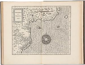
Norvmbega Et Virginia. 1597
Published by A Douay: Aux despens de Fran�ois Fabri, 1605., 1605
First Edition
Single sheet (10 6/8 x 13 inches; 9 x 11 inches to the neat line). Fine engraved map of the northeastern coast of North America from Virginia to Cape Breton in New France, the title within a plain cartouche upper left, decorated with a large detailed compass rose to the lower right (one or two marginal spots). Burden's first state with the left latitudinal mark reads 30 instead of 39. From the first French edition of Wytfliet's "Descriptionis Ptolemaicae augmentum", "Histoire Vniverselle des Indes". A Douay: Aux despens de Fran�ois Fabri, 1605. Showing the eastern seaboard of North America from Cape Breton south to the Outer Banks of North Carolinas, described by Burden as "the most accurate map of the east coast until de Laet", this makes an interesting comparison with the Smith map of New England, with its contraction of the New England, New Jersey and Virginia region. The great city of "Norumbega" prominent to the right of the title, an early New England misconception, is generally thought to represent the Penobscot region in Maine. Thus this map omits completely Cape Cod, New York, Long Island and New Jersey, with the next "recognisable" feature to the south being "Chesipooc Bay", although not the Chesapeake Bay as we know it today, or as mapped by Smith in 1608. Cornelis van Wytfliet, secretary to the Council of Brabant, called his atlas of the New World a supplement to Ptolemy's "Geography", although the two works are actually quite separate. Dedicated to King Philip III of Spain, and covering the history of the first European encounters with the New World, its geography, and natural history. Wyfliet used as his source the works of Acosta, Hakluyt, de Bry and Ramusio. Burden 103; JCB, Early American Images 0854-1. Cumming, The Southeast in Early Maps 19. Danforth, The Land of Norumbega: Maine in the Age of Exploration and Settlement 49. McCorkle, New England in Early Printed Maps 597.3 (illustrated, p. 14). Phillips, America, p. 558. Phillips, Virginia Cartography, pp. 18-19. Schwartz & Ehrenberg, The Mapping of America, Plate 40 (p. 80). Stokes, Iconography of Manhattan Island, 1915-28, II, Plate 20. Van der Krogt (editor), Koeman's Atlantes Neerlandici 371:11:17 (illustrated 9200:371.1 & 2). Dorothy Sloan, Sale 23, April 4th, 2013, lot 15.
-
Hispania Nova (Mexico)
Published by Louvain, 1597
Seller: Arader Galleries of Philadelphia, PA, Philadelphia, PA, U.S.A.
Seller Rating:
Book
N/A. Condition: Very Good. Dust Jacket Condition: N/A. Engraving with original hand-color. Sheet size: 11 1/2 x 14 1/2". Inventory#: p1400pmat.
-
Histoire universelle des Indes, orientales et occidentales.
Published by Douai: Fran�ois Fabri, 1607, 1607
Three parts in one volume, folio (12 x 7 1/2 in.; 30.5 x 19.1 cm). Three engraved titles (the first supplied in facsimile), 19 total engraved double-page maps including a double hemisphere world map after Rumold Mercator (Shirley 207) and 18 maps of the Americas, text within double rules, woodcut initials, head- and tailpieces. BINDING/CONDITION: Later stiff vellum; boards bowed. Lacking two leaves: general title (supplied in facsimile) and blank leaf S4 in Part I, light to moderate intermittent browning, marginal stain on f6 and K4v in Part III dust-soiled. (64V1G) The second edition in French. The first part is extracted and freely translated from the first edition published in Latin (1597). The important series of American maps are printed from the same copper plates, with only very minor changes, primarily to the titles. This edition of the atlas is augmented with an account of the East Indies by Italian astronomer, cartographer and mathematician, Giovanni Antonio Magini (1555-1617). The third part, also by Magini, is a relation of the Jesuit missions and their attempts to convert the indigenous peoples there to Christianity. Wytfliet's atlas had been an immediate success, and over the next two decades six more editions, including three with French text (as here) were published. PROVENANCE: Jean R. Perrette (bookplate and his sale, Christie's New York, 5 April 2016, lot 34) REFERENCES: Alden/European Americana 607/100; Borba de Moraes II, p. 381; JCB (1919) II, p. 48; Phillips, Atlases 1143; Sabin 105700. Note: Sabin does not call for the 4 half-page maps of Japan, India, China and the Philippines present in the 1605 edition, although they are given in Borba de Moraes and JCB. They are not present in this copy.
-
Descriptionis Ptolemaicae augmentum sive occidentis notitia. Brevi commentario illustrata, et hac secunda editione magna sui parte aucta.
Published by Printed in Louvain: Gerard Rivius, 1598
Book
Soft cover. Condition: Very Good. 2nd Edition. Engraved title-page and 19 double-page engraved maps: a double-hemisphere world map and 18 regional maps of the Americas. With a beautiful contemporary vellum binding. A very nice copy of the second edition of the FIRST ATLAS OF AMERICA. Small folio (11.6 x 7.9 inches). Cornelis Wytfliet, secretary to the Council of Brabant, called his atlas of the New World a supplement to Ptolemy's GEOGRAPHY. The book is dedicated to King Philip III of Spain, and is covering the history of the first European encounters with the New World, its geography, and natural history. Wyfliet used as his source the works of Acosta, Hakluyt, de Bry and Ramusio. Wytfliet s "Descriptionis" was the first separately published atlas with all the maps entirely devoted to America. Koeman, Wyt 2; Philips 3645; Sabin 105697.
-
Descriptionis Ptolemaicae augmentum sive occidentis notitia. Brevi commentario illustrata, et hac secunda editione magna sui parte aucta.
Published by Louvain: Gerard Rivius, 1598, 1598
Folio (12 x 7 1/2 in.; 30.5 x 19.1 cm). Engraved architectural title-page surmounted by the Habsburg imperial coat of arms, dedication to Philip III (fol. ***2), notice to the reader (fol. ***3), epigram (fol. ***4r), privileges dated 15 May 1598 and 17 July 1597 (fol. ***4v), table of maps (fol. Aa4v), 19 copper-engraved double page maps interleaved in the text, woodcut initials and head- and tailpieces, one pagination error (Aa1 reads "158" instead of "185"). BINDING/CONDITION: Contemporary limp vellum, yapp edges, modern green silk ties, contemporary titling on spine. Linen folding case, black morocco lettering piece on spine. Light to moderate browning throughout, text offsetting to verso of map of Florida. (64V1G) A GOOD, UNSOPHISTICATED COPY of the second edition, Rivius issue (shared with Johann Bogaerts), of the earliest American atlas. "Chica sive Patagonica," "Peruani regni descriptio," "Limes Occidentis," "Norumbega et Virginia," and "Nova Francia et Canada" all bear the date of 1597. Wytfliet's atlas, firsts published in 1597, was an immediate success, and six further editions, including three with French text, were published within the next two decades. In this edition all pagination errors but one have been corrected and the errata eliminated.PROVENANCE: Antonis Orsetti, Luca (near contemporary inscription on recto of front free endpaper partially obscuring another, together with a manuscript location guide to the maps) REFERENCES: Borba de Moraes 2:381; Alden/European Americana 598/122; Gallup, "Wytfliet's Descriptionis Ptolemaicae Augmentum" in the Papers of the Bibliographical Society of America, 76:1 (1982), pp. 66-67; Koeman III, Wyt 2; Phillips, Atlases 3645; Sabin 105697; cf. Burden, The Mapping of North America 100-107 and Shirley, World 207.
-
Descriptionis Ptolemaicae augmentum sive occidentis notitia. Brevi commentario illustrata, et hac secunda editione magna sui parte aucta.
Published by Louvain: Gerard Rivius, 1598, 1598
Folio (12 x 7 3/4 in.; 30.5 x 19.7 cm). Engraved architectural title-page surmounted by the Habsburg imperial coat of arms, dedication to Philip III (fol. ***2), notice to the reader (fol. ***3), epigram (fol. ***4r), privileges dated 15 May 1598 and 17 July 1597 (fol. ***4v), table of maps (fol. Aa4v), 19 copper-engraved double page maps interleaved between the preliminaries and the text, woodcut initials and head- and tailpieces, one pagination error (Aa1 reads "158" instead of "185"). BINDING/CONDITION: Contemporary German pigskin over boards roll-tooled in blind stamped with central lozenge on front cover and ecclesiastical arms of a bishop on the lower cover, plain endpapers and edges, traces of two pairs of ties, short crack to joint at foot of spine, extremities rubbed. Ownership inscriptions on title-page partially eradicated, some browning to text, occasional small faint dampstains on lower margins and inside corners of upper margins. (64V1G) AN OUTSTANDING, UNSOPHISTICATED COPY of the second edition, Rivius issue (shared with Johann Bogaerts), of the earliest American atlas, with good, strong impressions of the maps: "Chica sive Patagonica," "Peruani regni descriptio," "Limes Occidentis," "Norumbega et Virginia," and "Nova Francia et Canada" all bear the date of 1597. Wytfliet's atlas, firsts published in 1597 was an immediate success, and six further editions, including three with French text, were published within the next two decades. In this edition all pagination errors but one have been corrected and the errata eliminated. PROVENANCE: B[ibliotheca] Maria[e] in Salem, Convent of the Cistercians of Salem, north of Lake Constance, Germany (contemporary inscription on top margin of title-page); Bibliotheca Minoraugiensis, Premonstratensian Convent of Weissenau in Swabia, near Ravensburg, viz. north of Lake Constance (inscription on lower margin of title-page); Voyages and Travels from the Library of David Parsons (sale, Sotheby's New York, 11 December 2007, lot 96) Arader Galleries gratefully acknowledges the assistance of Dr. Paul S. Needham, Scheide Librarian at Princeton, for determining the details of the early ownership inscriptions REFERENCES: Borba de Moraes 2:381; Alden/European Americana 598/122; Gallup, "Wytfliet's Descriptionis Ptolemaicae Augmentum" in the Papers of the Bibliographical Society of America, 76:1 (1982), pp. 66-67; Koeman III: Wyt 2; Phillips, Atlases 3645; Sabin 105697; cf. Burden, The Mapping of North America 100-107 and Shirley, World 207.
-
DESCRIPTIONIS PTOLEMAICAE AUGMENTUM, SIVE OCCIDENTALIS NOTITIA BREVI COMMENTARIO ILLUSTRATA.
Published by Louvain: Johann Bogaerts, 1597, 1597
Book
Hardcover. Condition: Fine. "Small folio (11 3/4 x 7 1/2 in. 30 x 19.2 cm). Engraved title within an elaborate architectural frame surmounted by the Habsburg imperial coat of arms, privileges dated 15 May 1597 and 17 July 1596, 19 copper-engraved double page maps interleaved in text, text mispaginated as usual but complete with final blank. BINDING/CONDITION: Full brown morocco by Alix, the spine in six compartments with raised bands (the second and last lettered gilt), marbled endpapers, edges gilt. Quarter brown morocco folding case, two green morocco labels on spine, one on front of case; a few nicks. (64V1G) A FINE, BRIGHT COPY. THE RARE FIRST EDITION, FIRST ISSUE. A SUPERB COPY OF THE FIRST ATLAS SPECIFICALLY DEVOTED TO THE AMERICAS. "As the first general geography of America, the text of Wytfliet's work may, at least in some degree, have contributed to dispel many of the errors regarding the New World In the history of early cartography, the maps in Wytfliet's Augmentum play the same part for the New World as Ptolemy's do for the old hemisphere, and they give us.a valuable summary of the early cartography of America" (Nordenski�ld. Facsimile-Atlas to the History of Cartography). CONTAINING SOME OF THE EARLIEST REGIONAL MAPS OF NORTH AMERICA. Intended to supplement Ptolemy's Geographia, Wytfliet describes those parts of the world revealed by modern discovery that were unknown to the Alexandrian geographer. Wytfliet edited his text using printed editions of primary sources accounts of the early exploration period such as the works of Acosta, Hakluyt, de Bry and Ramusio. He supplements his text with a fine double-hemispherical world map based on Rumold Mercator's 1587 map (Shirley 207) and eighteen regional representations of the Americas: eight maps of North America (Burden 100-107), ten maps of South America (Chile, Peru, two maps of Brazil, present-day Colombia and Venezuela, the northernmost coast of South America with the neighboring Caribbean islands, Hispaniola, Cuba, and Jamaica, and two maps of Central America). Significant among the North American maps are New England and Virginia, New France and Canada, Florida and Apalche, New Granada and California, and Quivira and Anian. "Norvmbega et Virginia" is the most accurate depiction of the east coast from the Carolinas to Canada until Joannes de Laet's 1630 "Nova Anglia, Novvm Belgivm, et Virginia" and the second map to use the name Virginia. "Nova Francia et Canada" is the first to use "Canada" in its title and the first to focus on the river and the Gulf of St. Lawrence. It summarizes sixteenth-century knowledge of the region just prior to major French expansion there and the voyages of Samuel de Champlain (Burden 102). "Granata Nova et California" is the first printed map specifically devoted to California and the southwest of the present-day United States. One of its interesting features is its depiction of a number of fabled places, largely derived from Spanish sources. "Limes Occidentis | Quiuira et Anian" encompasses the western coastal portions of the present-day United States and Canada. Based on Gerard Mercator's world map (1569), its bulging shape is remarkably similar to that of Alaska as it is known today (Burden 107).".