Order Total (1 Item Items):
Shipping Destination:

9780723304852 - The Shell Guide to the Routeburn Track by Philip Temple (3 results)
Feedback
Skip to main search results
Search filters
Product Type
- All Product Types
- Books (3)
- Magazines & Periodicals (No further results match this refinement)
- Comics (No further results match this refinement)
- Sheet Music (No further results match this refinement)
- Art, Prints & Posters (No further results match this refinement)
- Photographs (No further results match this refinement)
- Maps (No further results match this refinement)
- Manuscripts & Paper Collectibles (No further results match this refinement)
Condition
- All Conditions
- New (No further results match this refinement)
- Used (3)
Binding
- All Bindings
- Hardcover (No further results match this refinement)
- Softcover (3)
Collectible Attributes
- First Edition (No further results match this refinement)
- Signed (No further results match this refinement)
- Dust Jacket (No further results match this refinement)
- Seller-Supplied Images (2)
- Not Print on Demand (3)
Free Shipping
- Free Shipping to U.S.A. (No further results match this refinement)
Seller Rating
-
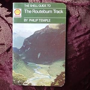
Shell Guide to the Routeburn Track
Published by Imprint unknown, 1976
ISBN 10: 0723304858 ISBN 13: 9780723304852
Seller: Creaking Shelves Books, Spean Bridge, United Kingdom
Association Member: PBFA
Seller rating 5 out of 5 stars

Original Illustrated Card Cove. Condition: Very Good. 2nd Edition. 40p illustrated.Map. An outline of this 39Km route on the South Island of New Zealand, north of Queenstown.In clean unmarked condition. See scans.
-

The Shell guide to the Routeburn track
Published by Whitcoulls, New Zealand, 1976
ISBN 10: 0723304858 ISBN 13: 9780723304852
Paperback. Condition: Good. slight rubbing to cover edges.
-
The Shell Guide to the Routeburn Track
Published by Whitcoulls Publishers, Christchurch, New Zealand, 1976
ISBN 10: 0723304858 ISBN 13: 9780723304852
Softcover (Saddle-stapled). Condition: Very Good. maps & photographs (illustrator). reprint. slight rubbing of the edges nearer the spine, probably from being slid into a pocket. No other damage internally, illustrated with single page and double page and part page photographs, giving a history of the track, and a route "guide", with a double page map. Size: 12mo (standard paperback). 40 pages. Text body is clean, and free from previous owner annotation, underlining and highlighting. Please refer to accompanying picture (s). Illustrator: maps & photographs. Quantity Available: 1. Shipped Weight: Under 500 grams. Category: Travel & Places; New Zealand; Geography & Maps. ISBN: 0723304858. ISBN/EAN: 9780723304852. Inventory No: 0256768.