
Order Total (1 Item Items):
Shipping Destination:

amsterdam nieuw amsterdam publishers (32 results)
Skip to main search results
Product Type
- All Product Types
- Books (25)
- Magazines & Periodicals
- Comics
- Sheet Music
- Art, Prints & Posters (4)
- Photographs
- Maps (3)
-
Manuscripts &
Paper Collectibles
Condition
- All Conditions
- New
- Used
Binding
Collectible Attributes
- First Edition
- Signed
- Dust Jacket (1)
- Seller-Supplied Images (29)
- Not Printed On Demand
Free Shipping
Seller Location
Seller Rating
-

R.v.R. Being an Account of the Last Years and the Death of One Rembrandt Harmenszoon Can Rijn
Published by Tudor Publishing Company, Nieuw Amsterdam, 1930
Hardcover. Condition: Very Good -. No Jacket. Normal scuffing, with spine fading; slightly shaken spine and inner hinge cracking. A biographical study on the last days and work of Rembrandt. 570 pages. Book.
-
Rembrandt Harmenszoon Van Rijn
Published by Tudor Publishing, Nieuw Amsterdam, 1936
Seller: Popeks Used and Rare Books, IOBA, Oneonta, NY, U.S.A.
Association Member: IOBA
Seller Rating:

Hard Cover. Condition: Good. No Jacket. Illustrated (illustrator). This is an account of the last years and death of artist Rembrandt Harmenszoon Van Rijn. Book is in good condition with tanned pages, some foxing, owner's name, faded spine, wear, and soil. 570 pages, 9.5 x 6.5.
-
De Venetiaanse meesters: 26 juli - 11 october 1953
Published by Rijksmuseum / Nieuw Amsterdam Publishers, 1953
Book
brossura. Condition: buone condizioni. Tentoonstellingscatalogus 1953. Afbeeldingen niet inbegrepen in de tekstpagina's, Ill. bn: 81 z/w illustraties, Ill. colori: --, Peso: 415 gr.
-
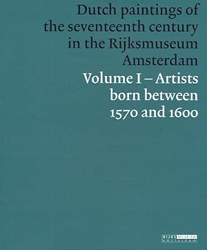
Dutch paintings of the seventeenth century in the Rijksmuseum Amsterdam : volume I ; artist born between 1570 and 1600.
Published by Amsterdam : Nieuw Amsterdam Publishers, 2007
ISBN 10: 908689027XISBN 13: 9789086890279
Book
Leinen. Zust.: Gutes Exemplar. Mit original Schutzumschlag. Mit zahlreichen Abbildungen, 583 Seiten Englisch 3180g.
-
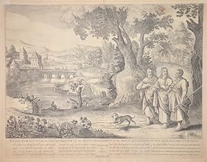
Et Factum est ut dum Coloquerentur, et se mutuo Rogitarent, ip se Jesus accederet, et una iter feceret cum ipsis
Published by Artist: Witde/ Schutt P Frederick ( - 1698 ) Amsterdam ; issued in: Amsterdam ; ca: 1730; - Frederik de Wit (1610 ? 1698) His Atlas began to appear around 1662 and by 1671 included anywhere from 17 to 151 maps each In the 1690s he began to use a new title page "Atlas Maior" but continued to use his old title page His atlas of the Low Countries first published in 1667was named Nieuw Kaertboeck van de XVII Nederlandse Provinci�n and contained 14 to 25 maps Frederik de Wit quickly expanded upon his first small folio atlas which contained mostly maps printed from plates that he had acquired to an atlas with 27 maps engraved by or for him By 1671 he was publishing a large folio atlas with as many as 100 maps Smaller atlases of 17 or 27 or 51 map, 1610
Seller: Antique Sommer& Sapunaru KG, M�nchen, Germany
Seller Rating:

Art / Print / Poster
Technic: Copper print; colorit: black/white; condition: Very good, size (in cm): 40 x 51,5; - Biblical scene of the New Testament, Luc. Capt. 24, Ph.13, with beautiful and decorative view and staffage; - Special feature: From Historiae Sacrae, New Testament.
-
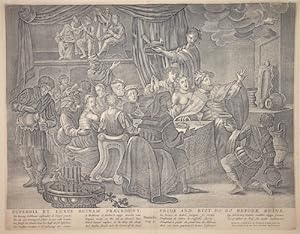
Superbia et Luxus Ruinam Praecedunt / Pride and Riot do go before ruine
Published by Artist: Witde/ Schutt P Frederick ( - 1698 ) Amsterdam ; issued in: Amsterdam ; ca: 1730; - Frederik de Wit (1610 ? 1698) His Atlas began to appear around 1662 and by 1671 included anywhere from 17 to 151 maps each In the 1690s he began to use a new title page "Atlas Maior" but continued to use his old title page His atlas of the Low Countries first published in 1667was named Nieuw Kaertboeck van de XVII Nederlandse Provinci�n and contained 14 to 25 maps Frederik de Wit quickly expanded upon his first small folio atlas which contained mostly maps printed from plates that he had acquired to an atlas with 27 maps engraved by or for him By 1671 he was publishing a large folio atlas with as many as 100 maps Smaller atlases of 17 or 27 or 51 map, 1610
Seller: Antique Sommer& Sapunaru KG, M�nchen, Germany
Seller Rating:
Art / Print / Poster
Technic: Copper print; colorit: black/white; condition: Very good, size (in cm): 39,5 x 50,5; - Biblical scene of the New Testament, Danielis Cpt.5, with beautiful and decorative view and staffage; - Special feature: From Historiae Sacrae, New Testament.
-
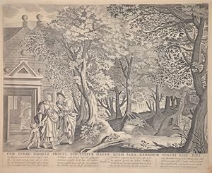
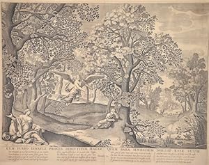
Cum puerro Ismaele procul dimittitur Hagar, quem Sara Haeredem noluvit esse suit
Published by Artist: Witde/ Schutt P Frederick ( - 1698 ) Amsterdam ; issued in: Amsterdam ; ca: 1730; - Frederik de Wit (1610 ? 1698) His Atlas began to appear around 1662 and by 1671 included anywhere from 17 to 151 maps each In the 1690s he began to use a new title page "Atlas Maior" but continued to use his old title page His atlas of the Low Countries first published in 1667was named Nieuw Kaertboeck van de XVII Nederlandse Provinci�n and contained 14 to 25 maps Frederik de Wit quickly expanded upon his first small folio atlas which contained mostly maps printed from plates that he had acquired to an atlas with 27 maps engraved by or for him By 1671 he was publishing a large folio atlas with as many as 100 maps Smaller atlases of 17 or 27 or 51 map, 1610
Seller: Antique Sommer& Sapunaru KG, M�nchen, Germany
Seller Rating:
Art / Print / Poster
Technic: Copper print; colorit: black/white; condition: Very good, size (in cm): 40 x 50,5; - Biblical scene of the New Testament, Genesis 21, with beautiful and decorative view and staffage; - Special feature: From Historiae Sacrae, New Testament.
-
Cum Puero Ismaele procul dimittitur Hagar, quem Sara Haeredem noluit esse suum
Published by Artist: Witde/ Schutt P Frederick ( - 1698 ) Amsterdam ; issued in: Amsterdam ; ca: 1730; - Frederik de Wit (1610 ? 1698) His Atlas began to appear around 1662 and by 1671 included anywhere from 17 to 151 maps each In the 1690s he began to use a new title page "Atlas Maior" but continued to use his old title page His atlas of the Low Countries first published in 1667was named Nieuw Kaertboeck van de XVII Nederlandse Provinci�n and contained 14 to 25 maps Frederik de Wit quickly expanded upon his first small folio atlas which contained mostly maps printed from plates that he had acquired to an atlas with 27 maps engraved by or for him By 1671 he was publishing a large folio atlas with as many as 100 maps Smaller atlases of 17 or 27 or 51 map, 1610
Seller: Antique Sommer& Sapunaru KG, M�nchen, Germany
Seller Rating:
Art / Print / Poster
Technic: Copper print; colorit: black/white; condition: Very good, size (in cm): 40 x 52; - Biblical scene of the New Testament, Genesis 21, with beautiful and decorative view and staffage; - Special feature: From Historiae Sacrae, New Testament.
-
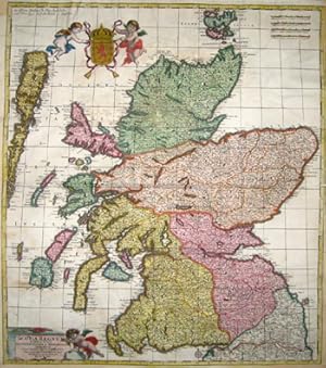
Scotia regnum divisum in Partem Septentrionalem et Meridionalem.
Published by Artist: Wit de Frederick ( - 1698 ) Amsterdam ; issued in: Amsterdam ; ca: 1688; - Frederik de Wit (1610 ? 1698) His Atlas began to appear around 1662 and by 1671 included anywhere from 17 to 151 maps each In the 1690s he began to use a new title page "Atlas Maior" but continued to use his old title page His atlas of the Low Countries first published in 1667was named Nieuw Kaertboeck van de XVII Nederlandse Provinci�n and contained 14 to 25 maps Frederik de Wit quickly expanded upon his first small folio atlas which contained mostly maps printed from plates that he had acquired to an atlas with 27 maps engraved by or for him By 1671 he was publishing a large folio atlas with as many as 100 maps Smaller atlases of 17 or 27 or 51 maps could s, 1610
Seller: Antique Sommer& Sapunaru KG, M�nchen, Germany
Seller Rating:
Technic: Copper print; colorit: original colored; condition: Upper and lower center restored, missing parts replaced, 3 margins enlarged, size (in cm): 57 x 50,5; - Map shows total Scotia with beautiful heraldics.
-

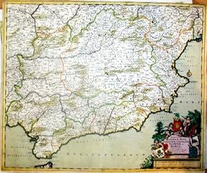
Regnorum Castellae Novae, Andalusiae, Granadae Valentiae, et Murciae
Published by Artist: Wit de Frederick ( - 1698 ) Amsterdam ; issued in: Amsterdam ; ca: 1690; - Frederik de Wit (1610 ? 1698) His Atlas began to appear around 1662 and by 1671 included anywhere from 17 to 151 maps each In the 1690s he began to use a new title page "Atlas Maior" but continued to use his old title page His atlas of the Low Countries first published in 1667was named Nieuw Kaertboeck van de XVII Nederlandse Provinci�n and contained 14 to 25 maps Frederik de Wit quickly expanded upon his first small folio atlas which contained mostly maps printed from plates that he had acquired to an atlas with 27 maps engraved by or for him By 1671 he was publishing a large folio atlas with as many as 100 maps Smaller atlases of 17 or 27 or 51 maps could s, 1610
Seller: Antique Sommer& Sapunaru KG, M�nchen, Germany
Seller Rating:
Technic: Copper print; colorit: original colored; condition: old coloring deposited, size (in cm): 49,5 x 59 cm; - MVery decorative map shows southern Spain with the whole of Andalusia, Castile, Granada, Valentia, Murcia and Gibraltar. Furthermore, a splendid title cartouche decorated with the corresponding coats of arms held by three putti. In prehistoric and early historical times, Iberians, Celts and Basques settled on the Iberian Peninsula, named after the former. In the 11th century BC, the Phoenicians settled on the south coast; the most famous of their colonies was C�diz.
-
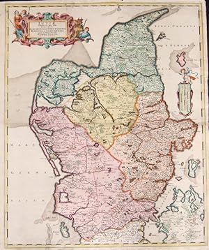
Iutiae Tabula in qua sunt Dioeces Alburgensis, Wiburgensis, Ripensis et Arhusiensis.
Published by Artist: Wit de Frederick ( - 1698 ) Amsterdam ; issued in: Amsterdam ; ca: 1680; - Frederik de Wit (1610 ? 1698) His Atlas began to appear around 1662 and by 1671 included anywhere from 17 to 151 maps each In the 1690s he began to use a new title page "Atlas Maior" but continued to use his old title page His atlas of the Low Countries first published in 1667was named Nieuw Kaertboeck van de XVII Nederlandse Provinci�n and contained 14 to 25 maps Frederik de Wit quickly expanded upon his first small folio atlas which contained mostly maps printed from plates that he had acquired to an atlas with 27 maps engraved by or for him By 1671 he was publishing a large folio atlas with as many as 100 maps Smaller atlases of 17 or 27 or 51 maps could s, 1610
Seller: Antique Sommer& Sapunaru KG, M�nchen, Germany
Seller Rating:
Technic: Copper print; colorit: original colored; condition: Perfect condition, size (in cm): 57,5 x 47,5; - Map shows Jutland the western part of Denmark, magnificent cartouche and mileage indicator with putto. It is located on the Kimbrian Peninsula and extends from the Danish border between Germany and Denmark to the Grenen Peninsula north of Skagen. Thus Jutland forms the Danish mainland, all other parts of Denmark are on islands. Until 1864, the southern border of Denmark was the southern border of the Duchy of Schleswig, which extended roughly from Kiel to the mouth of the Eider River near T�nning, the so-called Eider border.Since 1920, the Danish southern border has been a connecting line from Flensburg to Margretekoog in Denmark.
-

Duacum; Vulgo Dovay.
Published by Artist: Wit de Frederick ( - 1698 ) Amsterdam ; issued in: Amsterdam ; ca: 1650; - Frederik de Wit (1610 ? 1698) His Atlas began to appear around 1662 and by 1671 included anywhere from 17 to 151 maps each In the 1690s he began to use a new title page "Atlas Maior" but continued to use his old title page His atlas of the Low Countries first published in 1667was named Nieuw Kaertboeck van de XVII Nederlandse Provinci�n and contained 14 to 25 maps Frederik de Wit quickly expanded upon his first small folio atlas which contained mostly maps printed from plates that he had acquired to an atlas with 27 maps engraved by or for him By 1671 he was publishing a large folio atlas with as many as 100 maps Smaller atlases of 17 or 27 or 51 maps could s, 1610
Seller: Antique Sommer& Sapunaru KG, M�nchen, Germany
Seller Rating:
Technic: Copper print; colorit: original colored; condition: Very good, size (in cm): 41 x 51; - Detailed and decorative bird_ eye view of Dovai in France. Map with two decorative cartouches and Coat of arms. Its site probably corresponds to that of a 4th-century Roman fortress known as Duacum. From 10th century the town was a romance fiefdom of the counts of Flanders. The town became a flourishing textile market centre during the Middle Ages, historically known as Douay or Doway in English. In 1384, the county of Flanders passed into the domains of the Dukes of Burgundy and thence in 1477 into Habsburg possessions.
-
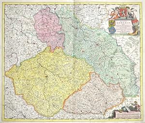
Regnum Bohemia, Annexae Provinciae, ut Ducatus Silesia, Marchionatus Moravia, et Lusatia.
Published by Artist: Wit de Frederick ( - 1698 ) Amsterdam ; issued in: Amsterdam ; ca: 1650; - Frederik de Wit (1610 ? 1698) His Atlas began to appear around 1662 and by 1671 included anywhere from 17 to 151 maps each In the 1690s he began to use a new title page "Atlas Maior" but continued to use his old title page His atlas of the Low Countries first published in 1667was named Nieuw Kaertboeck van de XVII Nederlandse Provinci�n and contained 14 to 25 maps Frederik de Wit quickly expanded upon his first small folio atlas which contained mostly maps printed from plates that he had acquired to an atlas with 27 maps engraved by or for him By 1671 he was publishing a large folio atlas with as many as 100 maps Smaller atlases of 17 or 27 or 51 maps could s, 1610
Seller: Antique Sommer& Sapunaru KG, M�nchen, Germany
Seller Rating:
Technic: Copper print; colorit: original colored; condition: Some restoration at the center, size (in cm): 48 x 57 cm; - Map shows Bohemia, Silesia, Maehren, Lausitz and Teschen. Decorative and detailed map with the cities of Olomouc, Hradisch, Breslau, _aga_ (German Sagan), Swidnica (German Schweidnitz). Furthermore a magnificent title cartouche with the coats of arms of Bohemia, Silesia, Moravia and Lusatia.
-
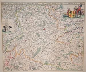
Comitatus Hannoniae et episcopatus Cambresis descriptio, Auctore F. de Wit.
Published by Artist: Wit de Frederick ( - 1698 ) Amsterdam ; issued in: Amsterdam ; ca: 1670; - Frederik de Wit (1610 ? 1698) His Atlas began to appear around 1662 and by 1671 included anywhere from 17 to 151 maps each In the 1690s he began to use a new title page "Atlas Maior" but continued to use his old title page His atlas of the Low Countries first published in 1667was named Nieuw Kaertboeck van de XVII Nederlandse Provinci�n and contained 14 to 25 maps Frederik de Wit quickly expanded upon his first small folio atlas which contained mostly maps printed from plates that he had acquired to an atlas with 27 maps engraved by or for him By 1671 he was publishing a large folio atlas with as many as 100 maps Smaller atlases of 17 or 27 or 51 maps could s, 1610
Seller: Antique Sommer& Sapunaru KG, M�nchen, Germany
Seller Rating:
Technic: Copper print; colorit: original colored; condition: Perfect condition, size (in cm): 47 x 55 cm; - Map shows the province of Hainaut in Belgium (partly France) with the city of Mons, Tournai, Ath, Charleroi, Walcourt, Maubeuge, Aymries, Dour, Valenciennes, La Cateau-Cambr�sis and many more. Furthermore, on the upper right a cartouche with warriors and the coat of arms of Hainaut, on the left a mileage scale held by two putti.
-
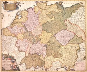
S.R.I.Germania descriptio.
Published by Artist: Wit de Frederick ( - 1698 ) Amsterdam ; issued in: Amsterdam ; ca: 1680; - Frederik de Wit (1610 ? 1698) His Atlas began to appear around 1662 and by 1671 included anywhere from 17 to 151 maps each In the 1690s he began to use a new title page "Atlas Maior" but continued to use his old title page His atlas of the Low Countries first published in 1667was named Nieuw Kaertboeck van de XVII Nederlandse Provinci�n and contained 14 to 25 maps Frederik de Wit quickly expanded upon his first small folio atlas which contained mostly maps printed from plates that he had acquired to an atlas with 27 maps engraved by or for him By 1671 he was publishing a large folio atlas with as many as 100 maps Smaller atlases of 17 or 27 or 51 maps could s, 1610
Seller: Antique Sommer& Sapunaru KG, M�nchen, Germany
Seller Rating:
Technic: Copper print; colorit: original colored; condition: Mounted, some restorations at the old coloured parts, size (in cm): 50 x 60 cm; - Map shows the whole of Germany with Bohemia, Silesia, Austria, Switzerland, the Netherlands and two magnificent cartouches.
-
Carta noua accurata del Passagio et strada dalli Paesi Bassi per via Allemagna per Italia et per via di Paesi Suizeri a Geneua, Lione et Roma per.
Published by Artist: Wit de Frederick ( - 1698 ) Amsterdam ; issued in: Amsterdam ; dated: 1671; - Frederik de Wit (1610 ? 1698) His Atlas began to appear around 1662 and by 1671 included anywhere from 17 to 151 maps each In the 1690s he began to use a new title page "Atlas Maior" but continued to use his old title page His atlas of the Low Countries first published in 1667was named Nieuw Kaertboeck van de XVII Nederlandse Provinci�n and contained 14 to 25 maps Frederik de Wit quickly expanded upon his first small folio atlas which contained mostly maps printed from plates that he had acquired to an atlas with 27 maps engraved by or for him By 1671 he was publishing a large folio atlas with as many as 100 maps Smaller atlases of 17 or 27 or 51 maps coul, 1610
Seller: Antique Sommer& Sapunaru KG, M�nchen, Germany
Seller Rating:
Technic: Copper print; colorit: original colored; condition: Some restoration at lower centerfold, size (in cm): 47,5 x 56; - Map shows southern Germany with cockroaches, Bavaria, Switzerland, South Tyrol, Luxembourg and partly Austria. It also shows a title cartouche with a mileage indicator and an index above.
-
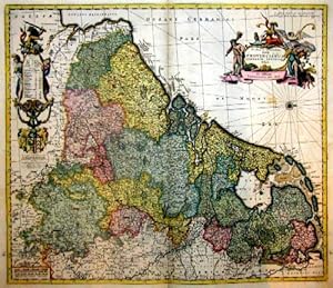
Novissima et accuratissimaXVII provinciarum germaniae inferioris tabula
Published by Artist: Wit de Frederick ( - 1698 ) Amsterdam ; issued in: Amsterdam ; ca: 1650; - Frederik de Wit (1610 ? 1698) His Atlas began to appear around 1662 and by 1671 included anywhere from 17 to 151 maps each In the 1690s he began to use a new title page "Atlas Maior" but continued to use his old title page His atlas of the Low Countries first published in 1667was named Nieuw Kaertboeck van de XVII Nederlandse Provinci�n and contained 14 to 25 maps Frederik de Wit quickly expanded upon his first small folio atlas which contained mostly maps printed from plates that he had acquired to an atlas with 27 maps engraved by or for him By 1671 he was publishing a large folio atlas with as many as 100 maps Smaller atlases of 17 or 27 or 51 maps could s, 1610
Seller: Antique Sommer& Sapunaru KG, M�nchen, Germany
Seller Rating:
Technic: Copper print; colorit: original colored; condition: Very good, size (in cm): 47 x 57; - Map shows total Netherlands.
-

Novissima Regnorum Portugalliae et Algarbiae
Published by Artist: Wit de Frederick ( - 1698 ) Amsterdam ; issued in: Amsterdam ; ca: 1670; - Frederik de Wit (1610 ? 1698) His Atlas began to appear around 1662 and by 1671 included anywhere from 17 to 151 maps each In the 1690s he began to use a new title page "Atlas Maior" but continued to use his old title page His atlas of the Low Countries first published in 1667was named Nieuw Kaertboeck van de XVII Nederlandse Provinci�n and contained 14 to 25 maps Frederik de Wit quickly expanded upon his first small folio atlas which contained mostly maps printed from plates that he had acquired to an atlas with 27 maps engraved by or for him By 1671 he was publishing a large folio atlas with as many as 100 maps Smaller atlases of 17 or 27 or 51 maps could s, 1610
Seller: Antique Sommer& Sapunaru KG, M�nchen, Germany
Seller Rating:
Technic: Copper print; colorit: original colored; condition: Some restorations due to original color, size (in cm): 58 x 48,5 cm; - Map shows the whole of Portugal with two magnificent cartouches and two coats of arms (Portugal, Algarve).
-
Regnorum castellae novae Andalusiae, Granadae, Valenciae et Murcia
Published by Artist: Wit de Frederick ( - 1698 ) Amsterdam ; issued in: Amsterdam ; ca: 1650; - Frederik de Wit (1610 ? 1698) His Atlas began to appear around 1662 and by 1671 included anywhere from 17 to 151 maps each In the 1690s he began to use a new title page "Atlas Maior" but continued to use his old title page His atlas of the Low Countries first published in 1667was named Nieuw Kaertboeck van de XVII Nederlandse Provinci�n and contained 14 to 25 maps Frederik de Wit quickly expanded upon his first small folio atlas which contained mostly maps printed from plates that he had acquired to an atlas with 27 maps engraved by or for him By 1671 he was publishing a large folio atlas with as many as 100 maps Smaller atlases of 17 or 27 or 51 maps could s, 1610
Seller: Antique Sommer& Sapunaru KG, M�nchen, Germany
Seller Rating:
Technic: Copper print; colorit: original colored; condition: Lower margin perfectly restored, size (in cm): 59 x 49,50 cm; - Very decorative map showing southern Spain with all of Andalusia, Castile, Granada, Valentia, Murcia and Gibraltar. Furthermore, a magnificent title cartouche decorated with the corresponding coats of arms held by three putti.
-
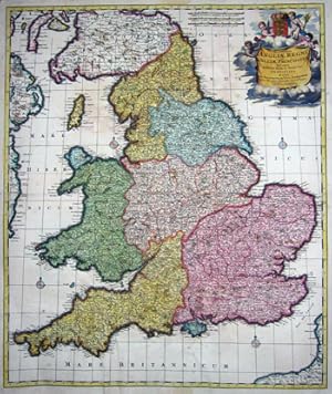
Accuratissima Angliae regni et Walliae Principatus descriptio.
Published by Artist: Wit de Frederick ( - 1698 ) Amsterdam ; issued in: Amsterdam ; ca: 1670; - Frederik de Wit (1610 ? 1698) His Atlas began to appear around 1662 and by 1671 included anywhere from 17 to 151 maps each In the 1690s he began to use a new title page "Atlas Maior" but continued to use his old title page His atlas of the Low Countries first published in 1667was named Nieuw Kaertboeck van de XVII Nederlandse Provinci�n and contained 14 to 25 maps Frederik de Wit quickly expanded upon his first small folio atlas which contained mostly maps printed from plates that he had acquired to an atlas with 27 maps engraved by or for him By 1671 he was publishing a large folio atlas with as many as 100 maps Smaller atlases of 17 or 27 or 51 maps could s, 1610
Seller: Antique Sommer& Sapunaru KG, M�nchen, Germany
Seller Rating:
Technic: Copper print; colorit: original colored; condition: Map partly mounted, size (in cm): 57 x 48; - Map shows total England with beautyfull heraldic cartouche.
-

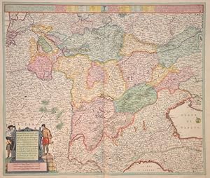
Circulus Suevicus in quo sunt Ducatus Wirtenbergensis, Marchionatus Badensis & Burgoviensis Comitatus Otting, Rechberg, Konigsek, Hohenzolern, & .
Published by Artist: Wit de Frederick ( - 1698 ) Amsterdam ; issued in: Amsterdam ; ca: 1695; - Frederik de Wit (1610 ? 1698) His Atlas began to appear around 1662 and by 1671 included anywhere from 17 to 151 maps each In the 1690s he began to use a new title page "Atlas Maior" but continued to use his old title page His atlas of the Low Countries first published in 1667was named Nieuw Kaertboeck van de XVII Nederlandse Provinci�n and contained 14 to 25 maps Frederik de Wit quickly expanded upon his first small folio atlas which contained mostly maps printed from plates that he had acquired to an atlas with 27 maps engraved by or for him By 1671 he was publishing a large folio atlas with as many as 100 maps Smaller atlases of 17 or 27 or 51 maps could s, 1610
Seller: Antique Sommer& Sapunaru KG, M�nchen, Germany
Seller Rating:
Technic: Copper print; colorit: original colored; condition: Centerfold and tear on left side perfectly restored, size (in cm): 48,5 x 57,5 cm; - Decorative map of Suabia with the cities of Augsburg, Ulm, Memmingen, Kempten, N�rdlingen, Lindau at Bodensee and others.; Baden-W�rttemberg with Constanz, T�bingen, Stuttgart, Heidelberg, Pforzheim, Freiburg im Breisgau.
-
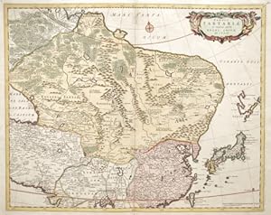
Tabula Tartariae et majoris partis Regni Chinae.
Published by Artist: Wit de Frederick ( - 1698 ) Amsterdam ; issued in: Amsterdam ; ca: 1670; - Frederik de Wit (1610 ? 1698) His Atlas began to appear around 1662 and by 1671 included anywhere from 17 to 151 maps each In the 1690s he began to use a new title page "Atlas Maior" but continued to use his old title page His atlas of the Low Countries first published in 1667was named Nieuw Kaertboeck van de XVII Nederlandse Provinci�n and contained 14 to 25 maps Frederik de Wit quickly expanded upon his first small folio atlas which contained mostly maps printed from plates that he had acquired to an atlas with 27 maps engraved by or for him By 1671 he was publishing a large folio atlas with as many as 100 maps Smaller atlases of 17 or 27 or 51 maps could s, 1610
Seller: Antique Sommer& Sapunaru KG, M�nchen, Germany
Seller Rating:
Technic: Copper print; colorit: original colored; condition: Some restoration at lower centerfold, size (in cm): 43,5 x 54,5 cm; - Map shows Tartaria ( notheeast of Russia), total China, Japan and partly India with a decorative title cartouche.
-
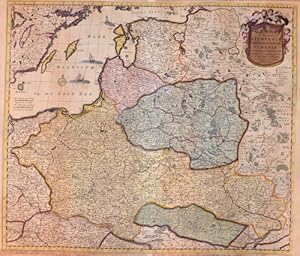
Regni Poloniae et Ducatus Lithuaniae Voliniae, Podoliae Ucraniae Prussiae et Curlandiae
Published by Artist: Wit de Frederick ( - 1698 ) Amsterdam ; issued in: Amsterdam ; ca: 1670; - Frederik de Wit (1610 ? 1698) His Atlas began to appear around 1662 and by 1671 included anywhere from 17 to 151 maps each In the 1690s he began to use a new title page "Atlas Maior" but continued to use his old title page His atlas of the Low Countries first published in 1667was named Nieuw Kaertboeck van de XVII Nederlandse Provinci�n and contained 14 to 25 maps Frederik de Wit quickly expanded upon his first small folio atlas which contained mostly maps printed from plates that he had acquired to an atlas with 27 maps engraved by or for him By 1671 he was publishing a large folio atlas with as many as 100 maps Smaller atlases of 17 or 27 or 51 maps could s, 1610
Seller: Antique Sommer& Sapunaru KG, M�nchen, Germany
Seller Rating:
Technic: Copper print; colorit: original colored; condition: Some restorations along the orig. outline colours, size (in cm): 48 x 56 cm; - Detailed map of Poland, Lithuania, Latvia and a titelcartouche.
-
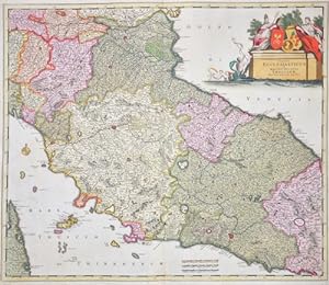
Satus Ecclesiasticus et Magnus ducatus Thoscanae
Published by Artist: Wit de Frederick ( - 1698 ) Amsterdam ; issued in: Amsterdam ; ca: 1660; - Frederik de Wit (1610 ? 1698) His Atlas began to appear around 1662 and by 1671 included anywhere from 17 to 151 maps each In the 1690s he began to use a new title page "Atlas Maior" but continued to use his old title page His atlas of the Low Countries first published in 1667was named Nieuw Kaertboeck van de XVII Nederlandse Provinci�n and contained 14 to 25 maps Frederik de Wit quickly expanded upon his first small folio atlas which contained mostly maps printed from plates that he had acquired to an atlas with 27 maps engraved by or for him By 1671 he was publishing a large folio atlas with as many as 100 maps Smaller atlases of 17 or 27 or 51 maps could s, 1610
Seller: Antique Sommer& Sapunaru KG, M�nchen, Germany
Seller Rating:
Technic: Copper print; colorit: original colored; condition: Some restoration at lower centerfold, size (in cm): 49 x 57,5 cm; - Map shows central Italy, the whole of Tuscany with the cities of Pisa, Livorno, Bologna, Florence, Ferrara, Ravenna, Urbino, Siena, Orvieto, Spoleto, Rome, etc., the island of Elba and a magnificent cartridge.; - Special feature: Royal edition, heightened with gold, rare.
-
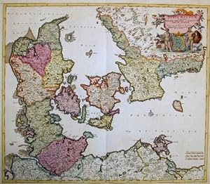
Dania regnum In quo sunt Ducatus Holsatia et Slesvicum Insulae Danicae et Provinciae Jutia, Scania, Blekingia et Hallandia
Published by Artist: Wit de Frederick ( - 1698 ) Amsterdam ; issued in: Amsterdam ; ca: 1688; - Frederik de Wit (1610 ? 1698) His Atlas began to appear around 1662 and by 1671 included anywhere from 17 to 151 maps each In the 1690s he began to use a new title page "Atlas Maior" but continued to use his old title page His atlas of the Low Countries first published in 1667was named Nieuw Kaertboeck van de XVII Nederlandse Provinci�n and contained 14 to 25 maps Frederik de Wit quickly expanded upon his first small folio atlas which contained mostly maps printed from plates that he had acquired to an atlas with 27 maps engraved by or for him By 1671 he was publishing a large folio atlas with as many as 100 maps Smaller atlases of 17 or 27 or 51 maps could s, 1610
Seller: Antique Sommer& Sapunaru KG, M�nchen, Germany
Seller Rating:
Technic: Copper print; colorit: original colored; condition: Some restoration at lower centerfold, size (in cm): 50 x 58; - Map shows total Denmark.
-

Regnum Neapolis in quo sunt Aprutium Ulterius et Citerius, comitatus Molisius, Terra la Boris, Capitaniata Principatus ulterior.
Published by Artist: Wit de Frederick ( - 1698 ) Amsterdam ; issued in: Amsterdam ; ca: 1670; - Frederik de Wit (1610 ? 1698) His Atlas began to appear around 1662 and by 1671 included anywhere from 17 to 151 maps each In the 1690s he began to use a new title page "Atlas Maior" but continued to use his old title page His atlas of the Low Countries first published in 1667was named Nieuw Kaertboeck van de XVII Nederlandse Provinci�n and contained 14 to 25 maps Frederik de Wit quickly expanded upon his first small folio atlas which contained mostly maps printed from plates that he had acquired to an atlas with 27 maps engraved by or for him By 1671 he was publishing a large folio atlas with as many as 100 maps Smaller atlases of 17 or 27 or 51 maps could s, 1610
Seller: Antique Sommer& Sapunaru KG, M�nchen, Germany
Seller Rating:
Technic: Copper print; colorit: original colored; condition: Perfect condition, size (in cm): 58 x 49 cm; - Map shows the whole of southern Italy with part of Sicily and the Lipari Islands. Furthermore, a title cartouche with 12 coats of arms from the region. Below a cartouche with mileage indicator and the coat of arms of the Kingdom of Naples with two putti depictions.
-
Cimbebas et Caffariae Littora a Catembela ad Promontorium Boan Spei.
Published by Artist: Wit de Frederick ( - 1698 ) Amsterdam ; issued in: Amsterdam ; ca: 1675; - Frederik de Wit (1610 ? 1698) His Atlas began to appear around 1662 and by 1671 included anywhere from 17 to 151 maps each In the 1690s he began to use a new title page "Atlas Maior" but continued to use his old title page His atlas of the Low Countries first published in 1667was named Nieuw Kaertboeck van de XVII Nederlandse Provinci�n and contained 14 to 25 maps Frederik de Wit quickly expanded upon his first small folio atlas which contained mostly maps printed from plates that he had acquired to an atlas with 27 maps engraved by or for him By 1671 he was publishing a large folio atlas with as many as 100 maps Smaller atlases of 17 or 27 or 51 maps could s, 1610
Seller: Antique Sommer& Sapunaru KG, M�nchen, Germany
Seller Rating:
Map
Technic: Copper print; colorit: original colored; condition: Very good, size (in cm): 42,5 x 55; - Map shows the Atlatic with the western coast of Africa; - Special feature: Royal edition, heightened with gold, rare.
-
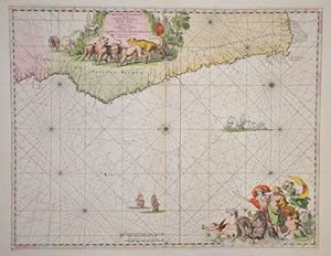
Finnmarchiae et Lapplandiae Maritima
Published by Artist: Wit de Frederick ( - 1698 ) Amsterdam ; issued in: Amsterdam ; ca: 1739; - Frederik de Wit (1610 ? 1698) His Atlas began to appear around 1662 and by 1671 included anywhere from 17 to 151 maps each In the 1690s he began to use a new title page "Atlas Maior" but continued to use his old title page His atlas of the Low Countries first published in 1667was named Nieuw Kaertboeck van de XVII Nederlandse Provinci�n and contained 14 to 25 maps Frederik de Wit quickly expanded upon his first small folio atlas which contained mostly maps printed from plates that he had acquired to an atlas with 27 maps engraved by or for him By 1671 he was publishing a large folio atlas with as many as 100 maps Smaller atlases of 17 or 27 or 51 maps could s, 1610
Seller: Antique Sommer& Sapunaru KG, M�nchen, Germany
Seller Rating:
Map
Technic: Copper print; colorit: original colored; condition: Some restorations, size (in cm): 50 x 57; - Map shows the Nothpole Sea with Lappland parts of Finnalnd and Norwege. Die Anrainerstaaten der Ostsee sind Deutschland, D�nemark, Schweden, Finnland, Russland, Estland, Lettland, Litauen und Polen.
-
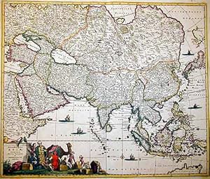
Asiae Tabula Recens Emendata.
Published by Artist: Wit de Frederick ( - 1698 ) Amsterdam ; issued in: Amsterdam ; ca: 1680; - Frederik de Wit (1610 ? 1698) His Atlas began to appear around 1662 and by 1671 included anywhere from 17 to 151 maps each In the 1690s he began to use a new title page "Atlas Maior" but continued to use his old title page His atlas of the Low Countries first published in 1667was named Nieuw Kaertboeck van de XVII Nederlandse Provinci�n and contained 14 to 25 maps Frederik de Wit quickly expanded upon his first small folio atlas which contained mostly maps printed from plates that he had acquired to an atlas with 27 maps engraved by or for him By 1671 he was publishing a large folio atlas with as many as 100 maps Smaller atlases of 17 or 27 or 51 maps could s, 1610
Seller: Antique Sommer& Sapunaru KG, M�nchen, Germany
Seller Rating:
Technic: Copper print; colorit: original colored; condition: Very good, size (in cm): 49 x 57; - Map shows total Asia with beautiful cartouche showing a camel , cockatoos and natives.
-
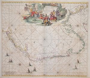
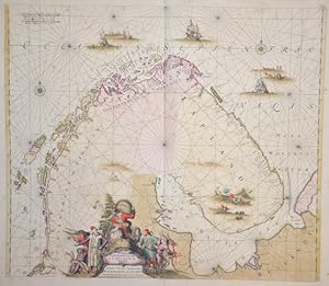
Norvegiae Maritimae ab Elf-burgo ad Dronten / Pascaert van Noorwegen streckende van Elf-burg tot Dronten
Published by Artist: Wit de Frederick ( - 1698 ) Amsterdam ; issued in: Amsterdam ; ca: 1670; - Frederik de Wit (1610 ? 1698) His Atlas began to appear around 1662 and by 1671 included anywhere from 17 to 151 maps each In the 1690s he began to use a new title page "Atlas Maior" but continued to use his old title page His atlas of the Low Countries first published in 1667was named Nieuw Kaertboeck van de XVII Nederlandse Provinci�n and contained 14 to 25 maps Frederik de Wit quickly expanded upon his first small folio atlas which contained mostly maps printed from plates that he had acquired to an atlas with 27 maps engraved by or for him By 1671 he was publishing a large folio atlas with as many as 100 maps Smaller atlases of 17 or 27 or 51 maps could s, 1610
Seller: Antique Sommer& Sapunaru KG, M�nchen, Germany
Seller Rating:
Map
Technic: Copper print; colorit: original colored; condition: Very good, size (in cm): 49 x 56,50; - Map shows the Norwegian coast between Trondheim and Swedish border to Oslo.
