
Order Total (1 Item Items):
Shipping Destination:

family man publishing (90 results)
Feedback
Skip to main search results
Search filters
Product Type
- All Product Types
- Books (90)
- Magazines & Periodicals (No further results match this refinement)
- Comics (No further results match this refinement)
- Sheet Music (No further results match this refinement)
- Art, Prints & Posters (No further results match this refinement)
- Photographs (No further results match this refinement)
- Maps (No further results match this refinement)
- Manuscripts & Paper Collectibles (No further results match this refinement)
Condition
Binding
Collectible Attributes
- First Edition (3)
- Signed (No further results match this refinement)
- Dust Jacket (1)
- Seller-Supplied Images (77)
- Not Print on Demand (90)
Free Shipping
Seller Rating
-

Lies Homeschooling Moms Believe
Published by Family Man Publishing, 2006
ISBN 10: 1933858141 ISBN 13: 9781933858142
Seller: Wonder Book, Frederick, MD, U.S.A.
Seller rating 5 out of 5 stars

Condition: Good. Good condition. A copy that has been read but remains intact. May contain markings such as bookplates, stamps, limited notes and highlighting, or a few light stains.
More buying choices from other sellers on AbeBooks
New offers from US$ 30.49
Used offers from US$ 5.78
-
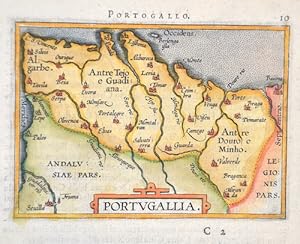
Portogallo. 10 / Portugallia.
Published by Artist: Ortelius Abraham ( - 1598 ) Antwerp ; issued in: Antwerp; - Abraham Ortelius (1527 - 1598) Antwerp comes from an Augsburg family and was born in Antwerp Spain where he lived throughout his life After thorough training he joined the Antwerp Guild of St Luke in 1547 as a card painter In 1554 he took over an antiquarian bookshop that mainly deals with the coloring distribution and publishing of maps Basically he is more of a publisher than a scholar And so he also made the acquaintance of another great man of his time Gerhard Mercator (1512-1594) who encouraged him to draw cards and to make maps of the most varied of countries His first cartographic work of his own is a large 8-sheet map of the world that appears in Antwerp in 1564 Thi, 1527
Seller: Antique Sommer& Sapunaru KG, M�nchen, Germany
Seller rating 4 out of 5 stars

Technic: Copper print, colorit: original colored, condition: Perfect condition, size (in cm): 8 x 10,5 cm; - Map shows the whole of Portugal with a title cartouche.; History: Portugal is the oldest state on the Iberian Peninsula and one of the oldest in Europe, its territory having been continuously settled, invaded and fought over since prehistoric times. The pre-Celtic people, Celts, Carthaginians and Romans were followed by the invasions of the Visigoths and Suebi Germanic peoples. In the 15th and 16th centuries, Portugal established the first global empire, becoming one of the world's major economic, political and military powers. During this period, today referred to as the Age of Discovery, Portuguese explorers pioneered maritime exploration, notably under royal patronage of Prince Henry the Navigator and King John II, with such notable voyages as Bartolomeu Dias' sailing beyond the Cape of Good Hope (1488), Vasco da Gama's discovery of the sea route to India (1497?98) and the European discovery of Brazil (1500). During this time Portugal monopolized the spice trade, divided the world into hemispheres of dominion with Castille, and the empire expanded with military campaigns in Asia. However, events such as the 1755 Lisbon earthquake, the country's occupation during the Napoleonic Wars, the independence of Brazil (1822), and a late industrialization compared to other European powers, erased to a great extent Portugal's prior opulence.
-
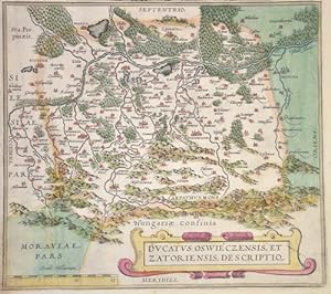
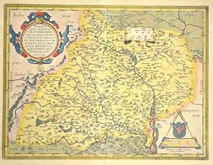
Ducatus Oswieczensis, et Zatoriensis, descriptio
Published by Artist: Ortelius Abraham ( - 1598 ) Antwerp ; issued in: Antwerp; - Abraham Ortelius (1527 - 1598) Antwerp comes from an Augsburg family and was born in Antwerp Spain where he lived throughout his life After thorough training he joined the Antwerp Guild of St Luke in 1547 as a card painter In 1554 he took over an antiquarian bookshop that mainly deals with the coloring distribution and publishing of maps Basically he is more of a publisher than a scholar And so he also made the acquaintance of another great man of his time Gerhard Mercator (1512-1594) who encouraged him to draw cards and to make maps of the most varied of countries His first cartographic work of his own is a large 8-sheet map of the world that appears in Antwerp in 1564 Thi, 1527
Seller: Antique Sommer& Sapunaru KG, M�nchen, Germany
Seller rating 4 out of 5 stars
Technic: Copper print, colorit: original colored, condition: Trimmed, size (in cm): 22 x 24,5 cm; - Detailed map of southern Poland and the area from the Wesel in the north to the Carpathians in the south, with the towns of O_wi_cim (German Auschwitz), K_ty (German Kenty), Wadowice, Zator and _ywiec (Silesia). Furthermore, a title cartouche and a mileage indicator.; History: Poland is bordered by the Baltic Sea, Russia's Kaliningrad Oblast and Lithuania to the north, Belarus and Ukraine to the east, Slovakia and Czech Republic, to the south, and Germany to the west. The establishment of the Polish state can be traced back to AD 966, when Mieszko I ruler of the realm coextensive with the territory of present-day Poland, converted to Christianity. The Kingdom of Poland was founded in 1025, and in 1569 it cemented its longstanding political association with the Grand Duchy of Lithuania. This union formed the Polish?Lithuanian Commonwealth, one of the largest at the end of the 18th century. Poland regained its independence in 1918 with the Treaty of Versailles. It was one of the most populous countries of 16th- and 17th-century Europe, with a uniquely liberal political system, which adopted Europe's first written national constitution, the Constitution of 3 May 1791.
-
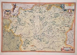
Lorraine. Lotharingiae nova descriptio.
Published by Artist: Ortelius Abraham ( - 1598 ) Antwerp ; issued in: Antwerp; - Abraham Ortelius (1527 - 1598) Antwerp comes from an Augsburg family and was born in Antwerp Spain where he lived throughout his life After thorough training he joined the Antwerp Guild of St Luke in 1547 as a card painter In 1554 he took over an antiquarian bookshop that mainly deals with the coloring distribution and publishing of maps Basically he is more of a publisher than a scholar And so he also made the acquaintance of another great man of his time Gerhard Mercator (1512-1594) who encouraged him to draw cards and to make maps of the most varied of countries His first cartographic work of his own is a large 8-sheet map of the world that appears in Antwerp in 1564 Thi, 1527
Seller: Antique Sommer& Sapunaru KG, M�nchen, Germany
Seller rating 4 out of 5 stars
Technic: Copper print, colorit: original colored, condition: Perfect condition, size (in cm): 34 x 50 cm; - Map shows the former Lorraine region with its capital Metz in France with three cartouches. The cities of Nancy, �pinal, Remiremont, Vaucoleur, Neuschateau, etc. are also depicted. Description in Latin on the reverse. - additional information: from "Theatrum Orbis Terrarum", latin edition; History: The area around the Moselle, populated mainly by Celtic tribes, was conquered by Gaius Iulius Caesar in the Gallic War between 58 and 51 BC and later became part of the Roman province of Gallia Belgica. From a division of the Frankish Empire into three parts, the Lotharii Regnum, the "Empire of Lothar" or Lotharingia, named after its king, emerged in 843. s lay in the middle between the East and West Frankish Empires and originally stretched as an elongated territory from the Mediterranean to the North Sea. In 870, the area was again divided between the East and West Frankish Empires.
-
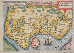
Thiedmarcia Holsaticaereg
Published by Artist: Ortelius Abraham ( - 1598 ) Antwerp ; issued in: ; - Abraham Ortelius (1527 - 1598) Antwerp comes from an Augsburg family and was born in Antwerp Spain where he lived throughout his life After thorough training he joined the Antwerp Guild of St Luke in 1547 as a card painter In 1554 he took over an antiquarian bookshop that mainly deals with the coloring distribution and publishing of maps Basically he is more of a publisher than a scholar And so he also made the acquaintance of another great man of his time Gerhard Mercator (1512-1594) who encouraged him to draw cards and to make maps of the most varied of countries His first cartographic work of his own is a large 8-sheet map of the world that appears in Antwerp in 1564 This is fo, 1527
Seller: Antique Sommer& Sapunaru KG, M�nchen, Germany
Seller rating 4 out of 5 stars
Technic: Copper print, colorit: original colored, condition: Very good, size (in cm): 7,5 x 10,5; - Map shows Dithmarschen in Schleswig Holsten. - additional information: From pocket atlas; History: After the Angling wave of emigration, Danish and Jutian settlers advanced northeast into the country. Around 770 they founded Haithabu, one of the most important trading centers of the early Middle Ages, and with the Danewerk they built a protective wall against the Saxons. In the course of the Saxon Wars, the southern part of the country came under the influence of the Franconian Empire. Between 768 and 811 there were repeated confrontations between the King of the Franconian Empire and later Christian Emperor Charlemagne and the pagan northern Germans, in the course of which the Danewerk was expanded. In a peace treaty in 811, the Eider was established as the border between the Carolingian and Danish empires. With the increasing settlement in the 12th and 13th centuries, the Eider border lost its real meaning as a dividing line, but it remained until the end of the Holy Roman Empire in 1806 and until 1864 as the border between Schleswig and Holstein. In the early 13th century the Danish king tried to integrate Holstein into his empire. However, after initial successes, it failed in the Battle of Bornh�ved in 1227 due to resistance from north German princes. In 1460, after the Schauenburgs died out, the Schleswig-Holstein knighthood directly elected the Danish King Christian I from the House of Oldenburg as sovereign, he was a nephew of the last Schauenburger Adolf VIII. While the Thirty Years War broke out in the south of the empire in 1618, they stayed Schleswig and Holstein were spared fighting for the time being and experienced a high phase due to the profitable agriculture. n the course of the 17th century, the contrast between the ducal and royal parts led to increasing conflicts between the two parties. The Gottorf Duchy demanded greater sovereignty and turned away from Denmark and instead turned to the Kingdom of Sweden. This culminated at the end of the century in a multiple occupation of the ducal portion by Denmark. The Great Northern War broke out at the beginning of the 18th century. Gottorf stood on the side of Sweden, which after the defeat of the kingdom in 1713 led to the complete annexation of the ducal share in Schleswig by Denmark. The former Gottorf Duchy then only had holdings in Holstein, the annexation was declared legal in the Peace of Frederiksborg in 1720. In 1800 the whole of Schleswig-Holstein - with the exception of the Principality of L�beck and the Duchy of Saxony-Lauenburg - was under Danish administration. The city of Altona, today a district of Hamburg, was the second largest city in the kingdom after Copenhagen. At the end of the Napoleonic Wars, Denmark found itself on the loser's side with broken finances. The emergence of nationalism in both Denmark and Germany led to a contradiction in terms of who the so-called Elbe duchies belonged to, which resulted in two wars. In both Germany and Denmark, the country was fully claimed by the nationally-minded liberals, although it was divided into a predominantly Danish-speaking and Danish-minded north and a predominantly German-speaking and German-minded south. The disagreement between the two areas led to the Schleswig-Holstein uprising, in which the German-minded people tried in vain to end Danish sovereignty. The London Protocol of 1852 guaranteed the continued existence of the entire state and stipulated that Schleswig should not be bound closer to the kingdom than Holstein, and the entire state was restored.
-
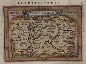
Transsilvanie. Transilvania
Published by Artist: Ortelius Abraham ( - 1598 ) Antwerp ; issued in: Antwerp; - Abraham Ortelius (1527 - 1598) Antwerp comes from an Augsburg family and was born in Antwerp Spain where he lived throughout his life After thorough training he joined the Antwerp Guild of St Luke in 1547 as a card painter In 1554 he took over an antiquarian bookshop that mainly deals with the coloring distribution and publishing of maps Basically he is more of a publisher than a scholar And so he also made the acquaintance of another great man of his time Gerhard Mercator (1512-1594) who encouraged him to draw cards and to make maps of the most varied of countries His first cartographic work of his own is a large 8-sheet map of the world that appears in Antwerp in 1564 Thi, 1527
Seller: Antique Sommer& Sapunaru KG, M�nchen, Germany
Seller rating 4 out of 5 stars
Technic: Copper print, colorit: colored, condition: Perfect condition, size (in cm): 9 x 12 cm; - Map shows Transylvania. With detailed representation of all cities, forests and mountains. - additional information: From the atlas minor; History: Transilvania is a historical region located in what is today the central part of Romania. Bound on the east and south by its natural borders, the Carpathian mountain range, historical Transylvania extended westward to the Apuseni Mountains. The region of Transylvania is known for the scenic beauty of its Carpathian landscape and its rich history. It also contains major cities such as Cluj-Napoca, Bra_ov, Sibiu and T�rgu Mure_. The Habsburgs acquired the territory shortly after the Battle of Vienna in 1683. In 1687, the rulers of Transylvania recognized the suzerainty of the Habsburg emperor Leopold I, and the region was officially attached to the Habsburg Empire.
-
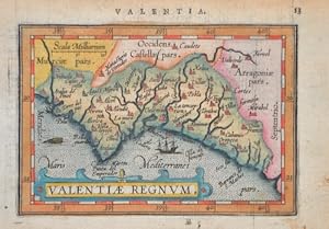
Valenciae Regnum. /Valentia. 13
Published by Artist: Ortelius Abraham ( - 1598 ) Antwerp ; issued in: Antwerp; - Abraham Ortelius (1527 - 1598) Antwerp comes from an Augsburg family and was born in Antwerp Spain where he lived throughout his life After thorough training he joined the Antwerp Guild of St Luke in 1547 as a card painter In 1554 he took over an antiquarian bookshop that mainly deals with the coloring distribution and publishing of maps Basically he is more of a publisher than a scholar And so he also made the acquaintance of another great man of his time Gerhard Mercator (1512-1594) who encouraged him to draw cards and to make maps of the most varied of countries His first cartographic work of his own is a large 8-sheet map of the world that appears in Antwerp in 1564 Thi, 1527
Seller: Antique Sommer& Sapunaru KG, M�nchen, Germany
Seller rating 4 out of 5 stars
Technic: Copper print, colorit: original colored, condition: Perfect condition, size (in cm): 9 x 12 cm; - Map shows the whole of Valencia with title cartouche, sea monster and two sailing ships. Latin edition of A. Ortelius' Epitome. Published by J. B. Vrients in Antwerp, 1609. - additional information: From pocket atlas; History: The Valencian Community, also Valencian Land is an autonomous community of Spain located on the Mediterranean coast. It borders Catalonia to the north, Aragon and Castile-La Mancha to the west, and Murcia to the south, and includes the three provinces of Valencia, Alicante and Castell�n de la Plana. The capital of the autonomous community is the city of Valencia. The territory of the Autonomous Community, formed in 1982, is largely identical to that of the former Kingdom of Valencia, which belonged to the Crown of Aragon. Most of the region belongs to the linguistic area of Valencian, a variety of Catalan. Valencian is an official language alongside Spanish.
-
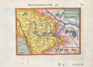
Wirtenburgum. 30. / Wirtenbergensis ducatus vera descriptio tubingae edita
Published by Artist: Ortelius Abraham ( - 1598 ) Antwerp ; issued in: Antwerp; - Abraham Ortelius (1527 - 1598) Antwerp comes from an Augsburg family and was born in Antwerp Spain where he lived throughout his life After thorough training he joined the Antwerp Guild of St Luke in 1547 as a card painter In 1554 he took over an antiquarian bookshop that mainly deals with the coloring distribution and publishing of maps Basically he is more of a publisher than a scholar And so he also made the acquaintance of another great man of his time Gerhard Mercator (1512-1594) who encouraged him to draw cards and to make maps of the most varied of countries His first cartographic work of his own is a large 8-sheet map of the world that appears in Antwerp in 1564 Thi, 1527
Seller: Antique Sommer& Sapunaru KG, M�nchen, Germany
Seller rating 4 out of 5 stars
Technic: Copper print, colorit: original colored, condition: Perfect condition, size (in cm): 8,5 x 10,5 cm; - Map shows W�rttemberg with Tuttlingen, Ulm, T�bingen, Heidelberg and many more. - additional information: From the pocket atlas Ortelius-Heyns Epitome; History: Baden-Wuertemberg is a state in southwest Germany, east of the Rhine, which forms the border with France. It is is formed from the historical territories of Baden, Prussian Hohenzollern, and W�rttemberg, and also parts of Swabia. Baden W�rtemberg was only founded in 1952 by the merger of the states of W�rttemberg-Baden, Baden and W�rttemberg-Hohenzollern. Today the most populous city of Baden-W�rttemberg is the state capital Stuttgart, followed by Karlsruhe and Mannheim. Other major cities are Freiburg im Breisgau, Heidelberg, Ulm, Heilbronn, Pforzheim and Reutlingen. The early modern period was marked by the Reformation and the expansion efforts of the emerging states of Austria, Prussia, France and Sweden. Conflicts such as the Peasant War, the Thirty Years' War and the Palatinate War of Succession resulted from these. One of the focal points of the fighting, with corresponding consequences for the population and the economy, was in what is today Baden-W�rttemberg, which remained extremely fragmented territorially. At the beginning of the 19th century, around 300 states still had territorial rights in what is now Baden-W�rttemberg, but their number was reduced to four after the dissolution of the Old Empire. The Kingdom of W�rttemberg and the Grand Duchy of Baden were among the winners of the coalition wars. The two principalities of Hohenzollern-Sigmaringen and Hohenzollern-Hechingen survived mediatization due to their special relationship with Napol�on. In 1849, the Baden Revolution was put down by Prussian intervention forces, the Baden army was dissolved and rebuilt under Prussian leadership. In 1850 the two Hohenzollern states became the Prussian province of Hohenzollernsche Lande. With the new formation of the tribal duchies, the southern areas of what is now the state of Baden-W�rttemberg belonged to the Duchy of Swabia until the end of the High Middle Ages, the northern areas were located with the Duchy of Franconia.
-
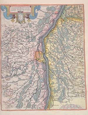
Argentoratensis agri descriptio.
Published by Artist: Ortelius Abraham ( - 1598 ) Antwerp ; issued in: Antwerp; - Abraham Ortelius (1527 - 1598) Antwerp comes from an Augsburg family and was born in Antwerp Spain where he lived throughout his life After thorough training he joined the Antwerp Guild of St Luke in 1547 as a card painter In 1554 he took over an antiquarian bookshop that mainly deals with the coloring distribution and publishing of maps Basically he is more of a publisher than a scholar And so he also made the acquaintance of another great man of his time Gerhard Mercator (1512-1594) who encouraged him to draw cards and to make maps of the most varied of countries His first cartographic work of his own is a large 8-sheet map of the world that appears in Antwerp in 1564 Thi, 1527
Seller: Antique Sommer& Sapunaru KG, M�nchen, Germany
Seller rating 4 out of 5 stars
Technic: Copper print, colorit: original colored, condition: Perfect condition, size (in cm): 30,5 x 25 cm; - Map shows Strasbourg with the Rhine and the surrounding area with the towns of Barr, Benfeld, Osthoffen, Offendorf, Drusenheim, Offenburg, and many more. With a scroll title cartouche and a mileage indicator. The map is based on the 1576 map of Alsace by Daniel Specklin (Meurer pp. 243-244). - additional information: from "Theatrum Orbis Terrarum"; History: The history of Alsace, a region on the western edge of the German-speaking area, is shaped by the fruitful influence of two of Europe's great cultural areas: Germanic (German) and Romance (French). After the Great Migration, it was first Germanised and incorporated into the cultural currents of German history. Since modern times it has increasingly come under the political control of the French kingdom. Various forms emerged here, the Duchy of Alsace (7th ? 8th centuries), the two landgravates of Alsace (12th ? 17th centuries) and the early modern French province of Alsace (17th ? 18th centuries). Today's Alsace was first settled by humans around 700,000 years ago and was one of the core regions of the Celts. After a period of unclear and changing power relations, Alsace became part of Alemannia until the 7th century, which was a more or less autonomous administrative district of the Franconian Empire. In 988 at the latest, Alsace became part of the Duchy of Swabia, with which it remained until the end of 1250. After 1250, a large number of different territories developed, most of which came under French rule between 1633 and 1697/1714. The French province of Alsace was established, its borders partially differing from those of the earlier landgravates. At the beginning of the French Revolution, all special political rights were abolished in 1789 and the two departments of Haut-Rhin and Bas-Rhin were created in 1790. Between 1871 and 1918, Alsace, as part of Alsace-Lorraine, belonged to the German Empire, which was led by Prussia. In 1918 the two Alsatian districts came back to France as departments.
-
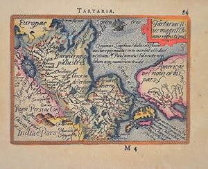
Tartariae stue magni Chami regni typus
Published by Artist: Ortelius Abraham ( - 1598 ) Antwerp ; issued in: Antwerp; - Abraham Ortelius (1527 - 1598) Antwerp comes from an Augsburg family and was born in Antwerp Spain where he lived throughout his life After thorough training he joined the Antwerp Guild of St Luke in 1547 as a card painter In 1554 he took over an antiquarian bookshop that mainly deals with the coloring distribution and publishing of maps Basically he is more of a publisher than a scholar And so he also made the acquaintance of another great man of his time Gerhard Mercator (1512-1594) who encouraged him to draw cards and to make maps of the most varied of countries His first cartographic work of his own is a large 8-sheet map of the world that appears in Antwerp in 1564 Thi, 1527
Seller: Antique Sommer& Sapunaru KG, M�nchen, Germany
Seller rating 4 out of 5 stars
Technic: Copper print, colorit: original colored, condition: Very good, size (in cm): 8 x 10,5; - Map shows total Russia with Japan and the Bering Sea. - additional information: From the pocket atlas; History: The East Slavs, emerged as a recognizable group in Europe between the 3rd and 8th centuries AD. founded and ruled by a Varangianwarrior elite and their descendants, the medieval state of Rus arose in the 9th century. In 988 it adopted Orthodox Christianity from the Byzantine Empire, beginning the synthesis of Byzantine and Slavic cultures that defined Russian culture for the next millennium. Rus ultimately disintegrated into a number of smaller states; most of the Rus' lands were overrun by the Mongol invasion and became tributaries of the nomadic Golden Horde in the 13th century. The Grand Duchy of Moscow gradually reunified the surrounding Russian principalities and achieved independence from the Golden Horde. By the 18th century, the nation had greatly expanded through conquest, annexation, and exploration to become the Russian Empire, which was the third largest empire in history, stretching from Poland on the west to Alaska on the east. In classical antiquity, the Pontic Steppe was known as Scythia. Beginning in the 8th century BC, Ancient Greek traders brought their civilization to the trade emporiums in Tanais and Phanagoria. Ancient Greek explorers, most notably Pytheas, even went as far as modern day Kaliningrad, on the Baltic Sea. Romans settled on the western part of the Caspian Sea, where their empire stretched towards the east. The establishment of the first East Slavic states in the 9th century coincided with the arrival of Varangians, the traders, warriors and settlers from the Baltic Sea region. Primarily they were Vikings of Scandinavian origin, who ventured along the waterways extending from the eastern Baltic to the Blackand Caspian Seas. In the 10th to 11th centuries Kievan Rus' became one of the largest and most prosperous states in Europe. Galicia-Volhynia was eventually assimilated by the Kingdom of Poland, while the Mongol-dominated Vladimir-Suzdal and Novgorod Republic, two regions on the periphery of Kiev, established the basis for the modern Russian nation. The most powerful state to eventually arise after the destruction of Kievan Rus' was the Grand Duchy of Moscow. Times remained difficult, with frequent Mongol-Tatar raids. Led by Prince Dmitry Donskoy of Moscow and helped by the Russian Orthodox Church, the united army of Russian principalities inflicted a milestone defeat on the Mongol-Tatars in the Battle of Kulikovo in 1380. Moscow gradually absorbed During his long reign, Ivan the Terrible nearly doubled the already large Russian territory by annexing the three Tatar khanates, Kazan and Astrakhan along the Volga River, and the Siberian Khanate in southwestern Siberia. However, the Tsardom was weakened by the long and unsuccessful Livonian War against the coalition of Poland, Lithuania, and Sweden for access to the Baltic coast and sea trade. The death of Ivan's sons marked the end of the ancient Rurik Dynasty in 1598. The Polish?Lithuanian Commonwealth occupied parts of Russia, including Moscow. In 1612, the Poles were forced to retreat by the Russian volunteer corps. The Romanov Dynasty acceded to the throne in 1613. Russia continued its territorial growth through the 17th century, which was the age of Cossacks. Cossacks were warriors organized into military communities, resembling pirates and pioneers of the New World. Under Peter the Great, Russia was proclaimed an Empire in 1721 and became recognized as a world power. Ruling from 1682 to 1725, Peter defeated Sweden in the Great Northern War, forcing it to cede West Karelia and Ingria, as well as Estland and Livland, securing Russia's access to the sea and sea trade. On the Baltic Sea, Peter founded a new capital called Saint Petersburg, later known as Russia's "window to Europe". Peter the Great's reforms brought considerable Western.
-
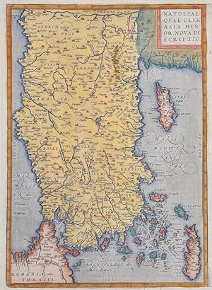
Natoliae, quae olim Asia minor, nova descriptio
Published by Artist: Ortelius Abraham ( - 1598 ) Antwerp ; issued in: Antwerp; - Abraham Ortelius (1527 - 1598) Antwerp comes from an Augsburg family and was born in Antwerp Spain where he lived throughout his life After thorough training he joined the Antwerp Guild of St Luke in 1547 as a card painter In 1554 he took over an antiquarian bookshop that mainly deals with the coloring distribution and publishing of maps Basically he is more of a publisher than a scholar And so he also made the acquaintance of another great man of his time Gerhard Mercator (1512-1594) who encouraged him to draw cards and to make maps of the most varied of countries His first cartographic work of his own is a large 8-sheet map of the world that appears in Antwerp in 1564 Thi, 1527
Seller: Antique Sommer& Sapunaru KG, M�nchen, Germany
Seller rating 4 out of 5 stars
Technic: Copper print, colorit: original colored, condition: Very good, size (in cm): 32 x 22,5 cm; - Map shows the whole of Turkey with the islands of Cyprus, Crete, Rhodes, Samos and many more.; History: The area of today's Turkey has been populated since the Paleolithic. The name of the Turks comes from Central Asia. The immigrants from whom Turkey got its name were the Oghusen and came from the area around the Aral Sea. The Turkish settlement of Anatolia began with the arrival of the Seljuks in the 11th century AD. Around 1299, Osman I, Gazi (1259?1326) founded the Ottoman dynasty named after him, from which the name of the Ottoman Empire (also called the Turkish Empire) ) derives. After the conquest of Constantinople in 1453, the Ottomans ruled over large parts of the Middle East, North Africa, the Crimea, the Caucasus and the Balkans. After the expansion of the Ottoman Empire into Europe was brought to a standstill near Vienna and the Ottoman army was defeated there on Kahlenberg in 1683, the empire was pushed back further and further from its European territories to the tip west of the Marmara Sea, between Istanbul and Edirne. The national movements that emerged from the 19th century onwards led to a gradual fragmentation of the empire, the occupation of Turkish North Africa by European powers and finally the defeat in the First World War resulted in its ultimate decline.
-
Regionis, Biturigum exactiss: descriptio per d. 10 annem calamaeum. / Limaniae Topographia, Gabriele symeoneo auct.
Published by Artist: Ortelius Abraham ( - 1598 ) Antwerp ; issued in: Antwerp; - Abraham Ortelius (1527 - 1598) Antwerp comes from an Augsburg family and was born in Antwerp Spain where he lived throughout his life After thorough training he joined the Antwerp Guild of St Luke in 1547 as a card painter In 1554 he took over an antiquarian bookshop that mainly deals with the coloring distribution and publishing of maps Basically he is more of a publisher than a scholar And so he also made the acquaintance of another great man of his time Gerhard Mercator (1512-1594) who encouraged him to draw cards and to make maps of the most varied of countries His first cartographic work of his own is a large 8-sheet map of the world that appears in Antwerp in 1564 Thi, 1527
Seller: Antique Sommer& Sapunaru KG, M�nchen, Germany
Seller rating 4 out of 5 stars
Technic: Copper print, colorit: original colored, condition: Perfect condition, size (in cm): 31 x 48 cm; - Two maps on one sheet, showing the area of Bourges in Aquitania in France. The right map is showing the river Allier in Limagne with the city Clermont-Ferrand in the center of France, region Auvergne-Rh�ne-Alpes. - additional information: Latin edition of Ortelius'Theatrum,; History: It is estimated that today's France was settled about 48,000 years ago. Important rock paintings from the Paleolithic period have been preserved in the Lascaux cave From 600 BC Chr. Phoenician and Greek traders founded bases on the Mediterranean coast, while Celts settled from the northwest the country that was later called by the Romans as Gaul. The French Middle Ages were marked by the rise of kingship in the constant struggle against the independence of the nobility and the secular violence of the monasteries and religious orders. Starting from today's �le-de-France, the Capetinians enforced the idea of a unitary state, which was underpinned by participation in various crusades. The Normans invaded Normandy repeatedly, hence its name; in 1066 they conquered England. A long series of armed conflicts with England began under Louis VII after Ludwig's divorced wife Eleonore von Poitou and Aquitaine married Heinrich Plantagenet in 1152 and thus about half of France's territory fell to England. Philip II August, together with the Hohenstaufen family, largely displaced England from France until 1299; the English king Henry III Ludwig IX. recognize as suzerain. From 1226 France became an inheritance monarchy; in 1250 Ludwig IX was one of the most powerful rulers in the West. In the 17th and 18th centuries, France held European leadership and supremacy. The political and cultural charisma was significant: The court of Louis XIV became the model for absolutist states throughout Europe and the French Revolution with the declaration of human and civil rights, together with occupations by Napoleon Bonaparte, started in many countries the time and again Setbacks interrupted development towards democracy.
-
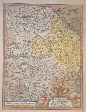
Basiliensis territorii des criptio nova, Auctore Sebastiano Munstero.
Published by Artist: Ortelius Abraham ( - 1598 ) Antwerp ; issued in: Antwerp; - Abraham Ortelius (1527 - 1598) Antwerp comes from an Augsburg family and was born in Antwerp Spain where he lived throughout his life After thorough training he joined the Antwerp Guild of St Luke in 1547 as a card painter In 1554 he took over an antiquarian bookshop that mainly deals with the coloring distribution and publishing of maps Basically he is more of a publisher than a scholar And so he also made the acquaintance of another great man of his time Gerhard Mercator (1512-1594) who encouraged him to draw cards and to make maps of the most varied of countries His first cartographic work of his own is a large 8-sheet map of the world that appears in Antwerp in 1564 Thi, 1527
Seller: Antique Sommer& Sapunaru KG, M�nchen, Germany
Seller rating 4 out of 5 stars
Technic: Copper print, colorit: original colored, condition: Right Margin enlarged, size (in cm): 32 x 24 cm; - Map shows the area around Basel am Rhein with Freiburg and many more towns. Such as Bremgargten, Laufenburg and Aarburg in the canton of Aargau, Masm�nster and Metzeral in Alsace, a mileage indicator and a title cartouche. - additional information: from "Theatrum Orbis Terrarum"; History: Since 1848, the Swiss Confederation has been a federal state of relatively autonomous cantons, some of which have a history of confederacy that goes back more than 700 years, putting them among the world's oldest surviving republics. The early history of the region is tied to that of Alpine culture. Switzerland was inhabited by Gauls and Raetians, and it came under Roman rule in the 1st century BC. Gallo-Roman culture was amalgamated with Germanic influence during Late Antiquity, with the eastern part of Switzerland becoming Alemannic territory. The area of Switzerland was incorporated into the Frankish Empire in the 6th century. In the high medieval period, the eastern part became part of the Duchy of Swabia within the Holy Roman Empire while the western part was part of Burgundy.
-
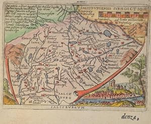
Salisburgum
Published by Artist: Ortelius Abraham ( - 1598 ) Antwerp ; issued in: Antwerp; - Abraham Ortelius (1527 - 1598) Antwerp comes from an Augsburg family and was born in Antwerp Spain where he lived throughout his life After thorough training he joined the Antwerp Guild of St Luke in 1547 as a card painter In 1554 he took over an antiquarian bookshop that mainly deals with the coloring distribution and publishing of maps Basically he is more of a publisher than a scholar And so he also made the acquaintance of another great man of his time Gerhard Mercator (1512-1594) who encouraged him to draw cards and to make maps of the most varied of countries His first cartographic work of his own is a large 8-sheet map of the world that appears in Antwerp in 1564 Thi, 1527
Seller: Antique Sommer& Sapunaru KG, M�nchen, Germany
Seller rating 4 out of 5 stars
Technic: Copper print, colorit: colored, condition: Perfect condition, size (in cm): 7,5 x 10,5 cm; - Map shows a map of the area around the city of Salzburg with Chiemsee, the Zillertal, and an overall view of Salzburg.; History: The territory of the town has been continuously inhabited since the Neolithic period until today. Since the Battle of M�hldorf in 1322, the archbishopric was at enmity with the motherland Bavaria. As a result, Salzburg became an independent archbishopric in the Roman-German Empire. The economic prosperity of the city in the 15th century led to a self-confident bourgeoisie with increasing rights and duties. Archbishop Leonhard von Keutschach, who was economically very successful, ended this autonomy by force. A few years after Martin Luther's posting of the theses, the majority of the town's population was close to Protestantism; the unbending Protestants were then all expelled from the country by 1590. In 1525, rebellious squires and peasants laid siege to the fortress of Hohensalzburg, where Archbishop Matth�us Lang von Wellenburg had entrenched himself. Around 1600, the archdiocese was one of the richest principalities in the Roman-German Empire thanks to salt and gold mining. Paris von Lodron succeeded in keeping Salzburg out of the Thirty Years' War (1618-1648) through a clever policy of neutrality. The city was developed into one of the best fortified cities in Europe. In 1803, by order of Napoleon Bonaparte, Salzburg became a secularized electorate. In 1805, together with Berchtesgaden, it was annexed to the new Empire of Austria, and in 1810, it was reincorporated into the Kingdom of Bavaria. In 1816, with the Treaty of Munich, most of the province of Salzburg again fell to the Austrian Empire and thus under Habsburg rule.
-
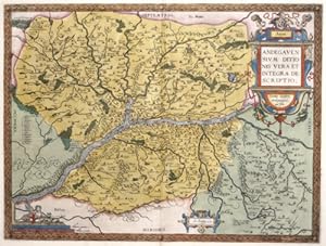
Anjou / Andegavensium Ditionis Vera et Integra Descriptio
Published by Artist: Ortelius Abraham ( - 1598 ) Antwerp ; issued in: Antwerp; - Abraham Ortelius (1527 - 1598) Antwerp comes from an Augsburg family and was born in Antwerp Spain where he lived throughout his life After thorough training he joined the Antwerp Guild of St Luke in 1547 as a card painter In 1554 he took over an antiquarian bookshop that mainly deals with the coloring distribution and publishing of maps Basically he is more of a publisher than a scholar And so he also made the acquaintance of another great man of his time Gerhard Mercator (1512-1594) who encouraged him to draw cards and to make maps of the most varied of countries His first cartographic work of his own is a large 8-sheet map of the world that appears in Antwerp in 1564 Thi, 1527
Seller: Antique Sommer& Sapunaru KG, M�nchen, Germany
Seller rating 4 out of 5 stars
Technic: Copper print, colorit: original colored, condition: Perfect condition, size (in cm): 35,5 x 47; - Map shows the province of Anjou with the city of Angers on the Loire, a title cartouche and a mileage indicator cartouche. - additional information: French edition of Ortelius'Theatrum,; History: It is estimated that today's France was settled about 48,000 years ago. Important rock paintings from the Paleolithic period have been preserved in the Lascaux cave From 600 BC Chr. Phoenician and Greek traders founded bases on the Mediterranean coast, while Celts settled from the northwest the country that was later called by the Romans as Gaul. The French Middle Ages were marked by the rise of kingship in the constant struggle against the independence of the nobility and the secular violence of the monasteries and religious orders. Starting from today's �le-de-France, the Capetinians enforced the idea of a unitary state, which was underpinned by participation in various crusades. The Normans invaded Normandy repeatedly, hence its name; in 1066 they conquered England. A long series of armed conflicts with England began under Louis VII after Ludwig's divorced wife Eleonore von Poitou and Aquitaine married Heinrich Plantagenet in 1152 and thus about half of France's territory fell to England. Philip II August, together with the Hohenstaufen family, largely displaced England from France until 1299; the English king Henry III Ludwig IX. recognize as suzerain. From 1226 France became an inheritance monarchy; in 1250 Ludwig IX was one of the most powerful rulers in the West. In the 17th and 18th centuries, France held European leadership and supremacy. The political and cultural charisma was significant: The court of Louis XIV became the model for absolutist states throughout Europe and the French Revolution with the declaration of human and civil rights, together with occupations by Napoleon Bonaparte, started in many countries the time and again Setbacks interrupted development towards democracy.
-
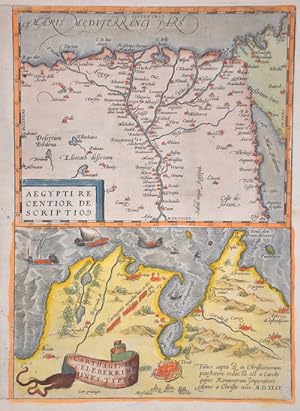
Aegypti recentior descriptio/ Carthaginis celeberrini sinus typus
Published by Artist: Ortelius Abraham ( - 1598 ) Antwerp ; issued in: Antwerp; - Abraham Ortelius (1527 - 1598) Antwerp comes from an Augsburg family and was born in Antwerp Spain where he lived throughout his life After thorough training he joined the Antwerp Guild of St Luke in 1547 as a card painter In 1554 he took over an antiquarian bookshop that mainly deals with the coloring distribution and publishing of maps Basically he is more of a publisher than a scholar And so he also made the acquaintance of another great man of his time Gerhard Mercator (1512-1594) who encouraged him to draw cards and to make maps of the most varied of countries His first cartographic work of his own is a large 8-sheet map of the world that appears in Antwerp in 1564 Thi, 1527
Seller: Antique Sommer& Sapunaru KG, M�nchen, Germany
Seller rating 4 out of 5 stars
Technic: Copper print, colorit: original colored, condition: Very good, size (in cm): 32 x 23; - Map shows Egypt and the bay of Tunis in Tunesia - additional information: 2 maps at one sheet; History: The ancient Egyptian country name Kemet means "Black Land" and refers to the fertile soil of the Nile Valley in contrast to the "Red Land" of the neighboring deserts. The European terms Egypt, engl. Egypt comes from the Latin Aegyptus and thus ultimately from the ancient Greek Aigypto. The Copts claim to be the direct descendants of the ancient Egyptian pharaohs. From their name came the Greek Aigyptos, which became Egypt in German. Islamic Arabs conquered the Nile valley around 640; From now on Egypt was dominated by changing power centers - Damascus, Baghdad, Cairo. Under the Umayyads (661?750), Arab tribes settled in the fertile plains and from then on determined the cultural appearance of Egypt. With the coming to power of Saladin, the founder of the Ayyubid dynasty (1171?1249), Cairo became the center of Muslim resistance to the Christian crusades. Around 1250 the palace guard, which was made up of Mamluks, originally mostly Turkish military slaves, rose and took over. At the end of the 13th century, the Mamluks destroyed the last Crusader states on Asian soil. Even after Egypt was conquered by the Ottoman Empire in 1517, administration remained in their hands. The economic decline resulting from the discovery of the sea route to India (1498) made Egypt one of the poorest provinces of the Ottoman Empire. It was not until the landing of the French expeditionary force under Napoleon Bonaparte in 1798 that the Ottoman rule ended. When the French had to abandon their Oriental campaign after the British Admiral Nelson won at Abukir in the same year, the Albanian officer Muhammad Ali Pasha used the situation to seize power (1805?1849). He and his successors were able to achieve a certain independence under Ottoman rule, pursued an expansionary policy and initiated the history of modern Egypt.
-
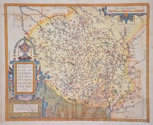
Burgundiae inferioris, quae ducatus nomine censetur, des. 1584.
Published by Artist: Ortelius Abraham ( - 1598 ) Antwerp ; issued in: Antwerp; - Abraham Ortelius (1527 - 1598) Antwerp comes from an Augsburg family and was born in Antwerp Spain where he lived throughout his life After thorough training he joined the Antwerp Guild of St Luke in 1547 as a card painter In 1554 he took over an antiquarian bookshop that mainly deals with the coloring distribution and publishing of maps Basically he is more of a publisher than a scholar And so he also made the acquaintance of another great man of his time Gerhard Mercator (1512-1594) who encouraged him to draw cards and to make maps of the most varied of countries His first cartographic work of his own is a large 8-sheet map of the world that appears in Antwerp in 1564 Thi, 1527
Seller: Antique Sommer& Sapunaru KG, M�nchen, Germany
Seller rating 4 out of 5 stars
Technic: Copper print, colorit: original colored, condition: Some restorations along the orig. outline colours, size (in cm): 37,5 x 45,5 cm; - Very decorative map showing the Duchy of Burgundy in France with a splendid title cartouche and a mileage scale cartouche. The detailed map shows many places such as Avalon, Auttun, Chalons, Beaulne, Chastillon, Noyers, Dijon, Saulieu, Ravi�res, Montbard, etc. The reverse with a French description. - additional information: from "Theatrum Orbis Terrarum", italian edition; History: The present region was already inhabited by people in the Paleolithic Age. The Duchy of Burgundy was ruled by a side line of the French royal house, the Capetians, from 1032 to 1361. It passed to Philip of Valois in 1363, who founded the House of Burgundy as a collateral line of the French royal house of Valois. The duchy was dissolved after the French Revolution in the course of the division of the state into departments in 1790; with it disappeared the name Burgundy for a political-administrative unit.
-
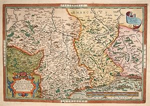
Saxoniae, Misniae, Thuringiae, nova exactissimao descriptio
Published by Artist: Ortelius Abraham ( - 1598 ) Antwerp ; issued in: Antwerp; - Abraham Ortelius (1527 - 1598) Antwerp comes from an Augsburg family and was born in Antwerp Spain where he lived throughout his life After thorough training he joined the Antwerp Guild of St Luke in 1547 as a card painter In 1554 he took over an antiquarian bookshop that mainly deals with the coloring distribution and publishing of maps Basically he is more of a publisher than a scholar And so he also made the acquaintance of another great man of his time Gerhard Mercator (1512-1594) who encouraged him to draw cards and to make maps of the most varied of countries His first cartographic work of his own is a large 8-sheet map of the world that appears in Antwerp in 1564 Thi, 1527
Seller: Antique Sommer& Sapunaru KG, M�nchen, Germany
Seller rating 4 out of 5 stars
Technic: Copper print, colorit: colored, condition: Perfect condition, size (in cm): 34,5 x 51 cm; - Map shows Saxony with splendid scrollwork cartouche and a mileage scale. - additional information: From the atlas " Theatrum Orbis Terrarum", latin edition; History: Saxony-Wittenberg, in modern Saxony-Anhalt, became subject to the margravate of Meissen, ruled by the Wettin dynasty in 1423. This established a new and powerful state, occupying large portions of the present Free State of Saxony, Thuringia, Saxony-Anhalt and Bavaria (Coburg and its environs). Although the centre of this state was far to the southeast of the former Saxony, it came to be referred to as Upper Saxony and then simply Saxony, while the former Saxon territories were now known as Lower Saxony. In 1485, Saxony was split. A collateral line of the Wettin princes received what later became Thuringia and founded several small states there (see Ernestine duchies). The remaining Saxon state became still more powerful and was known in the 18th century for its cultural achievements, although it was politically weaker than Prussia and Austria, states which oppressed Saxony from the north and south, respectively.
-

Mansfeldiae Comitatus Descriptio. Auctore Tilemanno Stella Sig.
Published by Artist: Ortelius Abraham ( - 1598 ) Antwerp ; issued in: Antwerp; - Abraham Ortelius (1527 - 1598) Antwerp comes from an Augsburg family and was born in Antwerp Spain where he lived throughout his life After thorough training he joined the Antwerp Guild of St Luke in 1547 as a card painter In 1554 he took over an antiquarian bookshop that mainly deals with the coloring distribution and publishing of maps Basically he is more of a publisher than a scholar And so he also made the acquaintance of another great man of his time Gerhard Mercator (1512-1594) who encouraged him to draw cards and to make maps of the most varied of countries His first cartographic work of his own is a large 8-sheet map of the world that appears in Antwerp in 1564 Thi, 1527
Seller: Antique Sommer& Sapunaru KG, M�nchen, Germany
Seller rating 4 out of 5 stars
Technic: Copper print, colorit: colored, condition: Perfect condition, size (in cm): 37 x 43 cm; - Mansfeld County is shown on the map of Tilmann Stella. Detailed map with many places, rivers, forests, etc. Shows the area between Halle a. d. Saale, Aschersleben, Walkenried and Heldrungen with Mansfeld in the center.; History: The area of today's state of Saxony-Anhalt was one of the cultural focal points in the German-speaking area in the early Middle Ages. Today's state capital Magdeburg was at that time one of the political centers in the Holy Roman Empire of the German Nation. The well-preserved architectural monuments from the Romanesque and Gothic periods, such as the cathedrals in Magdeburg and Halberstadt, the old town of Quedlinburg and many castles and churches, testify to the earlier importance of the entire region. The state was created in July 1947 through the unification of the Free State of Anhalt with the Prussian provinces of Magdeburg and Halle-Merseburg, which the Free State of Prussia had created in April 1944 by dividing its province of Saxony.
-
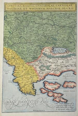
Goritiae, Karstii, Chaczeolae, Carniolae, Istriae, et Vindorum marchae descrip
Published by Artist: Ortelius Abraham ( - 1598 ) Antwerp ; issued in: Antwerp; - Abraham Ortelius (1527 - 1598) Antwerp comes from an Augsburg family and was born in Antwerp Spain where he lived throughout his life After thorough training he joined the Antwerp Guild of St Luke in 1547 as a card painter In 1554 he took over an antiquarian bookshop that mainly deals with the coloring distribution and publishing of maps Basically he is more of a publisher than a scholar And so he also made the acquaintance of another great man of his time Gerhard Mercator (1512-1594) who encouraged him to draw cards and to make maps of the most varied of countries His first cartographic work of his own is a large 8-sheet map of the world that appears in Antwerp in 1564 Thi, 1527
Seller: Antique Sommer& Sapunaru KG, M�nchen, Germany
Seller rating 4 out of 5 stars
Technic: Copper print, colorit: original colored, condition: Very good, size (in cm): 34 x 23 cm; - Map shows Istria, Slovenia, northern Dalmatia and the southwest of Austria.; History: In the historical sense, Eastern Europe refers to Ukraine, the European part of Russia, Belarus and the Republic of Moldova. Occasionally, the Caucasian countries of Georgia, Armenia and, conditionally, Azerbaijan are also seen as part of Eastern Europe. By Christian Giordano and other scholars, one of the six historical regions of Europe is called "Eastern Europe." The Eastern European countries are historically and culturally largely influenced by the Orthodox Church (Islamic Azerbaijan excepted) and were - in contrast to the Ottoman-dominated Balkans - under the rule of the Russian Empire. Like the Balkan countries, the countries of Eastern Europe were for a long time backward agricultural states (cf.: Intermediate Europe) and had no or only a limited share in the social developments of the Renaissance, Reformation and Enlightenment of the Western world.
-
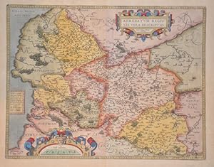
Atrebatum Regionis vera descriptio.
Published by Artist: Ortelius Abraham ( - 1598 ) Antwerp ; issued in: Antwerp; - Abraham Ortelius (1527 - 1598) Antwerp comes from an Augsburg family and was born in Antwerp Spain where he lived throughout his life After thorough training he joined the Antwerp Guild of St Luke in 1547 as a card painter In 1554 he took over an antiquarian bookshop that mainly deals with the coloring distribution and publishing of maps Basically he is more of a publisher than a scholar And so he also made the acquaintance of another great man of his time Gerhard Mercator (1512-1594) who encouraged him to draw cards and to make maps of the most varied of countries His first cartographic work of his own is a large 8-sheet map of the world that appears in Antwerp in 1564 Thi, 1527
Seller: Antique Sommer& Sapunaru KG, M�nchen, Germany
Seller rating 4 out of 5 stars
Technic: Copper print, colorit: original colored, condition: Perfect condition, size (in cm): 38 x 49 cm; - Map shows the historical region of Artois, located in the Pas-de-Calais department in France. Magnificent title cartouche at the top right and a mile marker cartouche at the bottom left. The dedication cartouche in the middle on the left side identifies this sheet as van den Broecke 74. - additional information: from "Theatrum Orbis Terrarum", latin edition; History: Pas-de-Calais is one of the 83 departments created in 1790 during the French Revolution in application of the law of December 1789. It was created by merging Artois and parts of Picardy, the Boulonnais and part of the Ponthieu.
-
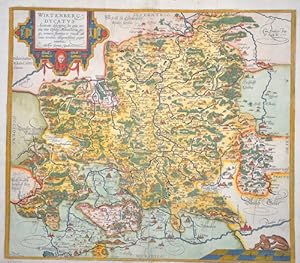
Wirtenberg. Ducatus
Published by Artist: Ortelius Abraham ( - 1598 ) Antwerp ; issued in: Antwerp; - Abraham Ortelius (1527 - 1598) Antwerp comes from an Augsburg family and was born in Antwerp Spain where he lived throughout his life After thorough training he joined the Antwerp Guild of St Luke in 1547 as a card painter In 1554 he took over an antiquarian bookshop that mainly deals with the coloring distribution and publishing of maps Basically he is more of a publisher than a scholar And so he also made the acquaintance of another great man of his time Gerhard Mercator (1512-1594) who encouraged him to draw cards and to make maps of the most varied of countries His first cartographic work of his own is a large 8-sheet map of the world that appears in Antwerp in 1564 Thi, 1527
Seller: Antique Sommer& Sapunaru KG, M�nchen, Germany
Seller rating 4 out of 5 stars
Technic: Copper print, colorit: original colored, condition: Some restoration at centerfold, size (in cm): 38,5 x 44 cm; - Map shows W�rttemberg with Stuttgart, Pforzheim, Rotenburg Castle, Blaubeuren, Ulm, Schw�bisch Hall and many more. Furthermore, a title cartouche and a mileage indicator with two monkeys.; History: Baden-Wuertemberg is a state in southwest Germany, east of the Rhine, which forms the border with France. It is is formed from the historical territories of Baden, Prussian Hohenzollern, and W�rttemberg, and also parts of Swabia. Baden W�rtemberg was only founded in 1952 by the merger of the states of W�rttemberg-Baden, Baden and W�rttemberg-Hohenzollern. Today the most populous city of Baden-W�rttemberg is the state capital Stuttgart, followed by Karlsruhe and Mannheim. Other major cities are Freiburg im Breisgau, Heidelberg, Ulm, Heilbronn, Pforzheim and Reutlingen. The early modern period was marked by the Reformation and the expansion efforts of the emerging states of Austria, Prussia, France and Sweden. Conflicts such as the Peasant War, the Thirty Years' War and the Palatinate War of Succession resulted from these. One of the focal points of the fighting, with corresponding consequences for the population and the economy, was in what is today Baden-W�rttemberg, which remained extremely fragmented territorially. At the beginning of the 19th century, around 300 states still had territorial rights in what is now Baden-W�rttemberg, but their number was reduced to four after the dissolution of the Old Empire. The Kingdom of W�rttemberg and the Grand Duchy of Baden were among the winners of the coalition wars. The two principalities of Hohenzollern-Sigmaringen and Hohenzollern-Hechingen survived mediatization due to their special relationship with Napol�on. In 1849, the Baden Revolution was put down by Prussian intervention forces, the Baden army was dissolved and rebuilt under Prussian leadership. In 1850 the two Hohenzollern states became the Prussian province of Hohenzollernsche Lande. With the new formation of the tribal duchies, the southern areas of what is now the state of Baden-W�rttemberg belonged to the Duchy of Swabia until the end of the High Middle Ages, the northern areas were located with the Duchy of Franconia.
-
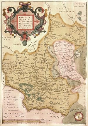
Monasterienesis et Osnaburgensis episcopatus descriptio
Published by Artist: Ortelius Abraham ( - 1598 ) Antwerp ; issued in: Antwerp; - Abraham Ortelius (1527 - 1598) Antwerp comes from an Augsburg family and was born in Antwerp Spain where he lived throughout his life After thorough training he joined the Antwerp Guild of St Luke in 1547 as a card painter In 1554 he took over an antiquarian bookshop that mainly deals with the coloring distribution and publishing of maps Basically he is more of a publisher than a scholar And so he also made the acquaintance of another great man of his time Gerhard Mercator (1512-1594) who encouraged him to draw cards and to make maps of the most varied of countries His first cartographic work of his own is a large 8-sheet map of the world that appears in Antwerp in 1564 Thi, 1527
Seller: Antique Sommer& Sapunaru KG, M�nchen, Germany
Seller rating 4 out of 5 stars
Technic: Copper print, colorit: original colored, condition: Very good, size (in cm): 36 x 24,5; - Map shows partly Nordrhein- Westfalen with the city of Munster - additional information: Beautiful edition, hightened with gold, rare; History: The first written account of the area was by its conqueror, Julius Caesar, the territories west of the Rhine were occupied by the Eburones and east of the Rhine he reported the Ubii (across from Cologne) and the Sugambri to their north. The Ubii and some other Germanic tribes such as the Cugerni were later settled on the west side of the Rhine in the Roman province of Germania Inferior. Julius Caesar conquered the tribes on the left bank, and Augustus established numerous fortified posts on the Rhine, but the Romans never succeeded in gaining a firm footing on the right bank, where the Sugambri neighboured several other tribes including the Tencteri and Usipetes. North of the Sigambri and the Rhine region were the Bructeri. and by the end of the fifth century had conquered all the lands that had formerly been under Roman influence. By the eighth century, the Frankish dominion was firmly established in western Germany and northern Gaul, but at the same time, to the north, Westphalia was being taken over by Saxons pushing south. As the central power of the Holy Roman Emperor weakened, the Rhineland split into numerous small, independent, separate vicissitudes and special chronicles. Prussia first set foot on the Rhine in 1609 by the occupation of the Duchy of Cleves and about a century later Upper Guelders and Moers also became Prussian. At the peace of Basel in 1795, the whole of the left bank of the Rhine was resigned to France, and in 1806, the Rhenish princes all joined the Confederation of the Rhine. After the Congress of Vienna, Prussia was awarded the entire Rhineland, which included the Grand Duchy of Berg, the ecclesiastic electorates of Trier and Cologne, the free cities of Aachen and Cologne, and nearly a hundred small lordships and abbeys. The Prussian Rhine province was formed in 1822 and Prussia had the tact to leave them in undisturbed possession of the liberal institutions to which they had become accustomed under the republican rule of the French. In 1920, the districts of Eupen and Malmedy were transferred to Belgium (see German-speaking Community of Belgium). After the Congress of Vienna, the Kingdom of Prussia received a large amount of territory in the Westphalian region and created the province of Westphalia in 1815. The northernmost portions of the former kingdom, including the town of Osnabr�ck, had become part of the states of Hanover and Oldenburg.
-
Moraviae Qua Olim Marcomannorum Sedes, Corographia , A.D.Paulo Fabritio Medico et Mathematico Descripta.
Published by Artist: Ortelius Abraham ( - 1598 ) Antwerp ; issued in: Antwerp; - Abraham Ortelius (1527 - 1598) Antwerp comes from an Augsburg family and was born in Antwerp Spain where he lived throughout his life After thorough training he joined the Antwerp Guild of St Luke in 1547 as a card painter In 1554 he took over an antiquarian bookshop that mainly deals with the coloring distribution and publishing of maps Basically he is more of a publisher than a scholar And so he also made the acquaintance of another great man of his time Gerhard Mercator (1512-1594) who encouraged him to draw cards and to make maps of the most varied of countries His first cartographic work of his own is a large 8-sheet map of the world that appears in Antwerp in 1564 Thi, 1527
Seller: Antique Sommer& Sapunaru KG, M�nchen, Germany
Seller rating 4 out of 5 stars
Technic: Copper print, colorit: original colored, condition: Very good, size (in cm): 36 x 47; - Map shows total Moravia; History: Moravia developed on both sides of the Amber Road in prehistoric times. Around 60 BC The Celtic Boier withdrew from the area and were replaced by Germanic Marcomanni and Quadi, who moved on to the Alpine foothills around 550 AD together with the Rugians. Today's Moravia was still independent for a short time after the devastating defeat against the Hungarians and came under Bohemian sovereignty around 955. After being ruled briefly by Poland's ruler Boleslaw Chrobry from 999 to 1019, Moravia finally became Bohemian in 1031. The Principality and later Kingdom of Bohemia was ruled by the P_emyslid dynasty until it died out in the male line in 1305. Moravian history has been parallel to the history of Bohemia almost continuously since 1031. After the P_emyslids died out, the kingdom was ruled by the House of Luxembourg until 1437. The P_emyslid and Luxembourg dynasties also included the Moravian margraves, so u. a. the later King Ottokar II. P_emysl, the later King and Emperor Charles IV. and his nephew, the largely independent Margrave Jobst of Moravia. In 1469, the Hungarian King Matthias Corvinus advanced with his armed forces to Moravia to overthrow his father-in-law Georg von Podiebrad, whose daughter Katharina he married in 1461, as King of Bohemia. Matthias could never conquer the actual Bohemia, his rule only extended over the Bohemian neighboring countries Moravia, Silesia (with Breslau), Upper and Lower Lusatia. Nevertheless, he called himself King of Bohemia from 1469 and was crowned in 1471. As early as 1526, one of the first communities of property of the radical Reformation Anabaptist movement was formed around Balthasar Hubmaier in the Nikolsburg area. The impending dissolution of the Anabaptist community after the execution of Hubmaier in 1528 was prevented by Jakob Hutter, who came from Tyrol. The Anabaptists were also called the Hutterite Brothers after him. During the Catholic Reform and Recatholization, which were carried out by the Jesuits in particular, many churches were able to be consecrated Catholic again. The capital of Moravia and the seat of the margraves was the centrally located Olomouc from the rule of the Luxembourgers until 1641. After that, the larger Brno became the capital of the country. As the margraviate of Moravia, it formed its own crown land in the Austrian Empire and, from 1867, in the western half of Austria-Hungary. After Hungary left the empire and the real union Austria-Hungary was created in 1867, the remaining crown lands were officially referred to as Cisleithania or the kingdoms and countries represented in the Imperial Council.
-
Austriae descript
Published by Artist: Ortelius Abraham ( - 1598 ) Antwerp ; issued in: Antwerp; - Abraham Ortelius (1527 - 1598) Antwerp comes from an Augsburg family and was born in Antwerp Spain where he lived throughout his life After thorough training he joined the Antwerp Guild of St Luke in 1547 as a card painter In 1554 he took over an antiquarian bookshop that mainly deals with the coloring distribution and publishing of maps Basically he is more of a publisher than a scholar And so he also made the acquaintance of another great man of his time Gerhard Mercator (1512-1594) who encouraged him to draw cards and to make maps of the most varied of countries His first cartographic work of his own is a large 8-sheet map of the world that appears in Antwerp in 1564 Thi, 1527
Seller: Antique Sommer& Sapunaru KG, M�nchen, Germany
Seller rating 4 out of 5 stars
Technic: Copper print, colorit: original colored, condition: Very good, size (in cm): 35 x 48; - Map shows the total eastern part of Austria; History: The name Austria is first handed down in its Old High German form Ostarrichi from the year 996. The Latin form Austria was also used. In 1156 Austria became an independent duchy in the Holy Roman Empire. After the Babenbergs died out in 1246, the House of Habsburg prevailed in the struggle for rule in Austria. The area designated as Austria later included the entire Habsburg Monarchy and later the Austrian Empire, which was constituted in 1804, and the Austrian half of the Austro-Hungarian Dual Monarchy established in 1867. The present republic came into being in 1918.
-
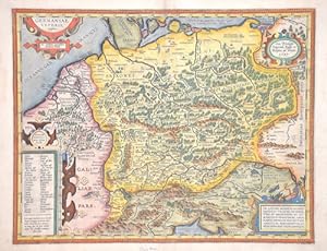
Germaniae Veteris, typus
Published by Artist: Ortelius Abraham ( - 1598 ) Antwerp ; issued in: Antwerp; - Abraham Ortelius (1527 - 1598) Antwerp comes from an Augsburg family and was born in Antwerp Spain where he lived throughout his life After thorough training he joined the Antwerp Guild of St Luke in 1547 as a card painter In 1554 he took over an antiquarian bookshop that mainly deals with the coloring distribution and publishing of maps Basically he is more of a publisher than a scholar And so he also made the acquaintance of another great man of his time Gerhard Mercator (1512-1594) who encouraged him to draw cards and to make maps of the most varied of countries His first cartographic work of his own is a large 8-sheet map of the world that appears in Antwerp in 1564 Thi, 1527
Seller: Antique Sommer& Sapunaru KG, M�nchen, Germany
Seller rating 4 out of 5 stars
Technic: Copper print, colorit: original colored, condition: Perfect condition, size (in cm): 36,5 x 46,5 cm; - Splendid map showing the whole of Germany with 4 scrollwork cartouches. From the Parergon. The Parergon maps first appeared as a supplement to Ortelius' main work Theatrum Orbis Terrarum in 1579 with 3 maps. In the following years further maps were added and the Parergon became an atlas in its own right. Back with German text. - additional information: German edition; History: The concept of Germany as a distinct region in central Europe can be traced to Roman commander Julius Caesar, who referred to the unconquered area east of the Rhine as Germania, thus distinguishing it from Gaul (France), which he had conquered. In the High Middle Ages, the regional dukes, princes and bishops gained power at the expense of the emperors. Martin Luther led the Protestant Reformationagainst the Catholic Church after 1517, as the northern states became Protestant, while the southern states remained Catholic. The two parts of the Holy Roman Empire clashed in the Thirty Years' War (1618?1648). 1648 marked the effective end of the Holy Roman Empire and the beginning of the modern nation-state system, with Germany divided into numerous independent states, such as Prussia, Bavaria and Saxony.
-
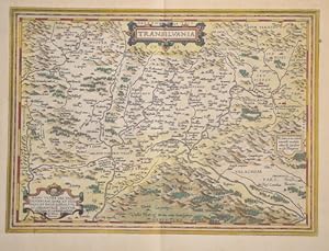
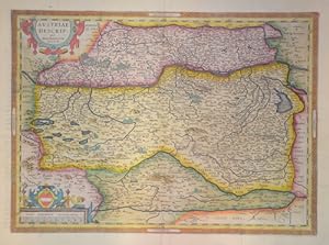
Transilvania
Published by Artist: Ortelius Abraham ( - 1598 ) Antwerp ; issued in: Antwerp; - Abraham Ortelius (1527 - 1598) Antwerp comes from an Augsburg family and was born in Antwerp Spain where he lived throughout his life After thorough training he joined the Antwerp Guild of St Luke in 1547 as a card painter In 1554 he took over an antiquarian bookshop that mainly deals with the coloring distribution and publishing of maps Basically he is more of a publisher than a scholar And so he also made the acquaintance of another great man of his time Gerhard Mercator (1512-1594) who encouraged him to draw cards and to make maps of the most varied of countries His first cartographic work of his own is a large 8-sheet map of the world that appears in Antwerp in 1564 Thi, 1527
Seller: Antique Sommer& Sapunaru KG, M�nchen, Germany
Seller rating 4 out of 5 stars
Technic: Copper print, colorit: original colored, condition: Perfect condition, size (in cm): 33 x 46 cm; - Map shows total Transilvania with parts of Walachia.Detailed with all cities, forests and mountains and 3 decorative cartouches.
-
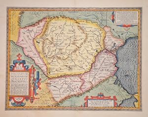
Daciarum, Moesiarum que, vetus descriptio
Published by Artist: Ortelius Abraham ( - 1598 ) Antwerp ; issued in: Antwerp; - Abraham Ortelius (1527 - 1598) Antwerp comes from an Augsburg family and was born in Antwerp Spain where he lived throughout his life After thorough training he joined the Antwerp Guild of St Luke in 1547 as a card painter In 1554 he took over an antiquarian bookshop that mainly deals with the coloring distribution and publishing of maps Basically he is more of a publisher than a scholar And so he also made the acquaintance of another great man of his time Gerhard Mercator (1512-1594) who encouraged him to draw cards and to make maps of the most varied of countries His first cartographic work of his own is a large 8-sheet map of the world that appears in Antwerp in 1564 Thi, 1527
Seller: Antique Sommer& Sapunaru KG, M�nchen, Germany
Seller rating 4 out of 5 stars
Technic: Copper print, colorit: original colored, condition: Very good, size (in cm): 35 x 46; - Map shows Romania with its neighbour countries.; History: Romania is a sovereign state located at the crossroads of Central, Eastern, and Southeastern Europe. It borders the Black Sea, Bulgaria, Ukraine, Hungary, Serbia, and Moldova. Modern Romania was formed in 1859 through a personal union of the Danubian Principalities of Moldavia and Wallachia. Prior to the Roman conquest of Dacia, the territories between the Danube and Dniester rivers were inhabited by various Thracian peoples, including the Dacians and the Getae. In the Middle Ages, Romanians lived in three principalities: Moldavia and in Transylvania. The existence of independent Romanian voivodeships in Transylvania as early as the 9th century is mentioned in Gesta Hungarorum[ but by the 11th century, Transylvania had become a largely autonomous part of the Kingdom of Hungary In the other parts, many small local states with varying degrees of independence developed, but only under Basarab I and Bogdan I the larger principalities of Wallachia and Moldaviawould emerge in the 14th century to fight the threat of the Ottoman Empire. By 1541, the entire Balkan peninsula and most of Hungary had been conquered and integrated into the Ottoman Empire. By contrast, Moldavia, Wallachia, and Transylvania, while under Ottoman suzerainty, preserved partial or full internal autonomy until the mid-19th century. In 1600, all three principalities were ruled simultaneously by the Wallachian prince Michael the Brave. During the period of the Austro-Hungarian rule in Transylvania and of Ottoman suzerainty over Wallachia and Moldavia, most Romanians were given few rights in a territory where they formed the majority of the population. Nationalistic themes became principal during the Wallachian uprising of 1821, and the 1848 revolutions in Wallachia and Moldavia. After the failed 1848 revolutions not all the Great Powers supported the Romanians' expressed desire to officially unite in a single state. But in the aftermath of the Crimean War, the electors in both Moldavia and Wallachia voted in 1859 for the same leader, Alexandru Ioan Cuza, as Domnitor and the two principalities became a personal unionformally under the suzerainty of the Ottoman Empire. Following a coup d'�tat in 1866, Cuza was exiled and replaced with Prince Carol I of Romania of the House of Hohenzollern-Sigmaringen. During the 1877?1878 Russo-Turkish War Romania fought on the Russian side and in the aftermath, it was recognized as an independent state both by the Ottoman Empire and the Great Powers by the Treaty of San Stefano and the Treaty of Berlin. The new Kingdom of Romania underwent a period of stability and progress until 1914, and also acquired Southern Dobruja from Bulgaria after the Second Balkan War.
-
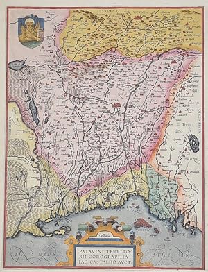
Patavini territorii corographia, Iac. Castaldo Auct.
Published by Artist: Ortelius Abraham ( - 1598 ) Antwerp ; issued in: Antwerp; - Abraham Ortelius (1527 - 1598) Antwerp comes from an Augsburg family and was born in Antwerp Spain where he lived throughout his life After thorough training he joined the Antwerp Guild of St Luke in 1547 as a card painter In 1554 he took over an antiquarian bookshop that mainly deals with the coloring distribution and publishing of maps Basically he is more of a publisher than a scholar And so he also made the acquaintance of another great man of his time Gerhard Mercator (1512-1594) who encouraged him to draw cards and to make maps of the most varied of countries His first cartographic work of his own is a large 8-sheet map of the world that appears in Antwerp in 1564 Thi, 1527
Seller: Antique Sommer& Sapunaru KG, M�nchen, Germany
Seller rating 4 out of 5 stars
Technic: Copper print, colorit: original colored, condition: Perfect condition, size (in cm): 31 x 23,5 cm; - Map shows the Veneto region with Padua and the coat of arms of Venice. - additional information: Latin edition of Ortelius' Theatrum; History: In ancient times, in northern Italy, unlike in southern Italy, there was hardly any Greek colonization. For the Roman Empire, Northern Italy was initially Gallia cisalpina. Since the Middle Ages, northern Italy has been characterized by remarkable trading cities, which, starting from the Veronese Confederation, united in the Lombardenbund against Emperor Barbarossa. At that time, some basics of business administration and banking, such as double-entry bookkeeping, were created in northern Italy. In pre-Roman centuries it was inhabited by different peoples among whom the Ligures, the ancient Veneti, who prospered through their trade in amber and breeding of horses, the Etruscans, who colonized Northern Italy from Tuscany, founded the city of Bologna and spread the use of writing; later, starting from the 5th century BC, the area was invaded by Celtic ? Gallic tribes. These people founded several cities like Turin and Milan and extended their rule from the Alps to the Adriatic Sea. Their development was halted by the Roman expansion in the Po Valley from the 3rd century BC onwards. After centuries of struggle, in 194 BC the entire area of what is now Northern Italy became a Roman province with the name of Gallia Cisalpina ("Gaul on the inner side (with respect to Rome) of the Alps"). The Roman culture and language overwhelmed the former civilization in the following years, and Northern Italy became one of the most developed and rich areas of the western half of the empire with the construction of a wide array of roads and the development of agriculture and trade. After the fall of the Western Empire, Northern Italy suffered heavily from destruction brought about by migration from Germanic peoples and from the Gothic War. In the 10th century Northern Italy was formally under the rule of the Holy Roman Empire but was in fact divided in a multiplicity of small, autonomous city-states, the medieval communes and maritime republic. The 11th century marked a significant boom in Northern Italy's economy, due to improved trading and agricultural innovations, culture flourished as well with many universities founded, among them the University of Bologna, the oldest university in Europe. In the end a balance of power was reached in 1454 with the Peace of Lodi and Northern Italy ended up divided between a small number of regional states, the most powerful were the Duchies of Savoy, Milan, Mantua, Ferrara and the Republics of Genoa and Venice, which had begun to extend its influence in the mainland from the 14th century onwards. In the 15th century Northern Italy became one of the centres of the Renaissance whose culture and works of art were highly regarded. After the French Revolution in the late 18th century Northern Italy was conquered by the French armies, many client republics were created by Napoleon and in 1805 a new Kingdom of Italy, made of all of Northern Italy but Piedmont that was annexed to France, was established with Milan as capital and Napoleon as head of state. In the congress of Vienna, the Kingdom of Sardinia was restored, and furthermore enlarged by annexing the Republic of Genoa to strengthen it as a barrier against France. The rest of Northern Italy was under Austrian rule, either direct like in the Lombardo-Venetian Kingdom or indirect like in the Duchies of Parma and Modena. Bologna and Romagna were given to the Papal State.
-
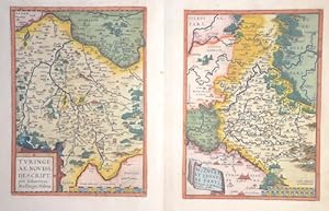
Turingiae Novis Descript." und "Misinae et Lusatiae Tabula
Published by Artist: Ortelius Abraham ( - 1598 ) Antwerp ; issued in: Antwerpen; - Abraham Ortelius (1527 - 1598) Antwerp comes from an Augsburg family and was born in Antwerp Spain where he lived throughout his life After thorough training he joined the Antwerp Guild of St Luke in 1547 as a card painter In 1554 he took over an antiquarian bookshop that mainly deals with the coloring distribution and publishing of maps Basically he is more of a publisher than a scholar And so he also made the acquaintance of another great man of his time Gerhard Mercator (1512-1594) who encouraged him to draw cards and to make maps of the most varied of countries His first cartographic work of his own is a large 8-sheet map of the world that appears in Antwerp in 1564 T, 1527
Seller: Antique Sommer& Sapunaru KG, M�nchen, Germany
Seller rating 4 out of 5 stars
Technic: Copper print, colorit: original colored, condition: Perfect condition, size (in cm): 47 x 58 cm; - Thuringia and Meissen, two maps on one sheet, each with a title cartouche and a mileage indicator. - additional information: Latin edition of Ortelius'Theatrum; History: Named after the Thuringii tribe who occupied it around AD 300, Thuringia came under Frankish domination in the 6th century. The Thuringian tribe formed during the Migration Period. The Saxon Otonen and the Sangerhausen became a center of the Holy Roman Empire in the 10th century. A separate Duchy of Thuringia cannot develop in this way. Greatest power in the Thuringian war at that time was the county of Weimar. It was only the Ludowinger rights that brought parts of Thuringia under their control. In the 12th century, the process of expanding the state in Thuringia was secured. It is called the first climbed cities such as M�hlhausen. The important noble families of medieval Thuringia were next to the dominant Wettin and the Ludowingern. In 1485, with the division of Leipzig, the wet lands were sold to the Albertiner rights in the east and the Ernestiner administration in the west. With the Reformation at the beginning of the 16th century, Thuringia became the center of German politics. Martin Luther made announcements of responsibility at the University of Erfurt and in the Augustinian monastery before he went to Wittenberg and the Reformation began. In 1640, two main Ernestine lines emerged: the House of Saxony-Weimar and the House of Saxony-Gotha. Subsequently, the phase of humanism began in Thuringia, in which the University of Erfurt also had a heyday. A center of German humanism was formed around Ulrich von Hutten and the reformers. It was only around 1780 that the ruling Duchess Anna Amalia and her son Karl August left the region again. They called poets such as Johann Wolfgang von Goethe or Friedrich Schiller and their court, where they established Weimar Classicism as a German version of the classic literary movement. In 1833, the Customs and Trade Association of the Thuringian States was founded, which spurred industrial revolution in the country. As a result of industrialization, Thuringia became the cradle of social democracy. 1869 Greater August Bebel and Wilhelm Liebknecht in Eisenach the Social Democratic Workers 'Party, in 1875 merged with the General German Workers' Association in Gotha to form the SPD. The Gotha program and the Erfurt program subsequently defined the goals of social democratic politics in Germany.