
Order Total (1 Item Items):
Shipping Destination:

American Map Columbia Atlas (3 results)
Skip to main search results
Product Type
- All Product Types
- Books
- Magazines & Periodicals
- Comics
- Sheet Music
- Art, Prints & Posters
- Photographs
- Maps (3)
-
Manuscripts &
Paper Collectibles
Condition
- All Conditions
- New
- Used
Binding
- All Bindings
- Hardcover
- Softcover
Collectible Attributes
- First Edition (1)
- Signed
- Dust Jacket
- Seller-Supplied Images (1)
- Not Printed On Demand
Seller Location
Seller Rating
-

The Citizen's Atlas of the World 1898 Map of South America Section 1 includes Venezuela, British Guiana, Columbia, Ecuador, Brazil, Peru, Bolivia and an inset of Lima Peru
Published by George Newnes, Limited, London, 1898
Seller: ABookLegacy, Mike and Carol Smith, N. Ft. Myers, FL, U.S.A.
Association Member: FABA
Seller Rating:

Map First Edition
Map. Condition: Very Good. Dust Jacket Condition: No Dust Jacket. First Edition; Various. Color Map is in sleeve and may have minor soiling to edges.Taken from theCitizens Atlas of the World, published by Newnes, etc. in Southhampton Street, 1898. Bartholomew was a cartographer, born in Edinburgh, EC Scotland, UK. He studied at Edinburgh, then entered his father's firm. His works include the Survey Atlas of Scotland (1895 1912) and a Physical Atlas of the World (2 vols, 1889 1911). He is best known for his system of layer colouring of contours. These are NOT reprints they are directly from the 1898 Atlas which was damaged with the loss of some original maps. Shows major transportation routes, including railways, rivers, lakes, town names, territorial names, township names, county names, land masses, etc. Map now in archival sleeve and backing board. These maps give a very contrasting view of the World in 1898 as compared to today in light of globalization. Other maps available. Scarce in this condition. Great reference and for framing.; Color Map; 14x18 inches.
-
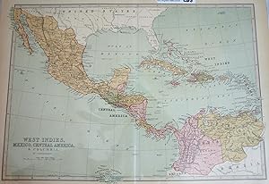
A Descriptive Hand Atlas of the World Map of West Indies, Mexico, Central America, and Columbia
Published by T. Ellwood Zell, 1873
Map
Map. Condition: Very Good. 13-1/2 x 17 inches. Full color steel plate engraving, extracted from A Descriptive Hand Atlas of the World, printed by T. Ellwood Zell. Map title in lower left above scale. Vertical crease through center of page. Slight discoloration to borders. Very small dark stain in lower right, not affecting map. Bright, distinct colors. Lines are crisp and vivid. Text is easily legible. A superior map in very good condition.
-
Atlas Universel De Geographie, Physique, Politique Et Mineralogique North America - Map of Vancouver British Columbia and Vancouver Island (Partie De La Nouvelle Hanovre)
Published by Lithographed By H. Ode, Brussels, Belgium, 1827
Map
Map. Condition: Very Good. Map # 51, A Very Good primitive and early map showing Vancouver, British Columbia and Vancouver Island in Canada. Includes some of extreme NW Washington state adjacent to, but not including Seattle, also includes the city of Victoria. Very nice multi-color depiction of the larger British Columbia coastline. Latitude of the map is 48 degrees to 54 degrees and longitude is 119 degrees to 131 degrees. Of course, almost all localities shown are French or Indian names. The atlas from which this is extracted is extremely rare and originally composed 6 volumes, this map being from the North America volume. Lithographer Ode and Cartographer Vandermaelen produced the first lithographed atlas ever done. Condition is overall Very Good. Browning to the centerfold crease caused by glue used in attaching the tab to the original volume, the two page spread measures 21" x 26 1/2" when opened out. Topigraphical features are accentuated, see image. Shipping will require extra care and cost due to insurance. Photo available upon request. ; 21" x 26 1/2"; 1 pages.
