Order Total (1 Item Items):
Shipping Destination:

Chili Argentine Republic Paraguay Uruguay (19 results)
Skip to main search results
Product Type
- All Product Types
- Books (15)
- Magazines & Periodicals
- Comics
- Sheet Music
- Art, Prints & Posters
- Photographs
- Maps (4)
-
Manuscripts &
Paper Collectibles
Condition
- All Conditions
- New
- Used
Binding
- All Bindings
- Hardcover
- Softcover (1)
Collectible Attributes
- First Edition (2)
- Signed
- Dust Jacket
- Seller-Supplied Images (15)
- Not Printed On Demand
Seller Location
Seller Rating
-
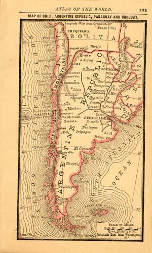
With the 19th century innovations of publishing and technology, the world became a smaller place and one which anyone could become acquainted with. As these changes blossomed, the fledgling company of Rand McNally realized the interest in small accessible material, and produced a pocket atlas. These maps carry handy reference information, and were up to date for the period. They include cities, some towns as well as some roads. They have their own charm and would be great for framing, and decorative use. This map measures 5 inches by 3 inches.
-
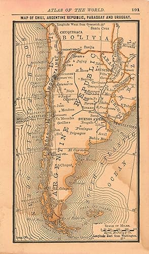
With the 19th century innovations of publishing and technology, the world became a smaller place and one which anyone could become acquainted with. As these changes blossomed, the fledgling company of Rand McNally realized the interest in small accessible material, and produced a pocket atlas. These maps carry handy reference information, and were up to date for the period. They include cities, some towns as well as some roads. They have their own charm and would be great for framing, and decorative use. This map measures 5 inches by 3 inches.
-
Condition: Good. Colton's Argentine Republic, Chili, Uruguay & Paraguay. Argentina Chile 1863 map. Antique engraved hand coloured atlas map; Joseph Hutchins Colton (1863). 41.5 x 34.5cm, 16.5 x 13.5 inches. Condition: Good. There is text printed on the reverse side.
-
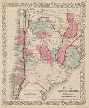
Chili, Argentine Republic, Paraguay and Uruguay
Published by Charles Desilver, Philadelphia, 1856
Seller: Main Street Fine Books & Mss, ABAA, Galena, IL, U.S.A.
Association Member: ABAA ILAB MWABA
Seller Rating:

Map
13 3/4" X 17�" (image 12�" X 15"). Hand colored. Very good. Unfortunate but not terribly disfiguring discoloration at upper right corner (touching image slightly). Clear, colorful map. Nice, brightly colored example with interesting small inset at lower right showing "South Part of Patagonia." Sharp decorative border.
-
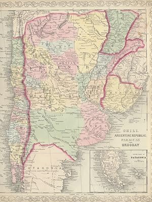
Argentine Republic, Chili, Uruguay & Paraguay
Published by New York c.1857, New York, 1857
Seller: High Ridge Books, Inc. - ABAA, South Deerfield, MA, U.S.A.
Association Member: ABAA ESA ILAB SNEAB
Seller Rating:
Map of much of the southern region of South America from Colton's General Atlas. The top corner containing the map number is chipped off. Full color by state. Grape vine border. Shows Uruguay, Paraguay and the northern regions of Chile and Argentina. Extends south to the Gulf of San Marias in the east. Does not show Patagonia or the southern areas near Cape Horn.
-

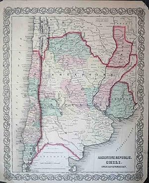
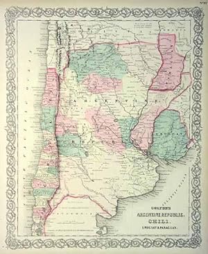
Colton's Map of the Argentine Republic, Chili, Uruguay & Paraguay.
Published by New York:, 1866
Seller: Nicholas D. Riccio Rare Books, ABAA, Florham Park, NJ, U.S.A.
Seller Rating:
Unbound, colored engraved map, 16 " x 13". Some toning and aging, margin chips and nicks, a little creasing; otherwise bright and clean and in very good condition. Maps are wrapped with acid free board, or in rigid sleeves.� � Beginning with J. H. Colton (1800-1893), the Colton family published atlases for over 30 years. Colton's Atlas of the World was first published in 1855 in a large two volume set. In 1857 it became Colton's General Atlas, and Colton's sons, George Woolworth and Charles B. would take over the business. This is a fairly attractive map of an important portion of South America, including Argentina and Chili, from the rather scarce 1866 edition of Colton's General Atlas.� � Ristow 313-326.
-
Art Source International is proud to offer this map from the 1859 edition of Coltons General Atlas. Colton atlases, especially those from the late 1850's, have become increasingly rare. The General Atlas was the first single edition atlas published by the Colton brothers succeeding the expensive two volume Atlas of the World. These maps have the signature ' inch Colton border surrounding each map. The Colton firm refused to compromise quality, choosing to compete for sales in the finer quality international market rather than the cheap domestic one. Because of this, all maps were engraved by steel plates rather than by wax engraving which was the most common method used at this time. This map of Argentine Republic, Chili, Uruguay & Paraguay is very detailed with identification of provinces, cities, towns, transportation routes, rivers, and mountain ranges. Each map has beautiful muted red, green, tan, pink, and yellow hand coloring. This map measures 15 inches by 13 inches.
-

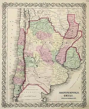
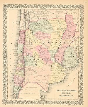
Colton's Map of the Argentine Republic, Chili, Uruguay & Paraguay.
Published by J.H. Colton & Co.,, New York:, 1857
Seller: Nicholas D. Riccio Rare Books, ABAA, Florham Park, NJ, U.S.A.
Seller Rating:
Unbound, colored engraved map, 16 " x 13". Some toning and aging, foxing or soiling in margins; still generally bright and clean and in very good condition. Maps are wrapped with acid free board, or in rigid sleeves. Beginning with J. H. Colton (1800-1893), the Colton family published atlases for over 30 years. Colton's Atlas of the World was first published in 1855 in a large two volume set. In 1857 it became Colton's General Atlas, and Colton's sons, George Woolworth and Charles B. would take over the business. This is a fairly attractive map of an important portion of South America, including Argentina and Chili, from the rather scarce 1857 edition of Colton's General Atlas. J.H. Colton is named as the publisher on the map. May require extra postage. Ristow 313-326. # 103174 $85.
-
Pamphlet. Condition: Good. Map is 18.5 x 16 inches, Elaborate border, Hand-WaterColored in Pastels, light brn dampstain just touches lower left corner & top center of elaborate border (it would not be noticed once map is framed) else VG & Attractive & Could be Beautifully Framed (Map is dated 1855) (Shows Patagonia "Inhabited by wandering tribes of Indians").
-
Art Source International is proud to offer this map from the 1856 edition of Coltons Atlas of the World. Colton atlases, especially those from the 1850's, have become increasingly rare. These maps have the signature 3/4" Colton border surrounding each map. The Colton firm refused to compromise quality, choosing to compete for sales in the finer quality international market rather than the inexpensive domestic one. Because of this, all maps were engraved by steel plates rather than by wax engraving which was the most common method used at this time. This map is very detailed with identification of provinces and or regions, cities, towns and villages, transportation routes including rail roads, common roads, canals, rivers, lakes, and mountain ranges. Each map has beautiful muted red, green, tan, pink, or yellow hand coloring. These are the only Colton maps we have encountered with outline color. This map measures 15 inches by 12 inches.
-
Art Source International is proud to offer this map of the Argentine Republic, Chili, Uruguay, and Paraguay from the 1856 edition of Coltons Atlas of the World. Colton atlases, especially those from the 1850's, have become increasingly rare. The Colton maps were engraved by steel plates rather than by wax engraving, which was the most common method used at this time. These maps are very detailed in beautiful hand colored pastels, and feature Colton's signature 3/4 inch border. This map shows countries and/or regions, cities, towns and villages, transportation routes, common roads, canals, rivers and lakes, and other geographical features. ' This map measures 16 inches by 13 inches.
-
Art Source International is proud to offer this map from the 1873 edition of Colton's General Atlas. Colton atlases, especially those from the early 1870's, have become increasingly rare. This map has been very well maintained. Its original hand coloring remains quite rich. This map measures 13 inches by 16 inches.
-

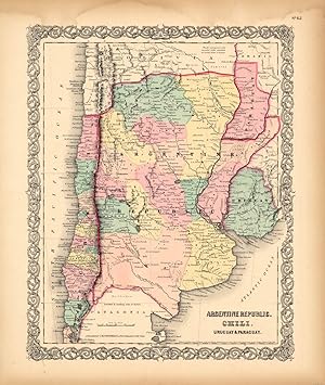
Art Source International is proud to offer this map from the 1857 edition of Coltons General Atlas. Colton atlases, especially those from the late 1850's, have become increasingly rare. The General Atlas was the first single edition atlas published by the Colton brothers succeeding the expensive two volume Atlas of the World. The Colton firm refused to compromise quality, choosing to compete for sales in the finer quality international market rather than the cheap domestic one. Because of this, all maps were engraved by steel plates rather than by wax engraving which was the most common method used at this time. This map of Argentine Republic, Chili, Uruguay and Paraguay is very detailed. It shows lakes and rivers, mountains, regions and or provinces, railroads, wagon trails, cities and towns, and many other details. Muted pastel hand coloring in pink, blue, green, and yellow. This map measures 14.5 inches by 12 inches.
-

We are pleased to offer this map issued as part of Colton's General Atlas, published in 1865. The Civil War ended April 9, 1865 and this atlas was one of the first post-Civil War atlas' published. Colton continued his tradition of beautiful hand coloring with this atlas. This map measures 16 inches by 13 inches.
-
THE ARGENTINE REPUBLIC, CHILI, PARAGUAY, URUGUAY . An extremely detailed map.
Published by Edward Stanford 1894, 1894
Map
65 x 50 cm. Full original colour.
-
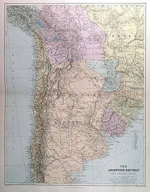
THE ARGENTINE REPUBLIC, CHILI, PARAGUAY, URUGUAY . An extremely detailed map with additional railways etc.
Published by Edward Stanford 1904, 1904
Map
65 x 50 cm. Full original colour.
-
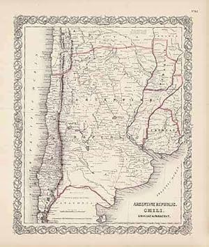
[Map] Argentine Republic, Chili, Uruguay & Paraguay
Published by J. H. Colton, New York, 1857
Seller: PLAZA BOOKS ABAA, Port Townsend, WA, U.S.A.
Seller Rating:
4 ff., rom Colton's Atlas of the World, hand-colored, steel-engraved map, 18.5 x 16in. WITH 3 folio sheets (same size as map) of the accompanying "Descriptions Geographical, Statistical, and Historical, by Richard Swainson Fisher, M.D." Colton's Atlas of the World was published in two volumes,; this map is from "Volume 1, North and South America etc." A little age-toned, but very good.
-
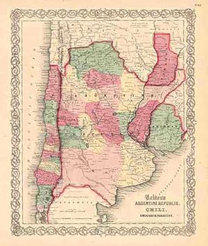
We are excited to offer maps from the 1871 edition of Coltons Atlas of America. In our 25 years these are the first Colton maps from 1871 we have been able to acquire. The Colton firm refused to compromise quality, choosing to compete for sales in the finer quality international market rather than the inexpensive domestic one.Because of this, all maps were engraved by steel plates rather than by wax engraving which was the most common method used at this time. This map of Argentina, Chili, Uruguay and Paraguay is very detailed with identification of regions, important cities, rivers, lakes, mountain ranges, and railroad lines. Each map has beautiful red, green, tan, pink, and yellow hand coloring used to distinguish regions. ' This map measures 16 inches by 13.5 inches.
-
Joseph Hutchins Colton (1800-1893) started one of the premier map publishing firms in the U.S. His first printed map dated 1833, was a reprint of David Burrs map of the state of New York. The Colton firm was one of the primary publishers of guidebooks, immigrant maps, and railroad maps. In 1855 Colton issued his first atlas, "Colton's Atlas of the World." They refused to compromise quality, choosing to compete for sales in the finer quality international market rather than the inexpensive domestic one. Because of this, all maps were engraved by steel plates rather than by wax engraving which was the most common method used at this time. This map is very detailed with identification of provinces and or regions, cities, towns and villages, transportation routes including rail roads, common roads, and canals, rivers and lakes, battle fields, and mountain ranges. Each map has beautiful muted red, green, tan, pink, and yellow hand coloring. Art Source International is proud and excited to offer maps from this very rare atlas. We have been in the antique map business for over forty years and these are the true first edition maps (1855) we have ever offered. Don't wait too long to purchase this piece of American mapping history! This map measures 16 inches by 13 inches.