
Order Total (1 Item Items):
Shipping Destination:

Eastern United by Rand Mcnally (17 results)
Skip to main search results
Product Type
- All Product Types
- Books (16)
- Magazines & Periodicals
- Comics
- Sheet Music
- Art, Prints & Posters
- Photographs
- Maps (1)
-
Manuscripts &
Paper Collectibles
Condition
Binding
- All Bindings
- Hardcover
- Softcover
Collectible Attributes
- First Edition (2)
- Signed
- Dust Jacket
- Seller-Supplied Images (8)
- Not Printed On Demand
Free Shipping
Seller Location
Seller Rating
-

Rand McNally Folded Map: Eastern United States Map
Published by Rand McNally, 2021
ISBN 10: 0528024604ISBN 13: 9780528024603
Book
Condition: Good. Book is in Used-Good condition. Pages and cover are clean and intact. Used items may not include supplementary materials such as CDs or access codes. May show signs of minor shelf wear and contain limited notes and highlighting.
-
Rand McNally Folded Map: Eastern United States Map
Published by Rand McNally, 2021
ISBN 10: 0528024604ISBN 13: 9780528024603
Book
Condition: Fine. Like New condition. Great condition, but not exactly fully crisp. The book may have been opened and read, but there are no defects to the book, jacket or pages.
-
Rand McNally Folded Map: Eastern United States Map
Published by Rand McNally, 2021
ISBN 10: 0528024604ISBN 13: 9780528024603
Book
Condition: Very Good. Very Good condition. Shows only minor signs of wear, and very minimal markings inside (if any).
-
Rand McNally Folded Map: Eastern United States Map
Published by Rand McNally, 2021
ISBN 10: 0528024604ISBN 13: 9780528024603
Book
Condition: Very Good. Book is in Used-VeryGood condition. Pages and cover are clean and intact. Used items may not include supplementary materials such as CDs or access codes. May show signs of minor shelf wear and contain very limited notes and highlighting.
-
Rand McNally Folded Map: Eastern United States Map
Published by Rand McNally, 2021
ISBN 10: 0528024604ISBN 13: 9780528024603
Book
Condition: Fine. Book is in Used-LikeNew condition. Pages and cover are clean and intact. Used items may not include supplementary materials such as CDs or access codes. May show signs of minor shelf wear.
-
Rand McNally Folded Map: Eastern United States Map
Published by Rand McNally, 2021
ISBN 10: 0528024604ISBN 13: 9780528024603
Book
Condition: New. Book is in NEW condition.
-
Rand McNally Folded Map: Eastern United States Map
Published by Rand McNally, 2021
ISBN 10: 0528024604ISBN 13: 9780528024603
Book
Condition: New. New! This book is in the same immaculate condition as when it was published.
-

Rand McNally Eastern United States (USA Sectional Maps)
Published by Rand Mcnally
ISBN 10: 0528960520ISBN 13: 9780528960529
Seller: Wonder Book, Frederick, MD, U.S.A.
Seller Rating:

Book
Condition: Good. Good condition. A copy that has been read but remains intact. May contain markings such as bookplates, stamps, limited notes and highlighting, or a few light stains.
-
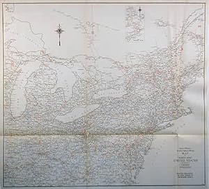
Rand McNally made this "Commercial Atlas of America" in 1920. The Eastern United States is illustrated on this large, very detailed map. Counties, cities, towns, churches, important land forms, train stations, railroad lines, major roads, post offices and telegraph stations are all identified. Each existing railroad route is mapped and stations are identified by a number which corresponds to a key providing its name. The populations of principal cities are provided in the margin. This map measures 26 inches by 19 inches.
-
Rand McNally County-Population Map of the United States Eastern Section
Publication Date: 1930
First Edition
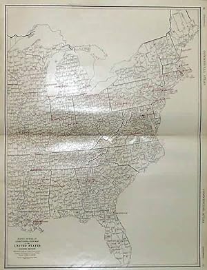
Rand McNally & Company, still a major name in map publishing to this day, began as a small print shop opened in Chicago in 1856 by William H. Rand. The shop originally printed guidebooks and directories. In 1858, Rand hired Andrew McNally who was later to become a partner. Within the next few years, the shop got into the railroad business by starting to print railway tickets and schedules, a key step in the development of the company. The ticket printing led to the publishing of railway guides, and by 1872 Rand McNally and Company had the capacity to publish maps. This map of The United States Eastern Section (population by county) came from Rand McNally's Commercial Atlas, sixty-first Edition dated 1930. A highly successful run of atlases that lasted over a decade. These maps were primarily used by business, because of their accurate listing of railroads in operation as well as tables of statistical information. This map includes all cities and towns, lakes, rivers, and bodies of water. All topographical features are also included as well as political features such as regions and provinces. This map measures 25 inches by 19 inches.
-
Rand McNally & Company, still a major name in map publishing to this day, began as a small print shop opened in Chicago in 1856 by William H. Rand. The shop originally printed guidebooks and directories. In 1858, Rand hired Andrew McNally who was later to become a partner. Within the next few years, the shop got into the railroad business by starting to print railway tickets and schedules, a key step in the development of the company. The ticket printing led to the publishing of railway guides, and by 1872 Rand McNally and Company had the capacity to publish maps. This map of The United States Eastern Section came from Rand McNally's Commercial Atlas, sixty-first Edition dated 1930. A highly successful run of atlases that lasted over a decade. These maps were primarily used by business, because of their accurate listing of railroads in operation as well as tables of statistical information. This map includes all cities and towns, lakes, rivers, and bodies of water. All topographical features are also included as well as political features such as regions and provinces. This map measures 25 inches by 19 inches.
-
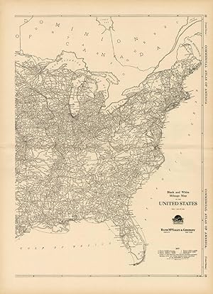
The 1936, sixty-seventh edition of the "Rand McNally Commercial Atlas and Marketing Guide" is unique in its inclusion of informative details. This black and white map shows the highway milage between points in the north-eastern United States with an inset showing eastern Maine. The names of towns along highways are shown in black and state boarders and principal cities are shown in red. This map measures 27 inches by 29 inches.
-

Rand McNally Eastern United States: Regional Map
Published by Rand McNally & Company, 2014
ISBN 10: 0528881159ISBN 13: 9780528881152
Book
Condition: good. 100% Customer Satisfaction Guaranteed ! The book shows some signs of wear from use but is a good readable copy. Cover in excellent condition. Binding tight. Pages in great shape, no tears. Not contain access codes, cd, DVD.
-

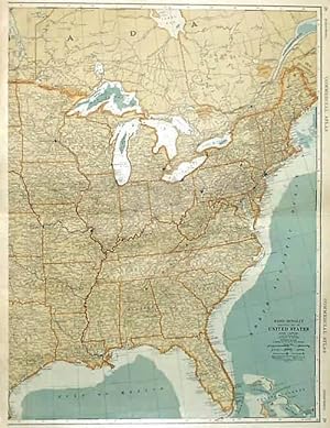
This map was produced by Rand McNally and Co. as part of its 1928 Commercial Atlas of America. These maps are some of our favorite maps because of the large size of each map sheet. The detail shown on each map is exceptional because of the map size. These maps were intended to be used by business for shipping and other uses. Roads, railroads, rivers, and buildings are clearly shown. There is more detail on these maps than any others during this time period. This map measures 20.5 inches by 14 inches.
-

Rand McNally Eastern United States: Regional Map
Published by Rand McNally, 2010
ISBN 10: 0528881159ISBN 13: 9780528881152
Book
map. Condition: Good. Orders shipped daily from the UK. Professional seller.
-
26 1/4 x 23 inches. Condition: Very good condition. This is a very attractive map of the United States; just east of the Mississippi River to the Atlantic Ocean. The Florida Peninsula is shown in an inset map. This map was sponsored by the 56 hotels listed on the front. Some of the hotels have larger ads on the verso of the map. There is a striking use of color on this map on a soft white background. For the automobile traveler of the period it was a valuable tool to have on board.
-

Rand McNally Eastern United States: Regional Map
Published by Rand McNally & Company, 2014
ISBN 10: 0528881159ISBN 13: 9780528881152
Book
Condition: new. Book is in NEW condition. Satisfaction Guaranteed! Fast Customer Service!!.
