Order Total (1 Item Items):
Shipping Destination:

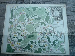
Fluvius Newa Lacu Ladoga 1760 by Lotter C T 1717 1777 (1 results)
Feedback
Skip to main search results
Search filters
Product Type
- All Product Types
- Books (No further results match this refinement)
- Magazines & Periodicals (No further results match this refinement)
- Comics (No further results match this refinement)
- Sheet Music (No further results match this refinement)
- Art, Prints & Posters (No further results match this refinement)
- Photographs (No further results match this refinement)
- Maps (1)
- Manuscripts & Paper Collectibles (No further results match this refinement)
Condition
- All Conditions
- New (No further results match this refinement)
- Used (1)
Binding
- All Bindings
- Hardcover (No further results match this refinement)
- Softcover (No further results match this refinement)
Collectible Attributes
- First Edition (No further results match this refinement)
- Signed (No further results match this refinement)
- Dust Jacket (No further results match this refinement)
- Seller-Supplied Images (1)
- Not Print on Demand (1)
Free Shipping
- Free Shipping to U.S.A. (No further results match this refinement)
Seller Rating
-
Kein Einband. Condition: Gut. Fluvius Newa e Lacu Ladoga, 1760, Lotter T.C. Flow of the Neva River from Lake Ladoga to Saint Petersburg. Fluvius Newa e Lacu Ladoga Petropolin versus procurrens recens delineatus jam vero ad exemplar Petropolitanum aeri incissus a Matthaeus Seutter, Sac. Caes. Maj. Geogr. Aug.Vind. Cum Priv. Sumi. Vicariat. in part. Rheni, Franc. et Suev. jur. Copperplate engraving. Size of the leaf. 55X66 cm., here in original publishers colours, little brownish, some ink spots. Here edited by Tobias conrad Lotter, the son in law of Seutter Matth�us, circa 1760. With the parallel Latin title. Place names are written in Latin letters parallel to the Cyrillic alphabet. It is a map of the Neva Riva, from its source to the place where the Okhta flows into it. The map covers also the adjoining parts of Karelia and Ingermandland. This map is a fragment of the map Lake Ladoga and the Finish Gulf with their Immediate Environs., produced at a larger scale. The map shows populated places (indicated by individual houses and blocks of buildings), part of Saint Petersburg (around the Okhta), the Neva Monastery, roads, the Ladoga Canal, factories, temporary bridges, fortresses, estates, a tavern at the mouth of the Mga River, a "poor house", agricaltural lands, meadow vegetation, forests, marshes, sandbanks. The title of the map is displayed within a decorative cartouche representing allegorical figures with coarts of arms of Saint Petersburg and the Russian Empire, a horn of plenty. They are surrounded by symbols of fishing, farming and military attributes. The map was engraved by the publishing firm of Matteus Seutter in Augsburg. It is a replica of the map, compiled by the Petersburg.