Order Total (1 Item Items):
Shipping Destination:

Gerardus Mercator Rupelmundanus (12 results)
Skip to main search results
Product Type
- All Product Types
- Books (10)
- Magazines & Periodicals
- Comics
- Sheet Music
- Art, Prints & Posters
- Photographs
- Maps (2)
-
Manuscripts &
Paper Collectibles
Condition
- All Conditions
- New
- Used
Binding
Collectible Attributes
- First Edition (1)
- Signed
- Dust Jacket (2)
- Seller-Supplied Images (6)
- Not Printed On Demand
Seller Location
Seller Rating
-
Gerardus Mercator rupelmundanus
Published by Fonds Mercator, 1997
ISBN 10: 9061533805ISBN 13: 9789061533801
Book
Paperback. Condition: Poor. Da�os por agua. 93 p. : illustrations en coul., couv. illustrations en coul. ; 33 cm Cartographie -- Histoire, 16e s. Text Spanish.
-

Gerardus Mercator rupelmundanus.
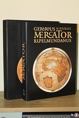
Published by Antwerpen/Paris, Mercatorfonds/Paribas, 1994., 1994
ISBN 10: 9061533139ISBN 13: 9789061533139
Book
26 x 34, 446 pages, tr�s nombreuses illustrations en couleurs (very many color pictures), reliure d'�dition pleine toile + jaquette rempli�e (hardcover + dustjacket), sous �tui carton noir illustr�, tr�s bon �tat (very fine condition). Livre en n�erlandais.
-
Gerardus Mercator Rupelmundanus
Published by Mercatorfonds.
ISBN 10: 9061533139ISBN 13: 9789061533139
Seller: Emile Kerssemakers ILAB, Heerlen, Netherlands
Seller Rating:

Book
1994, 446pp. Ge�llustreerd. Linnen, met stofomslag. In cassette. In z��r goede staat. Pakketzending.
-

Gerardus Mercator Rupelmundanus. Met bijdragen van J�zef Babicz, Christa Binder, [et al.]
Seller: Antiquariaat A. Kok & Zn. B.V., Amsterdam, Netherlands
Seller Rating:
[Antwerpen], Mercatorfonds Paribas, [1994]. 446 pp. Col. & b./w. ills. Orig. hardcover (dark green cloth, gild print on front cover, gilt lettering on spine), d./j. In orig. slipcase. 4to.Text in Dutch.
-
Gerardus Mercator Rupelmundanus
Published by [Antwerpen], Mercatorfonds Paribas 1994, 1994
Seller: Antiquariaat Pieter Judo (De Lezenaar), Hasselt, Belgium
Association Member: ILAB
Seller Rating:
446 + [2] pp. rijkelijk ge�llustreerd, 34cm., groene linnen uitgeversband met titel in goudopdruk, stofwikkel, in gecart. etui van uitgever, zeer goede staat, tekst in het Nederlands (text in Dutch), gewicht: 3.9kg., B100310.
-
MERCATOR, GERARDUS MERCATOR RUPELMUNDANUS.
Published by Antwerpen Mercatorfonds 1994, 1994
linnen band met goudstempeling, geplastificeerde stofomslag, 340 x 260 mm., 448 pp., 450 illustraties waarvan 350 in kleur. Cassette. ISBN 9061533139. Belicht belangrijkste aspecten van Mercators oeuvre, zijn rijke persoonlijkheid en zijn historische betekenis met zijn kaarten als rode draad. 3800 g.
-
Gerardus Mercator Rupelmundanus
Published by Mercatorfonds, 1994
ISBN 10: 9061533139ISBN 13: 9789061533139
Book
Original Cloth. Condition: As New. Dust Jacket Condition: As New. Gerardus Mercator Rupelmundanus 335 x 255 mm, hard cover met stofwikkel en schuifdoos, 446 blz, talloze illustraties, prachtig standaardwerk mbt Mercator, zeer goede staat.
-
446 p. Linnen met stofomslag en cassette, mooi exemplaar.
-
Gerardus Mercator Rupelmundanus [In Slipcase].
Published by Antwerpen, Mercatorfonds 1994, 1994
ISBN 10: 9061533139ISBN 13: 9789061533139
Book
Original publisher's green cloth hardback, gilt lettering spine, gilt ornament frontcover, large 4to, frontispiece portrait, 448pp. 450 illustrations [350 coloured], notes, bibliography, photo credits, index names, geographical index. In pictorial slipcase. Text in DUTCH. - as new [In Slipcase]. Weight 4 kg.
-
FLANDRIA. EN MARGEN INFERIOR IZQUIERDA EN EL INTERIOR DEL �VALO - GERARDUS MERCATOR RUPELMUNDANUS-DESCRIBEBAT (FLANDES, COMO ES DESCRITA POR GERARDUS MERCATOR) CUM PRIUILEGIO.
Published by Amberes, 1579
Seller: LIBRERIA ANTICUARIA MARGARITA DE DIOS, MADRID, Spain
Association Member: LANCE
Seller Rating:
First Edition
Condition: Muy bien. 1 Edici�n. Materia:Cartograf�a antigua del siglo XVI. Ortelius. Flandes (B�lgica - Francia), frontera de Artois, Hannonia, Brabante. Publicaci�n: Amberes, Atlas Theatrum Orbis Terrarum, 1579. Impresor: Franciscus Hogenbergus. T�cnica: Grabado calcogr�fico. / Reverso: texto en lat�n. Notas: Pertenece a la primera plancha primer estado, realizada en 1579, de la que se tiraron 250 ejemplares. Se tiraron aproximadamente 2600 impresiones de este mapa. Fuentes Cartogr�ficas: Mapa de Flandes de 1549 de Gerard Mercator (Karrow 56/6, p. 379-382, Meurer p. 196). Conservaci�n: Mapa en blanco y negro. Perfecto estado de conservaci�n. Impreso en papel grueso y fuerte de gran calidad, muy limpio. Medidas: 350 X 490 mm. Dimensi�n total: 440 X 570 mm.
-
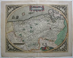
Altkolorierte Orig. Kupferstichkarte um 1570, nach der erstmals 1539 erschienen Karte von Gerard Mercator herausgegeben von Abraham Ortelius f�r seinen monumentalen Atlas "Theatrum Orbis Terrarum", dem ersten modernen Weltatlas. Die ovale Karte bildet Flandern von der Grenze zur Picardia bis Antwerpen und von der Nordsee bis Douai, zwei Karavellen, Windrose und Meeresmonster in der Nordsee, unten Fl�min mit �hrenb�ndel und fl�mischen Wappen, in den Ecken Windrichtungen in Latein, r�ckseitig typografisch bedruckt. 38 x 49,5 cm / 45 x 56,5 cm. - Falz teils gebrochen, r�ckseitig verst�rkt, in den �u�ersten R�ndern kleine L�suren la Gewicht in Gramm: 550.
-
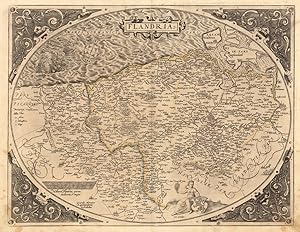
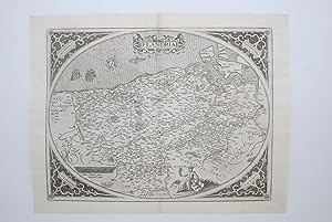
Flandria. Gerardus Mercator Rupelmundanus Describebat.
Published by Platin, Antwerpen, 1572
Seller: Antiquariat Reinhold Berg eK Inh. R.Berg, Regensburg, Germany
Seller Rating:

Map
Other. Original antique copper engraving, uncolored as published. This very decorative antique map shows Flanders from Greuelinge in the west to Brussels in the east and Schouwen in the north and Lens in the south. The corners of the oval map are engraved with the cardinal points. In the North Sea are 2 sailing ships that fire with cannons, a decorative compass rose and a sea monster. The title is engraved in the center of a very nice cartoushe. In excellent condition. 385 by 503mm (15 by 19 inches).