Order Total (1 Item Items):
Shipping Destination:

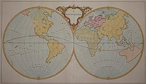
Mappe Monde by Jean Palairet (1 results)
Product Type
- All Product Types
- Books
- Magazines & Periodicals
- Comics
- Sheet Music
- Art, Prints & Posters
- Photographs
- Maps (1)
- Manuscripts & Paper Collectibles
Condition
Binding
- All Bindings
- Hardcover
- Softcover
Collectible Attributes
- First Edition
- Signed
- Dust Jacket
- Seller-Supplied Images (1)
- Not Print on Demand (1)
Free Shipping
- Free US Shipping
Seller Location
Seller Rating
-
Kein Einband. Condition: Gut. Es handelt sich hierbei um eine seltene, originale, kolorierte Kupferstich-Weltkarte von Jean Palairet aus dem Jahr 1755. *** Titel: Ie Mappe-Monde *** Gebiet bzw. Ort: Weltkarte *** Kartograph: Jean Palairet (1697 1774) *** Jahr: 1755 *** Gr��e des Plattenbereichs: 43 x 71 cm *** Technik: Kupferstich *** Zustand (Perfekt/ Sehr gut/ Gut/ Ordentlich/ M��ig/ Schlecht): In gutem Erhaltungszustand. Altersgem�� leicht gebr�unt. *** Bemerkungen: Eine dekorative und seltene Weltkarte in zwei Hemisph�ren. Die Karte zeigt das Bild der Welt im fr�hen 18. Jahrhunderts, noch ohne die gro�en Entdeckungen der Expeditionen im Pazifik des sp�teren 18. Jahrhunderts. Die Darstellung Australiens und Neuseelands orientiert sich folglich noch an den Erkenntnissen Abel Tasmans aus dem Jahr 1624. Aus Pailarets "Atlas Methodique compose pour l'usage de Son Altesse Serenissime Monseigneur le Prince d'Orange et de Nassau .". Jean Palairet (1697 1774) war ein in Montauban geborener franz�sischer Kartograph, der in London lebte und dort u.a. als Privatlehrer am Hof Georg II. arbeitete. *** English description: A rare and decorative map of the world in two hemispheres. The map shows the cartographic knowledge of the world at the beginning of the 18th century, still without the new discoveries through the expeditions in the Pacific which took place later in the 18th century. Therefore the representation of Australia and New Zeeland is still based on the descriptions by Abel Tasman, deriving from his expedition in 1624. The map is in good condition with some light browning due to age and comes from Pailaret's "Atlas Methodique compose pour l'usage de Son Altesse Serenissime Monseigneur le Prince d'Orange et de Nassau .". Jean Palairet (1697 1774) was a french cartographer, born in Montauban, who lived in London and worked as a private teacher on the court of George II. - - - International buyers welcome. If you have any questions, please don't hesitate to ask. --- Auf Wunsch stellen wir Ihnen gerne ein kostenfreies Echtheitszertifikat aus --- If you wish, we will gladly provide a certificate of authenticity free of charge ---.