Order Total (1 Item Items):
Shipping Destination:

Neatly Dissected Instruction Young by Shefrin Jill (3 results)
Product Type
- All Product Types
- Books (3)
- Magazines & Periodicals
- Comics
- Sheet Music
- Art, Prints & Posters
- Photographs
- Maps
- Manuscripts & Paper Collectibles
Condition
Binding
Collectible Attributes
- First Edition
- Signed
- Dust Jacket
- Seller-Supplied Images (2)
- Not Print on Demand (3)
Free Shipping
Seller Location
Seller Rating
-
Neatly Dissected, for the Instruction of Young Ladies & Gentlement in the Knowledge of Geography
Published by Cotsen Occasional Pr
ISBN 10: 0966608410ISBN 13: 9780966608410
Book
Condition: Good. Item in good condition. Textbooks may not include supplemental items i.e. CDs, access codes etc.
-
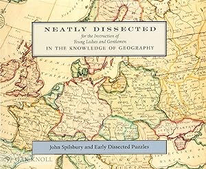
NEATLY DISSECTED FOR THE INSTRUCTION OF YOUNG LADIES AND GENTLEMEN IN THE KNOWLEDGE OF GEOGRAPHY: JOHN SPILSBURY AND EARLY DISSECTED PUZZLES
Published by Cotsen Occasional Press, Los Angeles, 1999
ISBN 10: 0966608429ISBN 13: 9780966608427
Seller: Oak Knoll Books, ABAA, ILAB, NEW CASTLE, DE, U.S.A.
Seller Rating:

Book
paperback. 9 x 7.5 (landscape). paperback. 40 pages. John Spilsbury, who styled himself an "Engraver and Map Dissector in Wood, in Order to Facilitate the Teaching of Geography," is credited with the invention of "dissected maps", hand-colored maps, printed from copper plates, which were mounted on thin sheets of mahogany and cut into pieces according to the political borders of the region mapped. The discovery of an extraordinary set of five of John Spilsbury's dissected puzzles, and its acquisition by the Cotsen Children's Library has provided a valuable opportunity to reassess Spilsbury's intention and the place of dissected puzzles and other geographical pastimes in the history of education in eighteenth-century Britain. This study of the context in which these puzzles first appeared reveals the extent of the links between the childrens book and map trades in 18th-century London, and sheds new light on the history of progressive British education during that time. "[A] well-documented discussion of (for many readers) an unfamiliar form of publication." T. H. Howard-Hill, University of South Carolina, Editor, The Papers of the Bibliographical Society of America.
-
NEATLY DISSECTED FOR THE INSTRUCTION OF YOUNG LADIES AND GENTLEMEN IN THE KNOWLEDGE OF GEOGRAPHY: JOHN SPILSBURY AND EARLY DISSECTED PUZZLES
Published by Cotsen Occasional Press, Los Angeles, 1999
ISBN 10: 0966608429ISBN 13: 9780966608427
Seller: Oak Knoll Books, ABAA, ILAB, NEW CASTLE, DE, U.S.A.
Seller Rating:
Book
cloth. 9 x 7.5 (landscape). cloth. 40 pages. John Spilsbury, who styled himself an "Engraver and Map Dissector in Wood, in Order to Facilitate the Teaching of Geography," is credited with the invention of "dissected maps", hand-colored maps, printed from copper plates, which were mounted on thin sheets of mahogany and cut into pieces according to the political borders of the region mapped. The discovery of an extraordinary set of five of John Spilsbury's dissected puzzles, and its acquisition by the Cotsen Children's Library has provided a valuable opportunity to reassess Spilsbury's intention and the place of dissected puzzles and other geographical pastimes in the history of education in eighteenth-century Britain. This study of the context in which these puzzles first appeared reveals the extent of the links between the children's book and map trades in 18th-century London, and sheds new light on the history of progressive British education during that time. "[A] well-documented discussion of (for many readers) an unfamiliar form of publication." T. H. Howard-Hill, University of South Carolina, Editor, The Papers of the Bibliographical Society of America.