
Order Total (1 Item Items):
Shipping Destination:

Shasta Topographic Map (4 results)
Skip to main search results
Product Type
- All Product Types
- Books (3)
- Magazines & Periodicals
- Comics
- Sheet Music
- Art, Prints & Posters (1)
- Photographs
- Maps
-
Manuscripts &
Paper Collectibles
Condition
Binding
- All Bindings
- Hardcover
- Softcover (1)
Collectible Attributes
- First Edition
- Signed
- Dust Jacket
- Seller-Supplied Images (1)
- Not Printed On Demand
Free Shipping
Seller Location
Seller Rating
-

GEOLOGIC AND TOPOGRAPHIC MAP - 2 MAPS - SHASTA ROUTE AND THE SHASTA AND COAST ROUTE
Published by USGS, 1915
Condition: Good +. 2 maps - 1) Shasta and Coast Route from Seattle, Washington, to San Francisco, Calif. and from Los Angeles, California, to San Francisco, Calif. 2) Shasta Route - From Seattle, Washington, to San Francisco, California. Shasta Route map has large chip, 1 1/2" x 4 1/2", at lower right corner which does not affect printing of map. Good plus. (096).
-
Map - Shasta Quadrangle CaliforniaSiskiyou Co. 15 Minute Series (Topographic)
Published by U.S. Geological Survey, Washington, D.C., 1964
Seller: Xochi's Bookstore & Gallery, Truth or consequences, NM, U.S.A.
Seller Rating:

Book
Paper Back. Condition: Very Good+. Reprint. med.map (1'9"x1'6"); slight rub w/lt.wrinkles; ink#s,rt.edge. Scale 1/62500. blue w/brwn. N4115-W12200/15. 1964 reprint of1954.
-
![Stock image for Pacific Crest Trail: Shasta and Lassen Map [Castle Crags to Sierra Buttes] (National Geographic Topographic Map Guide, 1007) for sale by Books Unplugged](https://pictures.abebooks.com/isbn/9781566957892-us-300.jpg)
Pacific Crest Trail: Shasta and Lassen Map [Castle Crags to Sierra Buttes] (National Geographic Topographic Map Guide, 1007)
Published by National Geographic Maps, 2022
ISBN 10: 1566957893ISBN 13: 9781566957892
Book
Condition: New. Buy with confidence! Book is in new, never-used condition 0.2.
-
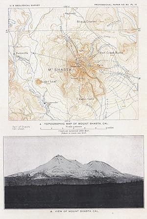
Topographic map of Mount Shasta, Cal. (and) View of Mt. Shasta (photo) (=two pictures on 1 sheet!)
Published by Washington, D.C.: Government Printing Office ,, 1908
Seller: Antiquariat Ruthild J�ger, Lueneburg, Germany
Seller Rating:
Art / Print / Poster
Lithography in three-colour-printing (black, blue and brown) (and photo). 20 x 28 cm (= 7 x 11 in). In very good state of conservation. (from U. S. Geological Survey, 1908). * The precisely engraved map (above) shows the M. Shasta region with Butteville and Berryvale with contour lines and topographical details; (and below:) a photographiv view of Mt. Shasta. (#6088AG).
