Order Total (1 Item Items):
Shipping Destination:

Ukraine Maps Atlas (8 results)
Skip to main search results
Product Type
- All Product Types
- Books (5)
- Magazines & Periodicals
- Comics
- Sheet Music
- Art, Prints & Posters
- Photographs
- Maps (3)
-
Manuscripts &
Paper Collectibles
Condition
- All Conditions
- New
- Used
Binding
Collectible Attributes
- First Edition (3)
- Signed
- Dust Jacket
- Seller-Supplied Images (7)
- Not Printed On Demand
Free Shipping
Seller Location
Seller Rating
-
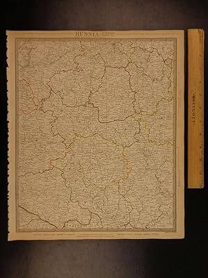
Map of U.S.S.R. Volga, Don, Dnieper , Plate 45 disbound from 1959 Mid-Century Times Atlas of the World, Volume II, (South-West Asia & Russia) Scale 1: 2,500,000. Ukraine, Stalingrad, Moscow, Khar'kov, Kiyev
Published by The Times Publishing Company Ltd., London, 1959
Softcover. Condition: Fine. Dust Jacket Condition: No Dust Jacket. Mid-Century Edition. Single disbound map sheet from 'The Times Atlas of the World, Mid-Century Edition; Volume II Eurasia, suitable for framing. Map is in colour and has vertical centre fold. Approx. sheet size is 49 x 61cm. Sheet is clean, bright and crisp. Scale 1:2,5000,000. Includes parts of Kazakhstan. Map shows relief, S.S.R. boundaries A.S.S.R, Oblast boundaries, cities, town, rivers, main roads, railways, main civil airports and other airfields, canals, marsh and flood areas, salt lakes, salt marshes, blown sand. Key map on reverse and glossary of Russian Geographical Terms and Abbreviations of Principal Soviet Administrative Areas. First printing of this edition. Single sheet map/chart which is suitable for framing and will be shipped rolled and in a cardboard tube. Quantity Available: 1. Shipped Weight: under 1 kg. Pictures of this item not already displayed here available upon request. Inventory No: 45022081078. For International tracked shipping please select the Priority shipping service.
-
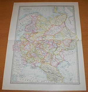
Map of 'Russia in Europe' - Sheet 40 disbound from the 1890 'The Library Reference Atlas of the World' including Finland, Lapland and Poland and modern day Ukraine, Belarus, Latvia, Lithuania, Estonia,Georgia and Azebaijan
Published by Macmillan and Co., London, 1890
First Edition
Softcover. Condition: Very Good. Dust Jacket Condition: No Dust Jacket. First Edition. Single disbound coloured map sheet, from John Bartholomew's Library Reference Atlas. Suitable for framing. Approx size 46 x 35cm, horizontal centre fold. Faint smudges in margin, map is clean, crisp and bright. Sheet covers what was known as 'Russia in Europe' and extends as far east as the Ural Mountains. The mapped area covers what is now Ukraine, Belarus, Latvia, Lithuania, Estonia,Georgia, Azebaijan and part of Russia. Also included are Finland and parts of Norway and Sweden, part of modern Poland, the Black Sea, Constantinople (Istambul), Sea of Azof, Caspian Sea (part), Kara Sea (part), Gulf of Bothnia, Whie Sea, etc. No dust jacket, as published. Quantity Available: 1. Shipped Weight: under 1 kg. Pictures of this item not already displayed here available upon request. Inventory No: 45021014020. For International tracked shipping please select the Priority shipping service.
-
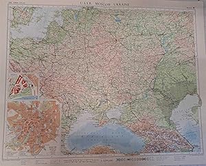
Map of U.S.S.R. Moscow, Ukraine, Plate 46 disbound from 1959 Mid-Century Times Atlas of the World, Volume II, (South-West Asia & Russia) Scale 1: 5,000,000. Inset plans of Moscow 1:100,000 and Kremlin (larger scale)
Published by The Times Publishing Company Ltd., London, 1959
Softcover. Condition: Fine. Dust Jacket Condition: No Dust Jacket. Mid-Century Edition. Single disbound map sheet from 'The Times Atlas of the World, Mid-Century Edition; Volume II Eurasia, suitable for framing. Map is in colour and has vertical centre fold. Approx. sheet size is 49 x 61cm. Sheet is clean, bright and crisp. Scale 1:2,5000,000. Includes Poland, Moldaviya, Lithuania, Latvia, Estonia, Kalingrad and parts of Sweden, Turkey, Armenia, Bulgaria, Romania, Czeckoslovakia. Map shows relief, International Boundaries, S.S.R. boundaries A.S.S.R, Oblast boundaries, cities, town, rivers, main roads, railways, main civil airports and other airfields, canals, oil pipe lines, marsh and flood areas, salt lakes, salt marshes, blown sand. Moscow inset shows stations, parks, road grid, state buildings, hotels, museums etc. Kremlin plan shows buildings, churches and cathedrals, walls and surrounding streets. Key map on reverse and glossary of Russian Geographical Terms and Abbreviations of Principal Soviet Administrative Areas. First printing of this edition. Single sheet map/chart which is suitable for framing and will be shipped rolled and in a cardboard tube. Quantity Available: 1. Shipped Weight: under 1 kg. Pictures of this item not already displayed here available upon request. Inventory No: 45022081079. For International tracked shipping please select the Priority shipping service.
-
1844 BEAUTIFUL Huge Color MAP of Russia Europe Smolensk Ukraine Cossacks ATLAS
Published by London : Published by the Society, and Chapman and Hall, 1844., 1844
Map First Edition
No Binding. Condition: Near Fine. 1st Edition. 1844 BEAUTIFUL Huge Color MAP of Russia Europe Smolensk Ukraine Cossacks ATLAS From Society for Diffusion of Useful Knowledge A beautifully hand-colored map from the 1844 printing of Society for the Diffusion of Useful Knowledge The Society for the Diffusion of Useful Knowledge (SDUK), founded in 1826, and wound up in 1848, was a Whiggish London organisation that published inexpensive texts intended to adapt scientific and similarly high-minded material for the rapidly expanding reading public. It was established mainly at the instigation of Lord Brougham with the objects of publishing information to people who were unable to obtain formal teaching, or who preferred self-education. Engraver: J & C Walker Atlas title: Maps of the Society for the Diffusion of Useful Knowledge. Map title: Russia VI, Smolensk, the Ukraine, to the Don Cossacks. Published: London : Published by the Society, and Chapman and Hall, 1844. Language: English Notes & contents: Originally from the David Rumsey Collection FREE SHIPPING WORLDWIDE Wear: wear as seen in photos Publisher: London : Published by the Society, and Chapman and Hall, 1844. Size: ~13.5in X 16in (33cm x 41cm).
-
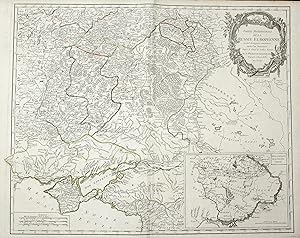
Partie Meridionale de la Russie Europeenne ou sont distinguees exactament toutes le Provinces d'apres le detail de l'Atlas Russien" - Russland Russia Ukraine Krim Crimea Provincen provinces Karte map
Published by Paris, 1776
Seller: Antiquariat Steffen V�lkel GmbH, Seubersdorf, Germany
Seller Rating:

Map
Gro�formatige handkolorierte originalKupferstich-Kartevon ca. 1776 - Blattmasse: ca. 68 x 51 cm - Au�enrand teils leicht fleckig - sonst gut erhalten. -- large handcolored original copper engraved map from around 1776 - slightly stained on the outer margin - otherwise in good condition. || Dies ist ein Original! - Kein Nachdruck! - Keine Kopie! -- This is an original! No copy! - No reprint! Sprache: Franz�sisch Gewicht in Gramm: 1500.
-

Partie Meridionale de la Russie Europ�ene ou sont distingu�es exactement toutes les provinces d'apres le detail de l'Atlas Russien" - Russia Ukraine Black Sea Krim Crimea Russland Karte map
Published by Paris ca. 1750., 1750
Seller: Antiquariat Steffen V�lkel GmbH, Seubersdorf, Germany
Seller Rating:
Map
Originalaltkolorierte Kupferstich-Kartevon ca. 1750. -- Blattmasse: ca. 51 x 67 cm -- im Mittelbug leicht gebr�unt, sonst gut erhalten. || Old colored copper engraved map from ca. 1750. -- slightly browned on the centerfold, otherwise in good condition. Sprache: Franz�sisch Gewicht in Gramm: 35.
-
![Seller image for Geographiicheskij Atlas [For Children, Maps Including Russia And Ukraine] for sale by Arroyo Seco Books, Pasadena, Member IOBA](https://pictures.abebooks.com/inventory/md/md31053122673.jpg)
Geographiicheskij Atlas [For Children, Maps Including Russia And Ukraine]
Published by Izdanie Gosudarstvennai?a? Kartographii Naychno-Technichesk, Leningrad, 1926
Seller: Arroyo Seco Books, Pasadena, Member IOBA, Pasadena, CA, U.S.A.
Association Member: IOBA
Seller Rating:
Book First Edition
Soft cover. Condition: Very Good. Ful Color Plates (illustrator). 1st Edition. 14" X 10 1/2" 10 Atlas Plates In Full Color, Ussr Organization Chart On Plate 11, Contents On Verso Of Xi. Apparently The First And Only Edition, 1926 Date On Front Cover. Wear, Browning, Chip At Upper Right Corner Of Front Cover. A Rare Survival, We Could Not Identify An Institutional Holding.
-

Ukraine on Old Maps: ?????? XV - ????? ???????? XVII ??. (The end of the 15th - the first half of the 17th century). [sold with] From the mid-17th to the second half to the 18th c. Atlas of Reproductions.
Published by 2006; 2009, 2006
Seller: Alexandre Antique Prints, Maps & Books, Toronto, ON, Canada
Seller Rating:

Publisher?s full colour-printed paper boards. Colour-printed paste-on and free endpapers., Text in Polish and English. , Size : Folio., Illustrated. , Volume : 2 volumes. A very good example. Slight edgewear.