
Order Total (1 Item Items):
Shipping Destination:

West India Docks Greenwich (6 results)
Product Type
- All Product Types
- Books (2)
- Magazines & Periodicals
- Comics
- Sheet Music
- Art, Prints & Posters (1)
- Photographs
- Maps (3)
- Manuscripts & Paper Collectibles
Condition
Binding
- All Bindings
- Hardcover
- Softcover (2)
Collectible Attributes
- First Edition
- Signed
- Dust Jacket
- Seller-Supplied Images (5)
- Not Print on Demand (6)
Free Shipping
- Free US Shipping
Seller Location
Seller Rating
-
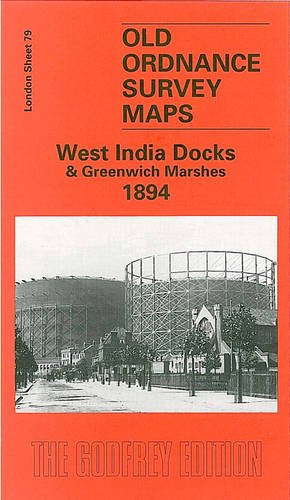
West India Docks and Greenwich Marshes 1894: London Sheet 079.2 (Old O.S. Maps of London)
Published by Alan Godfrey Maps, 2000
ISBN 10: 1841511943ISBN 13: 9781841511948
Book
Paperback. Condition: Very Good. The book has been read, but is in excellent condition. Pages are intact and not marred by notes or highlighting. The spine remains undamaged.
-

West India Docks and Greenwich Marshes 1894: London Sheet 079.2 (Old O.S. Maps of London)
Published by Alan Godfrey Maps, 2000
ISBN 10: 1841511943ISBN 13: 9781841511948
Book
Condition: VeryGood. Most items will be dispatched the same or the next working day.
-

The shah on the Thames: Embarking at the tower for the West India Dock and Greenwich. / England / king / river / Fluss / Schiff / Schifffahrt
Published by London, 1873
Seller: Antiquariat Steffen V�lkel GmbH, Seubersdorf, Germany
Seller Rating:

Art / Print / Poster
Original Holzstich aus einer Zeitschrift von 1873 -- Blatt-Format: ca. 37,5 x 27,5 cm - gut erhalten. - Original wood engraving from a magazine from 1873 - in very good condition. Sprache: Deutsch Gewicht in Gramm: 1550.
-
[Sheet 27 from Bacon's Large-scale Atlas of London and suburbs covering part of South East London including Cubitt Town, Greenwich, Blackwall, North Greenwich Peninsula, West India Docks, Maze Hill]
Publication Date: 1887
Map
Condition: Good. North GREENWICH Peninsula & BLACKWALL Cubitt Town West India Docks c1887 map. Antique colour atlas map; George W. Bacon & Co (c1887). 50.0 x 33.0cm, 19.5 x 13 inches; this is a folding map. Condition: Good. There is nothing printed on the reverse side, which is plain.
-
Sheet 57 from Bacon's 1903 London street atlas covering part of South East London including Cubitt Town, Greenwich, Blackwall, North Greenwich Peninsula, West India Docks, Maze Hill
Publication Date: 1903
Map
Condition: Good. North GREENWICH Peninsula & BLACKWALL Cubitt Town West India Docks 1903 map. Antique colour atlas map; George W. Bacon & Co (1903). 51.0 x 33.5cm, 20 x 13.25 inches; this is a folding map. Condition: Good. The image shown may have been taken from a different example of this map than that which is offered for sale. The map you will receive is in good condition but there may be minor variations in the condition from that shown in the image. There is nothing printed on the reverse side, which is plain.
-

Sheet 57 from Bacon's 1900 London street atlas covering part of South East London including Cubitt Town, Greenwich, Blackwall, North Greenwich Peninsula, West India Docks, Maze Hill
Publication Date: 1900
Map
Condition: Good. North GREENWICH Peninsula & BLACKWALL Cubitt Town West India Docks 1900 map. Antique colour atlas map; George W. Bacon & Co (1900). 51.0 x 33.5cm, 20 x 13.25 inches; this is a folding map. Condition: Good. The image shown may have been taken from a different example of this map than that which is offered for sale. The map you will receive is in good condition but there may be minor variations in the condition from that shown in the image. There is nothing printed on the reverse side, which is plain.
![Seller image for [Sheet 27 from Bacon's Large-scale Atlas of London and suburbs covering part of South East London including Cubitt Town, Greenwich, Blackwall, North Greenwich Peninsula, West India Docks, Maze Hill] for sale by Antiqua Print Gallery](https://pictures.abebooks.com/inventory/md/md31103394502.jpg)
