Order Total (1 Item Items):
Shipping Destination:

World Ocean Atlas Pacific (8 results)
Skip to main search results
Product Type
- All Product Types
- Books (8)
- Magazines & Periodicals
- Comics
- Sheet Music
- Art, Prints & Posters
- Photographs
- Maps
-
Manuscripts &
Paper Collectibles
Condition
- All Conditions
- New
- Used
Binding
Collectible Attributes
- First Edition (3)
- Signed
- Dust Jacket
- Seller-Supplied Images (4)
- Not Printed On Demand
Free Shipping
Seller Location
Seller Rating
-

Pamphlet. Condition: Very Good. 2 Maps, 14 x 10.5 inches, pastel colors, VG.
-
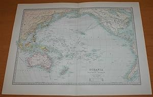
Map of Oceania and the Pacific Ocean - Sheet 80 disbound from the 1890 'The Library Reference Atlas of the World' (including Australia, New Zealand, Hawaii, Philippines, Indonesia, etc.)
Published by Macmillan and Co., London, 1890
First Edition
Softcover. Condition: Very Good. Dust Jacket Condition: No Dust Jacket. First Edition. Single disbound coloured map sheet, from John Bartholomew's Library Reference Atlas. Map covers Oceania and the Pacific from China to America with Austrialasia and the Pacific Islands. Suitable for framing. Approx size 35 x 46cm, vertical centre fold. Occasional faint marks in margin, map is otherwise clean, crisp and bright. Map includes: Australia, New Zealand, Hawaii or Sandwich Islands, Galapogos Islands, Polynesia, East Indain Archipelago, Melanesia, Fiji, Tonga, Papua or New Guinea, Philippines, Borneo, Sumatra, Java, Timor, Japan, Formosa (Taiwan), Yellow Sea, Okhotsk Sea, Berring Sea, Aleutian Islands, and parts of China, Alaska, Canada, USA and South and Central America. No dust jacket, as published. Quantity Available: 1. Shipped Weight: under 1 kg. Pictures of this item not already displayed here available upon request. Inventory No: 45021014023. For International tracked shipping please select the Priority shipping service.
-
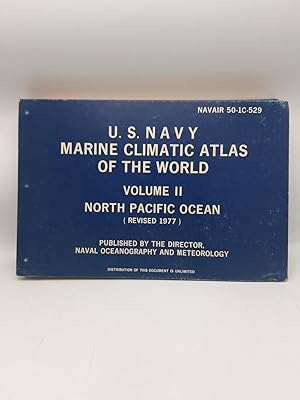
U. S. Navy Marine Climatic Atlas of the World. Volume II. North Pacific Ocean
Published by U. S. Government Printing Office, Washington, 1977
Karten, Tabellen (illustrator). quer gr. 4� XII, 388 S., [Weitere Produktfotos senden wir Ihnen gerne auf Nachfrage]. Opp. Einband etw. berieben. Ecken u. untere, vordere Kante leicht besto�en. Schnitt altersbedingt nachgedunkelt. Der Artikel ist gut erhalten.
-
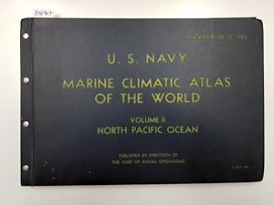
U.S. Marine Climatic Atlas Of The World Volume II: North Pacific Ocean
Published by The Chief of Naval Operations, 1956
Book
8� Leinen. Condition: Sehr gut. XVIII / 275 Charts Ausgetragenes Bibliotheksexemplar, Seiten altersgem�� angedunkelt . Als Versandart w�hlen wir immer eine schnelle Option (in Deutschland Brief oder DHL-Paket, ins Ausland Warenpost oder DHL-Paket). Preis inkl. MwSt. Sprache: Englisch Gewicht in Gramm: 2400.
-

World Ocean Atlas: Pacific Ocean v. 1
Published by Elsevier, 1975
ISBN 10: 0080199992ISBN 13: 9780080199993
Book
hardcover. Condition: Good. Good. book.
-
Hardcover. Condition: Very Good. 1st Edition. 8 Volume Set, filled with all Folding Maps & Illus Plts, 1st 3 Vols by Hawkesworth, 1777, 1st ed; 2nd 2 Vols by Cook, 1777, 1st ed; the last 3 Vols by Cook are the 3rd Ed published in 1785. Entire set Beautifully Bound in Brn Tooled Period Leather with raised Ridges on Spine & Gilt titles, Gilt Marginal Double lines around outside covers & Elaborate interwoven Design around inside covers, Gilt Armorial Design blindstamped on F Covers, Marbled e.p., & Marbled edgepapers, 4to. This set originally came from the Library of Sir Simon R.B. Taylor, Lord Justice of Jamaica, who died in 1815, his bookplate on F e.p. & Gilt Armorial stamped on F Covers. Hinges on front covers of 2 volumes tender else entire set Beautifully Bound & Impressive & in Nice Condition, some foxing but most maps & Illustrations are fresh & appear never to have been opened.
-
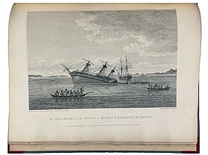
Atlas volume to "A Voyage of Discovery to the North Pacific Ocean, and Round the World."
Published by London: Printed for G. G. and J. Robinson and J. Edwards, 1798., 1798
First Edition
Atlas volume only. Folio (ca 22 4/8 x 18 inches) with 16 engraved maps, charts and coastal profiles (some occasional light soiling to maps, small holes at folds, one or two pale water stains, one small ink spot). Modern half tan calf, grey paper boards, gilt. First edition. Vancouver had served on Captain Cook's second and third voyages and "was made commander of a large-scale expedition to reestablish British rights, resulting from the Nootka Convention, at Nootka Sound; to thoroughly examine the coast south of 60o in order to find a possible passage to the Atlantic; and to learn what other establishments had been founded by other powers. This voyage became one of the most important ever made in the interests of geographical knowledge. Vancouver sailed by way of the Cape of Good Hope to Australia, where he discovered King George's Sound and Cape Hood, then to New Zealand, Hawaii, and the northwest coast of America. Vancouver surveyed the coast of California; visited San Francisco, San Diego. and other Spanish settlements in Alta California. investigated the Strait of Juan de Fuca, discovered the Strait of Georgia; circumnavigated Vancouver Island; and disproved the existence of any passage between the Pacific and Hudson Bay" (Hill). "This is one of the most important voyages for the history and the cartography of the northwest coast in general and of Alaska in particular" (Lada-Mocarski). Hill 1753; Howes V23; Lada-Mocarski 55; Lande 1495; NMM 142; Sabin 98443; Staton & Tremaine/TPL 688; Streeter sale VI:3497 (this copy); Wagner I, pp.239-50. For more information about this book, or a warm welcome to see it and other books in our library at 72nd Street, NYC, please contact Kate Hunter, M.A. Oxon, in the Rare Book Department.
-
A Voyage of Discovery to the North Pacific Ocean, and Round the World; in which the Coast of North-West America has been Carefully Examined and Accurately Surveyed. Undertaken by his Majesty's Command, Principally with a View to Ascertain the Existence of any Navigable Communication between the North Pacific and North Atlantic Oceans; and Performed in the Years 1790, 1791, 1792, 1793, 1794, and 1795, in the Discovery Sloop of War, and Armed Tender Chatham, under the Command of Captain George Vancouver. Volumes I-III plus Atlas
Published by Printed for G. G. and J. Robinson, Paternoster-Row; and J. Edwards, Pall-Mall, London, 1798
Seller: Donald A. Heald Rare Books (ABAA), New York, NY, U.S.A.
Seller Rating:

4 volumes (including atlas). 4to (11 3/4 x 9 1/4 inches) and folio (22 1/2 x 17 1/2 inches). Vol. I: [8] [i]-xxix [9] [1]-432. 478 pp. 6 engraved plates by W. Alexander after H. Humphries. Vol. II: [10] [1]-504. 514 pp. 5 engraved plates by W. Alexander after T. Heddington and F. Sykes. Vol. III: [10] [1]-505 [3]. 516 pp. 6 engraved plates by W. Alexander after J. Sykes, et al. Atlas: 10 engraved folding charts, 6 engraved plates of coastal profiles, uncut, mounted on guards throughout. Half-Titles, Titles, Dedication, Introduction, Editor's Advertisement, Table of Contents, List of Plates, Books I-VI, Notes and Miscellaneous Observations, Errata. Finely bound to style in uniform red quarter morocco with tips on original grey paper boards, spine gilt-ruled into six compartments, title and volume number in gilt in second and fourth compartments, all edges sprinkled grey. Atlas with binder's ticket of "J. Tuck, Bookbinder" "One of the most important [voyages] ever made in the interests of geographical knowledge." - Hill This work, considered by Cowan to be "superior to any of its kind," documents Vancouver's voyage, which resulted in the first published map to depict Hawaii in its entirety. [Fitzpatrick] Vancouver had been put in command of the expedition related in this work on the recommendation of his old commanding officer Alan Gardner. He had served earlier with both Admiral Rodney and on James Cook's second and third voyages, so he was well experienced in addition to being a first-class navigator. Vancouver's voyage was mounted as a "grand-scale expedition to reclaim Britain's rights, resulting from the Nootka Convention, at Nootka Sound, to thoroughly examine the coast south of 60� in order to find a possible passage to the Atlantic; and to learn what establishments had been founded by other powers. Vancouver sailed by way of the Cape of Good Hope to Australia, where he discovered King George's Sound and Cape Hood, then to New Zealand, Hawaii, and the northwest coast of America. In three seasons' work Vancouver surveyed the coast of California; visited San Francisco and San Diego; and other Spanish settlements in Alta California; settled the necessary formalities with the Spanish at Nootka; investigated the Strait of Juan de Fuca; discovered the Strait of Georgia; circumnavigated Vancouver Island; and disproved the existence of any passage between the Pacific and Hudson Bay." [Hill] Cowan (1914), p.236; Cowan (1933), 654-655 pp. Cox II, p.30. DNB. Ferguson I, 281. Fitzpatrick, Early Mapping of Hawaii, 39-43 pp. Forbes I, 298. Graff, Western Americana 4456. Hill 1753. Howes V-23. JCB 2009. Jones, Americana 667. Judd 178. Lada-Mocarski 55. Lande 1495. National Maritime Museum 142. O'Reilly-Reitman 635. Sabin 98443. Smith, Pacific Northwest Americana 10469. Staton and Tremaine 688. Strathern 582. Streeter Sale 3497. Tweney 78. Wagner, Cartography of the Northwest Coast, 853-860 pp. Wantrup 63a. Wickersham 6601. Zamorano, Eighty 77.