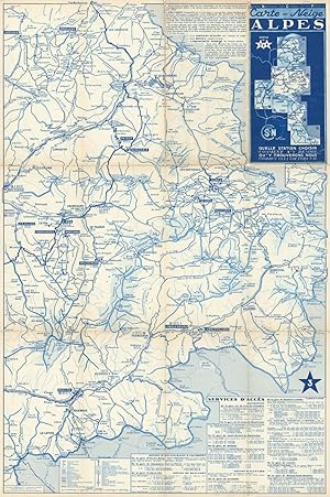
Carte-Neige Alpes Nos. 3 & 4
Barreau, J. et Cie.
From
Antiqua Print Gallery, London, United Kingdom
Seller rating 4 out of 5 stars
![]()
AbeBooks Seller since January 14, 2022
About this Item
Description:
"SNCF Carte-Neige Alpes #3-4 Savoie Ski resorts map Tignes Courchevel Isère 1939. Mid 20th century folding railway map of the ski resorts of the French Alps; Copyright J. Barreau et Cie. (1939). 50.0 x 75.0cm, 19.5 x 29.5 inches; this is a folding map. Condition: Good. The map is overprinted with "Important - This is pre-war publication and information given regarding cheap fares, bus services, hotels, sports facilities, etc… may no longer apply". There is another map printed on the reverse side. Map 3 and Map 4 are printed on opposite sides of the sheet. Map 3 includes Courchevel, Tignes & Val d'Isère. Map 4 includes Valloire, St Martin-de-Belleville, St Sorlin d'Arves, St Jean d'Arves". Seller Inventory # P-6-107239
Bibliographic Details
Title: Carte-Neige Alpes Nos. 3 & 4
Publication Date: 1939
Condition: Good
AbeBooks offers millions of new, used, rare and out-of-print books, as well as cheap textbooks from thousands of booksellers around the world. Shopping on AbeBooks is easy, safe and 100% secure - search for your book, purchase a copy via our secure checkout and the bookseller ships it straight to you.
Search thousands of booksellers selling millions of new & used books
New & Used Books
New and used copies of new releases, best sellers and award winners. Save money with our huge selection.
Rare & Out of Print Books
From scarce first editions to sought-after signatures, find an array of rare, valuable and highly collectible books.


