


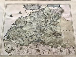
MAP OF THE MIDDLE PART OF GALLOWAY, SCOTLAND
BLAEU, JOHANNES
Published by J. BLAEU CIRCA 1654, 1654
Used
No Binding
From
Elder Books, Ross on Wye, Herefordshire, United Kingdom
Seller rating 5 out of 5 stars
![]()
AbeBooks Seller since September 25, 2009
This specific copy is no longer available. Here are our closest matches for MAP OF THE MIDDLE PART OF GALLOWAY, SCOTLAND.
About this Item
Description:
AN ORIGINAL MID 17TH CENTURY MAP OF SOUTH WEST SCOTLAND WITH EARLY HAND COLOURING, MAP MEASURES APPROX 21 x 17 INCHES & 25 x 22 INCHES WITH MARGINS. CENTRE FOLD AS PUBLISHED,SOME LIGHT BROWNING OR OFFSETTING TO MAP, OVERALL IN VERY GOOD CONDITION. MAP IS IN A REMOVABLE PLASTIC BAG AND DOES SHOW SOME REFLECTIONS IN IMAGES. EXTRA POSTAGE COSTS MAY APPLY TO OVERSEAS ORDERS. Seller Inventory # 150
Bibliographic Details
Title: MAP OF THE MIDDLE PART OF GALLOWAY, SCOTLAND
Publisher: J. BLAEU CIRCA 1654
Publication Date: 1654
Binding: No Binding
Condition: Very Good
Top Search Results from the AbeBooks Marketplace

1654 GALLOVIDIAE PAR MEDIA Middle part of GALLOWAY Scotland Map by BLAEU
Used
Seller: Antique Paper Company, ASHFORD, KENT, United Kingdom
Seller rating 2 out of 5 stars
![]()
1654A large original copper engraved map titledGALLOVIDIA PARS MEDIA que Deam et Cream - The Middle part of GallowayA very fine example of this rare map showingthe middle region of Galloway, oriented to the north. German text on verso.Excellent condition with central fold as issued and later hand colouring.Approx 60cmx 49cmincluding margins.Joan (Johannes) Blaeu (1596-1673) was a Dutch cartographer active in the 17th Century. Joan was the son of Willem Janszoon Blaeu, founder of the Blaeu firm. Like his farther Willem, Johannes was born in Aklmaar, North Holland, He studied law, attaining a doctorate, before moving to Amsterdam to join the family mapmaking business. In 1633, Willem arranged for Johannes to take over Hessel Gerritszs position as the official chartmaker of the Dutch East India Company, although little is known of his work for that organisation, which was by contract and oath secretive. Where other cartographers often fell into financial ruin, the Blaeu form thrived. It was most likely those profits that allowed the firm to publish the Theatrum Orbis Terrarum, Altlas Novus, their most significant and best known publication. When Willem Blaeu died in 1638, Johannes, along with this Borther Cornelius (1616-1648) took over the management of the Blaeu firm. In 1662, Joan and Cornelius produced a vastly expanded and updated work, theAtlas Novus, whose handful of editions ranged from 9 to 12 volumes. In 1672 the Great Amsterdam Fire destroyed their offices and most of their printing plates. Johannes Blaeu diedthe following year. Johannes Blaeu was survived by his son, also Johannes but commonly called Joan II, who inherited the familys VOC contract, for whom he compiled maps until 1712.Antique Paper Company are a long established family business selling original antique prints, maps engravings as well as many other paper antiques such as original vintage Decorative Posters, Ephemera, Stamps Postal History, Manuscripts, Antiquarian Books much more. We are always looking to buy and have substantial immediate funds available. We are looking for exceptional single items, better collections, original archives, Atlases, Libraries, accumulations etc and have previously purchased from Major Institutions, Libraries, Collectors, Solicitors many other sources. We are happy to travel almost anywhere in the world for the right opportunities. So please do get in touch if you are considering selling your Antique Paper collectables. Seller Inventory # GALLOVIDIAE-5101038
Quantity: 1 available
1654 GALLOVIDIAE PAR MEDIA Middle part of GALLOWAY Scotland Map by BLAEU
Used
Seller: Antique Paper Company, ASHFORD, KENT, United Kingdom
Seller rating 2 out of 5 stars
![]()
1654A large original copper engraved map titledGALLOVIDIA PARS MEDIA que Deam et Cream - The Middle part of GallowayA very fine example of this rare map showingthe middle region of Galloway, oriented to the north. Germantext on verso.Excellent condition with central fold as issued and later hand colouring.Approx 48cmx 56cm including the margins.Joan (Johannes) Blaeu (1596-1673) was a Dutch cartographer active in the 17th Century. Joan was the son of Willem Janszoon Blaeu, founder of the Blaeu firm. Like his farther Willem, Johannes was born in Aklmaar, North Holland, He studied law, attaining a doctorate, before moving to Amsterdam to join the family mapmaking business. In 1633, Willem arranged for Johannes to take over Hessel Gerritszs position as the official chartmaker of the Dutch East India Company, although little is known of his work for that organisation, which was by contract and oath secretive. Where other cartographers often fell into financial ruin, the Blaeu form thrived. It was most likely those profits that allowed the firm to publish the Theatrum Orbis Terrarum, Altlas Novus, their most significant and best known publication. When Willem Blaeu died in 1638, Johannes, along with this Borther Cornelius (1616-1648) took over the management of the Blaeu firm. In 1662, Joan and Cornelius produced a vastly expanded and updated work, theAtlas Novus, whose handful of editions ranged from 9 to 12 volumes. In 1672 the Great Amsterdam Fire destroyed their offices and most of their printing plates. Johannes Blaeu diedthe following year. Johannes Blaeu was survived by his son, also Johannes but commonly called Joan II, who inherited the familys VOC contract, for whom he compiled maps until 1712.Antique Paper Company are a long established family business selling original antique prints, maps engravings as well as many other paper antiques such as original vintage Decorative Posters, Ephemera, Stamps Postal History, Manuscripts, Antiquarian Books much more. We are always looking to buy and have substantial immediate funds available. We are looking for exceptional single items, better collections, original archives, Atlases, Libraries, accumulations etc and have previously purchased from Major Institutions, Libraries, Collectors, Solicitors many other sources. We are happy to travel almost anywhere in the world for the right opportunities. So please do get in touch if you are considering selling your Antique Paper collectables. Seller Inventory # GALLOVIDIAE-5101032
Quantity: 1 available