Items related to Texas Land Survey Maps for Bastrop County
Synopsis
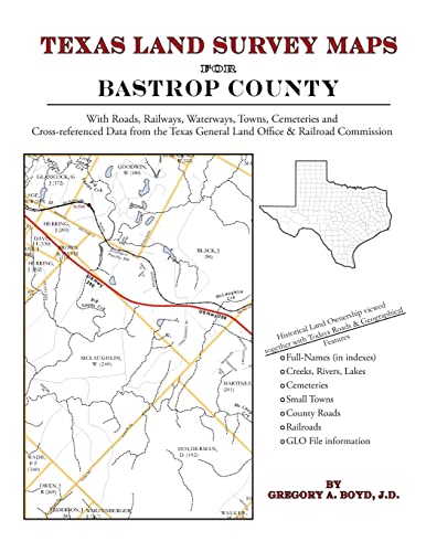
156 pages with 59 maps An indispensable book for any researcher interested in Bastrop County's history or land (or both), or its first landowners after Texas's Independence from Mexico. Each book in this series is laid out into multiple maps using a 6 mile high by 4 mile wide grid.This book contains 54 Survey maps laid out within this grid. Each Land Survey Map shows the boundaries of original parcels laid out over existing roads, railroads, waterways. These are shown as well as the original Survey-Name and the Abstract Number assigned by the Texas General Land Office to the instrument that gave ownership to that parcel. Here are a number of details about our Bastrop County book . . . Supplemental Maps Included (in addition to the primary Survey Maps) . . . - Where Bastrop County Lies Within the State (Map A) - Bastrop County and its Surrounding Counties (Map B) - An Index Map showing where each of the Land Survey Maps are within Bastrop County (Map C) - An Index Map that builds upon Map C and shows the community-center points in relationship to the county-grid (Map D) - An Index Map that builds upon Map C and shows cemeteries listed in the USGS database in relationship to the county-grid (Map E) Primary Indexes (apart from each Survey-Map's own index of survey-names) - An All-Name Index (alphabetical by last-name) for every person mentioned in the maps, utilizing both Texas General Land Office and Texas Railroad Commission data. - The Abstract Listing: this is where you find the real details behind each parcel of land.Items are listed by Abstract Number What Cities and Towns are in Bastrop County, Texas (and in this book)? Alum Creek, Bastrop, Bateman, Butler, Camp Swift, Cedar Creek, Clearview, Colorado, Elgin, Elysium, Flower Hill, Grassyville, Hills Prairie, Jeddo, Jordan, Kovar, McDade, Paige, Phelan, Pin Oak, Pleasant Grove (historical), Red Rock, Rockne, Rosanky, Salem, Sayersville, Shiloh (historical), Smithville, String Prairie, Swiftex, Togo, Upton, Utley, Watterson, Willman, Wyldwood
"synopsis" may belong to another edition of this title.
- PublisherArphax Publishing Co.
- Publication date2010
- ISBN 10 1420350854
- ISBN 13 9781420350852
- BindingPaperback
- LanguageEnglish
- Number of pages164
Other Popular Editions of the Same Title

Search results for Texas Land Survey Maps for Bastrop County

Seller Image
Texas Land Survey Maps for Bastrop County
Seller: GreatBookPrices, Columbia, MD, U.S.A.
Seller rating 4 out of 5 stars
![]()
Condition: New. Seller Inventory # 21017292-n
Quantity: Over 20 available
Seller Image
Texas Land Survey Maps for Bastrop County (Paperback or Softback)
Published by
Arphax Publishing Co. 5/20/2010, 2010
ISBN 10: 1420350854
ISBN 13: 9781420350852
New
Paperback or Softback
Seller: BargainBookStores, Grand Rapids, MI, U.S.A.
Seller rating 5 out of 5 stars
![]()
Paperback or Softback. Condition: New. Texas Land Survey Maps for Bastrop County 0.88. Book. Seller Inventory # BBS-9781420350852
Quantity: 5 available
Stock Image
Texas Land Survey Maps for Bastrop County
Seller: Lucky's Textbooks, Dallas, TX, U.S.A.
Seller rating 5 out of 5 stars
![]()
Condition: New. Seller Inventory # ABLING22Oct2817100015346
Quantity: Over 20 available
Stock Image
Texas Land Survey Maps for Bastrop County
Print on DemandSeller: California Books, Miami, FL, U.S.A.
Seller rating 5 out of 5 stars
![]()
Condition: New. Print on Demand. Seller Inventory # I-9781420350852
Quantity: Over 20 available
Seller Image
Texas Land Survey Maps for Bastrop County
Seller: GreatBookPrices, Columbia, MD, U.S.A.
Seller rating 5 out of 5 stars
![]()
Condition: As New. Unread book in perfect condition. Seller Inventory # 21017292
Quantity: Over 20 available
Stock Image
Texas Land Survey Maps for Bastrop County
Seller: Russell Books, Victoria, BC, Canada
Seller rating 4 out of 5 stars
![]()
paperback. Condition: New. Special order direct from the distributor. Seller Inventory # ING9781420350852
Quantity: Over 20 available
Stock Image
Texas Land Survey Maps for Bastrop County
Published by
Arphax Publishing Co., 2010
ISBN 10: 1420350854
ISBN 13: 9781420350852
New
Paperback / softback
Seller: THE SAINT BOOKSTORE, Southport, United Kingdom
Seller rating 5 out of 5 stars
![]()
Paperback / softback. Condition: New. This item is printed on demand. New copy - Usually dispatched within 5-9 working days 399. Seller Inventory # C9781420350852
Quantity: Over 20 available
Seller Image
Texas Land Survey Maps for Bastrop County
Seller: GreatBookPricesUK, Woodford Green, United Kingdom
Seller rating 5 out of 5 stars
![]()
Condition: New. Seller Inventory # 21017292-n
Quantity: Over 20 available
Seller Image
Texas Land Survey Maps for Bastrop County
Seller: GreatBookPricesUK, Woodford Green, United Kingdom
Seller rating 5 out of 5 stars
![]()
Condition: As New. Unread book in perfect condition. Seller Inventory # 21017292
Quantity: Over 20 available