Items related to Colorado Trail Pocket Map

Major Update for 2018
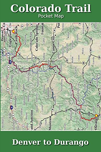
The Colorado Trail Pocket Map is a complete and concise set of topographic maps created with digitized base maps covering every step of the 486 mile trail from Denver, CO to Durango, CO.
The land cover, hydrology and contour data used to create these maps has been collected within the last 5 years, presented in a completely uniform manner across all 74 maps. No other complete Colorado Trail map set available can say this!
Features:
+ Seamless. Uniform styles, colors, fonts and unit of measure.
+ 74 full color, digitized topographic maps
+ 10 distinct land cover shades for easily identifying terrain
+ Easily see road walks, dirt and paved
+ Beautiful 3D hill shading
+ Highly detailed elevation chart on each map
+ 6" x 9" (15.2cm x 22.9cm) format for easy pack stowage
+ Accumulated trail mileage every mile
+ Resupply locations within 90 miles of map center
+ 1:38,500 scale with decimal degree lat/long and UTM grids
+ Trail trace from ColoradoTrail.org
+ Maps extend to edge of paper
+ Clear overlap with Continental Divide Trail (magenta color)
These 6" x 9" full color topographic maps are designed to stow easily into your pack, without sacrificing the detail required by a hiker in the back country.
"synopsis" may belong to another edition of this title.
- PublisherCreateSpace Independent Publishing Platform
- Publication date2011
- ISBN 10 1468029053
- ISBN 13 9781468029055
- BindingPaperback
- Number of pages94
Buy New
Learn more about this copy
US$ 20.12
Shipping:
US$ 4.00
Within U.S.A.
Top Search Results from the AbeBooks Marketplace
Stock Image
Colorado Trail Pocket Map
Published by
CreateSpace Independent Publishing Platform
(2011)
ISBN 10: 1468029053
ISBN 13: 9781468029055
New
Paperback
Quantity: 1
Seller:
Rating
Book Description Paperback. Condition: new. New. Fast Shipping and good customer service. Seller Inventory # Holz_New_1468029053
Buy New
US$ 20.12
Convert currency
Stock Image
Colorado Trail Pocket Map
Published by
Createspace
(2011)
ISBN 10: 1468029053
ISBN 13: 9781468029055
New
Paperback
Quantity: 1
Seller:
Rating
Book Description Paperback. Condition: Brand New. 96 pages. 9.00x6.00x0.23 inches. This item is printed on demand. Seller Inventory # zk1468029053
Buy New
US$ 36.21
Convert currency
Stock Image
Colorado Trail Pocket Map
Published by
CreateSpace Independent Publis
(2011)
ISBN 10: 1468029053
ISBN 13: 9781468029055
New
Paperback
Quantity: 2
Seller:
Rating
Book Description Paperback. Condition: New. Brand New!. Seller Inventory # VIB1468029053
Buy New
US$ 59.16
Convert currency
Stock Image
Colorado Trail Pocket Map
Published by
CreateSpace Independent Publishing Platform
(2011)
ISBN 10: 1468029053
ISBN 13: 9781468029055
New
Paperback
Quantity: 1
Seller:
Rating
Book Description Paperback. Condition: new. Brand New Copy. Seller Inventory # BBB_new1468029053
Buy New
US$ 69.06
Convert currency