Items related to Yellowstone Lake: Yellowstone National Park SE Map...
Yellowstone Lake: Yellowstone National Park SE Map (National Geographic Trails Illustrated Map, 305)
Synopsis
� Waterproof � Tear-Resistant � Topographic Map
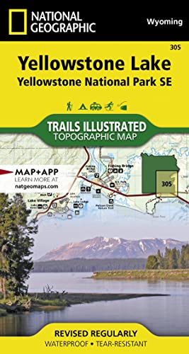
National Geographic's Trails Illustrated map of the Yellowstone Lake area of Yellowstone National Park is designed to meet the needs of outdoor enthusiasts with unmatched detail of the south-east section of the national park. Expertly researched and created in partnership with local land management agencies, this map features key points of interest including Yellowstone lake shown with contours and bathe metric shading, Lake Village, Grant Village, East Entrance Station, Heart Lake, Bridger-Teton National Forest, Shoshone National Forest, Teton Wilderness, and North Absaroka Wilderness.
With many miles of mapped trails and marked Bear Management Zones the Yellowstone Lake map can guide you off the beaten path and back again. The clearly marked trails include mileages between intersections. The map base includes contour lines and elevations for summits, passes and many lakes. Some of the many recreation features include: visitor centers, campgrounds, boat ramps, trailheads, and interpretive trails.
Every Trails Illustrated map is printed on "Backcountry Tough" waterproof, tear-resistant paper. A full UTM grid is printed on the map to aid with GPS navigation.
Other features found on this map include: Big Game Ridge, Colter Peak, Eagle Peak, Heart Lake, Lewis Lake, Mount Hancock, Mount Sheridan, North Absaroka Wilderness, Red Mountains, Shoshone National Forest, Teton National Forest, Teton Wilderness, Thorofare Plateau, Washakie Wilderness, Yellowstone Lake, Yellowstone National Park.
- Map Scale = 1:70,000
- Sheet Size = 37.75" x 25.5"
- Folded Size = 4" x 7.5"
"synopsis" may belong to another edition of this title.
About the Author
Founded in 1915 as the Cartographic Group, the first division of National Geographic, National Geographic Maps has been responsible for illustrating the world around us through the art and science of mapmaking.Today, National Geographic Maps continues this mission by creating the world's best wall maps, recreation maps, atlases, and globes which inspire people to care about and explore their world.
"About this title" may belong to another edition of this title.
- PublisherNational Geographic Maps
- Publication date2019
- ISBN 10 1566954363
- ISBN 13 9781566954365
- BindingMap
- LanguageEnglish
- Number of pages2
Buy New
View this item
US$ 17.64
Shipping:
US$ 4.25
From United Kingdom to U.S.A.
Search results for Yellowstone Lake: Yellowstone National Park SE Map...
Stock Image
Yellowstone National Park SE Map: Trails Illustrated National Parks (National Geographic Trails Illustrated Map)
Published by
National Geographic Maps, 2019
ISBN 10: 1566954363
ISBN 13: 9781566954365
Used
Paperback
Seller: WorldofBooks, Goring-By-Sea, WS, United Kingdom
Seller rating 4 out of 5 stars
![]()
Paperback. Condition: Fine. Seller Inventory # GOR011805515
Quantity: 1 available
Stock Image
Yellowstone National Park SE Map: Trails Illustrated National Parks (National Geographic Trails Illustrated Map)
Published by
National Geographic Maps, 2019
ISBN 10: 1566954363
ISBN 13: 9781566954365
Used
Paperback
Seller: WorldofBooks, Goring-By-Sea, WS, United Kingdom
Seller rating 4 out of 5 stars
![]()
Paperback. Condition: Very Good. The book has been read, but is in excellent condition. Pages are intact and not marred by notes or highlighting. The spine remains undamaged. Seller Inventory # GOR014162041
Quantity: 1 available
Stock Image
Yellowstone SE/Yellowstone Lake
Seller: PBShop.store UK, Fairford, GLOS, United Kingdom
Seller rating 5 out of 5 stars
![]()
UNK. Condition: New. New Book. Shipped from UK. Established seller since 2000. Seller Inventory # EA-9781566954365
Quantity: 2 available
Stock Image
Yellowstone Lake: Yellowstone National Park SE (National Geographic Trails Illustrated Map, 305)
Seller: SecondSale, Montgomery, IL, U.S.A.
Seller rating 5 out of 5 stars
![]()
Condition: Good. Item in good condition. Textbooks may not include supplemental items i.e. CDs, access codes etc. Seller Inventory # 00043242740
Quantity: 6 available
Stock Image
Yellowstone SE/Yellowstone Lake
Seller: PBShop.store US, Wood Dale, IL, U.S.A.
Seller rating 5 out of 5 stars
![]()
UNK. Condition: New. New Book. Shipped from UK. Established seller since 2000. Seller Inventory # EA-9781566954365
Quantity: 2 available
Stock Image
Yellowstone Se/yellowstone Lake: Trails Illustrated National Parks
Seller: THE SAINT BOOKSTORE, Southport, United Kingdom
Seller rating 5 out of 5 stars
![]()
Sheet map, folded. Condition: New. New copy - Usually dispatched within 4 working days. 98. Seller Inventory # B9781566954365
Quantity: 2 available
Stock Image
National Geographic Trails Illustrated Map Yellowstone Se / Yellowstone Lake: Wyoming
Seller: Revaluation Books, Exeter, United Kingdom
Seller rating 5 out of 5 stars
![]()
Map. Condition: Brand New. map edition. 2 pages. 0.25x9.25x4.25 inches. In Stock. Seller Inventory # 1566954363
Quantity: 1 available