Items related to Santa Fe, Truchas Peak Map (National Geographic Trails...
Synopsis
� Waterproof � Tear-Resistant � Topographic Map
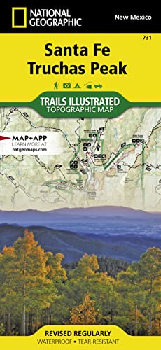
National Geographic's Trails Illustrated map of the Truchas Peak and Santa Fe was designed for all outdoor enthusiasts enjoying the recreational opportunities around Santa Fe. Expertly researched and created in cooperation with the U.S. Forest Service and others, the map covers the area's wide range of public recreation lands with unparalleled detail. Coverage includes Santa Fe and Carson National Forests; Pecos Wilderness, River and National Historical Park; Picuris, Nambe, Tesuque Pueblos; Morphy Lake and Hyde Memorial State Parks; Santa Fe Canyon Preserve; and Open Space Parks.
Get off the beaten bath and back on again by following the map along clearly mapped trails, shown with mileage markers and colored for motorized or non-motorized use, including the area's National Recreation Trails. Your navigation will be aided by the map's contour lines, elevations, labeled peaks and summits, water features, numbered Forest Service roads and clear color-coded boundaries for different land designations. Those preferring to explore by road will find the El Camino Real, Santa Fe Trail, Historic Route 66 and High Road to Taos Scenic Byways, all shown with their roadside points of interest. Other recreation features include trailheads, interpretive trails, campgrounds, RV campgrounds and dump stations, cross-country ski trails, alpine ski areas, boat ramps, canoe and fishing areas, lookout towers and scenic viewpoints.
Every Trails Illustrated map is printed on "Backcountry Tough" waterproof, tear-resistant paper. A full UTM grid is printed on the map to aid with GPS navigation.
Other features found on this map include: Carson National Forest, Pecos National Historical Park, Pecos Wilderness, Rincon Mountains, Santa Fe, Santa Fe Baldy, Santa Fe National Forest, Truchas Peak.
- Map Scale = 1:63,360
- Sheet Size = 37.75" x 25.5"
- Folded Size = 4.25" x 9.25"
"synopsis" may belong to another edition of this title.
About the Author
Founded in 1915 as the Cartographic Group, the first division of National Geographic, National Geographic Maps has been responsible for illustrating the world around us through the art and science of mapmaking.Today, National Geographic Maps continues this mission by creating the world's best wall maps, recreation maps, atlases, and globes which inspire people to care about and explore their world.
"About this title" may belong to another edition of this title.
- PublisherNatl Geographic Society Maps
- Publication date2019
- ISBN 10 1566956773
- ISBN 13 9781566956772
- BindingMap
- LanguageEnglish
- Number of pages2
Buy New
View this item
US$ 36.87
Shipping:
US$ 4.33
From United Kingdom to U.S.A.
Search results for Santa Fe, Truchas Peak Map (National Geographic Trails...
Stock Image
Santa Fe, Truchas Peak
Seller: PBShop.store UK, Fairford, GLOS, United Kingdom
Seller rating 4 out of 5 stars
![]()
UNK. Condition: New. New Book. Shipped from UK. Established seller since 2000. Seller Inventory # EA-9781566956772
Quantity: 3 available
Seller Image
Santa Fe, Truchas Peak Map
Seller: BuchWeltWeit Ludwig Meier e.K., Bergisch Gladbach, Germany
Seller rating 5 out of 5 stars
![]()
Karte. Condition: Neu. Neuware -National Geographic's Trails Illustrated Maps are the most detailed and up-to-date topographic recreation maps available for US National Parks, National Forests and other popular outdoor recreation areas. A necessity for exploring the outdoors, each map is printed on waterproof, tear-resistant material. They also contain key safety and contact information, GPS and compass coordinates, Leave No Trace ethical guidelines and hundreds of points-of-interest, including scenic viewpoints, campgrounds, boat launches, swimming areas, marine sanctuaries and wildlife refuges. 2 pp. Englisch. Seller Inventory # 9781566956772
Quantity: 1 available
Seller Image
Santa Fe, Truchas Peak Map
Seller: Rheinberg-Buch Andreas Meier eK, Bergisch Gladbach, Germany
Seller rating 5 out of 5 stars
![]()
Karte. Condition: Neu. Neuware -National Geographic's Trails Illustrated Maps are the most detailed and up-to-date topographic recreation maps available for US National Parks, National Forests and other popular outdoor recreation areas. A necessity for exploring the outdoors, each map is printed on waterproof, tear-resistant material. They also contain key safety and contact information, GPS and compass coordinates, Leave No Trace ethical guidelines and hundreds of points-of-interest, including scenic viewpoints, campgrounds, boat launches, swimming areas, marine sanctuaries and wildlife refuges. 2 pp. Englisch. Seller Inventory # 9781566956772
Quantity: 1 available
Stock Image
Santa Fe, Truchas Peak
Seller: PBShop.store US, Wood Dale, IL, U.S.A.
Seller rating 5 out of 5 stars
![]()
UNK. Condition: New. New Book. Shipped from UK. Established seller since 2000. Seller Inventory # EA-9781566956772
Quantity: 3 available
Stock Image
National Geographic Santa Fe, Truchas Peak Map: Trails Illustrated
Seller: Revaluation Books, Exeter, United Kingdom
Seller rating 5 out of 5 stars
![]()
Map. Condition: Brand New. fol map il edition. 2 pages. 9.25x4.25x0.10 inches. In Stock. Seller Inventory # 1566956773
Quantity: 1 available
Seller Image
Santa Fe, Truchas Peak Map
Seller: AHA-BUCH GmbH, Einbeck, Germany
Seller rating 5 out of 5 stars
![]()
Karte. Condition: Neu. Neuware - National Geographic's Trails Illustrated Maps are the most detailed and up-to-date topographic recreation maps available for US National Parks, National Forests and other popular outdoor recreation areas. A necessity for exploring the outdoors, each map is printed on waterproof, tear-resistant material. They also contain key safety and contact information, GPS and compass coordinates, Leave No Trace ethical guidelines and hundreds of points-of-interest, including scenic viewpoints, campgrounds, boat launches, swimming areas, marine sanctuaries and wildlife refuges. Seller Inventory # 9781566956772
Quantity: 1 available
Seller Image
Santa Fe, Truchas Peak
Seller: moluna, Greven, Germany
Seller rating 5 out of 5 stars
![]()
Condition: New. National Geographic s Trails Illustrated Maps are the most detailed and up-to-date topographic recreation maps available for US National Parks, National Forests and other popular outdoor recreation areas. A necessity for exploring the outdoors, each map is . Seller Inventory # 27368781
Quantity: 1 available