Items related to National Geographic Cuba Wall Map - Classic (Poster...
National Geographic Cuba Wall Map - Classic (Poster Size: 36 x 24 in) (National Geographic Reference Map)
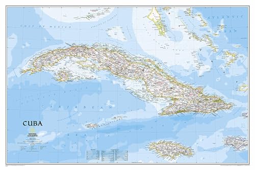

National Geographic's signature Classic style map of Cuba uses a bright and vibrant color palette featuring stunning shaded relief and ocean bathymetry. Pinpointed on the map are thousands of cities and towns, national parks, mountains, swamps, coral reefs and islands of the archipelago. In addition, major infrastructure networks are displayed, including highways, roads, railroads, oil fields and pipelines, airports, canals and ferry routes. Jamaica, the Cayman Islands, the Florida Keys, and most of the Bahamas and Haiti are shown, along with the Gulf of Mexico, Caribbean Sea, Atlantic Ocean and Straits of Florida. A user friendly index shows the English translation for many geographic terms.
The map is packaged in a two inch diamater clear plastic tube. The tube has a decorative label showing a thumbnail of the map with dimensions and other pertinent information.
- Map Scale = 1:1,500,000
- Sheet Size = 36" x 24"
"synopsis" may belong to another edition of this title.
About the Author:
Founded in 1915 as the Cartographic Group, the first division of National Geographic, National Geographic Maps has been responsible for illustrating the world around us through the art and science of mapmaking.Today, National Geographic Maps continues this mission by creating the world's best wall maps, recreation maps, atlases, and globes which inspire people to care about and explore their world.
"About this title" may belong to another edition of this title.
- PublisherNatl Geographic Society Maps
- Publication date2013
- ISBN 10 1597754374
- ISBN 13 9781597754378
- BindingMap
- Number of pages1
Buy New
Learn more about this copy
US$ 25.93
Shipping:
FREE
Within U.S.A.
Top Search Results from the AbeBooks Marketplace
Stock Image
National Geographic: Cuba Classic Wall Map (36 x 24 inches) (National Geographic Reference Map)
Published by
National Geographic Maps
(2013)
ISBN 10: 1597754374
ISBN 13: 9781597754378
New
Quantity: 1
Seller:
Rating
Book Description Map. Condition: New. Seller Inventory # DADAX1597754374
Buy New
US$ 25.93
Convert currency
Stock Image
Cuba Classic: Wall Maps Countries & Regions
Published by
Natl Geographic Society Maps
(2011)
ISBN 10: 1597754374
ISBN 13: 9781597754378
New
Quantity: 1
Seller:
Rating
Book Description Map. Condition: Brand New. rol map edition. 1 pages. 25.00x2.00x2.00 inches. In Stock. Seller Inventory # 1597754374
Buy New
US$ 40.88
Convert currency