
AN AMERICAN LOG-HOUSE [caption title]
[Collot, Georges Henri Victor]
Published by [Paris, 1826
Used
From
William Reese Company - Americana, New Haven, CT, U.S.A.
Seller rating 4 out of 5 stars
![]()
AbeBooks Seller since July 13, 2006
This specific copy is no longer available. Here are our closest matches for AN AMERICAN LOG-HOUSE [caption title] by [Collot, Georges Henri Victor].
About this Item
Description:
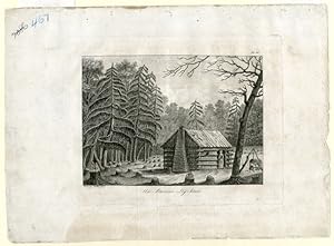
Line engraving, approximately 10 1/4 x 14 inches. Matted. A few small chips and very short closed tears at edges. Numbered twice in pencil at upper left corner. Light dust soiling and dampstaining. About very good. From the atlas of Collot's famous VOYAGE DANS L'AM�RIQUE SEPTENTRIONALE., plate sixteen, depicting a log cabin in a forest clearing. This is considered to be the first real depiction of a classic American log cabin. Collot was sent by the French government to survey the Ohio and Mississippi valleys in 1796, to gauge the military situation on the frontier on the Spanish and American sides of the river, and to determine possible secessionist sentiment among American frontiersmen. Despite numerous difficulties in operating as a secret agent, under suspicion by both American and Spanish officials, Collot gathered a wealth of cartographical material, as well as sounding political waters. Returning to France, he prepared his work for publication and had it printed in 1804. Unfortunately, Napoleon had just sold Louisiana and, not wishing to draw attention to the area of which he had disposed, suppressed the publication. Collot died in 1805, and the sheets of the book and atlas sat in a warehouse for the next two decades. They were then purchased by Arthus Bertrand, the leading French publisher of voyages at the time. According to Bertrand's own testimony, he retained the original maps and plans, issued new titlepages with his imprint, and destroyed a number of sets to make it more scarce. Seller Inventory # WRCAM52523
Bibliographic Details
Title: AN AMERICAN LOG-HOUSE [caption title]
Publisher: [Paris
Publication Date: 1826
Top Search Results from the AbeBooks Marketplace

Seller Image
AN AMERICAN LOG-HOUSE [caption title].
Published by
[Paris. 1826 (i.e. 1804)]., 1826
Used
Seller: William Reese Company - Americana, New Haven, CT, U.S.A.
Seller rating 4 out of 5 stars
![]()
From the atlas of Collot's famous VOYAGE DANS L'AM�RIQUE SEPTENTRIONALE., plate sixteen, depicting a log cabin in a forest clearing. This is considered to be the first real depiction of a classic American log cabin. Collot was sent by the French government to survey the Ohio and Mississippi valleys in 1796, to gauge the military situation on the frontier on the Spanish and American sides of the river, and to determine possible secessionist sentiment among American frontiersmen. Despite numerous difficulties in operating as a secret agent, under suspicion by both American and Spanish officials, Collot gathered a wealth of cartographical material, as well as sounding political waters. Returning to France, he prepared his work for publication and had it printed in 1804. Unfortunately, Napoleon had just sold Louisiana and, not wishing to draw attention to the area of which he had disposed, suppressed the publication. Collot died in 1805, and the sheets of the book and atlas sat in a warehouse for the next two decades. They were then purchased by Arthus Bertrand, the leading French publisher of voyages at the time. According to Bertrand's own testimony, he retained the original maps and plans, issued new titlepages with his imprint, and destroyed a number of sets to make it more scarce. Line engraving, approximately 10� x 14 inches. Matted. A few small chips and very short closed tears at edges. Numbered twice in pencil at upper left corner. Light dust soiling and dampstaining. About very good. Seller Inventory # 52523
Quantity: 1 available