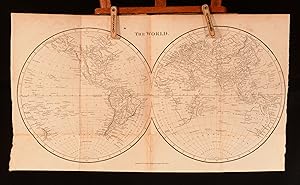
An Atlas For School, Containing Ancient and Modern maps, Drawn From The Best Authorities ; Prefaced by Twenty-Four Problems On Maps, And By A Copious Table of Latitudes and Longitudes

Published by Richard Phillips, London, 1813

  • Hardcover
  • Used
See all details
Item image 1 of 12.

Seller: Rooke Books PBFA, Bath, United KingdomRooke Books PBFA

5-star seller

AbeBooks seller since May 18, 2007

Association member: PBFA

Hardcover

Condition: Used - Very good

US$ 442.83

US$ 25.12 shipping 
Ships from United Kingdom to U.S.A.

Quantity: 1 available

Add to basket
Free 30-day returns

Item description from seller

A very scarce works of cartography profusely illustrated with folding maps. A very scarce work. By the author of several geographical and educational works, the Rev. J. Goldsmith. This volume includes a chapter defining map related terms such scale, longitude and latitudes, a chapter titled problems of maps, a table of latitudes and longitude of notable places, followed by a series of folding maps. In the chapter Problems on Maps, the author provided a series of problems that teachers may set their students. Very much designed as an educational tool, Goldsmith intended this works to be used as a study aid for both teacher and student. There are 15 maps in total, collated complete. With two world maps one being the Stereographic projection and the other the Mercator's Projection, and the remaining featuring the following subjects: Europe, Asia, Africa, North America, South America, the West Indies, Hindostan, England, Scotland, Ireland, the Roman World, Ancient Greece and Palestine. Previous owners ink inscription to the front and rear endpapers. The maps themselves are in very good condition. In a quarter calf binding, with paper covered boards. Externally rubbed with loss to the spine. Bumping to the extremities. light sunnign to the head of the front board. Large crack to the centre of the backstrip. Cut makrs to the rear board, resulting in a small amount of loss. Front hinge is strained, held by cords. Previous owners ink inscription to the front and rear endpapers. Light offsetting towards the front and rear endpapers and pastedowns, towards the hinges. Internally generally firmly bound, strained in places. Pages are generally clean with the odd mark. The map are in very good condition, with Light offsetting the reverse of several maps, with the extremities lightly age toned. Very Good. …

Seller Inventory # 623C35

Bibliographic details

Title
An Atlas For School, Containing Ancient and Modern maps, Drawn From The Best Authorities ; Prefaced by Twenty-Four Problems On Maps, And By A Copious Table of Latitudes and Longitudes
Author
Rev J Goldsmith
Publisher
Richard Phillips, London
Publication year
1813
Condition
Very Good
Book Type
book
Binding
Leather
Illustrator
Unamed
Item weight
0.5 kilograms
Dimensions
9.5" by 6"

Rooke Books PBFA

Bath, United Kingdom

5-star seller

AbeBooks seller since May 18, 2007

Association member:

Shipping rates from United Kingdom to U.S.A.

Item3 to 5 business days2 to 3 business days
First itemUS$ 25.12US$ 31.74
Delivery times are set by sellers and vary by carrier and location. Orders passing through Customs may face delays and buyers are responsible for any associated duties or fees. Sellers may contact you regarding additional charges to cover any increased costs to ship your items.

Payment methods

  • Visa
  • Mastercard
  • American Express
  • Apple Pay
  • Google Pay
  • Bank Draft
  • Bank Wire Transfer
  • Cash
  • Invoice

Specialty

Antiquarian Books

Association member

  • Provincial Booksellers Fairs Association
Members of these associations are committed to maintaining the highest standards. They vouch for the authenticity of all items offered for sale. They provide expert and detailed descriptions, disclose all significant defects and/or restorations, provide clear and accurate pricing, and operate with fairness and honesty during the purchase experience.

Seller's business information

Thompson Acquisitions Ltd

The Dispensary, 8 Cleveland Pl, 8 Cleveland Place East
Bath, United Kingdom BA1 5DJ