About this Item
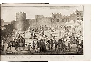
2 works in 3 volumes. First and only editions of the Dutch translation of a description of Arabia, Egypt and the Middle East (ad 1) and an account of a voyage to Arabia and surrounding countries (ad 2). Both works were originally written by the Danish traveller and surveyor Carsten Niebuhr (1733-1815) and published in German, in Copenhagen in 1772. Both works are lavishly illustrated, having together 2 large maps of Yemen and 148 beautifully engraved maps, plans and views of all the regions Niebuhr visited. Fine untrimmed set (giving very large margins) and bound as a matching set, with only the fore-edge of 1 folding plate slightly tattered, a small marginal tear and an occasional leaf with very minor foxing. The bindings show minor wear in the spines and a few small scuff marks on the sides, but are still very good. Lovely copy of two important and complementary works on Arabia and the Middle East, lavishly illustrated.l Hamilton, Europe and the Arab world 48; Howgego, to 1800, N24; Tiele, Bibl. 795-796. Contemporary sprinkled and polished half calf, sewn on 5 cords, sprinkled sides, black spine labels in 2nd of 6 compartments. Untrimmed. With engraved title-page with an engraved vignette by N. van der Meer (2 female figures with a globe and other instruments) and 25 engraved plates numbered I-XXIV, [XXV], including 7 folding showing 1 view of military exercises, 2 Kufic inscriptions (coloured by hand) and 4 maps. The unnumbered map of Yemen (plate size 58.5 x 39 cm) is coloured by hand in outline. The full-page plates include maps, topographic views, costumes, coins, Arabic inscriptions, etc. All by C.J. de Huyser, N. van der Meer, Th. Koning and C. Philips. Pages: [6], XXXXI, [1], 408, [14]; [2], VIII, [6], 484, [2]; [16], 455, [1] pp. With: (2) NIEBUHR, Carsten. Reize naar Arabië en andere omliggende landen.Amsterdam, Steven Jacobus Baalde; Utrecht, Johannes van Schoonhoven & comp. (colophons: printed by Johan Joseph Besseling, Utrecht), 1776-1780. With 2 engraved title-pages, each with an engraved vignette (that for volume 2 from the plate of the 1774 Beschryving with the lettering revised; that for volume 1 copied from it and unsigned), 125 engraved plates numbered I-LXXII, [LXXIII] (vol. 1) & I-LII (vol. 2) (38 folding), showing topographic views, watermills, people, Egyptian and Persian antiquities, Egyptian, Persian, cuneiform and other inscriptions, etc. by C.F. Fritsch, C.J. de Huyser, Th. Koning, G.H. Koning, C. Philips, O. de Vries, Baurenfeind and others. The unnumbered folding map of Yemen ("Tabula Itineraria", plate size 48.5 x 41.5 cm), with the trade routes coloured by hand, covers a smaller area at a larger scale than that in the Beschryving. Seller Inventory # 76OFMZ3CJTCQ
Contact seller
Report this item


