
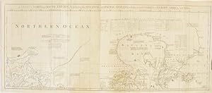
A Chart of North and South America, Including the Atlantic and Pacific Oceans, with the Nearest Coasts of Europe, Africa, and Asia. Chart Containing Part of the Icy Sea with the Adjacent Coast of Asia and America. Chart Comprizing Greenland with the Countries and Islands About Baffin's Bay and Part of Hudson's Bay. [Original Hand-Coloured 1775 Map Sheet 1 Only].
Jeffreys, Thomas
Published by Fleet Street, London Robert Sayer & J. Bennett 1775, 1775
Condition: Used - Very good
Sold by Aquila Books(Cameron Treleaven) ABAC, Calgary, AB, Canada
Association Member:
AbeBooks Seller since October 8, 2001
Seller rating 3 out of 5 stars
![]()
Used
Condition: Used - Very good
Price:
US$ 1,106.41
US$ 19.00 shipping
Ships from Canada to U.S.A.
Ships from Canada to U.S.A.
Quantity: 1 available
Add to basket