


DATOS DE LOS TRABAJOS ASTRONOMICOS Y TOPOGRAFICOS, DISPUESTOS EN FORMA DE DIARIO. PRACTICADOS DURANTE EL AÑO DE 1849 Y PRINCIPIOS DE 1850 POR LA COMISION DE LIMITES MEXICANA EN LA LINEA QUE DIVIDE ESTA REPUBLICA DE LA DE LOS ESTADOS-UNIDOS
Salazar Ylarregui, José
Published by Imprenta de Juan R. Navarro, Mexico, 1850
Used
From
William Reese Company - Americana, New Haven, CT, U.S.A.
Seller rating 4 out of 5 stars
![]()
AbeBooks Seller since July 13, 2006
This specific copy is no longer available. Here are our closest matches for DATOS DE LOS TRABAJOS ASTRONOMICOS Y TOPOGRAFICOS, DISPUESTOS EN FORMA DE DIARIO. PRACTICADOS DURANTE EL AÑO DE 1849 Y PRINCIPIOS DE 1850 POR LA COMISION DE LIMITES MEXICANA EN LA LINEA QUE DIVIDE ESTA REPUBLICA DE LA DE LOS ESTADOS-UNIDOS by Salazar Ylarregui, José.
About this Item
Description:
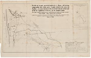
123pp. plus two folding maps. Large octavo. Contemporary half calf, spine gilt. Head of spine rubbed, hinges cracking, corners bumped. Bookplate on front pastedown. Titlepage lightly foxed, minor scattered foxing. Very good. The author was the surveyor for the Mexican boundary survey after the Mexican-American War. This work describes his surveys from San Diego to the confluence of the Gila and Colorado rivers, and much of the text consists of daily entries made between July 1849 and January 1850. The folding maps illustrate the port of San Diego and the area of California and Arizona around the junction of the two rivers. "Salazar gives the earliest detailed account of the previously unsurveyed border regions of California and Central Arizona" - Hill. This book is quite scarce on the market, and this is only the third copy we have encountered in more than fifteen years. The Streeter copy sold to Dawson's Book Shop for $250 in 1968. STREETER SALE 2648. WAGNER-CAMP 190. HILL 1514. HOWES S47, "b." GRAFF 3652. WHEAT TRANSMISSISSIPPI 690, 691. PALAU 286944. Seller Inventory # WRCAM40467
Bibliographic Details
Title: DATOS DE LOS TRABAJOS ASTRONOMICOS Y ...
Publisher: Imprenta de Juan R. Navarro, Mexico
Publication Date: 1850
Top Search Results from the AbeBooks Marketplace

DATOS DE LOS TRABAJOS ASTRONOMICOS Y TOPOGRAFICOS, DISPUESTOS EN FORMA DE DIARIO. PRACTICADOS DURANTE EL AÑO DE 1849 Y PRINCIPIOS DE 1850 POR LA COMISION DE LIMITES MEXICANA EN LA LINEA QUE DIVIDE ESTA REPUBLICA DE LA DE LOS ESTADOS-UNIDOS.
Published by
Mexico: Imprenta de Juan R. Navarro, 1850., 1850
Used
Seller: William Reese Company - Americana, New Haven, CT, U.S.A.
Seller rating 4 out of 5 stars
![]()
123pp. plus two folding maps. Large octavo. Contemporary half calf and embossed black cloth, spine gilt. Head of spine rubbed, hinges cracking, corners bumped. Bookplate on front pastedown. Titlepage lightly foxed, minor scattered foxing. Very good. The author was the surveyor for the Mexican boundary survey after the Mexican-American War. This work describes his surveys from San Diego to the confluence of the Gila and Colorado rivers, and much of the text consists of daily entries made between July 1849 and January 1850. The folding maps illustrate the port of San Diego and the area of California and Arizona around the junction of the two rivers. "Salazar gives the earliest detailed account of the previously unsurveyed border regions of California and Central Arizona" - Hill. Scarce in the trade. The Streeter copy sold to Dawson's Book Shop for $250 in 1968. STREETER SALE 2648. WAGNER-CAMP 190. HILL 1514. HOWES S47, "b." GRAFF 3652. WHEAT TRANSMISSISSIPPI 690, 691. PALAU 286944. Seller Inventory # 40467
Quantity: 1 available