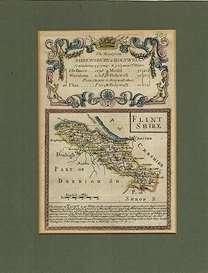
Map of Flintshire.
FLINTSHIRE. EMANUEL BOWEN.
From R.G. Watkins Books and Prints, Ilminster, SOMER, United Kingdom
Seller rating 4 out of 5 stars
AbeBooks Seller since February 18, 1999
From R.G. Watkins Books and Prints, Ilminster, SOMER, United Kingdom
Seller rating 4 out of 5 stars
AbeBooks Seller since February 18, 1999
About this Item
Engraved County Map, with later hand-colouring; above map, decorative cartouche with title "Road from Shrewsbury to Holywell", on reverse, road map from Shrewsbury to Wrexham, from "Britannia Depicta", Sheet 265/266, very good condition, Seller Inventory # RGW13028
Bibliographic Details
Title: Map of Flintshire.
Publisher: 1720 or later. 7.5in x 5in.
Publication Date: 1720
Store Description
Payment in sterling before despatch of books. Postage is extra.
Books may be returned within 7 days of receipt, if found not to be as
described.
Please pay by sterling cheque, banker's draft or bank transfer.
Also, American Express, Mastercard and Visa debit and credit cards accepted.
Orders usually ship within 2 business days. Shipping costs are based on books weighing 2.2 LB, or 1 KG. If your book order is heavy or oversized, we may contact you to let you know extra shipping is required.
In the UK, maximum postal charge is £9.
Overseas postage charged at cost.
Would customers, specify air or surface mail.
For urgent delivery, United Parcel Service is available.
All consignments are insured for which no charge is made
Payment Methods
accepted by seller